Article of the Month - January 2026
|
Application of the Fit-for-Purpose Land
Administration related to the concepts of the Social Tenure Domain Model
in irregular urban areas in Brazilian Municipalities
Pedro Afonso Cardoso Manarin and Everton Da Silva,
Brazil
 |
 |
| Pedro Afonso Cardoso Manarin |
Everton Da Silva |
This article in .pdf-format
( 9 pages)
SUMMARY
The Multipurpose Land Cadastre (MLC) is an essential instrument for
territorial management. However, traditional methods of managing
cadastre data often do not cover areas of irregular occupation,
hindering urban planning and the implementation of public policy
instruments that are essential for promoting territorial justice. In
this context, the fit-for-purpose (FFP) approach and the Social Tenure
Domain Model (STDM) emerge as viable, flexible, and socially inclusive
alternatives. Thus, the main objective of this study is to analyze the
efficiency and applicability of FFP in relation to the concepts of STDM
in irregular occupations in Brazilian municipalities, using as a case
study an irregular occupation in the Municipality of Criciúma - SC. The
methodology adopted involved a literature review and the analysis of a
practical application. The information from the project carried out by
the municipality was obtained from the specific sector of municipal
administration, allowing a comparison between the configuration before
and after the intervention. As a result, it was found that the
initiative covered an area of 29,443.61 m² (29.44 ha), where 94 lots
were recorded, of which 77, approximately 81.9%, presented data from
their respective occupants. It was also found that 129 buildings were
registered, totaling a built-up area of 8,149.72 m². These data
highlight the existing informality and reinforce the importance of more
accessible methodologies to ensure an updated cadastre consistent with
reality. Therefore, it was verified that the combination of STDM, FFP,
and the Multipurpose Land Cadastre (MLC) is effective in promoting more
inclusive and democratic territorial management, aligned with the
principles of the right to the city, contributing to more effective
public policies, especially in contexts of social vulnerability.
1. INTRODUCTION
The Multipurpose Land Cadastre (MLC) has been consolidated as an
indispensable instrument for territorial management, given the relevance
of its information for actions at the municipal level, covering both
urban and rural areas, as well as at the regional scale. This expansion
of the applicability of the MLC has been made possible, to a large
extent, by technological advances that have enabled greater
interoperability between systems. However, it is important to highlight
that technology is only one of the necessary elements for its
effectiveness. The technical training of the professionals involved and
cooperation between different public and private agents are equally
fundamental for the successful implementation of the MLC in municipal
administrations (Silva et al., 2023).
Furthermore, having a detailed database on urban parcels allows for a
clear reflection of the organization of urban space. The quality of life
in cities is closely related to the proper use of property and
collective well-being. For this to be achieved, it is essential to have
regulations that serve the public interest and promote the common good,
ensuring, above all, the fundamental rights of every citizen in a
sustainable city. Among these rights, access to adequate housing, basic
sanitation, urban infrastructure, public services, transportation,
employment, and leisure stand out (Silva et al., 2023).
However, most small and medium-sized Brazilian cities, approximately
88%, face challenges arising from disorderly urban growth and irregular
land occupation. This reality directly impacts environmental
preservation and, consequently, compromises the population’s quality of
life. In this context, the Multipurpose Land Cadastre (MLC) plays a
strategic role in urban planning and decision-making processes and,
therefore, must be permanently updated and structured to provide
accurate information to professionals responsible for various areas of
territorial management (Silva et al., 2023).
In addition, the guarantee of property rights must be ensured by a
legal framework that, while protecting this right, also provides
flexible alternatives capable of encompassing informal realities,
particularly in developing countries. In these regions, millions of
people live in properties without legal registration, preventing them
from fully exercising their rights to possession and access to property.
This situation reveals limitations in traditional territorial management
systems, which fail to include such properties in official cadastres,
even preliminarily. In this context, the Social Tenure Domain Model
(STDM) emerges as an inclusive solution, allowing for the representation
of relationships between people and land regardless of the degree of
formality, legality, or technical precision. Especially aimed at urban
areas with irregular occupations, traditional rural zones, and
post-conflict regions, STDM seeks to promote a more equitable land
administration, expanding access to tenure security for historically
marginalized populations (Lemmen, 2010).
In the same vein, it is evident that territorial management still
relies on traditional technical methodologies, mainly in the areas of
land registration, property valuation, and land cadastre. Although this
approach is well-established, it often proves rigid and resistant to
change, hindering the adoption of more participatory and flexible
models. Even with technological advances that have broadened the
possibilities of managing territory, in many developing countries,
access to formal land administration systems is still restricted to a
portion of the population. This reveals the existence of structural
barriers and a slow adoption of more inclusive and innovative ideas
(Njogu & Gitau, 2023).
Therefore, given the challenges currently faced, the Fit-For-Purpose
(FFP) approach emerges as an effective alternative for updating
multipurpose land cadastres in irregular occupations. This model
proposes that the spatial framework underlying large-scale mapping be
developed with a focus on addressing the concrete land demands of a
country or specific region, prioritizing functionality and practical
applicability instead of merely adhering to advanced technical standards
that are often inaccessible (Enemark et al., 2014).
It is an inclusive and participatory approach, based on human rights
principles. Among its main advantages is the possibility of implementing
efficient territorial management systems within shorter timeframes and
with reduced and feasible costs. By adopting this methodology,
governments and professionals are provided with a concrete opportunity
to promote significant progress in land administration, especially in
contexts where resources are limited, and the demand for regularization
is urgent. The fit-for-purpose proposal, therefore, proves to be an
adaptable solution to different realities and scalable in both technical
and institutional terms, capable of generating significant medium-term
impacts and contributing to the effective improvement of land
administration at the global level (Enemark et al., 2014).
It is noteworthy that studies carried out in Itaji-Ekiti indicate
that the Social Tenure Domain Model (STDM) has proven to be an effective
instrument in documenting land rights of vulnerable rural communities.
The application of the model highlighted its potential as a territorial
management tool aimed at low-income populations, standing out for its
participatory approach in which the involvement of the local community
was fundamental to the success of the data collection and recording
process. The use of aerial and satellite imagery also proved to be a
practical strategy for mapping. The results showed that STDM meets the
needs of small landowners in the region, offering a viable alternative
for the land inclusion of populations historically excluded from formal
systems (Babalola & Hulla, 2022).
In view of this, given the reality in which several municipalities
face difficulties with irregular occupation, the present study has as
its main objective to analyze the efficiency and applicability of the
Fit-For-Purpose cadastre in relation to the concepts of the Social
Tenure Domain Model in irregular occupations in Brazilian
municipalities, using as a case study an irregular occupation in the
Municipality of Criciúma - SC.
2. MATERIAL AND METHOD
For the preparation of this article, a literature review was
initially carried out focusing on the Multipurpose Land Cadastre (MLC),
the Social Tenure Domain Model (STDM), as well as the Fit-For-Purpose
(FFP) approach, with the aim of understanding their characteristics,
applications, and how this method can be incorporated into the
principles of the MLC.
Subsequently, an area characterized by irregular occupation was
selected, which did not have individualized parcel cadastre and was
subjected to a cadastre process conducted by the municipality using the
fit-for-purpose approach.
With the support of the Municipality of Criciúma, an aerial image of
the area in question, obtained by the municipality through an unmanned
aerial vehicle (UAV), was made available and served as the basis for the
development of the cadastre project. In addition, information was
provided on the configuration of lots before and after the cadastre
update, as well as data from the municipal database regarding the
irregular occupation.
Based on this investigation and the information provided, graphic
representations were produced with the purpose of deepening the data
analysis and assessing the impact of adopting a flexible cadastre method
in a socially vulnerable region marked by irregular occupations.
3. RESULTS AND DISCUSSION
Criciúma is a Brazilian municipality located in the southern part of
the state of Santa Catarina, with a territorial area of 234.794 km². It
is situated approximately 195 km from the state capital, Florianópolis.
Criciúma is the main city of the Coal Metropolitan Region and the most
populous city in southern Santa Catarina. With a population of 214,493
inhabitants in 2022, Criciúma ranks as the eighth most populous
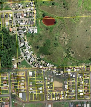
municipality in the state (IBGE, 2022). The area selected for the
present study, outlined in red in Figure 01, partially covers the
neighborhoods of São Defende and São Sebastião, located within the
municipality of Criciúma, totaling an area of approximately 29,443.61
m². The irregular occupation identified in this region affects both
public land, registered under the Municipality of Criciúma, and
properties belonging to private owners.
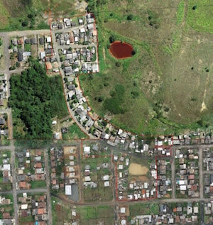
Figure 1. Delimitation of the Study Area
It can be observed from the image in Figure 2, referring to the year
2001, that the occupation of the site has been taking place for over 20
years. Some buildings were already present at that time, and they still
remain, with their respective expansions and renovations.
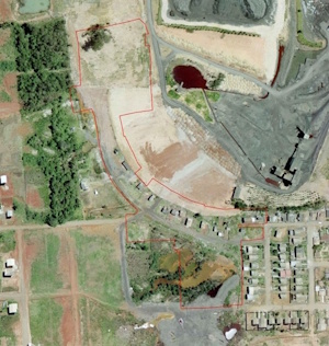
Figure 2. Study Area Delimitation in 2001
For a better understanding of the results obtained, it is necessary
to describe the procedure adopted by the municipality in the cadastre
update process. The first step consisted of obtaining an aerial image
through a UAV. The image was subsequently processed and used as a basis
for mapping the existing buildings, as well as for delineating the lots,
since many of them presented visible physical divisions.
Next, on-site visits were conducted with the aim of photographing all
the buildings and collecting data on their construction characteristics.
During this stage, the lot boundaries were verified with the
collaboration of the residents, which added greater legitimacy to the
process and encouraged community participation. In parallel, teams from
the Department of Social Assistance and Housing accompanied the
fieldwork, collecting socioeconomic information about the occupants and
their family units. Once the field data collection phase was completed,
the information obtained was consolidated and entered into the cadastre
system. This phase included the registration of buildings, linking the
corresponding photographic images, adjusting lot boundaries, and adding
data regarding the occupants of each unit.
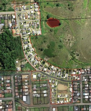
As a result of this process, Figures 03 and 04 show a clear
discrepancy between the previous and the current configuration of the
municipality’s territorial cadastre. In the original situation,
represented by Figure 03, large lots were identified, many of which
contained unregistered informal occupations. In Figure 04, produced
after the cadastre update, it is possible to visualize the new
delineation of the lots, reflecting more accurately the actual
occupation of the territory, as effectively used by the residents.
Figure 3 and 4. Before and After the Update
From the development of the project, it was possible to extract
relevant information regarding the results obtained in the cadastre
process. One of the main findings refers to the number of parcels
incorporated or updated in the municipality’s Multipurpose Land
Cadastre, totaling 94 lots. This number reveals a significant volume of
irregularly occupied areas that, until then, had no formal cadastre
registration. Such absence compromised the ability of the public
administration to fulfill its legal duties and implement effective
public policies based on reliable, accessible, and transparent data for
society.
Additionally, it was found that among the 94 identified lots, 77 have
complete information regarding their respective occupants, corresponding
to approximately 81.9% of the total. Although not all residents
participated in the cadastre update process, it is noteworthy that the
inclusion of this information remains open to the community. Occupants
who have not yet been registered may approach the competent municipal
agencies to carry out the proper cadastre registration, as well as those
seeking to update their data. This reinforces the importance of
continuous and participatory maintenance of the land cadastre, aiming
for data accuracy in relation to the urban reality.
Another relevant aspect concerns the number and built-up area of the
identified buildings. A total of 129 constructions were registered,
amounting to a built area of 8,149.72 m². This information highlights
the spatial dimension of the occupation and underscores the urgency for
public authorities to have precise information to support urban
planning, the formulation of housing policies, and the control of land
use and occupation.
4. CONCLUSIONS
The present study demonstrated that the application of the
Fit-For-Purpose (FFP) approach combined with the Social Tenure Domain
Model (STDM) represents a viable, effective, and socially inclusive
alternative for updating the Multipurpose Land Cadastre (MLC) in areas
characterized by irregular occupations. Through the case study conducted
in the municipality of Criciúma – SC, it was possible to verify that the
adoption of flexible methodologies, based on the reality of the
territory and community participation, allows not only the technical
mapping of parcels but also the incorporation of essential information
about the occupants and their buildings, significantly contributing to
the strengthening of local land governance.
The inclusion of 94 previously unregistered lots, of which 77 now have
complete occupant data, and the registration of 129 buildings with a
total built-up area exceeding 8,000 m², highlight the importance of an
accessible and continuous cadastre system capable of accurately
reflecting the real occupation of urban land. These results reinforce
the strategic role of the MLC as a foundation for urban planning, the
formulation of public policies, and the promotion of sustainable
development, especially in contexts of social vulnerability.
Furthermore, the study confirms that the effectiveness of the MLC does
not rely solely on the adoption of advanced technologies but also on
institutional engagement, the qualification of the professionals
involved, and the adoption of legal guidelines that prioritize the
common good, access to adequate housing, and the promotion of social
justice.
It can be concluded, therefore, that the integration of the STDM, the
fit-for-purpose approach, and the Multipurpose Land Cadastre can
significantly contribute to addressing the challenges of urban
informality, promoting more inclusive and democratic territorial
management aligned with the principles of the right to the city.
REFERENCES:
- Babalola, K.H., Hulla, S. A. (2022). Using a domain model of
social tenure to record land rights: A Case Study of Itaji-Ekiti,
Ekiti State, Nigeria. South African Journal of Geomatics, 8(2),
221–237.
https://doi.org/10.4314/sajg.v8i2.8
- Enemark, S., Bell, K.C., Lemmen, C. and McLaren, R. (2014).
Fit-for-Purpose Land Administration. FIG publication No. 60.
International Federation of Surveyors (FIG). Copenhagen, Denmark, 40
p,
fig.net/resources/publications/figpub/pub60/figpub60.pdf
- IBGE (2022). Criciúma (SC),Cidades e Estados, Instituto
Brasileiro de Geografia e Estatistica. [online] Available at:
https://www.ibge.gov.br/cidades-e-estados/sc/criciuma.html.
- Lemmen, C.H.J. (2010) The social tenure domain model: a pro-poor
land tool. FIG publication No. 52. International Federation of
Surveyors (FIG). Copenhagen, Denmark, 20 p,
https://www.fig.net/resources/publications/figpub/pub52/figpub52.pdf
- Njogu, S. and Gitau, J. (2023). The Social Tenure Domain Model
framework: Lessons and opportunities from a decade of experiences in
the country applications. FIG Working Week 2023: Protecting Our
World, Conquering New Frontiers International Federation of
Surveyors.
- Silva, Everton da et al. (2023). Cadastro Territorial
Multifinalitário aplicado à Gestão Municipal. UFSC. Florianópolis,
Brazil, 214p.
https://doi.org/10.5281/zenodo.7869277
BIOGRAPHICAL NOTES
Pedro Afonso Cardoso Manarin holds a degree in Civil
Engineering from the Federal Institute of Education, Science and
Technology of Santa Catarina (2025) and is a student in the
Transportation Engineering and Territorial Management Program at the
Federal University of Santa Catarina.
Everton Da Silva holds a degree in Surveying
Engineering from União das Faculdades de Criciúma (1992), a Master’s in
Civil Engineering from the Federal University of Santa Catarina (1999),
and a Ph.D. in Production Engineering from the Federal University of
Santa Catarina (2006). He is a professor at the Federal University of
Santa Catarina, affiliated with the Department of Geosciences and the
Graduate Program in Transportation Engineering and Territorial
Management, where he works in the research line of Multipurpose Land
Cadastre. He has coordinated cadastral survey projects and mass property
valuation for fiscal purposes in several Brazilian municipalities. He is
an associate professor at the Lincoln Institute of Land Policy, where he
collaborates in both online and in-person courses. He is a member of the
Multipurpose Cadastre Academic Network (RACAM) and of the CTM Community
(ReDus). He is also the leader of the Territorial Observation and
Transformation Group – GOTT (gott.ufsc.br).
CONTACTS
Pedro Afonso Cardoso Manarin
Universidade Federal de Santa Catarina
Florianópolis
BRAZIL
Everton Da Silva
Universidade Federal de Santa Catarina
Florianópolis
BRAZIL
Phone: +55 (48) 3721-8596
Website: http://gott.ufsc.br/