Article of the Month -
June 2005
|
AFREF - Background and Progress towards a Unified Reference
System for Africa
Richard WONNACOTT, South Africa
 This article in .pdf-format
1) This paper has
been prepared and presented at the FIG Working Week / GSDI-8 Conference in
Cairo, Egypt, April 16-21, 2005.
1. INTRODUCTION
In the introduction to the New Partnership for Africa's Development
(NEPAD) dated October 2001, African leaders recognised "that they have a
pressing duty to eradicate poverty and to place their countries, both
individually and collectively, on a path of sustainable development, and, at
the same time, to participate actively in the world economy and body
politics."
Many of the objectives and initiatives of NEPAD depend on the
establishment and maintenance of sound regional or continental
infrastructure of reliable geo-spatial information. It is essential,
therefore, that the co-ordinate systems or foundation on which that
information is based be both uniform and based on modern positioning
technology throughout the region.
The Africa Reference Framework project (AFREF) is an African initiative
with international support designed to unify the co-ordinate reference
systems in Africa using Global Navigation Satellite Systems (GNSS) and, in
particular, the Global Positioning System (GPS) as the primary positioning
tool. The outcome of this project will be a uniform and consistent
co-ordinate system covering Africa to be used as the fundamental reference
system for all regional and continental geo-spatial information and planning
and development projects across a wide spectrum of disciplines. The AFREF
project will, therefore, support the goals and initiatives of NEPAD.
2. RATIONALE AND BACKGROUND
One of the main long term objectives of the New Partnership for Africa’s
Development (NEPAD) is “to eradicate poverty in Africa and to place African
countries, both individually and collectively, on a path of sustainable
growth and development and thus halt the marginalisation of Africa in the
globalisation process” (NEPAD, 2001). NEPAD was developed by African leaders
and is based on national and regional priorities and development plans for
the continent’s renewal. One of the priority areas is a focus “on the
provision of essential regional public goods (such as transport, energy,
water, ICT, disease eradication, environmental preservation, and provision
of regional research capacity), as well as the promotion of intra-African
trade and investments. The focus will be on rationalising the institutional
framework for economic integration, by identifying common projects
compatible with integrated country and regional development programmes, and
on the harmonisation of economic and investment policies and practices”. Any
meaningful regional development programmes will require maps and other
geographic information products for effective planning and efficient
implementation. As a result of the importance of geographic information, the
science and technology platform of NEPAD includes an objective to “promote
cross-border co-operation and connectivity” and an action to “establish
regional co-operation on product standards development and dissemination,
and on geographic information systems” (NEPAD, 2001)
The fundamental point of departure for any project, application, service
or product which is reliant on some form of geo-referencing, must be a
uniform and reliable co-ordinate reference system. Geographic information
services and products provide the link between all activities and the places
or locations where those activities take place. One does not build a house
without a foundation or secure frame. Most countries have developed
co-ordinate reference systems and frames which are used for national
surveying, mapping, remote sensing, Geographical Information Systems (GIS)
and development programmes. Although these systems are in existence in many
countries, the state of repair and extent of their applications varies
considerably.
There are over 50 countries in Africa all of which are considered as
developing nations and each with is own difficulties and challenges. Each of
these countries have their own co-ordinate reference system and frame.
Additionally, there are some countries that have more than one system each
based on a different datum. A number of the former British colonies in
Southern and East Africa adopted the Cape Datum co-ordinate system based on
the Clarke 1880 spheroid but even these countries have different
realizations of what, in name, is the same thing.
Although there remain a number of areas of conflict within Africa, there
are also a number of regions where peace has been restored. With the
restoration of peace has come the resurgence of development of these
regions. The need to coordinate planning and development efforts within
countries and across national borders in line with the ideals of NEPAD has
become paramount and cannot be achieved successfully if the fundamental
point of departure for these planning projects, i.e. the co-ordinate
reference frame, is not uniform and of an appropriate modern standard
(Windhoek Declaration, 2002).
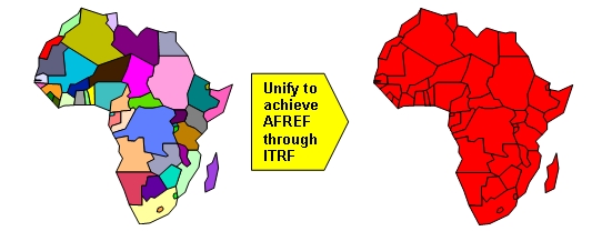
Figure 1: AFREF is conceived as unifying the
national reference frames of Africa into a common reference frame for the
continent.
The African Geodetic Reference Frame (AFREF) is conceived, therefore, as
a unified geodetic reference frame for Africa. It will be the fundamental
basis for the national three-dimensional reference networks fully consistent
and homogeneous with the International Terrestrial Reference Frame (ITRF).
When fully implemented, it will consist of a network of continuous,
permanent GPS stations such that a user anywhere in Africa would have free
access to and would be, at most, 1000km from such stations. Full
implementation will include a unified vertical datum and support for efforts
to establish a precise African geoid, in concert with the African Geoid
project activities (Wonnacott, 2003).
Apart from being fundamental to all infrastructure, planning and
development projects, AFREF and the network of permanent GPS base stations
upon which it will be based, has vast potential for the promotion of geodesy
and surveying, geo-information, earth and atmospheric science, disaster
mitigation, the monitoring of crop and vegetation distribution and animal
migration patterns. The implementation of AFREF and its applications will
provide a major platform for the enhancement of skills and skills transfer
in these sciences and further some of the objectives and actions of the
NEPAD science and technology platform.
3. THE AFRICAN DOPPLER SURVEY
Prior to the introduction of GPS as an easily accessible positioning
tool, the US Navy Navigation Satellite System (US NNSS), TRANSIT, was
available to the geodetic and surveying community. The system was commonly
known as the Doppler positioning system primarily because of the observing
principal upon which it was based. In order to achieve the accuracies
required for geodetic applications, it was essential that at least two
receivers, preferably more, observed and recorded the Doppler shifted
satellite transmitted frequencies simultaneously. The logistics of a survey
extending over large areas with an inter-station spacing of 500 km or more
was not easy to ensure that all stations recorded data simultaneously
particularly with the added difficulty of poor telecommunications between
stations.
In spite of these difficulties, however, a project was designed in the
1980’s to unify the geodetic datums in Africa using Doppler as the primary
observing tool. The project was known as the Africa Doppler Survey (ADOS).
Doppler receivers were not as readily available as GPS receivers today and
there were far fewer geodesists and surveyors experienced in the use of the
equipment for geodetic applications than there are GPS experts today. The
main objectives of the ADOS project were (IAG, 1981):
- to provide zero-order control for future geodetic networks for mapping
control;
- to provide control for datum unification and strengthening; and
- to provide an accurate geoid for Africa.
The project was planned and implemented by the IAG in conjunction with
the African Association of Cartography (AAC), the United Nations Economic
Commission for Africa (UNECA) and the Regional Centre for Mapping of
Resources for Development (RCMRD). Field observations were carried out by
African National Mapping Organisations (NMO’s) and international geodetic
organisations under bilateral agreements. Although nearly 300 zero order
points were established within the project by the end of 1986, the goal to
unify the geodetic datums in Africa was not met. The main reasons for this
were:
- the logistics of carrying out the observations simultaneously proved
exceptionally difficult indeed and limited the amount of suitable data;
- the rationale was not fully understood by participating countries
resulting in a lack of motivation and enthusiasm for the project;
- the project was planned almost entirely by the IAG and the
international community with little input from African countries;
- there were no set observing standards and procedures resulting in
observations of unacceptable standard and;
- the bilateral agreements between countries and sister organisations
did not always materialize.
Although ADOS failed to meet its primary objectives, it did serve to
provide a number of valuable lessons which will be carried forward into the
AFREF project. Perhaps the most significant differences between the two
projects has been the change in positioning technology notably the
introduction of GPS, the concept of continuously operating GPS base
stations, the establishment of the International GPS Service (IGS) and its
global network of GPS base stations and the services and products derived
from the IGS. It is now no longer essential that all roving receivers
operate simultaneously since one is able to rely on the IGS infrastructure
of base stations. A set of standards and procedures has been introduced by
the IGS for the establishment of permanent base stations. Apart from the
technological changes, the fact that African countries are actively involved
in the planning, managing and execution of AFREF will be a major positive
feature and difference between this project and ADOS.
4. SIMILAR REGIONAL REFERENCE FRAME PROJECTS
Projects with similar goals and objectives have been undertaken elsewhere
in the world. The European Reference Frame (EUREF) is perhaps the longest
running and best established project of this nature to have been undertaken.
EUREF was founded in 1987 as a Sub-Commission within the IAG and deals with
the definition, realization and maintenance of the reference frame for
Europe. It has matured to the stage where there are clearly defined sets of
activities such as the establishment and maintenance of the European
Terrestrial Reference System and European Vertical Reference System. These
activities are based on a network of permanent GPS/GLONASS receivers (EUREF,
2005).
Similar projects have been established for South and Central America
(SIRGAS), Asia-Pacific, North America and, although not entirely the same as
others, Antarctica all of which are represented as Sub-Commissions of the
IAG.
5. PROGRESS TO DATE
Since the Global Spatial Data Infrastructure meeting held in Cape Town in
March 2000, where the need for a unified reference frame for Africa was
first expressed, many meetings and workshops have been held to deal with
AFREF either directly or indirectly. Currently, there are nearly 25
countries throughout Africa that have expressed interest in AFREF while the
number of international organisations with interest in AFREF has also
increased since the project was first proposed.
Perhaps the first meeting or workshop since the completion of ADOS
dedicated to the unification of reference frames in Africa was held in
Tunisia in May 2000. This workshop was attended by 6 North African countries
and was largely of an exploratory nature to find ways and means of unifying
datums in the region (Altamimi, 2004).
A similar, but unrelated meeting dedicated to AFREF, was held in Cape
Town in March 2001 as part of the Conference of Southern African Surveyors
(CONSAS). The purpose of this meeting was largely to try to gauge the level
of interest in the project. Representatives attending the meeting were
mainly from the National Mapping Organisations of Southern African countries
as well as representatives from the IAG, IGS and EUREF. The consensus of
opinion from attendees was that the project should go ahead and that the IAG
should be the lead international organisation to give AFREF the necessary
technical support. It was also recognised that AFREF must include both the
horizontal and vertical components of a unified continental reference frame
similar to EUREF. It was also recognised at this meeting that the logistics
of undertaking such a project involving the more than 50 African countries
simultaneously would probably result in failure and that it should be
organized on a regional basis. This concept has now become one of the
fundamentals of the current organisational structure of AFREF.
The IAG was formally approached to support AFREF and to endorse the
project at the European Geophysical Society (EGS) General Assembly in Nice
in April 2001. At the EGS meeting in April the following year, 2002, the
wheels were set in motion within IAG to establish a formal structure within
IAG itself to deal with AFREF. The North African component of AFREF, NAFREF,
representing Algeria, Egypt, Libya, Morocco, Mauritania and Tunisia
continued to meet and in October 2003 signed a Protocol of Agreement with
the IAG to work towards the attainment of a unified reference system for the
region. (Altamimi, 2004)
The US Government and the United Nations Office for Outer Space Affairs
(UNOOSA) sponsored a regional workshop in Lusaka, Zambia in July 2002 on the
“Use and Application of Global Navigation Satellite Systems (GNSS)”. The
workshop was the fourth in a series held in South America, Eastern Europe,
South East Asia and the Lusaka workshop which included the African and
Middle Eastern regions. An important aspect of the workshop was that there
was a good representation of countries from all regions in Africa. One of
the major recommendations on Surveying, Mapping and Earth Science emanating
from the UNOOSA report (UNOOSA, 2003) on the four workshops was to:
“Establish a continental reference for Africa, or African Reference Frame
(AFREF), consistent with the International Terrestrial Reference Frame
(ITRF)”.
The next important milestone was a workshop held in Windhoek, Namibia in
December 2002 prior to the Regional Centre for Mapping of Resources for
Development (RCMRD) technical meetings. The important feature of the
workshop was the preparation of the “Windhoek Declaration” in which the 8
Southern and East African countries represented at the meeting including the
RCMRD, committed themselves to support AFREF and its objectives and
principles. The declaration was accepted by the United Nations Committee for
Development Information (CODI) and formed the basis upon which CODI -
Geographical Information (CODI-GEO) established an AFREF working group in
August 2004.
Also in July 2002, an application for financial assistance for AFREF was
submitted on behalf of the IUGG/IAG and other organisations to the
International Council for Science (ICSU). The application was unfortunately
not successful but in preparing the application some focus was placed on
formulating the objectives of AFREF which since then have become the
cornerstone of the project. These objectives are to (Neilan & Wonnacott,
2002):
- Define the continental reference system of Africa. Establish and
maintain a unified geodetic reference network as the fundamental basis for
the national 3-d reference networks fully consistent and homogeneous with
the global reference frame of the ITRF;
- Realize a unified vertical datum and support efforts to establish a
precise African geoid, in concert with the African Geoid project
activities;
- Establish continuous, permanent GPS stations such that each nation or
each user has free access to, and is at most 1000km from, such stations;
- Provide a sustainable development environment for technology transfer,
so that these activities will enhance the national networks, and numerous
applications, with readily available technology;
- Understand the necessary geodetic requirements of participating
national and international agencies; and
- Assist in establishing in-country expertise for implementation,
operations, processing and analyses of modern geodetic techniques,
primarily GPS.
One of the driving principles upon which AFREF has been established is
that the project must be designed, managed and executed from within Africa
with technical assistance and expertise being provided by the international
geodetic community. In addition to this, the concept of continental
coordination with regional and national implementation has been paramount.
The structure of the CODI-GEO Working Group on AFREF was accepted at a
workshop hosted by the African Association of Remote Sensing of the
Environment (AARSE) in Nairobi in October 2004. The general organizational
structure of the working group is given in figure 2.
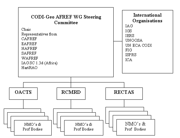
Figure 2: Organizational structure of CODI-GEO
Working Group on AFREF.
The structure shown in Figure 2 reflects the broad concept of AFREF that:
- it is to be designed, managed and executed from within African;
- it is to be organized on a regional basis;
- it is to be executed at the national level; and
- technical expertise and support will come from the international
geodetic community.
The importance of the regional centres cannot be underplayed as,
collectively they already represent a reasonably high percentage of African
countries. They have an important role to play in the “regional” aspect of
AFREF and are better equipped to communicate and liaise with their member
countries. Starting from the North, l'Organisation Africaine de Cartographie
et de Teledetection (OACT) represents largely the Arab speaking countries of
that region, while in West Africa, the Regional Centre for Training in
Aerospace Surveys (RECTAS) represents both French and English speaking West
African countries. The Regional Centre for Mapping of Resources for
Development (RCMRD) represents a reasonably large number of East and
Southern African countries.
Perhaps the most important role players in the project are the National
Mapping Organisations. The NMO’s are going to be responsible for the
implementation of all phases of the project from the installation and
operation of GPS base stations right through to the final conversion to ITRF
of the National reference frames for which they are responsible. Even once
the conversion is complete, historical data based on previous systems will
also have to be converted where necessary. This is particularly the case of
cadastral records for taxation purposes and to ensure the continuity of
security of title.
The Hartebeesthoek Radio Astronomy Observatory (Hart RAO) in South Africa
also has an important role to play in AFREF as it is the only facility in
Africa that is a regional data centre for the IGS and it is therefore
natural that all data generated by the permanent GPS base stations should be
archived at HartRAO. This, however, does not exclude the regional centres
from archiving data from their respective regions. HartRAO is also important
in that it is one of very few facilities globally where VLBI, SLR, GPS,
DORIS and GLONASS are all co-located at the same site.
6. PRESENT SITUATION
From an organizational point of view, a working group has been
established by CODI-GEO to manage AFREF which enjoys the support of numerous
international organizations that are capable of giving the project technical
support. Apart from technical support, these organizations, which include
the IAG, IGS, IERS, UNOOSA, UNECA CODI, FIG, ICA and ISPRS among others, are
able to leverage financial assistance from donor organisations, countries
and equipment manufacturers. To strengthen this support, the IAG has
established Sub-Commission 1.3d Africa within its Commission 1 Reference
Frames. In addition to the establishment of this Sub-Commission, the IGS, a
service organization of the IAG has come out very strongly in support of
AFREF.
From an infrastructure point of view, there are already at least 15 IGS
stations in Africa equipped with GPS receivers. The quality and regularity
of data reception from these stations varies considerably and although it
would appear that a station exists at a certain location, a continuous flow
of data may be somewhat intermittent or even have ceased altogether. There
are also a number of continuously operating base stations which have been
installed according to IGS standards but have not been registered as such.
This is the case within South Africa where a network of 35 stations is
currently in operation. There may be other similar cases such as continuous
base stations at major airports or scientific institutions and which may be
suitable IGS stations provided some antenna and receiver upgrades are
undertaken. Figure 3 shows the distribution of IGS registered space
observing techniques in Africa.
There are many contractors and developers working in Africa who require
geospatial information and maps as part of their contracts. The mapping and
geospatial information that is available from the NMO’s is normally based on
the National co-ordinate systems currently in use in the particular country.
These are based on old reference frames and are generally not compatible
with modern positioning technology and the GPS reference frame, WGS84. The
result is that, although contractors use GPS as the fundamental positioning
tool, a multitude of loosely related local co-ordinate systems are being
established.
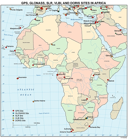
Figure 3: Distribution of GPS, GLONASS, SLR, VLBI and DORIS observing
systems in Africa. (http://cddisa.gsfc.nasa.gov/africamap.gif
viewed 15 January 2005)
At the national level, South Africa converted to ITRF91 (epoch 1994.0)
from the beginning of 1999 after recomputing the entire network using
original terrestrial observations and a selection of about 200 points which
were surveyed by GPS. The process was extremely time consuming but has
resulted in a very “clean” reference frame (Newling 1993, Wonnacott 1997).
Botswana converted to an ITRF2000 based reference framework in 2002 and in
the process used GPS data derived from the South African network of
permanent base stations in addition to data from a number of IGS points. The
latter point is important in that it shows that meaningful GPS observations
can be undertaken even though no base stations are available within one’s
own country.
7. THE WAY FORWARD
With organisational structures in place to deal with AFREF and a wide
range of international organisations having committed themselves to giving
the project their support, the time is fast approaching to commence with the
establishment of a continental wide network of permanent GPS base stations.
Clearly, funding for the purchase of receivers and ancillary equipment is
necessary and perhaps the next phase will be to secure sufficient funding to
install an intial network of about 25 base stations throughout Africa.
Besides the cost of equipment and installation, ongoing funding will be
required for telecommunication and maintenance of the network to ensure a
continuous flow of data and to maintain the network. Experience has shown
that although such networks are called “continuous”, this is very rarely the
case because of various equipment, power and telecommunication failures
which all require some form of maintenance funding. It has been estimated
that the cost of equipment for 25 stations will be approximately $US1.1
million while telecommunication and maintenance costs for these stations
will be approximately $US50000 per annum.
The selection of suitable sites for base stations is going to be dictated
by a number of factors:
- the availability of reliable telecommunications is perhaps the most
crucial aspect of this phase of the project which could cause the project
to fail if this is not dealt with very carefully. It has been said that
the operation of networks of permanent GPS base stations is more of a
telecommunication exercise than a GPS problem;
- a suitable and reliable power source must be available and could
include making use of solar panels if necessary;
- naturally, with all this equipment installed on site, the security and
safety of the site is important; and
- the stability of the antenna monument foundation and clear sky view
are critical success factors from a geodetic point of view.
Site selection is going to be a task that will rely heavily on the local
knowledge of the NMO’s and here major airport, Government and University
buildings or surrounds could be considered for the construction of antenna
sites.
The installation and operation of a network of permanent base stations is
the first phase of the AFREF project. The whole purpose of the project is to
convert the current national reference frames to internationally accepted
system such as the ITRF2000 to be able to unify the systems throughout
Africa. This will entail a great deal of work, effort and commitment by
African NMO’s to survey, process and carry out the computations using the
permanent base stations as a fundamental reference frame. The conversion of
all mapping and other geospatial information will follow and will probably
take even longer than the conversion to an ITRF based co-ordinate system.
An aspect of this project that is prone to be forgotten is the
computation of a reliable geoid for Africa and the unification of the
vertical reference frames. The IAG Africa Geoid project is being organised
under the auspices of IAG Commission 2 Gravity Field and has been
established by IAG Commission 2 (IAG, 2003) to:
- “determine the most complete and accurate geoid model for Africa that
can be obtained from the available data; and
- foster co-operation between African geodesists and to provide
high-level training in geoid computation to African geodesists.”
Although the Africa Geoid project falls under a different IAG commission,
AFREF and this project are, nevertheless, complementary.
8. CONCLUSION
The goals and objectives of AFREF will support and satisfy many of the
objectives of NEPAD. An organisational structure is in place that reflects
the fundamental principle that the project be planned, managed and executed
by Africans with technical assistance and support from the international
geodetic community. The time is ripe, therefore, to commence with the first
phase of the project notably the installation of a network permanent GNSS
stations. The project must not be considered as a short term one and will
take a number of years to complete which require the long-term commitment of
National Mapping Organisations. As stated in the Windhoek Declaration, the
attainment of a unified three dimensional geodetic reference frame for
Africa is not the only major objective of the project. The transfer of the
skills to Africa necessary to undertake a project of this nature and to
create a large pool of geodesists, surveyors, IT specialists and related
skills is of paramount importance for the future success of similar
continental, regional, national or local projects.
REFERENCES
Altamimi, Z (2004): “Status of AFREF Project.” Proceedings of
International GPS Service 10th Anniversary Symposium, Bern, Switzerland,
March 1-5 2004.
EUREF (2005): http://www.euref-iag.net
viewed 15 January 2005.
IAG (1981): “Proposal for African Doppler Survey: ADOS.” Prepared for the
ADOS Planning Sessions during the 2nd Symposium on Geodesy in Africa,
Nairobi, Kenya, November 8-14, 1981
IAG (2003):
http://www.ceegs.ohio-state.edu/iag-commission2/cp2.3.htm viewed 20
January 2005.
NEPAD, (2001):
http://www.nepad.org/en.html viewed 14 January 2005.
Neilan, R, & Wonnacott, R (2002): “Establishing A Continental Reference
System in Africa: AFREF” Proposal to International Council for Science on
behalf of International Union of Geodesy and Geophysics/International
Association of Geodesy, International GPS Service/International Earth
Rotation Service and International Society of Photogrammetry and Remote
Sensing.
Newling, M (1993): “The South African GPS Control Survey.” Proceedings of
the Tenth Conference of Southern African Surveyors, Sun City, South Africa,
1993.
Wonnacott, R (1997): “The Conversion of the South African Geodetic
Network to WGS84 and the Potential for a Unified Southern African Network.”
Proceedings of Conference of Southern African Surveyors, Durban, South
Africa, 1997
Wonnacott, R (2003): “A Continental Reference Frame for Africa: AFREF:
Southern and East African Components (SAFREF and EAFREF)” Report to the
International Association of Geodesy for the period 1999 – 2003
BIOGRAPHICAL NOTES
Richard Wonnacott completed a BSc Survey degree at the University
of Cape Town (UCT), South Africa in 1974 and registered as a professional
land surveyor in 1976. He has been employed by the Chief Directorate:
Surveys and Mapping (CDSM) since 1976. He has had extensive experience in
geodetic fieldwork and computations including geodetic astronomy, primary
triangulation and Doppler and GPS surveying in South Africa and Antarctica.
He initiated and is currently project manager for the South African network
of permanent GPS base stations and is a Director within CDSM with the
responsibility for all geodetic and mapping functions. He has presented
papers at numerous national and international conferences and was the South
African National correspondent and representative to IAG from 1993 to 2004.
He is currently the Chairman of IAG Sub-Commission 1.3d Africa and is a
member of the CODI-GEO Steering committee on AFREF. He is also an Associate
Member of the IGS.
CONTACTS
Mr. Richard Wonnacott
Chief Directorate: Surveys and Mapping
Private Bag X10
Mowbray 7705
SOUTH AFRICA
Tel. + 27 21 658 4304
Fax + 27 21 689 1351
Email:
rwonnacott@sli.wcape.gov.za
Web site: http://w3sli.wcape.gov.za
 |


