Article of the Month - November 2025
|
Extensive review of the national boundary
between Sweden and Norway
Dan Norin, Sweden, Anders Østeraas, Norway, Martin
Lidberg, Sweden, Tor Erik Bakke, Norway, Mikael Lilje, Sweden
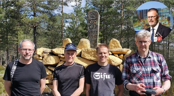
From left: Martin Lidberg, Sweden, Tor Erik Bakke, Norway, Dan
Norin, Sweden, Anders Østeraas, Norway and Mikael Lilje, Sweden in
the right corner
This article in .pdf-format
(13 pages)
This paper was presented at the FIG Working Week 2025
in Brisbane Australia. See and read the presentation
here
SUMMARY
The national boundary between Sweden and Norway is about 1634
kilometres long and it is the longest national boundary on land in
Europe. The boundary is mentioned already in the 11th century and
treaties from the 17th and 18th centuries are still the basis for
today’s modern definitions. It is marked by over 600 about 1.5 metres
high stone cairns. Almost 300 of them were erected already during the
18th century and they are in that sense true cultural heritage. In
addition, other boundary markers are also used, such as sign posts where
roads and hiking trails cross the boundary. There is also a
five-metre-wide clearing along the boundary.
Since the 18th century, reviews of the national boundary between
Sweden and Norway have been carried out with an interval of about 25
years. For the most recent review conducted 2020–2024, the Swedish and
Norwegian governments appointed boundary commissions in each country.
The Swedish commission is situated at Lantmäteriet (the Swedish mapping,
cadastral and land registration authority) and the Norwegian one is
situated at the Norwegian Mapping Authority. The 2020–2024 review was
performed in good collaboration between the two nations. The purpose of
the review is to provide an up-to-date and orderly documentation of the
boundary and how it is marked. The boundary markers have all been
restored, painted yellow and measured with GNSS and network RTK. The
five-metre-wide clearing has been secured (below the tree line) and made
free of trees and shrubs. The work has especially in uninhabited
mountainous areas been a challenge both logistically and physically.
In some places, the stretch of the boundary has had to be clarified
or slightly changed. These locations are mainly located on the southern
part of boundary, where it occasionally passes through lakes and along
watercourses. The clarifications especially in lakes are important for
the documentation of the review. The main source will be a digital file
with all information of the boundary, together with coordinates and
their locational uncertainties. The documentation of the review is about
to be submitted to the Swedish and Norwegian governments and it has been
a privilege to work with such a peaceful boundary.
1. HISTORICAL BACKGROUND TO THE SWEDISH-NORWEGIAN NATIONAL BOUNDARY
Sweden and Norway are situated in the northern part of Europe and the
national boundary on land between them is about 1634 kilometres long.
The boundary is the longest national boundary on land in Europe and it
is mentioned as early as during the 11th century in the saga of Saint
Olaf. The process of international boundary making consists of
delimitation and demarcation (Srebro (ed.), 2013). The stretch of the
boundary between Sweden and Norway started to be more formally defined
in the 17th century. The southernmost section of the boundary, about 30
kilometres long, was established in 1661 through something called the
Nasselbacka treaty, but no demarcation was done by that time. The treaty
was signed by Sweden and Denmark-Norway according to the peace in
Roskilde in 1658.
The remaining part of the boundary is dealt with in the detailed
Strömstad treaty from 1751, which also is a treaty between Sweden and
Denmark-Norway. This treaty, incidentally, also deals with a large part
of the current national boundary between Norway and Finland. During the
boundary demarcation that followed 1752–1766, 349 boundary markers were
erected. The main part of these markers consists of about 1.5 metres
high stone cairns. Centred in the cairns are flat stones vertically
erected, bearing engraved royal monograms of the Swedish King Adolf
Fredrik and the Danish-Norwegian Kings Fredrik V (monograms from
1752–1765) and Christian VII (monograms from 1766), see Figure 1.
The tri-state point between Sweden, Norway and Finland was
established in 1809, when Finland no longer was a part of Sweden. A
stone cairn was erected at the site in 1897–1898 and it is located
between boundary marker no 293 and no 294. The cairn at the tri-state
point was re-built in 1926 and then given a concrete layer. A few stone
cairns were also erected during the 19th century along the so far
unmarked southernmost section of the boundary.
The landscape along the Swedish-Norwegian boundary varies from deep
forests to mountainous areas high above the tree line. There are a lot
of lakes and creeks in the area. Occasionally along the southern part of
the boundary, the boundary line passes through some of these lakes and
runs along some of these creeks. The boundary line is otherwise defined
as straight lines between the boundary markers. According to the
Strömstad treaty from 1751, there should also be a 16-cubits-wide
(approximately 10 metres) clearing along the boundary line (below the
tree line) that should be free of trees and shrubs.
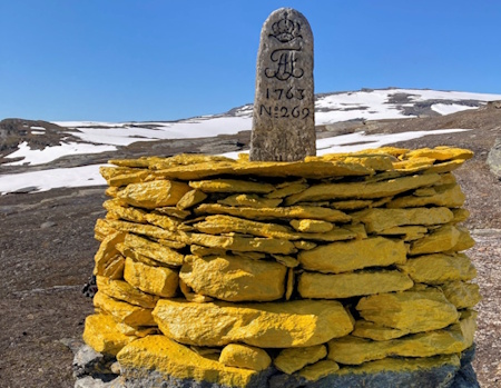
Figure 1: The main part of those boundary markers that were erected
during the 18th century consists of about 1.5 metres high stone cairns
with flat stones with engraved royal monograms. The Swedish side bear
the monogram of King Adolf Fredrik, as here on boundary marker no 269.
2. MANAGEMENT OF THE SWEDISH-NORWEGIAN NATIONAL BOUNDARY
There is a long-term perspective in the Strömstad treaty from 1751 in
the sense that it states that the markers on the national boundary
between Sweden and Norway should be maintained on a regularly basis. It
is also stated that the boundary clearing should be kept open. These
reviews of the boundary are after an agreement between Sweden and Norway
in 1933 nowadays carried out with an interval of about 25 years. The
work during the reviews is performed by boundary commissions, specially
appointed by the Swedish and Norwegian governments respectively. The
reviews of the national boundary between Sweden and Norway during the
20th century were carried out 1929–1930, 1959–1962 and 1984–1987, see
Figure 2.
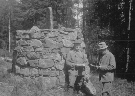
Figure 2: Captain J H von Krusenstierna and Major P A Grinaker were
Swedish and Norwegian boundary commissioners during the review of the
boundary 1929–1930, here standing in front of boundary marker no 76.
The Strömstad treaty is the base for how the work with restoring
boundary markers etcetera should be done during the reviews. After a
decision in 1957, the boundary clearing is nowadays however limited to a
width of five metres (2.5 metres into each country). The reviews are
carried out jointly by the two nations and the purpose is to provide an
up-to-date and orderly documentation of the national boundary's location
and how it is marked.
To reduce the distance between neighbouring boundary markers, the
number of boundary markers has increased significantly during the
reviews carried out in the 20th century. Some new boundary markers have
also been erected to replace creeks with straight lines. The remaining
parts where the boundary line passes through lakes or runs along
watercourses (mainly creeks) are approximately 76 kilometres long, see
Figure 3.
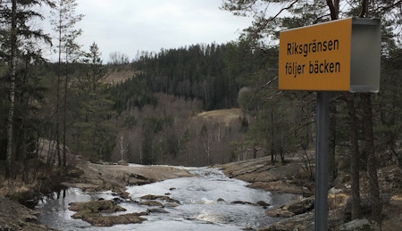
Figure 3: In some parts, the boundary line runs along creeks,
occasionally indicted by sign posts saying that the boundary line
follows the creek (“Riksgränsen följer bäcken”).
Today, the total number of boundary markers defining the boundary is
641. 610 of them are stone cairns and the remaining points are marked by
natural stones (seven of them), memorial monuments (four of them),
wooden poles with signs (19 of them) and also one steel bolt. Ten
breakpoints along the boundary line are still unmarked, mainly due to
their location in water. To better visualise the boundary line in the
terrain, several hundreds of sign posts where roads and hiking trails
cross the boundary and smaller cairns are also erected. These markers do
however not define the stretch of the boundary line. All these kinds of
markers are if needed also restored during the reviews. With a start
during the review 1959–1962, the upper part of all stone cairns has been
painted yellow.
The most recent review of the national boundary between Sweden and
Norway was conducted 2020–2024. The work has been finalised and the
documentation is about to be submitted to the Swedish and Norwegian
governments. After the submission of the documentation, the process for
the final approval of the review will start.
3. THE REVIEW OF THE NATIONAL BOUNDARY BETWEEN SWEDEN AND NORWAY
2020–2024
3.1 Organisation
The boundary commissions for the review of the national boundary
between Sweden and Norway 2020–2024 were appointed by the Swedish and
Norwegian governments in 2018–2020. Together with these appointments, a
general instruction for the execution of the review was enclosed. The
Swedish boundary commission is situated at Lantmäteriet (the Swedish
mapping, cadastral and land registration authority) and it consists of
Susanne Ås Sivborg (head boundary commissioner), Martin Lidberg
(boundary commissioner), Dan Norin (geodetic expert and secretary) and
Per Sörbom (cadastral information expert). The Norwegian boundary
commission is located at the Norwegian Mapping Authority, and it
consists of Johnny Welle (head boundary commissioner), Anders Østeraas
(boundary commissioner and secretary) and Tor Erik Bakke (technical
expert), see Figure 4.
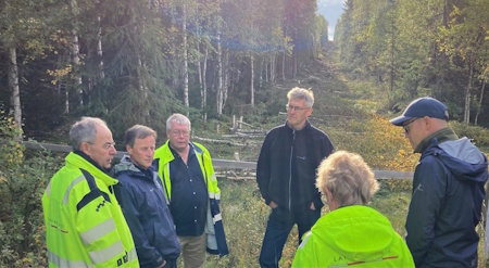
Figure 4: The members of the Swedish and Norwegian boundary
commissions standing in the five-metre-wide clearing along the boundary
line close to boundary marker no 192.
Resources from Lantmäteriet and the Norwegian Mapping Authority have
been used during the work with the review. Practically, Sweden was
responsible for the work on the northern part of the boundary and Norway
on the southern part. More detailed instructions for the field work have
jointly been worked out by the two commissions. A lot of questions of
general nature have also been treated.
Many meetings and informal contacts through e-mail have been the
ground for the good collaboration in a friendly atmosphere. Each country
has also had good opportunities to inspect the work performed by the
other side.
3.2 Field work
Since many parts of the boundary are remotely located, it was a
challenge both logistically and physically to carry out the field work.
Among the long stretches in uninhabited mountainous areas,
transportation by helicopter has been a necessity. The preparations
prior to the actual field work have been extensive. Special permits for
landing and working in natural protected areas were obtained from county
administrative boards. A continuous contact during the field work with
the local Sami population regarding reindeer farming was a necessity.
Contacts with different authorities were needed and all used equipment
had to be declared through customs control. Information in advance was
sent out to property owners along the boundary. Another challenge was to
be able work during the covid-19 pandemic, when special permissions from
authorities were needed to be able to cross the boundary.
The field work during the review of the national boundary between
Sweden and Norway 2020–2024 has been extensive, see Figure 5:
- All boundary markers and other markers were cleaned and if
necessary restored (a rough estimated is that over 1000 tons of
stones were lifted by hand).
- The upper part of all stone cairns was painted yellow (a rough
estimate is that around 3000 litres of paint have been used).
- The engraved royal monograms were filled in with black paint.
- 18 flat stones with the engraved royal monograms were found
broken and they were replaced with newly produced ones, bearing
engraved royal monograms of the Swedish King Carl XVI Gustaf and the
Norwegian King Harald V.
- Only two new stone cairns were erected, where one is a boundary
marker that defines the boundary.
- Worn out signs on signs post were replaced with new ones.
- The five-metre-wide clearing was secured (below the tree line)
and made free of trees and shrubs, where the centreline prior to the
work was staked out.
- All boundary markers were surveyed.
The GNSS-based network RTK services from Lantmäteriet (Swepos) and
the Norwegian Mapping Authority (CPOS) were mainly used for staking out
the boundary line and for measuring the boundary markers, see Figure 6.
Since mobile Internet connection was partly inexistent, post-processing
was used in these areas, either through static measurements or through
processing with virtual RINEX files. In some areas, also single-station
RTK was used. The boundary markers that define the boundary were for
redundancy reasons measured three times with at least 15 minutes
separation between each measurement.
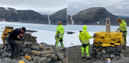
Figure 5: Boundary marker no 239a had by snow and hard weather been
destroyed including the flat stone with the engraved royal monograms and
the need for restoration was huge.
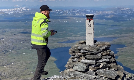
Figure 6: A small stone cairn as a boundary marker that do not define
the boundary has been erected on the highest point along the boundary
(1752 metres above mean sea level), here surveyed with network RTK by
Swedish field engineer Karl Tirén.
3.3 Documentation
The review of the national boundary between Sweden and Norway
2020–2024 is the first one where the official documentation will be
digital. All information about the boundary is available in a digital
file that is created in the format Geography Markup Language (GML). The
file will be the official documentation for public use until the next
review in about 25 years. It contains the various boundary markers with
coordinates and their respective locational uncertainties. It is also
the basis for other documentation that visualise the central information
in the GML file, such as a text-based description of the boundary,
individual descriptions with photographs of each boundary marker and
maps of the boundary's stretch in lakes and watercourses, see Figure 7.
Until now, the official source for the boundary's stretch in lakes
and watercourses has been the maps produced during the review of the
national boundary between Sweden and Norway 1959–1962. These are paper
maps with the boundary line drawn more or less with a pen with quite
large uncertainty. With the new digital representation, a large quality
improvement in the definition of the boundary line in lakes have been
achieved. The locational quality in the coordinates of the boundary
markers have through surveying also been highly improved. The locations
of the stone cairns in the terrain are however still defining the
boundary, but the description of the boundary in geographical data and
in the cadastral index maps will be highly improved through the improved
coordinates. The national boundary is according to legislation also
representing county, municipal and property boundaries. All these four
boundaries must coincide. The review of the national boundary
consequently also affects the cadastral property register.
The new digital representation of the boundary also leads to a need
for clear definitions of the boundary line in its transition from lakes
to creeks and to straight lines. Until now, both the maps showing the
boundary line in creeks and lakes from the review 1959–1962 and the text
documentation from the review 1984–1987 are occasionally a bit unclear
in this sense. Joint field visits at these locations by members of the
two boundary commissions have therefore been needed. The result is a
clear definition of the boundary in all locations. The stretches of the
watercourses have also been controlled. In a few locations, there have
been a need to define break points with coordinates and in one location
a new boundary marker that defines the boundary has been erected, see
Figure 7 and 8.
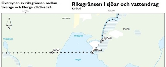
Figure 7: The boundary line goes as a straight line from boundary
marker no 52 to 52a where a new stone cairn has been erected and then as
a straight line to a point defined by coordinates (52b) in a creek,
which the boundary line from there on follows northwards.
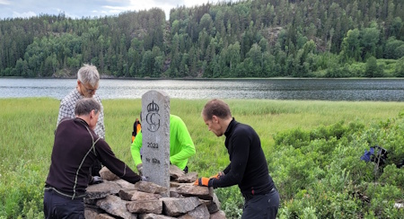
Figure 8: One new boundary marker that defines the boundary has been
erected during the review of the boundary 2020–2024. The work with
building the cairn was performed through joint efforts by Tor Erik
Bakke, Anders Østeraas, Martin Lidberg and Dan Norin from both boundary
commissions. The boundary marker is designated 52a and the location is
in a break point that so far only has been defined in earlier maps.
Boundary marker no 52 is visible on the other side of the lake in the
boundary clearing.
4. FUTURE ASPECTS
By finalising the extensive work with the review of the national
boundary between Sweden and Norway 2020–2024, the boundary line is
clarified and well-documented, which is useful for both different
authorities and the public. The old boundary markers which are true
cultural heritage have been looked after. The review also contributes in
keeping the peaceful relation between the two countries intact. With
many years to go before the next review, the goal is also to enter an
agreement of maintenance that in firsthand can enable continuous work
with the clearing along the boundary line.
ACKNOWLEDGEMENTS
The authors would like to acknowledge the employees of and short-term
engaged personnel at Lantmäteriet and the Norwegian Mapping Authority,
who have been taking part in the field work for the review of the
national boundary between Sweden and Norway 2020–2024, for their
dedicated and valuable contribution.
REFERENCES:
- Srebro H. (ed.) (2013): International boundary making. FIG, FIG
Publication no 59, Copenhagen, Denmark.
BIOGRAPHICAL NOTES
Dan Norin graduated with a M.Sc. with main courses in geodesy and
photogrammetry from the Royal Institute of Technology in Stockholm in
1991. He has during 1991–1996 and since 2002 been working as a geodesist
at Lantmäteriet – the Swedish Mapping, Cadastral and Land Registration
Authority. During 1996–2002, he was employed at the Stockholm City
Planning Administration as a geodetic expert. He holds the position as
geodetic expert and secretary in the Swedish boundary commission for the
review of the national boundary between Sweden and Norway 2020–2024.
Anders Østeraas graduated with main courses in surveying and
photogrammetry from the Norwegian University of Life Sciences in Ås
1989. He has during 1989–1990 and since 1995 been working as an engineer
at Kartverket – the Norwegian Mapping Authority. During 1991–1995, he
was employed at the municipality of Meråker as an engineer. He holds the
position as boundary commissioner and secretary in the Norwegian
boundary commission for the review of the national boundary between
Norway and Sweden 2020–2024. He also holds the position as secretary in
the Norwegian boundary commission for the review of the national
boundary between Norway and Finland to be finalised 2025 and he was also
a member of the Norwegian boundary commission for the review of the
national boundary between Norway and Russia that was finalised in 2018.
Martin Lidberg is head of the Department for Geodetic Infrastructure
at Lantmäteriet – the Swedish Mapping, Cadastral and Land Registration
Authority. He graduated with a M.Sc. with main courses in geodesy and
photogrammetry from the Royal Institute of Technology in Stockholm in
1988 and got his PhD from Chalmers University of Technology in
Gothenburg in 2007. He has worked at Lantmäteriet since 1988. He is
since 2019 the chairman of EUREF and since 2022 he is the president of
the Nordic Geodetic Commission (NKG). He holds the position as boundary
commissioner in the Swedish boundary commission for the review of the
national boundary between Sweden and Norway 2020–2024.
Tor Erik Bakke graduated with main courses in building, construction
and surveying from Narvik College of Engineering in 1981, and with
additional course in surveying from Gjøvik College of Engineering in
autumn 1984. He has from 1982 until today been working as an engineer at
Kartverket – the Norwegian Mapping Authority. He holds the position as
technical expert in the Norwegian boundary commission for the review of
the national boundary between Norway and Sweden 2020–2024. He is also
leading the field work for the review of the national boundary between
Norway and Finland to be finalised 2025 and he also participated as a
field assistant in the review of the national boundary between Norway
and Sweden 1984–1987.
Mikael Lilje is head of the International Department at Lantmäteriet
– the Swedish Mapping, Cadastral and Land Registration Authority. He has
worked for more than 30 years at Lantmäteriet, mainly at the Department
for Geodetic Infrastructure. He has also been involved in FIG for more
than 25 years and among several positions, he was vice President for the
period 2017–2024.
CONTACTS
Mr Dan Norin
Lantmäteriet
SE-801 82 Gävle
SWEDEN
Tel.: +46 26633745
Web site: www.lantmateriet.se
Mr Anders Østeraas
Norwegian Mapping Authority
Kartverket Trøndelag, Postboks 600 Sentrum
NO-3507 Hønefoss
NORWAY
Tel.: +47 32118495
Web site: www.kartverket.no
Mr Martin Lidberg
Lantmäteriet
SE-801 82 Gävle
SWEDEN
Tel.: +46 26633842
Web site: www.lantmateriet.se
Mr Tor Erik Bakke
Norwegian Mapping Authority
Kartverket Nordland, Postboks 600 Sentrum
NO-3507 Hønefoss
NORWAY
Tel.: +47 32118768
Web site: www.kartverket.no
Mr Mikael Lilje
Lantmäteriet
SE-801 82 Gävle
SWEDEN
Tel.: +46 26633742
Web site: www.lantmateriet.se


