Article of the Month -
September 2003
|
Spatial Information for
Sustainable Resource Management
Gerhard Muggenhuber, Chair of FIG Commission 3 - Spatial Information
Management, Austria
 This article in
PDF-format.
This article in
PDF-format.
CONTENTS
1. Introduction
2. Indices for Characterizing a Society
3. State of the Art of Spatial Information Management
4. How Society can Benefit from Spatial Information
5. Conclusions and Recommendations
6. Literature
This paper promotes the involvement of spatial information as an important
contribution to decision making as an integrated process within a
multidisciplinary network. Geoinformation (GI) is not any more a single
tool of a small community of Surveyors and Geographers focusing on
Spatial Information Management. GI has crossed the gap between
individuals and enterprises, but there are still some shortcomings in
using spatial information.
In the first part of the paper objectives of information management as a
contribution to sustainable development will be reviewed and the indices
for characterizing resources of a society will be identified. In a second
step the state of the art Spatial Information Management will be described
by examples. Finally the paper focuses on the impact on and benefit for
society and the surveying professions of increased use of spatial
information.
2. Indices for Characterizing
a Society
Usually people in a society are not aware of slow spatial changes over a
longer period of time and thus tools for managing spatial and temporal
information are needed. But how can those relevant spatial components be
defined and how can they be used to optimize the use of resources by a
society?
Traditional mechanism for optimizing resources may help to understand
potentials for optimizing the benefit for a society using temporal
information. A society as a compound of interrelated individuals agrees –
driven by traditional concepts - on value systems and the use of resources
to achieve defined aims for the majority of individuals. In general the
use of the various resources is first of all a decision of the society
dependent on its value system. Spatial information and GI tools are
suitable means to optimise the sustainable use of resources within a given
framework. Societies with various and diverse value systems are
unavoidable under higher social pressure. An example (Thurston, 2003) may
clarify this: It is an unspoken rewarding system in the western society
that (i) headwork is better rewarded than handwork; (ii) financial skills
are better rewarded than technical competences; (iii) management talents
are better rewarded than financial skills. Those societies with a
rewarding system in conformity with their main sources of wealth and
prosperity have a tool for optimizing their resources which also serve as
a shield against poverty. There are obviously mechanisms which facilitate
the optimizing processes in a society to improve an infrastructure.
2.1. Framework for Optimized Infrastructure
Can we derive from the general decision making mechanisms of a society the
processes for improved use of resources related to spatial infrastructure?
The general public is not much interested in technical issues and the
consequences of decision making seem be clouded in mystery.
In his book “The Mystery of
Capital - why capitalism triumphs in the West and fails everywhere
else" De Soto [de Soto, 2000] surprises with the empirically grounded
argument that "most of the poor already possess the assets they need to
make a success of capitalism. What they lack is the ability to turn their
assets into usable, mortgageable, multipliable capital…. In the West every
parcel of land, every building is represented in a property document that
is the visible sign of a vast hidden process that connects all
these assets to the rest of the economy…. The vast hidden process is the
western, legalized property system… this system is clouded in
mystery, a mystery to people in both the West and the rest of the world.”
Actually, there are some mysteries that De Soto brings to light. The first
mystery is the "lack of information." The poorest people in the
Third World do not know that they are sitting on valuable material assets.
Secondly the "mystery of capital" itself: Capitalism is what a
legal, property/contract system allows people to create values based on
their material assets. The third mystery is the lack of "political
awareness" of changes: In recent decades, people all over the world
moved to cities - a migration with implications of revolutionary
proportions that have been virtually ignored. The fourth is the “mystery
of forgetfulness” - the "missing lessons learned from history." People
in rich countries don’t even recall how their legalized property system
came into existence. Finally, the "mystery of legal failure"— why
property law does not work everywhere: Third World Countries cannot just
transfer the western legal system without linking it to their own
traditions of values. Doing so is an obstacle for creating values out of
assets.
2.2. Categories of Infrastructure
From the above-mentioned observations we can derive a list of resources
contributing to development of a society’s infrastructure. Most of these
infrastructures have a spatial component. In the following some of that
infrastructure is discussed:
-
Human resources: people contribute with handwork or headwork
-
Natural resources – these are the main resources of an agricultural or
industrial society
-
Infrastructure is a resource developed by a society over time -
infrastructures for transportation and power supply, but also
telecommunication and Spatial Data Infrastructure (SDI):
-
Information systems with applications like mapping, land register &
cadastre
-
Political framework, governmental systems
-
Legal framework
-
Administrative systems
-
Transport system
-
Communication network
-
Networks providing goods and service (stores)
-
Security System (internal/police & external/army)
-
Health System
2.3. Human and natural resources
Human and natural resources are usually finite. Sustainable
development provides a framework under which communities can use
available resources efficiently, create efficient infrastructures, protect
and enhance quality of life, and create new businesses to strengthen their
economies.
2.3.1 Human Resource for Geoinformatics
In the field of Geoinformatics training currently several policy
initiatives transcend current education strategies. New job description
will come up with specifications like: Spatial Information Officer,
Information Cartographer, Metadata Specialist (Thurston, 2003).
Surveying appears to have lower public esteem than Geoinformatics.
“I'd like to think training needs are being driven by the marketplace,"
says Kelly, Managing director of ANZLIC.
 |
Networks of universities like
UNIGIS provide a service as a global, virtual & multilingual
university for Geosciences, also working together in research and
curriculum development activities related to GIS education. Students
registered in a UNIGIS programme may qualify for the EuroMasterGI, a
European post-graduate qualification in Geographic Information. On the
other side there is simply a lack of interest amongst the student
community in surveying careers. |
Information technology has to take care of the customers as human
resources and as partners in business processes. What are the challenges
for the customers? The customers get more and more involved in the
unpleasant aspects of merging, transforming, overlaying and filtering
information. The Director of the Open Planning Project in New York, Rob
Hranac, (published in [Corbley, 2002]) commented: “GIS users spend
90% of their time searching for datasets and 10% actually using them. Can
you imagine how the industry would grow if those numbers were revised?”
A sound information infrastructure needs more than data. There is urgent
demand for harmonization of services and data for optimised common
use. There is no direct contact any more among creator, provider and user
of spatial data. Therefore data need not only standardized geo-referencing
in order to provide a clear link to administrative units, addresses or
other specific geographic units. There is an increasing demand for
metadata on spatial information. Librarians have been producing and
standardizing metadata for centuries. The spatial information managers
have to do the same for easier access to all the spatial information
created.
2.4. Information as a Driving Force
The driving force behind economic development depends on the focus of a
society. In Europe the transformation from an industrial to an
information society became obvious during the recent thirty years. The
industrial society needed access to steel and coal - both together
were forming the bases for industrial development. The
European Coal
and Steel Community (ECSC) of 1952 was an essential root of the European
Union and expressing herewith the industrial background. Nowadays in our
information society people are often not yet aware of the new demands on
infrastructure, when changing their main source of income from producing
industrial goods to a service oriented “knowledge economy” based on
information and communication technology (ICT).
Data and ICT are the driving forces behind an information society. So it
doesn’t surprise that at the end of the 20th century the focus was on
digitising data and on building infrastructures for accessing these data.
The next wave might come from integrated services as driving force behind
our society. According to the Kondratieff Cycle (Nefiodoff,
2001 and
Alexander, 2002) the next wave will focus on the ability to cooperate,
which seems to become the key qualification for increasing productivity.
This means: Information becomes interrelated.
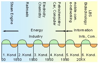 |
The Kondratieff Cycle is a theory based on a study of
nineteenth century price behaviour in the US. Kondratieff observed
certain characteristics about the growth and contradictory phase within
long-term periods (which averages 54 years in length). It can be
concluded that there is a systematic structure behind periodically
behaviour of economy. |
2.4.1. Information for Decision Making
Good decisions are based on good information. Good information is
based on good data. Planning, shaping and modelling of proposed plans
are parts of information management which became a fully digital process.
The demand for spatial information for decision-making can be considered
from different perspectives. First and foremost, the process of
decision-making requires information as an input (informed decisions).
Secondly spatial information is needed for impact analysis. As is well
known, decisions have a range of immediate up to long term impacts. In all
cases, the consequences of decisions must be predicted and controlled.
Especially development processes require monitoring and evaluation of the
decision’s outcome. This is the reason why the increased need for spatial
information is becoming a challenge for people who are involved in decision
making with spatial components.
Data collection and data analysis have contributed to an improved
understanding of social and environmental impacts on planning and
development actions. With new surveying, communication and information
technologies decision-makers have more spatial information and thus
accountability on the interrelationship of communities, impacts and effects
of decisions. Finally the decision-makers have a powerful instrument for
future developments.
2.4.2. Information as Part of an Infrastructure
It is not just about the availability of information but we also need
links as a bridge from existing knowledge to new information. Information
exchange as a process enables humans to share and acquire knowledge from
others. Information technologies (IT), developed to support information
processes, are still designed to operate within established structures of
closed systems. In order to overcome the barriers of closed
communication cycles and to grant wider access to knowledge, it is not
sufficient to deliver data. There is a demand for information entities
containing indicators for potential common interests, values, interpretation
patterns including rules for intended goals. New knowledge can only be
achieved when incoming information can be linked to existing knowledge.
Therefore a different view on information results in a different knowledge,
which also depends on existing knowledge. Spatial Information services have
to consider the users perception.
2.4.3. The Value of Information
In business world surrogates are often used because we have no access to
the original. The ownership title is such a wildcard. Information as a
wildcard allows us to model a “virtual world” for orientation and
decision-making. Thus information allows a remote observation of space and
time in a way we could not do otherwise – like environmental scenarios.
What kind of information infrastructure is needed to let these mechanisms
work? The recent introduction of the Euro increased the awareness for the
demand of integration of individual, fragmented markets into a joint
European one. Some of the lessons learnt may also be helpful in a
knowledge-based economy for introducing information as a surrogate (of given
values) for facts proved or collected. This applies for the land market
and the ensured information on property in the same way as for spatial
information in general.
2.4.4. Political System as Framework for Sustainability
In most countries, the idea is that the government will tell you what is
good for you. However sustainable development can only be achieved by
creating trust in the approach of a society in general. Participatory
democracy, decentralisation and community empowerment can support such a
sustainable development in a society. The practice according to
Ian Bremmer
from the consulting business is still that development is linked to
individual politicians rather than with the whole society: “Investors are
starting to understand that economic reform depends on the politicians
promoting it, remaining in power.”
Decisions are made at different administrative or organisational levels.
Nowadays, there is a global tendency to decentralize decision-making
and delegate responsibility to regional or local authorities or
organizational units. As a result, the number of points where decisions are
made has been increasing and this leads, among other things, to a greater
need to share geoinformation.
Modern governance requires transparency and the involvement of
communities and citizens in the decision making process. Decentralisation
and community empowerment are strategies to achieve transparency and
participatory democracy. This also applies for community based land
management processes in particular and development administration in
general. Modern spatial information management tools facilitate
decentralisation, community empowerment, and citizen participation, which
guarantee social cohesion and sense of belongingness.
2.4.5. Legal and Administrative System
The legal system, especially the property laws of a country reflect the
rather sustainable concept in people’s minds. In Europe most of the land
administration systems were created for tax purposes and have their roots in
an agricultural society.
The legal system has an essential impact on the use of spatial
information:
- a sustainable land market is based on secured Property Rights and
access to relevant public information for Government and citizens,
- a legal framework established to secure the Intellectual Property
Rights are an essential component of an information market. Market
distortions deriving from a high percentage of misuses – like in music and
software industry - would have a negative impact on use and trust in
spatial information.
- Data Protection legislation protects individuals against abuse
of information based on an understanding of the national security issues,
but has an impact on access to information.
 |
The Bathurst
Declaration on Land Administration for Sustainable Development
(Bathurst, 1999) calls for a commitment to provide effective legal
security of tenure and access to property. It identifies the need for
the promotion of institutional reforms to facilitate sustainable
development and for investing in the necessary land administration
infrastructure. It recommends the active participation by local
communities in formulating and implementing the reforms, and it sees an
increasingly important role for IT in developing the necessary
infrastructure and in providing effective citizen access to it. |
2.4.6. Land as a Multipurpose Resource
The market value of land is no longer derived from agricultural benefit,
but increasingly interesting for industrial use, for urbanization and as a
resource for transport systems. All of them offer higher prices than the
agricultural land market. The land market became distorted – rules for use
(land use planning) have been developed. Even in a post industrial society
real property rights are one of the cornerstones for the land market - a
driving force for economic development based on four pillars.
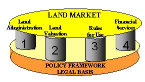 |
Figure: Four pillar-model of the Land Market - based
on three pillar model of (Dale, 1999). |
2.4.7. Rural Resources for Urban Development
There is a global trend of migration from rural to urban areas because
urban environment seems to offer better jobs, income and infrastructure. The
urban-rural conflict becomes visible in the slums and suburbs. More and more
rural resources are used for urbanization: human resources as well as land
are used for urban development. Human resources become a main part of urban
economy. On one side the “brain-drain” is a hindrance for rural development
– on the other side the rural regions serve as buffer for economic
fluctuation as long as there is a rural infrastructure to which people can
come back.
The United Nations estimate that by 2025 54% of the world’s 7.8 billion
population will be living in urban areas. The percentage is higher in the
developing countries which also results in a breakdown of the transport
system. “We have to change the way we move ourselves if we are to avoid
the gridlock of environmental degradation brought out by transport” said
Kurt Hoffman, director of the London-based Shell Foundation.
Statistical data point out rural areas as multidimensional reserves
for human resources that are needed for urban development. Human
resources and human knowledge are some of the most important resources
for sustainable development all over the globe but especially in
high-industrialised countries. The globalisation of economy and the
complexity of global ecology need experts. The high-industrialised countries
have met this need within the last decades and consulting services,
education and training became substantial export articles to developing
countries.
2.5. Land and Water Resources
Land serves as living environment and as a base to fulfil the various
human needs with three main functions (Banko
& Mansberger, 2001): (i) economic, (ii) social and (iii) ecological
functions, whereas the priority setting of functions characterises a
society.
2.5.1. Land as Economic Resource
Beside capital and labour land is one of the classical production factors
of an economy. It can be seen as a product itself or as a mean for producing
other goods. The land market has some specifics: Firstly, the supply of land
is constant within a region. The concept of the free-market system that
supply of goods (land) can be increased works only for some branches of the
land market - e.g. the supply of building land can be increased by
modification of zoning. Secondly, land is not a homogeneous product: Parcels
differ e.g. in regional sites, in the degree of existing infrastructure, in
soil quality. So each parcel is not fully substitutable. Land and water are
a basic necessity for the food industry, for energy resources (e.g. oil,
coal, water) and for the cultivation of renewable resources (e.g. wood).
2.5.2. Land as Social Resource
All non-economic benefits for human beings from land can be summarized as
social resources of land. These aspects include the function of land to
regulate the climate and the water supply as well as the purification of air
and water.
Land often has an emotional component for its residents. The
region of birth often is seen as homeland. Many military conflicts were
justified by claims for the same region by different nations. But land also
is an inspiration medium for artists. The beauty or the specific landscape
of a region often are the catalyst for the composition of paintings, poems
or music.
The function to reduce noise emissions becomes increasing
important in densely populated areas or areas with a high rate of traffic.
Considering the protective function for human beings, land plays a
schizophrenic role: Besides of the climate conditions, the specific
topography of land is the reason for most natural disasters, e.g.
avalanches, floods or landslides. On the other hand land can protect people
from natural risks – once again due to its specific topography. Thus
information about land becomes an important part of modelling and
planning within the frame of disaster risk management. The following
example clarifies the potential role of spatial information within
disaster risk management: The Government of India and UNDP started a
joint Natural
Disaster Risk Management Programme under which a database for disaster
risk management and sustainable recovery is built.
2.5.3. Land as Ecological Resource
The ecological function of land in terms of climatic change and
conservation of natural resources and biodiversity has received increasing
attention by the international community (UN 1992; UNFCCC 1992, 1998).
International agreements address the requirements for the functioning of
ecosystems. As a consequence of that many worldwide and national initiatives
focus on awareness of biological and diversity issues. Landscape is
recognised as a unique mosaic of biotic and abiotic features (for example:
cultural, natural or geomorphologic features). It is recognised that the
change in land use practices is important factors for both biodiversity
and diversity of landscapes, which again asks for modelling tools of
spatial information.
3. State of the Art of Spatial Information Management
3.1. Thirty Years of Spatial Information
Looking back at the history of Spatial Information Management shows the
progress made and better explains the current challenges as well as next
steps to be taken.
Thirty years ago we learned about GIS. We focused on implementing and
tuning a stand-alone tool - a unique GIS-package adapted to the internal
needs of a company. We were happy to ride the horse and accepted frictions
caused in our production processes.
Twenty years ago we were focusing on digitizing data – everything had
to become digital. We stuffed our information into bits and bytes. Everybody
did it his own way, which turned out to be a hindrance for data exchange.
Ten years ago we realized that we did similar things and needed to
share data. We realized that frictions in sharing information are not only
caused by data, but also by institutional settings.
Nowadays we try to improve our institutional setting by cooperation –
some even by merging organizational unit, but there is always an additional
organization to cope with – so cooperation is needed anyway.
During these years our focus has been shifting from hardware and
software (“How to use GIS?’)
· to data acquisition (“From were to receive more data?”),
· to data quality (“Why all these different data do not fit?’),
· to data integration (“Why did you use a different reference model
?”) and
· to process integration (“How can multi-institutional cooperation
provide a better service?”)
As a result from that a lot of effort are necessary for standardization (ISO-TC211,
OGC and within all the GIS-companies,
GSDI,
EU-INSPIRE), but still there are frictions.
3.1.1. Cooperation Forced by Technical Improvements
Within the last decade a lot of changes have took place in the field of
data collection, data processing and equipment (GPS, laser-scanning, digital
imaging and image processing). The development was mainly technology
driven. Thirty years ago surveying equipment got an innovative push by
the computer technology. The competition on new technologies led to the
merging of companies and partnerships between companies. At the
beginning of this process companies of similar profiles merged (like Wild
and Kern). Later on companies of rather different backgrounds also merged.
Surveying equipment met software (Leica, Helava, System9). Nowadays
cooperation is seen under a wider perspective (e.g.
Partners of Leica) and goes beyond the approach to integrate software
into some hardware (surveying equipment).
It seems that the business models changed. The change from supply
to demand driven developments, products and services requires the
involvement of heterogeneous expertise. Therefore a flexible cooperation can
bring more benefit than just merging companies, which caused many frictions.
The next step of this business approach resulted in combining tools used in
that process e.g.: “Total Management Systems for Real Estate” with GIS
(e.g.:
SAP and
ESRI).
Technology empowered individuals and local communities to create
their own IT-solutions with integrated tools for spatial information
management. While the amount of digital spatial data collected at the local
government level is dramatically increasing, but little is incorporated in
the public domain. This development might still be rather an opportunity
than a threat. One day all these data can contribute to aggregated
information as a result of an integrated, well coordinated approach to
spatial information.
3.1.2. Cooperation Forced by Economic Pressure
In the past technical development of equipment resulted in a faster and
more cost-efficient data production. In the next step improvements focused
on optimised production processes within individual companies. In the
meantime organizational improvements can be obtained by streamlining
procedures as inter-institutional “Clustering” processes.
The increased financial pressure on public institutions as well as on the
private sector forced the process of rethinking their business models.
Duplication of work is not affordable any more. All kind of outsourcing
became fashionable e.g. acquisition and maintenance of spatial data.
Traditions were given up in favour of process oriented cooperation along the
chain of added value and led to clustering (www.giscluster.at).
Whatever can be provided by somebody else in a more efficient way is
preferable to in-house solutions. That situation calls for partnership and
teamwork across disciplinary lines, bridging different commercial sectors,
which is also an opportunity for local communities: “Paradoxically
the lasting competitive advantages of a global economy are increasingly
focusing on local conditions – knowledge, partnerships, motivation:
components which hardly can be reached by afar rivals” according to
[Porter, 1998].
3.2. Good Practice
There is a growing number of applications and services utilizing spatial
data to provide business solutions in government agencies, business
enterprises and the communities such as
emergency
management, disaster risk management,
natural
resource management,
land
administration,
environmental
monitoring,
health,
geo-marketing,
routing,
tourism and
finance.
Data policy, institutional framework, technology and standards are emerging
as the four major pillars of a spatial data infrastructure. The following
examples provide some overview of activities:
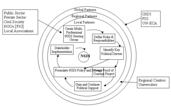
Fig.: Iterative process for achieving NSDI [FIG Publ.30]
3.2.1. Awareness of Spatial Information Policy
The Europe, Asia and the Pacific and America are actively involved in
coordinating the development of a Regional Spatial Data Infrastructure:
There are also attempts to establish a
National Spatial
Information Framework (NSIF) in Africa.
3.2.2. Standardized Spatial Information on Global Level
The global user community for spatial information standards consists of
nations, non-governmental organizations, such as the United Nations,
multilateral banks and international initiatives and programmes.
International Organizations facilitate the use of spatial information from
rather different angels. Improved solutions through standardizations,
development of integrated services and cooperation are supported by
organizations such as:
 |
International Organization for Standardization (ISO) TC-211 aims at
establish a structured set of standards for information concerning
objects or phenomena that are directly or indirectly associated with a
location relative to the Earth.
OpenGIS Consortium (OGC) -
specifications support interoperable solutions with "geo-enabled"
web-tools and location-based services to make complex spatial
information and services accessible and useful for other applications.
World Wide Web Consortium (W3C)
develops interoperable technologies to lead the Web to its full
potential. W3C is a forum for information, commerce and communication. |
3.2.3. Spatial Information Policy on Global Level
Many international organizations address the issue of spatial
information, acting as opinion leaders, policy makers as well as providers
of economic, environmental and financial data – all of them interrelated
through spatial information. Some interested links are given:
 |
UN-HABITAT runs two major worldwide campaigns – the Global
Campaign on Urban Governance, and the Global Campaign for Secure
Tenure. UN-HABITAT is monitoring global trends and assesses the
progress of implementing the Habitat Agenda by two main instruments:
Global Urban
Observatory and Statistics and
Best Practice Database.
UN – FAO has launched special activities and programmes to mobilize
governments, international organizations and all sectors of civil
society in a coordinated campaign to eradicate hunger and to turn the
slogan “Food for All” into reality. FAO - publications related to
Spatial Information:
|
 |
Two Wold Bank publications on resource management and spatial
information:
|
3.2.4. Spatial Information – Activities on Regional Level
Integrating tools for a joint information infrastructure is a long
process similar to the political decisions in Europe to establish an
integrated economy. The decision on a common currency was made in the
1950´ies and needed 50 years for implementation. The strategy decision on
telecom liberation showed good results within 10 years. Telecom and wireless
internet are tools needed to set up Tele-cartography and Location Based
Services. The increasing integration of the European economies led to an
increasing demand for pan-European information products. Activities for
geoinformation in Europe started with strategies, but focus more and more on
a practical approach:
 |
The EU-INSPIRE Project is a
triggering force for a joint European action on spatial data
infrastructure in practice. A coordinated decentralized approach
should ensure a flexible solution based on information to be summarised
for implementing and monitoring policies of decision-making (regional,
national and community).
The EU-EULIS project within the
eContent-programme aims at establishing a European Land Information
Service by accessing national land information across borders via the
Internet. |
In 1999 the EC published a Green Paper on “Public
Sector Information”. In 2001 a “White Paper on Governance”
announced that all EU-legislation will be accessible for free on the
Internet in all the Union languages through the EUR-Lex portal. In 2001 the
EC has launched “eEurope
2002: Creating a EU Framework for the Exploitation of Public Sector
Information” which focuses on the economic aspects of public sector
information.
 |
The right to re-use public sector information will support the
growth of the European Content Markets similar to the US where the
reuse of public sector information has given way to an information
market that is up to 5 times the size of the EU market (Spira-Study,
2000). Europe is seeking for a balance between initiating market growth
and charging for public sector information on the way to a knowledge
economy. The key factor for success seems to be the joint interest
of partners involved based on economic factors as driving force for
improved services. |
3.2.5. Spatial Information on National Level
 |
The vision of the
Spatial Information
Council for Australia and New Zealand (ANZLIC) is that economic
growth, social and environmental interests are underpinned by spatially
referenced information. ANZLIC's facilitates easy and cost effective
access to spatial data and services provided by a wide range of
organisations in the public and private sectors. |
In the United States the
Federal Geographic Data Committee (FGDC) is developing the National
Spatial Data Infrastructure (NSDI) in cooperation with organizations from
State, local governments, the academic community, and the private sector.
The NSDI encompasses policies, standards, and procedures for organizations
to cooperatively produce and share geographic data. The goal of this
Infrastructure is to reduce duplication of effort among agencies, improve
quality and reduce costs related to geographic information.
In Canada
GeoConnections a national partnership initiative is working to build the
Canadian Geospatial Data Infrastructure (CGDI), which will make Canada's
geospatial databases, tools and services readily accessible on-line.
3.2.6. Cooperation on Spatial Information on Operational Level
- “The GeoData Alliance (www.geoall.net/)
is an innovative, non-profit organization open to all individuals and
institutions committed to foster processes to enable the creation,
effective flow, and beneficial use of geographic information.
- In Austria the GIScluster (www.giscluster.at)
is a fusion of companies that offer a broad selection of know-how and
services along the chain of added value. This interdisciplinary
cooperation within the business of ‘spatial data management’ includes
acquisition, management and the visualisation of data.
- The ‘Three Ordnance Surveys’ of Great Britain, Ireland and
Northern Ireland cooperate on building and maintaining national databases
[Murray et al., 2001]. They intend in the long run standardisation of
data, structures, identifiers and formats.
- The Austrian software company Progis (www.progis.com)
is applying new approaches to ‘Precise Agriculture’. Their
decentralized approach of shaping the business procedures supports the
dataflow between farmers and the regional agricultural administration
centers to be used also for updating. Updating has to involve the farmer,
who knows about the actual changes in the field.
- An other good example for an integrated approach comes from Canada:
The “Land and Water
British Columbia Inc.” under the “Ministry of Sustainable Resource
Management” is responsible for land issues but also for
Water Licensing,
Water Use Planning,
Water Resource Information.
4.
How
Society can Benefit from Spatial Information
4.1. Benefit or Threat for Educational System
New tools and methods for learning came on the market during the last
years to support knowledge transfer and to enable virtual lecture rooms.
Will that change the whole educational systems? Can they substitute
traditional lecturing or replace the teachers? Questions that cannot be
answered yet, as the access to electronic media is the limiting factor for
this new technology at the moment: 50% of the population of North America
are able to surf in the Internet, whereas only approximately five percent
population have access to Internet. But there is no doubt that e-Learning
brings about new opportunities for knowledge transfer – also in terms of
life long learning.
The use of spatial information technologies is providing substantial
economic, legal and political advantages. Possession of spatial information
has also contributed to military power. We need to reflect on the
potential significance of technological and institutional changes for the
widening or lessening of social and economic gaps in society.
Traditionally intellectual and emotional engagement is attached to a
certain location. These place-based communities are increasingly being
complemented by virtual ones where people ‘meet’ and become involved with
others without regard to distances. The risk that Internet accelerates the
detachment of individuals from the places within which social networks are
formed is balanced with the opportunity to interact with self-defined
communities electronically in response to exclusion from local communities.
As people transfer more of their time and loyalty from actual to virtual
communities, the balance between place-based and non-place based
communities is shifting, with potentially wide-ranging implications both
for places and communities, and for the influence of place on individuals
(Goodchild et al., 1999, - Varenius-Project). This development might be a
disadvantage for the communities in rural areas.
4.2. Knowledge is Information in Action
The question is about combining multi-source spatial data with
processes into usable information products. It is all about
maximising the economic, social and environmental benefits from
investment already having been made in spatially referenced information. The
realisation is based on at least three components: data, processes and
knowledge. Progress has been made to improve the procedures of spatial data
acquisition, but the real challenge is the workflow:
- to organise business processes that support the availability
of, and accessibility to geo-information in the right place, at the right
time and for the right person;
- to create and maintain data models and databases from which
information can be extracted, processed and shared by many stakeholders at
any given time.
How can we deliver the right information to the right people at the right
time, if the right information must be derived from here-and-now parameters
that change daily? The answer comes from business model innovation. In other
words: the result of human activities on different locations is an
integral part of information required and should be considered as part of
our modelling processes.
4.3. Changing Role for Surveying Profession
Finally the role of the surveyors will not stay untouched by the modern
information management including data acquisition methods and distribution
technologies for streamlining inter-organizational workflows. Surveyors have
to develop from pure data collectors to information managers.
In the past dramatical changes in our geodata business derived mainly
from technological innovations. In the meantime however changes are more and
more caused by improved business processes with a sever impact on our
surveying business. Some of our customers and even some partners like
National Mapping Agencies started innovative reorganization processes, which
had some drawbacks:
- Reorganization takes time and resources – during that time customer
contacts are weakened.
- The renewed organization may again not fit because the business world
is changing constantly.
Even running the traditional “change script” faster does not work.
The reaction to increased business pressure with organizational changes
often is the wrong way. The most dynamic firms shift business models
without organizational changes. Instead of shifting organizational blocks we
have to shift mindsets!!!!
|
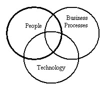
Fig. Integration of processes.
|
Some decades ago the strong position of surveyors with almost a
monopoly in geometric data acquisition was mainly based on
technology and people - technological innovation combined with highly
skilled experts. In the meantime technology became cheaper and easier in
its use. This led to a wider user community: thematic experts acquire
geodata themselves. This trend was increased by another change: Geodata
became more detailed in their “thematic resolution”. The required
knowledge for geodata assessment shifted from geometric to thematic
issues with the consequence that thematic experts are more involved in
data acquisition than surveying experts. |
But nevertheless surveyors are needed more than ever. The merging of
global geodata requires well-based knowledge about coordinate systems and
map projections. In the future four additional main activities have to be
realized by professional surveyors in the field of “Spatial Data
Management”:
- Coordinator of the workflow for geodata sets
- Information Manager (including documentation: metadata)
- Quality Manager (QM) for geodata
- Expert for integrating business data, thematic data and geodata across
different professions to generate “geoinformation for decision making”.
Or with other words: the surveyors have to mutate from “Geodata
Collectors” to “Managers in Geodata Clusters”. The training and
communication of these skills and the understanding of demands and language
of other professions will be essential for the success as a surveyor.
Surveyors, who contribute to the consulting business, experience already
today the wide range of skills and inter-professional cooperation needed.
The interval for launching new products will increase and business models
have to be adapted to the faster and more automated sampling of geodata. The
trend to lower costs for surveying and data capturing will continue.
Due to the broad thematic orientation and huge amount of geodata needed
for a wide spread field of users the organisation of data acquisition
requires new strategies. Co-operations and partnerships of companies and/or
institutions on a local or regional level (Public/Private Partnerships) in
so-called “Geodata Clusters” could be the key development. “Geodata
Clusters” will need a core group for the managing of geodata: Surveyors with
their education and knowledge of geodata management have to take this
position: Providing service for our customers and bridging contributions
from different professions. From that point of view I wonder how long it
will take national surveying associations to open up their communication
to other professions e.g. by organizing cooperations for developing a
better service to the customers.
There is a strong need for Spatial Information for public and
private decision-making
Decision-making for improved use of limited resources is highly related
to spatial information. Especially the basics of geoinformation (links
between men and land) should be maintained countrywide to enable and
guarantee unobstructed common and personal welfare.
Good Governance requires affordable integrated solutions for
access and use of geodata for an increasing number of users.
New Technologies opens opportunities to acquire more and detailed data
in a shorter time and enables real time access to geoinformation for a
nearly unlimited number of users. Within the last years powerful tools for
the storing and processing of geodata appeared on the market. However new
systems are still not affordable for local governments and communities in
many countries. Policies and strategies are necessary to make new
information and communication technologies accessible to poor people too.
Decentralisation and Community Empowerment require Spatial
Information Experts at local level.
The use of geoinformation resources requires knowledge at a local
level about data acquisition, data processing, and the visualisation
of data. The degree of geoinformation expertise is varying and depending
on the responsibility of a specific person or user group.
Decision-makers need another education and training programs in
information technology than people involved in the implementation or
maintenance of IT systems or specialists for data capture. Policy has to
focus its activities on capacity building in the broad field of
geoinformation technology.
Sustainable development requires information exchange between
different levels of public and private institutions.
The use of clearly defined standards facilitates the sharing and
exchange of geoinformation amongst various user groups. But the increasing
number of collected and available geodata also requires a detailed
description of the data, the so-called metadata. Metadata in the context
of SDI facilitates access to data and can also prevent duplications that
may arise from limited knowledge of available data residing at different
locations.
Implementation of spatial data infrastructure requires cooperation
between the private and the public sector and amongst all professions
involved in land management.
Land registers and land cadastres as part of SDI mostly are the
responsibility of public authorities. But decision-making processes demand
additional thematic information about land collected and maintained by
various public or private institutions or by professionals trained in a
particular trade. Partnership and cooperation among all groups is
necessary for successful geoinformation management.
Spatial Information is an essential part of the infrastructure
in a country.
The acquisition and maintenance of geoinformation itself seldom is a
cost-covering activity in a country. But the availability of
geoinformation has positive impact on public as well as private business
and welfare with consequences for the national economy. The creation of a
countrywide SDI must be a primary objective at all levels of
administration.
Decentralisation and Community Empowerment require a specific
geodata policy.
As shown above various private or public users on different levels of
administration require spatial information for decision-making – often
based on the same geodata. The number of units involved with geodata
management is increasing with the degree of decentralization. To avoid
redundancies and inconsistencies in the collection, storage, maintenance
and the distribution of geoinformation, policy has to provide the legal
and the administrative framework as well as the business environment
to clarify the responsibilities of various actors involved in geodata
management. The regulations have to include detailed specifications in
terms of the tasks for the units, in terms of the topics of data, and the
defined working areas. Geodata policy also has to coordinate strategies
for the integration of procedures within spatial information management.
Alexander M. (2002):
The
Kondratiev Cycle: A generational interpretation. ISBN: 0595-21711-7,
Published by iUniverse.com, 2002.
Badhurst (1999):
The
Bathurst Declaration on Land Administration for Sustainable Development.
Published by The International Federation of Surveyors (FIG). ISBN:
87-90907-01-9, Dec 1999, Frederiksberg, Denmark.
Banko G., Mansberger R. (2001):
Assessment of "Non-Monetary Values of Land" for Natural Resources Management
Using Spatial Indicators. In: Njuguna, H., Ryttersgaard, J. (Eds.):
Proc., International Conference on Spatial Information for Sustainable
Development, Nairobi, Kenya, 2-5 October 2001; FIG Commission 3, 310-322.
Corbley, K.P. (2002):
The GeoData
Alliance: A New Hope. Reprint from GEOWorld July 2002., (2002).
Dale P. (1999):
Is technology a blessing or a curse in land administration?. UN-FIG
Conference on Land Tenure and Cadastral Infrastructure for Sustainable
Development, Melbourne, Australia, Oct. 1999.
FIG PUBLICATION NO. 30:
The
Nairobi statement on spatial information for sustainable development.
FIG in co-operation with the United Nations, ISBN: 87-90907-19-1
Frederiksberg, Denmark 2002.
FIG PUBLICATION NO. 31:
Land
Information Management for Sustainable Development of Cities - Best
Practice Guidelines in City-wide Land Information Management. FIG in
co-operation with the UN-HABITAT, ISBN: 87-90907-21-3, Frederiksberg,
Denmark 2002.
Goodchild, et al. (1999):
Introduction to the Varenius-Project, International Journal of
Geographic Information Science, 13(8): 732-745, 1999.
Mansberger, R. (2003):
Geoinformation in Support of Decentralisation and Community Empowerment.
Proceedings of the Third Meeting of the Committee on Development Information
(CODI). United Nations, Economic and Social Council - Economic Commission
for Africa. Document Nr. E/ECA/DISD/CODI.3/27. 10-16 May 2003. United
Nations Conference Centre, Addis Ababa.
Muggenhuber G. (2003):
Geoinformation in optimized Business Processes. FIG Working Week,
Paris, 2003.
Murray, K. (2002): Bray, C.: Better connected: the three Ordnance
Surveys improve georeferencing links. Proceeding of the AGI Conference
at GIS 2001. United Kingdom 2001.
Nebert, D.(2001):
The SDI
Cookbook, GSDI-Publication, 2001
Nefiodow L.A. (2001),
Der
sechste Kondratieff, ISBN: 3980514447, Oct.2001.
Porter, M.(1998):
Competitive Advantage: Creating and Sustaining Superior Performance.
Free Press, 592 pages, ISBN: 0-684-84146-0 (1998).
Study for the EC by Pira International on commercial exploitation of
public sector information, October 2000
Thurston J. (2003): The New
Geo-Jobs, a second look in the New Millenium. In:
geoinformatics.com, Vol.6/2003, ISSN 13870858.
World Bank (2002):
Land
Policies for Growth and Poverty Reduction, ISBN: 0-8213-5071-4,
Washington 2002. |