Article of the Month -
May 2010
|
Spatially Enabled Government and Society -
the Global Perspective
Abbas RAJABIFARD, Australia
 This article in .pdf-format
(9 pages and 88 kB)
This article in .pdf-format
(9 pages and 88 kB)
1) This paper has been presented as a keynote
presentation at the XXIV FIG Congress in Sydney 11-16 April 2010 in
plenary session on spatially enabled society. Dr. Rajabifard is the
President of the Global Spatial Data Infrastructure (GSDI) Association.
He is Associate Professor and Director of the Centre for Spatial Data
Infrastructures and Land Administration at the Department of Geomatics,
the University of Melbourne. At the FIG Congress in Sydney FIG and GSDI
signed a memorandum of understanding.
Handouts of this presentation as a .pdf file.
SUMMARY
Spatially Enabled Society is a scenario when the society manages
their information “spatially” using spatial component. This can be a
response to our increasingly complex and rapidly changing world. In this
environment, meeting sustainable development objectives and responding
to Millennium Development Goals (MDGs) are also complex and temporal
processes which involving multiple stakeholders. The creation of
economic wealth, social stability and environmental protection in line
with MDGs can be achieved through the development of products and
services based on spatial information collected by all levels of
government. These goals and objectives can be facilitated through the
development of a spatially enabled government and society, where
location and spatial information are regarded as common goods made
available to citizens and businesses to encourage creativity and product
development. This requires data and services to be accessible and
accurate, well-maintained and sufficiently reliable for use by the
majority of society which is not spatially aware.
Spatial Data Infrastructures (SDIs) as enabling platforms are being
developed by many countries to improve access, sharing and integration
of spatial data and services however, there are still many issues and
challenges which need to be overcome in order to have a fully
functioning platform. This paper aims to discuss the concepts and
current trends globally in spatially enabled government and society and
then discuss various challenges and issues associated in re-engineering
current SDI design as an enabling platform to support the new vision on
spatially enabled government and society. The paper highlights a range
of activities and processes to be created across all jurisdictional
levels in order to facilitate such a platform design and development.
This includes aspects of designing, creating and processes involved in
development and in particular governance of an SDI platform.
1. INTRODUCTION
Ready and timely access to spatial information - knowing where people
and assets are - is essential and is a critical tool for making any
informed decisions on key economic, environmental and social issues.
Spatial information is an enabling technology/infrastructure for modern
society.
Our relationships with our physical world and the way we use our
social networks are changing as we deploy technology in new ways to
create new ways of interacting with each other.
Spatial information and technologies are key tools in this
transformation because we define our relationships by place. The
‘spatial enablement’ that these tools create can reshape our lives as
highlighted in VSIS (2008).
In facilitating this and to improve access, sharing and integration
of spatial data and services, SDIs have emerged as enabling platform.
SDI is a dynamic, hierarchic and multi-disciplinary concept that
includes people, data, access networks, institutional policy, technical
standards and human resource dimensions. SDIs were initially developed
as a mechanism to facilitate access and sharing of spatial data for use
within a GIS environment. However, the role that SDI initiatives are
playing within society is now changing. Users now require the ability to
gain access to precise spatial information in real time about real world
objects, in order to support more effective cross-jurisdictional and
inter-agency decision making in priority areas such as emergency
management, disaster relief, natural resource management and water
rights and in meeting sustainable development objectives and responding
to Millennium Development Goals which are complex and involved temporal
processes with multiple stakeholders. Having said that, the ability to
gain access to information and services has moved well beyond the domain
of single organizations, and SDIs now require an enabling platform to
support multi-sourced data integration and the chaining of services
across participating organizations and countries.
The ability to generate solutions to cross-jurisdictional issues has
become a national priority for many countries for the development of
effective decision-making tools which is a major area of business for
the spatial information industry. Much of the technology needed to
create these solutions already exists; however, it also depends on an
institutional and cultural willingness to share outside of ones
immediate work group. This creates the need for jurisdictional
governance and inter-agency collaborative arrangements to bring together
both information and users to facilitate the realization of spatially
enabled society.
This paper discusses the concepts of spatial enablement and various
challenges and issues associated in re-engineering current SDI design to
facilitate SDI development, monitoring and their assessments. The paper
outlines the role of SDI in creating more effective decision-making
processes to deal with cross-jurisdictional issues through the creation
of an enabling platform that links services and information across
jurisdictions and organizations. This is to support the new vision on
spatially enabled government and society. This would support a knowledge
base to access information derived from a model of integrated datasets
from different perspectives.
2. SDI AND SPATIALLY ENABLING PLATFORM
The creation of economic wealth, social stability and environmental
protection can be achieved through the development of products and
services based on spatial information collected by all levels of
government. These objectives can be facilitated through the development
of a spatially enabled government and society, where location and
spatial information are regarded as common goods made available to
citizens and businesses to encourage creativity and product development.
This requires data and services to be accessible and accurate,
well-maintained and sufficiently reliable for use by the majority of
society which is not spatially aware.
In this regard, in modern society, spatial information is an enabling
technology or an infrastructure to facilitate decision making. Spatial
information can be a unifying medium in which linking solutions to
location. According to Victorian Spatial Information Strategy (VSIS
2008), user demand has shifted to seeking improved services and delivery
tools. This will be achieved by creating an environment so that we can
locate, connect and deliver as illustrated in Figure 1.
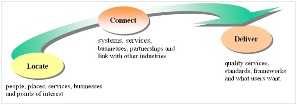
Figure 1. Locate, connect and deliver spatial information.
With this in mind and in order to better manage and utilise spatial
data assets, many countries around the world are developing SDI as a way
to facilitate data management and data sharing and utilise their spatial
data assets as this information is one of the most critical elements
underpinning decision making for many disciplines. The steps to develop
an SDI model vary, depending on a country’s background and needs.
However, it is important that countries develop and follow a roadmap for
SDI implementation.
SDI as an enabling platform is an integrated, multi-levelled
hierarchy of interconnected SDIs based on partnerships at corporate,
local, state/provincial, national, multi-national (regional) and global
levels. This enables users to save resources, time and effort when
trying to acquire new datasets by avoiding duplication of expenses
associated with the generation and maintenance of data and their
integration with other datasets. However, SDI is an evolving concept and
can be viewed as an enabling platform linking data producers, providers
and value adders to data users. With this in mind, many nations and
jurisdictions are investing in developing such platforms and
infrastructures that enable their stakeholders to work together in a
more mutual approach and to create distributed virtual systems that
support better decision-making. At the same time, these nations and
jurisdictions need a system to assess and monitor the development and
performance of the platform.
The development of an SDI as an enabling platform for a country will
enhance the capability of government, the private sector and the general
community in engaging in systems based, integrated and holistic decision
making about the future of that jurisdiction and this could help the
country capacity to respond to MDGs and meeting sustainable development
objectives. Applications, tools, and different sorts of information
required to achieve these objectives would be available through the
platform to build a view of, query and allow decisions to be based on,
both the built and natural environments which further could help in
responding to MDGs. Having said that, however, there is a need to move
beyond a simple understanding of SDI, and to create a common rail gauge
to support initiatives aimed at solving cross-jurisdictional and
national issues. This SDI will be the main gateway through which to
discover, access and communicate spatially enabled data and information
about the country and regions. Such an entity can be enhanced so that it
is possible to share in addition to data, business goals, strategies,
processes, operations and value-added products.
SDIs aim to facilitate and coordinate the sharing of spatial data
between stakeholders, based on a dynamic and multi-hierarchical concept
that encompasses the policies, organizational remits, data,
technologies, standards, delivery mechanisms and financial and human
resources necessary to ensure that those working at the appropriate
(global, regional, national, local) scale are not impeded in meeting
their objectives (GSDI, 1997). This in turn supports decision making at
different scales for multiple purposes, and enables users to save both
time and money in accessing and acquiring new datasets by avoiding
duplication of expenses and effort associated with the generation and
maintenance of spatial data (Rajabifard et al. 2006a).
| However, effective use of spatial
information requires the optimization of SDIs to support spatial
information system design and applications, and subsequent
business uses. The need to find optimal SDI models requires
ongoing research that reflects current social, cultural and
business systems, as the measured benefits of building SDIs have
not been as forthcoming as projected. To achieve this, the
concept of an SDI is moving to a new business model, in which
the SDI promotes partnerships of spatial information
organizations (public/private), allowing access to a wider scope
of data and services, of greater size and complexity than they
could individually provide. SDI as an enabling platform can be
viewed as an infrastructure linking people to data (Rajabifard
et al., 2006b) through linking data users and providers on the
basis of the common goal of data sharing (Figure 2). |
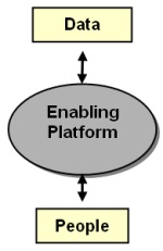
Figure2. SDI connecting people to data |
In this environment all types of organizations participating
(including governments, industries, and academic) can gain access to a
wider share of the information market. This is a vision to facilitate
the integration of existing government spatial data initiatives for
access and delivery of data/information to a wider society and also at a
multi-national level collaboration. This integration would be based on
common standards and business understanding and combines distributed
functions provided by participating organizations to deliver services
which structured and managed in such a way that to be seen by third
parties as a single enterprise.
The creation of an enabling platform would lower barriers to access
and use of spatial data, to both government and the wider community
within any jurisdiction, and particularly to the spatial information
industry. If barriers are minimised, then entities would be able to
pursue their core business objectives with greater efficiency and
effectiveness. In particular, industry would be able to reduce their
costs, which would encourage investment in capacity for generating and
delivering a wider range of spatial information products and services to
a wider market. Having said that, in order to develop a successful and
functioning platform requires a set of concepts and principles to enable
the design of an integration platform that facilitates interoperability
and inter-working of functional entities within a heterogeneous
environment. Further, these concepts and principles can be used as
indicators to assess the performance of SDIs.
3. SPATIALLY ENABLED SOCIETY
Spatially Enabled Society is a scenario for the future as we are in
an increasingly complex and rapidly changing world. Societies can be
regarded as spatially enabled ‘where location and spatial information
are regarded as common goods made available to citizens and businesses
to encourage creativity and product development’ (Wallace et al. 2006).
| In this regard, the vast majority
of the public are users, either knowingly or unknowingly, of
spatial information. With these considerations in mind, the
challenges that must be overcome to make existing SDIs more
appropriate for spatially enabling government and society
(Masser et al. 2007). Based on this view, there are four
strategic challenges arising (Figure 3).
The first of these is the need for more inclusive models of
governance given that SDI formulation and implementation
involves a very large number of stakeholders from all levels of
government as well as the private sector and academia. The
second concerns the promotion of data sharing between different
kinds of organization. In some cases this may require new forms
of organization to carry out these tasks. The third challenge
relates to the establishment of enabling platforms to facilitate
access to spatial data and the delivery of data related
services. The fourth challenge arises from the changes that are
taking place in the nature of the users of spatial information
in recent years. |
Spatially Enabled
Society
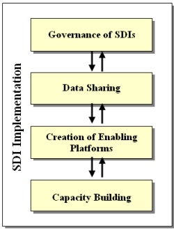
Figure 3. Strategic Challenges |
In place of the spatial professionals who have pioneered these
developments an increasing number of end users will need some training
in spatial thinking to make them more literate users. Consequently there
are a number of new capacity building tasks to be undertaken in order to
create a fully spatially enabled government.
Further, a spatial enabled government is one that plans to achieve
three broad goals:
- More effective and more transparent coordination, where voters
are able to access the spatial information they require to evaluate
the choices made by elected decision makers;
- The creation of economic wealth through the development of
products and services based on spatial information collected by all
levels of government; and
- The maintenance of environmental sustainability through the
regular and repeated monitoring of a wide range of spatial
indicators distributed throughout the country as a whole.
Realizing this vision of spatially enabled society is dependent on
the development of appropriate mechanisms to facilitate the delivery of
data and services. These mechanisms should embody the following
principles that are the foundation of the INSPIRE initiative (CEC 2004).
- Collect spatial data once. Maintain at most effective level;
- Seamlessly combine spatial data from different sources, “mix and
match”, visualise and share it among many users and applications;
- Collect spatial data at one level of government and share it
with Whole of Government;
- Make spatial data needed for good governance available without
restrictions on use;
- Identify what spatial data is available, its fitness for purpose
and conditions on its use, through effective sorting and data
mining.
- Organise government business processes around “place”
information by geocoding of places and features.
4. FUTURE DIRECTIONS
In order to facilitate the realization of spatially enabled society
and governments, there is a need for a service-oriented infrastructure
on which citizens and organizations can rely for the provision of
required services, going beyond what has been described as the first and
second generation of SDI development of a data discovery and retrieval
nature (Rajabifard et al. 2003). This includes a focus for spatial
information managers on the delivery of a virtual world which
facilitates decision making at a community level within a national
context. There is also the need to develop institutional practices to
make existing and future technology more effective. Research has found
that very few jurisdictions have developed a framework for establishing
a spatial infrastructure that addresses comprehensively operational,
organizational and legal issues. It is these processes that will enable
the infrastructure to be readily useable and available to all
stakeholders.
This translates into the future focus for spatial information
managers on the delivery of a virtual world which facilitates decision
making at a community level within a national context. This requires
integration of the natural and built environmental data sets and the
need for a spatial data infrastructure that facilitates this
integration. The technology exists to create this virtual world but this
is not enough in itself without the sustained input from both data
producers and users.
The benefits of a virtual world will include the representation of
feature-based structures of the world as well as the administration and
institutional aspects of such features, enabling both technical and
institutional (eg. policies) aspects to be incorporated into
decision-making. It is this aspect of research that is often identified
as more challenging than complex technical issues. The vision of a
virtual world however is overly simplistic and presents many challenges,
with one of the major challenges being the creation of an SDI to support
the vision. Whilst most SDI authorities will agree that SDIs should be
user driven, there is little discussion on the spatial information
vision for each country or what sort of ICT enabled society we wish to
be. However unless an agreement on a spatial information vision for each
country (or jurisdiction) is made, it is almost impossible to create an
appropriate SDI vision. Therefore the first challenge is to clearly
describe and articulate the type of society an SDI should support. Some
other challenging questions for future SDI development are posed by the
need for a high level of multilevel stakeholder participation in SDI
implementation.
Further, the development of SDI initiatives driven more by
sub-national governments differ from the top-down approach that is
implied by the development of national led SDIs, implicit in much of the
current SDI literature. This new bottom-up sub-national view is
important as it highlights the importance of diversity and heterogeneity
given the different aspirations of various stakeholders. Consequently,
the challenge to those involved in SDI development is to find ways of
ensuring some measure of standardization and uniformity while
recognising the diversity and heterogeneity of various stakeholders. The
use of open standards and an interoperable enabling platform will allow
functions and services that meet business needs to be brought together
at a sub-national and application level, reducing duplication of effort
and furthering the development of a spatially enabled society.
Having said that, the ability to implement spatial enablement,
requires a range of activities and processes to be created across all
jurisdictional levels (Rajabifard 2007). These include:
- an enabling platform comprising institutional, collaborative
framework, governance, legal and technical tools for data sharing as
part of ICT, e-government and information sharing strategies;
- building on NSDI and related initiatives;
- using geocodes and “place” related information, such as national
geocoded street address files;
- facilitating the use of legal land parcels and legal property
objects to better manage all rights, restrictions and
responsibilities relating to land;
- developing more holistic data models to integrate separate land
administration data silos where they exist;
- maintaining complete and optimally continually updated national
cadastral maps of legal parcels, properties and legal objects, as
part of the NSDI;
- often re-engineering the institutions of government;
- increasingly legal frameworks to facilitate integration and
management;
- activities on spatial data standards, interoperability and
integratability;
- development of authoritative registers of key spatial
information;
- research and development;
- growth in capacity at societal, institutional and individual
levels.
5. GSDI ASSOCIATION AND VISION OF SPATIALLY ENABLED SOCIETY
The GSDI Association is a non-profit, inclusive, global organization
made up of members from different countries both from emerging and
developed nations, major industry and government organizations, and
individuals. The organization promotes international cooperation and
collaboration in creating local, national and international SDI to
assist nations to address social, economic, and environmental issues.
The Association promotes the Global SDI to facilitate ready, world wide
access to geographic and spatial information to support decision making
at all scales for multiple purposes.
The Association plays a critical role in helping to address societal
problems through the use of spatial capacity. GSDI Association has come
along way since the GSDI initiative began in 1996 and the Association
came into existence in 2002. However, the scope of the Association has
broadened considerably in this relatively short time. This reflects the
expanding uses to which spatial capacity is now able to be deployed, the
increasing diversity of organizations and skills now using this
capacity, and the corresponding expansion in demands of Association
members.
The essence of what the Association does is help to create an
enabling environment that enhances outcomes in societies, economies and
the global environment. The betterment of societies through spatial
enablement is one of the goals of this association. Spatial enablement
will assist both developed and developing countries to pursue
sustainable development objectives and MDGs and it will ensure better
productivity and efficiency. Therefore, GSDI Association considered
“Realizing Spatially Enabled Societies” as a theme for the Association
in the next period and the GSDI-12 world conference in Singapore in
October 2010.
6. CONCLUSIONS
Responding to millennium development goals and meeting sustainable
development objectives we need to develop can be achieved through the
development of products and services based on spatial information
collected by all levels of governments and these objectives can be
facilitated through the development of a spatially enabled government
and society. The development of a spatially enabled government and
society is ongoing and multi-disciplinary; achieving it will draw on a
wide range of experiences and disciplines from surveying and mapping,
land administration, GIS, information and communications technology,
computer science, legal and public administration and many more. This
paper has addressed four strategic challenges that need to be considered
when implementing SDIs to spatially enable society.
The first of these indicates the need for new and more inclusive
models of governance to enable the very large number of stakeholders
from all levels of government as well as the private sector and academia
to participate in the management of the processes of SDI implementation.
The second challenge considered the strategic questions associated with
data sharing between different kinds of organization. The third
challenge relates to the establishment of enabling platforms to
facilitate access to spatial data and the delivery of data related
services. It can be viewed as an infrastructure linking people to data
through linking data users and providers on the basis of the common goal
of data sharing. Further, this infrastructure would be a vehicle from
which both textual and spatial data are utilized to form a range of
supported functions for those within the industry as well as non-spatial
and non-technical user groups. The fourth challenge related to the
capacity building issue which tasks to be undertaken in order to create
a fully spatially enabled society. Further, the ability to implement
spatial enablement, requires a range of activities and processes to be
created across all jurisdictional levels.
REFERENCES
- Commission of the European Communities, (CEC), (2004), Proposal
for a Directive of the European Parliament and the Council
establishing an infrastructure for spatial information in the
Community (INSPIRE), COM (2004) 516 final, Brussels: Commission of
the European Communities.
- GSDI, (1997), Global Spatial Data Infrastructure conference
findings and resolutions, Chapel Hill, North Carolina (http://www.gsdi.org/docs1997/97_gsdi97r.html)
- Masser, I. (2005), GIS worlds: creating spatial data
infrastructures, Redlands CA ESRI Press.
- Masser, I., Rajabifard, A., and Williamson, I.P. (2007),
‘Spatially Enabling Governments through SDI implementation’,
International Journal of GIS, Vol. 21, July, 1-16.
- Rajabifard, A. (Eds), 2007, ‘Towards a Spatially Enabled
Society’ ISBN 978-0-7325-1620-8, The University of Melbourne. 400
pp.
- Rajabifard, A., Binns, A., Masser, I., and Williamson, I.P.
(2006a), ‘The Role of Sub-national Government and the Private Sector
in Future SDIs’, Vol 20, No 7, International Journal of GIS,
727-741.
- Rajabifard, A., Binns, A. and Williamson, I. (2006b), Virtual
Australia – an enabling platform to improve opportunities in the
spatial information industry, Journal of Spatial Science Special
Edition, Vol. 51, No. 1, June 2006.
- Rajabifard, A, Feeney, M.E.F., Williamson, I.P., and Masser, I.,
(2003), ‘National SDI Initiatives ’, Chapter6, Development of
Spatial Data Infrastructures: from Concept to Reality, ISBN
0-415-30265-X, Taylor & Francis, U.K.
- Wallace, J., Rajabifard, A., and Williamson, I. (2006), Spatial
information opportunities for Government, Journal of Spatial
Science, Vol. 51, No. 1, June 2006.
BIOGRAPHICAL NOTES
Dr. Abbas Rajabifard is an Associate Professor and Director of
the Centre for SDIs and Land Administration at the Department of
Geomatics, the University of Melbourne. He is President of the GSDI
Association, was Vice Chair of Working Group 3 of the United Nations
supported Permanent Committee on GIS Infrastructure for Asia and the
Pacific (PCGIAP), and is a member of ICA-Spatial Data Standard
Commission, and a member of Victorian Spatial Council.
CONTACTS
Assoc/Prof Abbas Rajabifard
GSDI President
Centre for SDIs and Land Administration
Department of Geomatics
The University of Melbourne
Victoria 3010
AUSTRALIA
Tel. + 61 3 8344 0234
Fax + 61 3 9347 2916
Email: abbas.r@unimelb.edu.au
Web site:
http://www.csdila.unimelb.edu.au/people/rteam/abbas.html
 |