Article of the Month -
May 2005
|
After the Tsunami – How the Surveying Profession Can
Participate in the Reconstruction
Daniel ROBERGE, Canada
 This article in .pdf-format in English

This article in .pdf-format in French
 . .
1) This paper has
been prepared and presented at the FIG Working Week / GSDI-8 Conference in
Cairo, Egypt, April 16-21, 2005. It is also a contribution to the discussion
how professional associations can contribute to risk and disaster
management. At its meeting in Cairo the Joint Board of Geospatial
Information Societies decided to establish an ad hoc working party on risk
and disaster management, chaired by Prof. Bengt Rystedt from ICA.
1. CONTEXT
Like most of us, I was horrified by the death toll left by the tsunami,
saddened by the thought of all the orphans and broken up families and amazed
by the magnitude of the disaster. Then, I asked to myself, what can I do? I
wondered what I could personally do to help; how my knowledge and experience
could benefit the victims at a tangible level?
In a near future, it will be necessary to start the resettlement of these
devastated communities. The scope of the task ahead is staggering? In
certain areas, everything was completely destroyed, wiped out by the
devastating wave. They have to rebuild everything … from scratch. It is
worst than after a war.
How can you resettle communities and land owners without any fences,
buildings or occupation marks? What a challenge … even for a land surveyor!
2. THE IMPORTANCE OF LAND TENURE ISSUES
Many of us have been involved, in our respective countries, in a project
of reconstruction or resettlement after a natural disaster. Flood,
landslide, hurricane, avalanche, and, or rare occasions, tsunami, are some
of the situations in which land surveyors have to get involved. Our
contribution is neither spectacular nor glamorous. We are not under the
spotlight like rescue teams, policemen, doctors, etc. Nevertheless, our role
is no less important but merely, too often, unknown or misunderstood.
As land experts and guardians of land rights, we are what could be called
« peace keepers by anticipation». In fact, our intervention regarding land
rights and land tenure issues may avoid further land conflicts. We must
remember that every war between nations or conflict between two neighbours
finds its source in the right to a piece of land. This is why the land
surveyor’s role is so important in a project of resettlement after a natural
disaster. And it is that much more critical after the Asian Tsunami because
the level of devastation is colossal.
In a best case scenario, some spatial data infrastructure and a geo-based
cadastre may exist. Hopefully it is the case in some areas like Phuket. But
elsewhere? It will almost be like starting over. And that is why it will be
crucial to resettle people correctly, to respect everyone’s land rights,
both legal and customary rights.
3. STATE OF THE SITUATION
We, as land surveyors, are aware of the role that we can play after a
natural disaster like the one that affected countries surrounding the Indian
Ocean last December. But how can we be sure that our role will be taken into
consideration within the reconstruction plans if we are not there on the
ground?
As far as we know, a non-governmental organization (NGO) formed to
intervene after a natural disaster to manage the land tenure issues, a kind
of Land Surveyor Without Frontiers does not exist.
So, who takes care of land tenure issues? How are they managed?
With its Land Tenure Service, the Food and Agriculture Organization (FAO)
promotes land tenure issues. Without having a specific document about
resettlement, FAO published some very good points enhancing the importance
of these concerns. Here’s one of their statement:
«Failure to consider land tenure implications at the beginning of an
intervention is likely to result in unanticipated outcomes and may lead to
it not generating improvement. In some cases, it may even worsen the
situation, for example by inadvertently dispossessing people of their
rights to land. Situations of this kind have arisen, for example, when
projects have resettled people on land that was incorrectly identified as
vacant» .2)
2) FAO.
Land Tenure and rural development No 3. 2002. p. 3
In guides and handbooks regarding resettlement after a natural disaster,
we found two documents produced by the World Bank Group:
- The Economics of Involuntary Resettlement, published by the World Bank
3)
- Handbook for Preparing a Resettlement Action Plan.
4)
3) World
Bank. 1999. The Economics of Involuntary
Resettlement
4)
International Finance Corporation. 2002. Handbook for Preparing a
Resettlement Action Plan
Both of them mention the World Bank Directive OD 4.30 which is about
Involuntary Resettlement. In this directive, Section 17 clearly addresses
land tenure issues:
«17. Land Tenure, Acquisition and Transfer
Resettlement plans should review the main land tenure and transfer
systems, including common property and non title-based usufruct systems
governed by locally recognized land allocation mechanisms. The objective
is to treat customary and formal rights as equally as possible in devising
compensation rules and procedures. The plan should address the issues
raised by the different tenure systems found in a project area, including
(a) the compensation eligibility of land-dependent populations; (b) the
valuation procedures applicable to different tenure types; and (c) the
grievance procedures available for disputes over land acquisition. Plans
should contain provisions for conducting land surveys and regularizing
land tenure in the earliest stages of project development.
Planning should also anticipate the approximate time needed to acquire and
transfer land.»
UN-HABITAT has a central position in the UN’s system in terms of
sustainable human settlement as we can see in the following diagram:
Main Relief Bodies / Agencies responding
to a human crisis
and disaster and linkages with human settlements sector
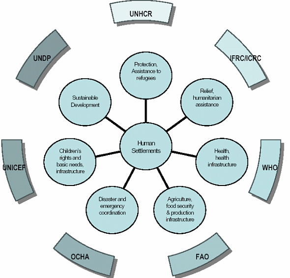
UN-HABITAT Disaster Management Programme
Concept document. 2003. p. 5
This UN agency produced two guides regarding post disaster situations:
- Guidelines for the Evaluation of Post Disaster Programmes – A Resource
Guide 5);
- Guidelines for Operational Programme formulation in post disaster
situations 6).
5) United Nations
Center for Human Settlement (HABITAT). Guidelines
for the Evaluation of Post Disaster Programmes – A Resource Guide. 2001
6)
United Nations Center for Human Settlement (HABITAT). Guidelines for
Operational Programme formulation in post disaster situations – A Resource
Guide. 2001
Surprisingly, in these documents, there is not a single word about land
tenure issues.
Fortunately, UN-HABITAT launched, in July 2003, the Disaster Management
Programme (DMP) 7) . The mission of
this programme is to support national governments, local authorities and
civil society into strengthening their capacity to manage human-made and
natural disasters affecting human settlements. The DMP operates under the
Disaster, Post-Conflict and Safety Section, Urban Development Branch of
UN-HABITAT. It was created to marshal the resources of UN-HABITAT and other
agencies to provide local government, civil society and private sector with
practical strategies for mitigating and recovering from conflicts and
natural disasters in the context of human settlements.
7) United Nations
Human Settlements Programme. Disaster Management
Programme – Concept Document. 2003.
In the DMP Concept Document, we can read some concerns about land tenure.
Namely, under the Immediate Objective 3: To assure sound human
settlements for Internally Displaced Persons and refugees, there is
output concerning security of land and property tenure which has the
following activities:
- Development of mechanisms for dispute resolution and conflict
management in regard to land and property during the emergency and
reconstruction phase;
- Protection of property rights of refugees and displaced populations,
with particular emphasis on access of women to land and security of
tenure;
- Development of sustainable legal systems to regularize and register
land property rights and manage land and property issues in a transparent
way;
- Strengthening legal frameworks in regard to land and property.
Further in the document we can read that DMP also provides support in
land and property management, and facilitates deployment of a team of legal
and land management experts to undertake scoping and immediate measures
protecting the land and property rights of displaced persons, and developing
longer term solutions for land and property dispute resolution.
After the Asian tsunami, or more generally after any natural disaster,
many UN agencies are mobilized to help affected countries. DMP/UN-HABITAT
has a central position in the UN system in terms of sustainable human
settlement and seems to play a key role in post disaster situation.
4. HOW CAN WE PARTICIPATE IN THE RECONSTRUCTION?
In general, UN agencies are not very loquacious about land tenure issues
and the different aspects regarding land rights that could be taken into
account after a natural disaster. To our knowledge, since December 26th, in
all the news, press releases and documents issued by the United Nations and
its agencies, none were about land tenure issues.
The international land surveyors’ community has to promote the importance
of land tenure aspects after a natural disaster, specifically in conjunction
with UN agencies. We have to be involved early in the reconstruction project
to ensure that land tenure and boundary aspects are thought out in the
reconstruction/resettlement plan.
One month after the Indian Ocean Tsunami, Mr Jan Egeland, the
United Nations Under-Secretary-General for Humanitarian Affairs and
Emergency Relief Coordinator said, «I think we are starting now the new
phase, as of today, which is the recovery and rehabilitation phase»
8).
8) United Nations.
One month into tsunami relief effort, UN faces even
bigger rehabilitation task. UN Press Release 26 January 2005.
«We did save a lot of lives, but we have not rebuilt their livelihoods
nor given them a standard of living that is anywhere near what they should
have», he declared. «That is a big, big task ahead and that will be even
bigger than the lifesaving emergency phase».
The international land surveyors’ community has to be part of this
reconstruction phase.
What would be the best way for land surveyors to contribute efficiently to
the reconstruction effort after a natural disaster? There are some options:
- Create a new Land Surveyors’ NGO (a kind of Land Surveyors Without
Frontiers organization) aiming at participating in the reconstruction
after a disaster;
- Intervene with our respective national governments;
- Develop an intervention collaboration strategy between FIG and UN
agencies.
Creating a new NGO may not be a good option as there are too many of them
and are difficult to coordinate.
The second possibility is not easy to manage and presents a coordination
problem. In the days following the tsunami, we have seen a fantastic
worldwide movement of solidarity towards ravaged countries. Most governments
promised help and money and many of them are willing to send experts to
collaborate in the reconstruction. But this help, coming from every
direction, is very hard to coordinate. It may, in many cases, worsen the
situation.
The option of a collaboration/intervention strategy with UN agencies
seems most promising. In my opinion, this strategy has to be put to work and
could be developed either by a special working group or through a seminar on
the subject, for example. Most importantly, should be developed along with
UN agencies to ensure that it corresponds to their needs. FIG should be
involved in the Disaster Management Programme to cooperate with UN-HABITAT
in the protection of land rights of displaced people and other land tenure
issues in a post disaster situation
FIG may choose other ways to build this strategy and opt for a different
level of intervention but this international organization has to act now,
not only regarding the present situation in South East Asia, but in the
possibility of future catastrophes.
ABOUT THE AUTHOR
Daniel Roberge graduated from Laval University’s Faculty of
Forestry and Geomatics, and is a member of the Québec’s Professional Order
of Land Surveyors. He is carrying on Graduate Studies in International
Administration at École Nationale d’Administration publique.
Manager and Senior Officer at the Ministère des Ressources naturelles, de
la Faune et des Parcs (Department of Natural Resources, Wildlife and Parks)
since 1993, Mr. Roberge has been involved in the design, development and
implementation of two of the most extensive land reforms ever undertaken in
North America: the Reform of the Québec Cadastre, which covers all
privately-owned land in Québec, and the Modernization of the system to
record rights on public land.
He is actually the Director of the Office of the Surveyor General of
Québec and the Vice-President of the Champlain Branch of the Canadian
Institute of Geomatics.
CONTACTS
Daniel Roberge, Director
Office of the Surveyor General of Québec
Ministère des Ressouces naturelles, de la Faune et des Parcs
Department of Natural Resources, Wildlife and Parks
5 700, 4e Avenue Ouest, local F 310
Charlesbourg (Québec) G1H 6R1
CANADA
Tel. + 1 418 627 6263 ext. 2646
Fax + 1 418 643 6512
Email:
daniel.roberge@mrnfp.gouv.qc.ca
Web site:
- English :
http://www.mrnfp.gouv.qc.ca/english/land/index.jsp
- Français :
http://www.mrnfp.gouv.qc.ca/foncier/index.jsp
 |


