Article of the Month -
February 2007
|
Provision of Emergency Communication Messages through Satellite Based
Augmentation Systems for GNSS: The ESA ALIVE Concept
Javier VENTURA–TRAVESET, Ankit Raj MATHUR and Felix TORAN, European
Space Agency (ESA), EGNOS Project, Toulouse, France and Hans-Peter PLAG
University of Nevada, Nevada, USA
 This article in
.pdf-format.
This article in
.pdf-format.
SUMMARY
The European Tripartite Group, (ESA – EC – EUROCONTROL) has implemented,
via the EGNOS project, the European contribution to the first generation of
Global Navigation Satellite System (GNSS-1). The European Space Agency (ESA)
has been in charge of the system design, development and qualification of an
Advanced Operational Capability (AOC) of the EGNOS system (also known as
EGNOS V1).
In summer 2005, EGNOS has reached two major program milestones through
the formal technical qualification process (known as ORR, Operational
Readiness Review) and the start of its initial operations. These two events
mark a successful completion of more than 8 years of intensive work by ESA
and European industry.
In parallel to the start of EGNOS operations, EGNOS is planning a
modernization plan to cope with GPS modernization, service extension,
standard evolutions and the anticipation of some future Galileo missions. In
this context, the availability of free bandwidth enables systems like EGNOS
to broadcast additional communication messages. These messages could be, the
broadcast of
- Warnings or instructions on the occurrence of natural disasters,
calamities, dangers for the safety of life within areas with poor
telecommunication infrastructure
- Search and Rescue Return Link Messages
- Warnings or instructions on limitations in the use of SBAS for
specific applications (e.g. aviation)
- Other uses.
We refer to these, in general, as the Communication Function of EGNOS. Of
these, this paper will focus mainly on the first two. The ESA ALIVE concept,
(Alert interface via EGNOS) is concerned with the provision of early warning
messages to citizens or governmental/local authorities in the event of a
major event or disaster. The authors consider the ESA ALIVE a meaningful and
viable concept, which may be implemented in a reasonable short time frame,
contributing to save lives in the event of disasters.
1. INTRODUCTION
Disaster prevention and mitigation is a subject to which currently
intensive attention is devoted. One of the main goals is to identify ways to
inform people at risk, for instance, through natural events such as
earthquakes, tsunamis, hurricanes, storm surges, extreme precipitation and
flooding, or volcanic eruptions, so that specific actions can be taken to
mitigate the impact of the disaster and ultimately, to save lives. Moreover,
the same information channels would be valuable tools to support rescue and
aid operations in the aftermath of disasters thus reducing the total loss of
human lives. This discussion is motivated by the obvious principle that
disaster prevention, mitigation and preparedness are better than mere
disaster response.
The ALIVE concept is concerned with the provision of early warning
messages to citizens or governmental/local authorities in case of a major
event or disaster.
The United Nations International Strategy for Disaster Reduction (UNISDR)
defines the term ‘early warning’ as follows [7]:
Early warning. The provision of timely and effective information, through
identified institutions, that allows individuals exposed to a hazard to take
action to avoid or reduce their risk and prepare for effective response.
Early warning systems include a chain of concerns, namely: understanding and
mapping the hazard; monitoring and forecasting impending events; processing
and disseminating understandable warnings to political authorities and the
population, and undertaking appropriate and timely actions in response to
the warnings.
Those most affected by disasters are often the poor and the socially
disadvantaged in developing countries as they are the least equipped to cope
with the situation. In large regions of the Earth, loss of life and capital
caused by disasters is increased by the lack of sufficient communication
infrastructure for warning, preparation and rescue. For instance, in African
countries and the Indian Ocean, where the lack of communication is a severe
limitation for efficient warning systems, additional communication paired
with a positioning service could be of great help.
2. DISASTER ALERTING MISSION
The term “disaster” denotes intense perturbation of people, goods,
services and environment, due to natural causes or generated by human being,
which exceed the reaction capacity of the affected community. Disasters can
be classified as:
- Natural disasters;
- Biological disasters;
- Technological disasters.
Disasters due to natural environmental forces can be classified as
follows:
- Disasters generated by dynamic processes in the Earth, including, for
instance; earthquakes, tsunamis or volcanic eruptions.
- Disasters generated by dynamic processes on the Earth’s surface,
including, for instance, land slides, rock avalanches, subsidence and
collapses.
- Disasters generated by meteorological or hydrological phenomena,
including, for instance, storm surges, inundation, extreme frost and
snowfall, storms, hailstorms, tornadoes, hurricanes, and wild fires.
Disasters of Biological nature also exist such as plagues or epidemics.
Finally, disasters of Technological nature encompass fire, explosions,
chemical substance spills, environmental contamination, wars, subversion,
and terrorism.
Obviously, the ALIVE mission will not necessarily focus on all types of
calamities listed above. A detailed mission assessment will be necessary as
a first step, identifying (at least):
- The available observation and sensing elements for each kind of
disaster, principally focusing on existing professional world-wide
networks.
- The kind of information that, derived from observation and information
systems, can be timely provided to end users to avoid personal damage and
save lives.
- The reaction time requirements.
- The added value of the position information.
- The associated information mission requirements (necessary bandwidth;
time to send; acknowledgement mechanisms; format; etc.).
- The potential recipients of the messages.
- Other available communication information means.
In general terms, the ALIVE system shall be able to:
- Sense primary variables relevant to inform (general people and
governmental/local authorities) on the kind and severity of a risk for a
disaster prior to the event, the precise location area of concern, as well
as to provide information for their mitigation in real-time;
- Provide complementary information that can help saving human lives,
such as the necessary action recommended to be taken;
- Broadcast this information through SBAS systems, via Geostationary
satellites, with a global coverage. In the case of EGNOS, this information
can also be broadcast through other means thanks to the EDAS (EGNOS Data
Access System) dissemination system.
3. THE EGNOS COMMUNICATION FUNCTION CONCEPT
3.1 Available EGNOS Bandwidth
In this section we briefly provide some information on the current
estimated available BW for additional EGNOS messages. This analysis is based
on the RTCA DO229C MOPS standards [6], which define the minimum update rate
that needs to be respected by EGNOS to comply with the safety of life
requirements.
Table 1 lists all current EGNOS broadcast messages and the minimum
necessary BW to comply with the International Standards. In this table, we
have assumed that MT0 (which is today sent every 6 seconds) is removed (as
it will be the case when transmitting Safety of Life messages early in 2007)
or combined with MT2 –MT0/2 (as planned to be implemented early 2006).
This analysis reveals that assuming GPS safety of life transmission the
BW available for additional messages will be of the order of 35% of the
total BW, i.e. equivalent to 75 bps. Since the transmission of EGNOS
messages is made in block messages of 250 bits, this opens up for the
transmission of about 1 message, of 250 bits per second, each 3–4 seconds.
Part of this extra BW could well be used to provide the EGNOS communication
messages like the information on disaster management through the ALIVE
interface.
In a dedicated study of the Search & Rescue return link possible
emergency services, a preliminary mission analysis based on Galileo revealed
that the bandwidth required to fulfill the mission requirements was 3.33%
(7bps) i.e. an EGNOS message is sent every 30 seconds (thus only consuming
about 1/10 of the total available extra BW). The ALIVE mission, being a
service of similar nature, is believed (though this needs to be confirmed by
the relevant disaster management experts) to require a bandwidth in the same
order of magnitude. Therefore, the ALIVE mission is considered to be fully
compatible with EGNOS existing margins. Moreover, the excess bandwidth can
be used for other EGNOS message broadcasting services, such as for EGNOS
extensions, or other communications functions or specific information to
aviation users on interferences (RFI) or similar.
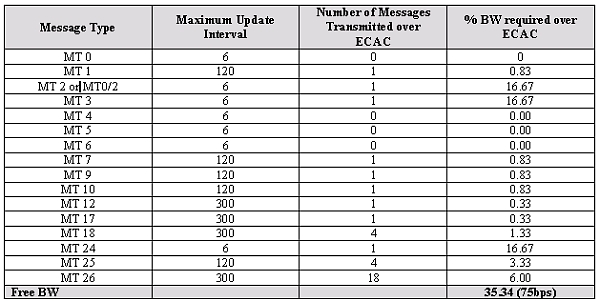
Table 1: EGNOS Message BW Utilization, with the MOPS specified update
rates with MT0/2 (or no MT0)
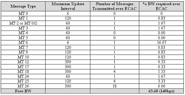
Table 2: EGNOS Message Bandwidth Utilization, with the update
intervals of fast corrections of 60 seconds
It is also worth to note that the available EGNOS BW may still be higher,
if the fact that the GPS Selective Availability (SA) has been removed in May
2000 is taken into account. Indeed, actual DO229C standards do allow the
relaxation of the update of the fast clock corrections from the 6 seconds to
be used in the case of SA activated (which is the current adopted baseline
in EGNOS) to up to 60 seconds when SA is off (which is the current
situation). Table 2 shows the equivalent available extra BW for EGNOS for
the case of SA off, which reaches a value of 63% (equivalent to 140 bps).
Thus, approximately one extra EGNOS message of 250 bps could be sent every 2
seconds for extra services, such as SAR return link and ALIVE. This is
believed to be a very comfortable BW for these kinds of services.
3.2 Architectural Concept and Preliminary Identification of
Operational Interfaces
The broadcast of these communication messages is based on the more
general concept of using the available EGNOS BW to broadcast spatially
related information from an originator to EGNOS users through dedicated SBAS
messages. Fig. 1 indicates the architectural implementation of such
communication function embedded within the EGNOS system.
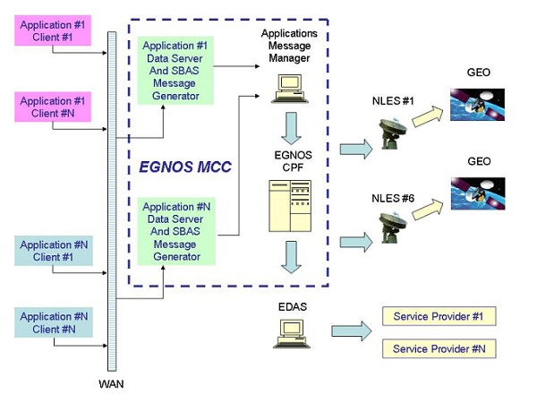
Fig 1: Broadcast of information through EGNOS
Independently from the application considered, the information to
transfer to EGNOS users is made available to the EGNOS computing platform
(CPF) through links and pre-processing stages. This information is then
broadcast as an SBAS message.
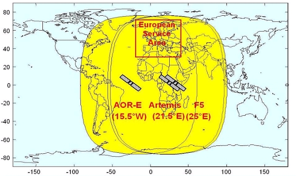
Fig 2: EGNOS Geostationary Satellites coverage
Users having the possibility to process these specific messages can then
extract the enclosed information and use it in the way they need. The added
value of this process is the opportunity to provide reliable information to
users equipped with an EGNOS terminal within the entire EGNOS geostationary
coverage as indicated in Fig. 2.
Safety critical information (event, recommended action) is typically
associated to spatial information (location). This will be of particular
importance for the functions of SAR and ALIVE.
3.4 ALIVE Architectural Concept
National and international organisations in charge of disaster management
or for the provision of civil protection services make use of
infrastructures for monitoring, communication and control. Here we denote
such infrastructures as Disaster Management Centres. The architectural
implementation of the ALIVE concept on the basis of the EGNOS system is
illustrated in Fig. 3.
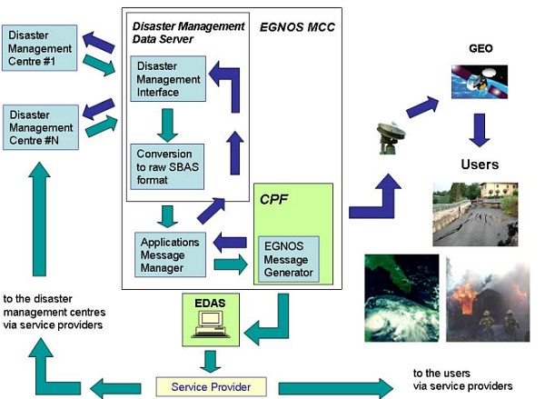
Fig 3: Architectural Implementation of ALIVE function
Disaster Management Centres have the task to collect and generate
relevant information (e.g.: event, location, status, action) required to
fulfill all the missions for which they have been designed. The information
generated by Disaster Management Centres is sent to a dedicated Disaster
Management Data Server (Specific Application Data Server) within the EGNOS
MCC, which converts this information into raw SBAS format and forwards it to
the Applications Message Manager. Disaster Management Centres receive
through the Disaster Management Data Server the acknowledgement that the
information has been sent with the typical EGNOS guarantee of service.
The Applications Message Manager has the following tasks:
- To receive the raw SBAS messages from all Applications Data Servers;
- To put the raw SBAS messages in a preliminary sequence according the
mission requirements of each application;
- To send the SBAS messages to the CPF;
- To receive the acknowledgement from the CPF that the message has been
sent;
- To return the acknowledgement to the Disaster Management Data Server
that the message has been sent.
The EGNOS computing platform (CPF) rearranges the broadcast sequence of
the SBAS messages according to the input provided by the Applications
Message Manager. The analysis of the preliminary mission requirements of
ALIVE revealed that there is no problem to allocate additional SBAS messages
among the broadcast of EGNOS current messages.
Once the broadcast sequence is ready, the message (or messages)
containing the information generated by the Disaster Management Centres, is
included in the EGNOS up-link and down-link loop in the same way as other
messages. Any user (within the EGNOS satellites footprint) equipped with an
EGNOS receiver capable of processing these additional messages is made aware
of the problem, location, status and action. Again, the EGNOS link loop
guarantees the delivery of the information to enabled users.
4. SBAS AN IDEAL SOLUTION TO CONTRIBUTE TO DISASTER ALERT
The provision of messages through SBAS is considered by the authors as a
very adequate solution for disaster management and SAR return link missions.
The SBAS systems (EGNOS, for the case of Europe) have a number of inherent
characteristics, which make the SBAS solution very attractive in both these
cases. This is explained and justified in this Section from different
perspectives.
4.1 Global Coverage
There are currently three SBAS systems available, which will all provide
service from 2006 (since 2003 for the case of WAAS): In Europe the EGNOS
System developed by the European Space Agency in tri-partite with the
European Commission and Eurocontrol, in the United States of America, the
WAAS (Wide Are Augmentation System) developed by the Federal Aviation
Administration and in Japan the Multi-function Transport Satellite (MTSAT)
Augmentation System or MSAS. Other regions are also interested in providing
SBAS services although their plans are less advanced than those in Europe,
the US and Japan (e.g. India’s SBAS, GAGAN, GPS and GEO Augmented
Navigation).
The three existing systems (EGNOS, WAAS and MSAS) provide service with a
global worldwide coverage, thanks to their complementary SBAS GEO broadcast
area footprints. This is illustrated in Fig. 4, where the existing EGNOS,
WAAS and MSAS GEO Broadcast areas are just illustrated (note that SBAS L1
broadcast is done through a global GEO beam). The resulting coverage on the
Earth is therefore complete with the only exception of the poles.
Consequently, when working together, the SBAS systems are a viable way of
broadcasting disaster alert/mitigation, SAR Return Link or other similar
messages worldwide, for users using the same frequency and signal standards,
and therefore fully compatible receivers.
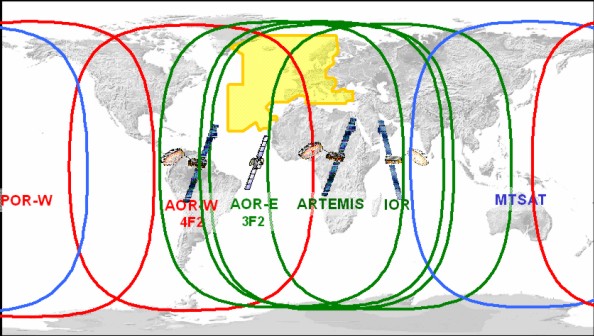
Fig 4: GEO broadcasting areas of the 3 existing operational SBAS
4.2 SBAS GPS Receivers Also Provide Positioning
Another interesting feature of the SBAS provision for alert management is
that in addition to the global coverage provided, the SBAS receiver (needed
to demodulate the SBAS disaster alert message) also provides, through their
embedded GPS receiver, precise position information. In this way, while a
message is sent globally, only those receivers concerned will be activated
(e.g. to take a given action or be prepared for rescue). Knowing then the
area of the possible disaster location or the beacon ID of the SAR Beacon,
the intended users could be warned. Other receivers, providing a position
outside the disaster area or with a different beacon ID, would instead be
transparent to the call and will not be activated. A possible conception
(for the sake of illustration) of the SBAS Alert prevention message is
illustrated in Fig 5.
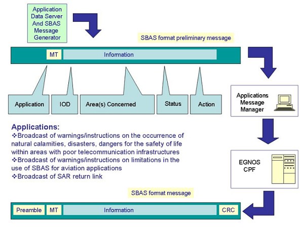
Fig 5: Illustration of a possible SBAS Communication message for
alert information
It is to be noted that nowadays, there are a large number of GPS/SBAS
receivers available on the market. Indeed, basically, because of the
similarity between GPS and the SBAS-GPS-like send signals, almost all
developed GPS receivers are also made SBAS compatible receivers. Therefore,
the reception worldwide of the SBAS alert message could be easily
implemented.
4.3 Communication link Available on all Circumstances
Either because of poor terrestrial communication infrastructure of the
disaster area (which unfortunately is often the case) or because the
disaster itself provokes a collapse of the land-based communications, it is
of high interest in those cases to have a guaranteed back-up communication
link. Satellite communication is the most natural back-up transmission means
in those cases. SBAS communication provides a potential satellite
communication link, available all the time on the disaster area,
irrespectively of the situation of the ground infrastructure. Furthermore,
it is to be noted that the most extended worldwide “satellite communication
receiver” is the GPS/SBAS receiver, in the sense of a device which is able
to receive specific communication data via satellite. No other satellite
communication mean is so widely extended.
4.4 Unique Standard for Common Receiver
It is also important to note that all the SBAS receivers follow the same
international standards, and therefore any SBAS receiver works anywhere in
the world in the SBAS coverage area. If a new SBAS message for disaster
prevention/mitigation or SAR return link is conceived, this may well be
standardised worldwide. This is considered an important feature allowing a
global worldwide standardised SBAS alert prevention system and a SBAS SAR
return link system.
4.5 SBAS Provide all Guarantees
The SBAS systems, having been conceived as safety of life systems with
integrity, include all the following built-in features which are crucial for
the considered alert information and SAR return link message, and which are
quite unique to SBAS:
- EGNOS has built-in mechanism that guarantees that a message has been
sent with the adequate content and on the appropriate time. This
information may also be provided back to the alarm or rescue centre
interfacing with SBAS.
- SBAS have built-in mechanism to make sure that a message went out in
good conditions with no errors.
- SBAS are safety of life systems operated 24 hours a day and 7 days a
week (i.e. no service interruptions, in case of failure quick recovery;
etc)
4.6 Can be Implemented in Very Short Term
For the case of EGNOS, the implementation of these interfaces is very
well suited to the existing EGNOS architecture. This is believed to be true
also for the other SBAS but is unknown to the authors. In the case of EGNOS,
the system upgrade to provide the anticipated facility could be done in a
short time frame, with low risk and with a simple approach, provided
adequate political and institutional support is given. It is believed that
this function could be readily available in EGNOS in a timeframe of 2 years
after program approval.
4.7 Under Institutional Control
The SBAS systems have all been developed and will all be operated under
institutional control. In the case of EGNOS, the system is currently owned
by the European Space Agency member states, and ownership is planned to be
transferred to the Galileo Supervisory Authority, a European Institutional
Organisation in charge of EGNOS operations and exploitation. WAAS and MSAS
are also under institutional control through their respective Governmental
Departments for transportation. For the mission intended, having
institutional control is considered a key feature since it guarantees
service provision, no service interruption, and system necessary future
upgrades.
4.8 Resilient to Spoofing and Malicious Denial of Service Attacks
A system such as this must implement measures to mitigate the affects of
any spoofing attacks and mitigate the affects of Denial of Service attacks.
Examples include "flooding" an alert network, so preventing legitimate
network traffic and so disrupting the entire broadcast service or preventing
a particular individual from accessing the service, such an attempt could
arise, for example, in the case that a terrorist group tried to amplify the
affects of an attack designed to cause mass casualties by preventing
dissemination of timely alerts. SBAS is not immune to such attacks but its
institutional control and operational concept makes it far more resilient to
such scenarios than other alternative forms of alert, typically those in
broadcast media.
4.9 Long system life time when combined with Galileo
Current SBAS systems have been conceived for a typical operation lifetime
of 15 years (i.e. for a time frame around 2020). In addition, there are
plans to further modernize SBAS systems and to adapt them to GPS and Galileo
modernization plans. EGNOS is currently integrated in the GALILEO overall
strategy, and therefore the complement to this SBAS function through Galileo
will also be smoothed and will ensure further long-term duration. This
long-term issue is considered a very important feature of the SBAS system,
which ensures continuity of the proposed ESA ALIVE system.
5. SUMMARY
Disaster prevention, mitigation and preparedness are better than disaster
response. The possibility to use Satellite Based Augmentation Systems (SBAS)
message broadcast capability as a means for disaster announcements has been
discussed in this paper. Specifically, the implementation of a dedicated
interface in EGNOS for disaster alert messages (ALIVE: Alert Interface Via
EGNOS for disaster prevention/mitigation) and for the Search & Rescue (SAR)
return link messages has been proposed. As explained through this paper, the
SBAS systems (such as EGNOS) have a number of inherent characteristics which
make the SBAS solution very attractive, including the possibility of global
coverage, provision of a combined warning and positioning system,
availability of a large number of worldwide common receiver with common
standards, SBAS built-in features that guarantee adequate message broadcast
(e.g. integrity of message, confirmation of transmission), and the fact that
SBAS are operated with safety of life guarantees and under institutional
governmental control.
This paper provides a preliminary analysis of the mission concept, the
interest of a possible SBAS solution for these communication functions, as
well as an outline of the potential architectural concept; and a possible
implementation path strategy.
There are many alternative communications channels through which disaster
alerts messages may be broadcast. These include traditional public address
systems, broadcast/media/internet and commercial services such as satellite
communications or SMS. SBAS cannot possibly provide a single universal
solution for the broadcast of alert messages since the environment and
circumstances of each disaster can vary considerably in terms of location,
urgency and recipients. This paper does however clearly demonstrate many
advantages over alternative channels and significant merit to the inclusion
of SBAS in this mix of systems.
The authors consider the ESA ALIVE proposal as meaningful and viable
concept, which may be implemented in a reasonable short time frame,
contributing to save lives in the event of disasters.
REFERENCES
[1] J.Ventura–Traveset et al, “The EGNOS ALIVE Interface (Alert Interface
via EGNOS) for disaster prevention and mitigation”, ESA Technical Note,
April 2005.
[2] J.Ventura–Traveset et al, “EGNOS Status, Performances & Planned
Evolutions (2006–2010)”, Proc. of the European Navigation Conference GNSS
2005, July 2005.
[3] A.R.Mathur, “EGNOS SAR preliminary mission analysis”, ESA internal
document, July 2005
[4] “Introduction to the COSPAS-SARSAT system”, C/S G.003, Issue 5, Rev.1,
Oct. 1999.
[5] “Cospas Sarsat 406MHz MEOSAR Implementation Plan”, C/S R.012, Issue 1,
Oct 2004
[6] Minimum Operational Performance Standards (MOPS) for Global Positioning
System/Wide Area Augmentation System Airborne Equipment, Nov. 2001.
[7] A study into the use of global Satellite Based Augmentation Systems
(SBAS) for Disaster Prevention and Mitigation: The ESA ALIVE concept. Helios
Report, ESA Contract 18982/2005/F/WE
CONTACTS
Javier Ventura-Traveset
E-mail:
Javier.Ventura-Traveset@esa.int
Ankit Raj Mathur
E-mail: Ankit.Raj.Mathur@esa.int
Felix Toran
E-mail: Felix.Toran@esa.int
European Space Agency (ESA)
EGNOS Project
Toulouse
FRANCE
Hans-Peter Plag
E-mail: hpplag@unr.edu
University of Nevada, Nevada, USA
 |


