Key words: Cadastre, Standards, 3D, 3D Cadastre,
Inventory
SUMMARY
In this paper, the background, set-up, and a preliminary
analysis of the survey conducted by the FIG joint commission 3 and 7
working group on 3D-Cadastre, 2010-2014 is presented. The purpose of the
survey is to make a world-wide inventory of the status of 3D-Cadastres
at this moment (November 2010) and the plans/expectations for the near
future (2014). Sharing this information improves cooperation and
exchange of experiences and supports future developments in different
countries and cadastral jurisdictions. The FIG working group will repeat
the survey in four years time to evaluate the actual progress. In the
questionnaire the concept of 3D-Cadastres with 3D parcels is intended in
the broadest possible sense. At the moment of writing, 36 completed
questionnaires have been received. Another detailed questionnaire survey
is being conducted among the eight cadastral jurisdictions of Australia,
and the results from these are also presented and compared to the
international situation. At the moment of writing, all completed
Australian questionnaires have been received.
1. INTRODUCTION
In the past decade various activities have been
conducted related to 3D-Cadastres. The start of the international
awareness of this topic was marked by the workshop on 3D-Cadastres
(sponsored by FIG commissions 3 and 7), organized by Delft University of
Technology in November 2001. This was followed by virtually a session at
every FIG working week and congress afterwards (stimulated by the
2002-2006 FIG working group on 3D-Cadastres). Within cadastral
organizations this was paralleled by on-going developments at Cadastral
organizations in many countries to provide better 3D-support. The
increasing complexity of infrastructures and densely built-up areas
requires a proper registration of the legal status (private and public),
which only can be provided to a limited extent by the existing 2D
cadastral registrations. Despite all research and progress in practice,
no country in the world has a true 3D-Cadastre, the functionality is
always limited in some manner; e.g. only registering of volumetric
parcels in the public registers, but not included in a 3D cadastral map,
or limited to a specific type of object with ad hoc semi-3D solutions;
e.g. for buildings or infrastructure.
At the FIG Congress in April 2010 in Sydney it was
decided to form again a working group on 3D-Cadastres in order to make
further progress with the subject; see Section 2 for more details of
this working group. The registration of the legal status in complex 3D
situations will be investigated under the header of 3D-Cadastres.
Starting point of the working group is the observation that increasingly
information is required on rights, use and value in complex spatial
and/or legal situations.
There are several 3D-Cadastre scoping options, which
need to be investigated in more detail by the working group, and the
result will define the scope of the future 3D-Cadastre in a specific
country:
-
What are the types of 3D cadastral objects that need
to be registered? Are these always related to (future) constructions
(buildings, pipelines, tunnels, etc.) as in Norway and Sweden or
could it be any part of the 3D space, both airspace or in the
subsurface as in Queensland, Australia?
-
In case of (subsurface) infrastructure objects, such
as long tunnels (for roads, metro, train), pipelines, cables: should
these be divided based on the surface parcels (as in Queensland,
Australia) or treated as one cadastral object (as in Sweden). In
case of subdivision, note that to all parts rights (and parties)
should be associated.
-
For the representation (and initial registration) of
a 3D cadastral object, is the legal space specified by its own
coordinates in a shared reference system (as is the practice for 2D
in most countries) or is it specified by referencing existing
topographic objects/boundaries (as in the 'British' style of a
cadastre).
Note that there can be a difference between the 3D
ownership space and the 3D restriction space; e.g. one can be owner up
to ±100 m around the earth surface, but only allowed to build from -10
to +40 m. Both result in 3D parcels, that is, 3D spatial units with RRRs
attached. The ownership spaces (parcels) should not overlap other
ownership parcels, but they are allowed to overlap other space; e.g.
restriction parcels.
Part of the activities of the working group is to make a
world-wide inventory of the status of 3D-Cadastres at this moment
(November 2010) and the plans/expectations for the near future (2014);
see Section 3. This will be done via a repeated questionnaire: one in
2010 (status 2010 and plans 2014) and one in 2014 (status 2014 and plans
2018). The repeated survey in four years time will be helpful to
evaluate the actual progress. Sharing this information improves
cooperation and exchange of experiences and supports future developments
in different countries and cadastral jurisdictions. A related survey has
been conducted among the eight cadastral jurisdictions of Australia (see
Section 4). The results and preliminary analysis of the international
FIG 3D-cadastres survey is presented in Section 5. Finally, Section 6
contains the conclusions and description of future work in the area of
3D-Cadastres.
2. FIG WORKING GROUP ON 3D-CADASTES
This section presents the FIG joint commission 3 and 7
working group on 3D-Cadastres (2010-2014). In subsection 2.1 the
objectives of the working group are formulated. The main research topics
of the working group are presented in subsection 2.2, while deliverables
and mode of operation are introduced in subsection 2.3. For more
information on the FIG working group on 3D-Cadastres, including the
overview of relevant 3D cadastre literature and the 35 completed
questionnaires, see the website of this working group
www.gdmc.nl/3DCadastres.
2.1 Objectives
The main objective of the working group is to establish
an operational framework for 3D-Cadastres. The operational aspect
addresses the following issues:
-
A common understanding of the terms and issues
involved. After the initial misunderstandings (due to lacking shared
concepts and terminology) in the early days, the concepts should now
be further refined and agreed on, based on the ISO 19152 Land
Administration Domain Model (LADM, which provides support for 3D
representations); see Figure 1.
-
A description of issues that have to be considered
(and to what level) before whatever form of 3D-Cadastres can be
implemented. One could think of a checklist for the implementation
of 3D-Cadastres. These will provide 'best practices' for the legal,
institutional and technical aspects. These findings will be
translated in basic guidelines for the implementation of
3D-Cadastres.
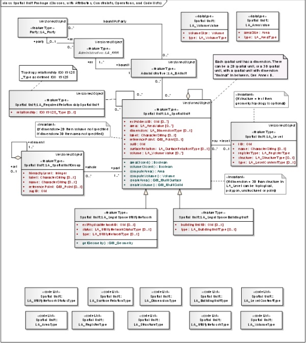
Figure 1. ISO 19152 with 3D spatial units and specializations
such as LA_LegalSpaceUtilityNetwork and LA_LegalSpaceBuildingUnit
By means of pursuing these issues we hope to have a
fruitful exchange of ideas. There exists not a unique 3D-Cadastre. In
all cases for the establishment of such a cadastre legal, institutional
and technical issues have to be addressed. The level of sophistication
of each 3D-Cadastre will in the end be based on the user needs, land
market requirements, legal framework, and technical possibilities.
Therefore, in line with ISO's LADM it is our objective to explore the
optimal trade-offs between 2D and 3D cadastral solutions (the full
replacement of a 2D-Cadastre by a 3D-Cadastre is not an issue, but we
need to address the issues that arise in the transition zones).
The working group will focus primarily on professionals
involved in geo-information and cadastral issues in 3D. This community
will also provide the contributors to the working group. Access to this
interest group is open to all. Once the results become more tangible the
FIG-community at large will be our public.
Within the working group the concept of 3D-Cadastres
with 3D parcels is intended in the broadest possible sense. 3D parcels
include land and water spaces, both above and below surface. However,
what exactly is (or could be) a 3D parcel is dependent on the legal and
organizational context in the specific country (state, province). For
example, in one country a 3D parcel related to an apartment unit is
associated with an ownership right, while in another country the
government may be owner of the whole apartment complex and the same
apartment unit is related to a use right. In both cases there are
explicit 3D parcels, but with different rights attached. A third country
may decide not to represent the apartment units with explicit 3D
geometries at all (and the 3D aspect is then 'just' conceptual). A more
formal definition: A 3D parcel is defined as the spatial unit against
which (one or more) unique and homogeneous rights (e.g. ownership right
or land use right), responsibilities or restrictions (RRRs) are
associated to the whole entity, as included in a Land Administration
system. Homogeneous means that the same combination of rights equally
apply within the whole 3D spatial unit. Unique means that this is the
largest spatial unit for which this is true. Making the unit any larger
would result in the combination of rights not being homogenous. Making
the unit smaller would result in at least 2 neighbour 3D parcels with
the same combinations of rights.
2.2 Research topics
The working group identified four main research topics:
models, Spatial Information Infrastructure (SII, sometimes also called
SDI), temporal aspects and usability. These four topics are elaborated
on below:
-
3D-Cadastres and models: It is important to realize
that for registration, for storage/validation and for dissemination
different models (all based on the shared ISO LADM semantics) may be
needed and different types of users are involved. The modelling
aspect includes the question of which spatial (esp. height) and
temporal information should be used and how different types of users
may interact (i.e. produce, archive, edit, analyze, and visualize,
edit) with 3D-Cadastre? The 'users' belong to various categories;
they range from professionals (which can be further subdivided in
notary, real estate brokers, banks, water boards, utility companies,
municipalities, cadastral employees, surveyors, etc.) to citizens
(with various capabilities of owners/users: from computer
illiterates to experienced web surfers/gamers).
-
3D-Cadastres and SII: The registration of legal
objects (cadastral parcels and associated rights) and their physical
counterparts (e.g. buildings or tunnels) result into two different,
but related data sets, which can be very well accessed together via
the Spatial Information Infrastructure (SII, sometimes also called
SDI). This is already true in 2D, but even more so in 3D. By also
showing some physical objects for reference purpose, the location
and size of the legal objects will be clearer.
-
3D-Cadastres and time: A 4D parcel is defined as the
spatio-temporal unit against which (one or more) unique and
homogeneous rights (e.g. ownership right or land use right),
responsibilities or restrictions are associated to the whole entity,
as included in a Land Administration system. Homogenous means that
the same combination of rights equally apply within the whole 4D
spatial temporal unit. Unique means that this is the largest
spatio-temporal unit for which this is true. Making the unit any
larger (in 3D space or time) would result in the combination of
rights not being homogenous. Making the unit smaller (in 3D space or
time) would result in at least 2 neighbour 4D parcels with the same
combinations of rights.
-
3D-Cadastres and usability: The graphic user
interface (GUI) is an essential aspect when realizing 3D-Cadastres
in practice. This includes investigation of interacting with true 3D
cadastral data (specific user interfaces: 3D spatial and perhaps
temporal aspects via animations or snapshot sliders). The existing
quality of successful and popular user interfaces (such as Google
Earth; see Figure 2) will be the starting point with specific
attention for working with the main 3D legal object types (related
to underground infrastructure and building/apartment complexes). A
true 3D cadastral system with functions should be implemented and
applied to demonstrate the possibilities in practice based on 3D
visualization. How to distribute the 3D cadastral information (3D
parcels and associated rights) to the citizens? How to represent and
demonstrate the 3D geographic aspect, on paper (with different
viewpoints) or on electronic media (interactive tools based on Adobe
Flex or Flash)?
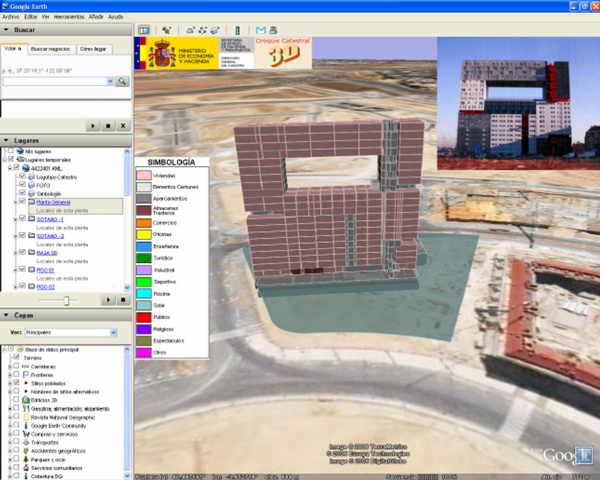
Figure 2. 3D visualisation in
Google Earth (example Spanish cadastre)
2.3 Deliverables and operation
The working group strives to obtain tangible results
that have relevance to the cadastral practice. At the next FIG congress
(2014) we want to publish a FIG publication on guidelines to establish
3D-Cadastres (a 'Primer on 3D-Cadastres'), addressing legal,
institutional and technical issues. In 2011 a second workshop on
3D-Cadastres is planned (again in Delft, 10 years after the first
workshop). In addition, at the FIG working weeks joint commission 3 and
7 sessions on 3D-Cadastes will be organized. Depending on the need and
results, additionally a third workshop on 3D-Cadastres could be
organized in 2013 or 2014 preferably in conjunction with another FIG
meeting (working week, or commission 3/7 annual or congress). Each
workshop will be accompanied by a brief progress report. The exchange of
ideas and discussions will be facilitated by means of a website on
3D-Cadastres. Depending on the issues encountered in our first or second
year of operation a survey of user needs (e.g. by means of a
questionnaire) might be useful.
At the FIG events in the past decade many people have
expressed their interested in 3D-Cadastres. In order to push ahead it
seems best if the specific themes of 3D-Cadastres (legal, institutional
and technical) are lead by a limited number of experts (2-4) who
elaborate on their subject. People can then join these groups for
discussion and preferably contributions. Task of the chair is to start
and encourage these theme-groups, lead the overall issues of working
group, and trigger the necessary events. It seems wise to evaluate this
way of working after one year. Communication during the projects will be
done as much as possible by e-mail and via our dedicated website:
www.gdmc.nl/3DCadastres;
see Figure 3. At the end of each year a progress report will be
available to all members of the interest group and our sponsors in
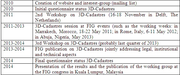
commissions 3 and 7. The Table 1 shows the main events of the working
group in time.
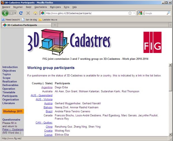
Figure 3. Website FIG 3D Cadastres (with participants and their
completed questionnaires)
Table 1. Timetable with events of
the FIG working group on 3D-Cadastres
3. DESIGN OF THE QUESTIONNAIRE
In this section the design (set-up) of the questionnaire
is presented. No matter how much effort one puts in setting-up a
questionnaire, the experience shows that the questions are always less
clear to the persons/organizations that have to fill in the
questionnaires compared to how clear the questions are to the persons
that created the questions (even if this was a larger team of persons as
in case of the 3D-Cadastres questionnaire). This is caused by the fact
that different terms may have slightly different meaning to persons in
different countries in the world. This is especially true for more
abstract concepts such as 3D Cadastre and 3D parcel. Therefore the first
page of the questionnaire contained a few notes (including an informal
and a formal definition of a 3D parcel) and suggestions, which should be
helpful during the completing the questionnaire. To lower the threshold
to complete (and return) the questionnaire it was also explicitly
expressed that ‘If a certain question is not relevant or if you have no
clue what to respond, do not spend any time on this (and leave the field
blank).’
The formal definition a 3D parcel is defined as the
spatial unit against which (one or more) unique and homogeneous rights
(e.g. ownership right or land use right), responsibilities or
restrictions are associated, as included in a Land Administration
system. As this definition is quite abstract, the questions were phrased
with more descriptive and real world situations included to explain
further. Also two example sets of partial/preliminary answers were
included from Queensland, Australia and The Netherlands, to support the
questions and to be of help when formulating the answers for other
jurisdictions (see Table 2). Despite or due to these preparations during
the period of completing of the questionnaire the organizers received
two requests for clarification.
The questionnaire specifically aims at clarifying the
difference between 3D legal space (referred to as 3D parcel) and 3D
physical objects. A 3D parcel is a ‘legal object’ describing a part of
the space. Often there is a relationship with a real world/physical
object, which can also be described in 3D, but this is not invariably
the case. The questionnaire was framed to recognise the difference
between these two types of objects and that the focus in the context of
3D-Cadastres is on 3D parcels (spaces of legal objects). The
questionnaire has been prepared by the authors of this paper. The
questionnaire was grouped in different thematic blocks. This had no
meaning in the sense of priority and it was often possible that a
question could belong to multiple blocks. The following nine groups of
questions were indentified:
-
General/applicable 3D real-world situations
-
Infrastructure/utility networks
-
Construction/building units
-
X/Y Coordinates
-
Z Coordinates/height representation
-
Temporal Issues
-
Rights, Restrictions and Responsibilities
-
DCDB (The Cadastral Database)
-
Plans of Survey (including field sketches)
The first group of questions refers to the applicable 3D
real-world situations to be registered by 3D parcels. It also addressed
the types of 3D geometries, which are considered to be valid 3D
representations for these parcels. The second group of questions refers
to the situation where an infrastructure network is considered to be
defined within the cadastre. For example in some jurisdictions, an
underground network might be privately constructed for the purpose of
leasing space in it for other organisations to run cabling. In this
case, a network, or part of that network may be considered to be a real
estate object. The third group of questions refers to 3D properties that
are related to constructions and apartment (condominium) buildings. The
individual units are often defined by the actual walls and structure of
a building, rather than by metes and bounds. E.g. “unit 5 on level 6 of
… building”. The other 6 groups of questions are more or less
self-evident. Finally, group 10 the contact details could be provided
together with any other issue that was relevant, but not yet addressed
by one of the earlier questions.
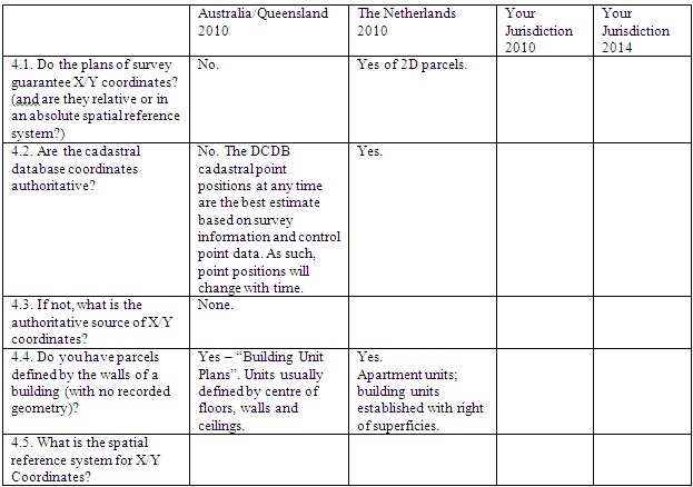
Table 2. Sample form the
3D-Cadastres questionnaire (section 4. X/Y Coordinates) with example
answer from Australia/Queensland and The Netherlands (for the 2010).
The questionnaire was distributed among the member of
FIG 3D-Cadastres WG and the members of FIG joint commission 3 and 7. The
respondents were asked to complete the two empty columns for their
jurisdiction: 2010 (the current status) and 2014 (expectations in 4
years time).
4. AUSTRALIAN PERSPECTIVE
The idea for a 3D-Cadastres questionnaire was first
‘born’ in Australia. Therefore we start by presenting these results.
This questionnaire has been conducted among the eight cadastral
jurisdictions of Australia: Queensland, Australian Capital Territory,
New South Wales, Northern Territory, South Australia, Tasmania, Victoria
and Western Australia (Karki, Thompson, McDougall 2011).. The results
from these are summarised and compared to the international situation.
Generally speaking, the states of Australia have
different procedures, but attempt to have consistent regulations as far
as the public is concerned. This is to ensure that “loop-holes” are not
generated by state differences. Differences, when they occur, tend to be
in the situations that have come into existence more recently. Thus the
first question “Are all 3D parcels constrained to be within one surface
(2D) parcel?” has elicited quite different responses, probably because
situations such as the subdivision of a surface parcel which has a 3D
parcel below it is still a rare occurrence.
4.1 Results of the Australian questionnaire
The range of responses to the Australian questionnaire
was well within the international results (see below), but in summary:
-
All jurisdictions allow 3D parcels to be defined by
metes and bounds (without reference to a physical structure),
-
Alternately all allow parcels to be defined by a
physical structure.
-
All allow a wide range of parcel definitions
(possibly including curved surfaces) providing a precise definition
is made.
-
Dealings involving 3D parcels are effectively the
same as for 2D, but there are some additional restrictions on rights
to units in strata.
-
Moving parcels and temporal boundaries are not
implemented (although there was confusion in some of the replies)
4.2 Differences Between Australian and FIG Responses
In the Australian context, all states support a “heaven
to centre of earth” approach for rights on most parcels. There are
parcels with restricted rights in the form of ownership rights or
encumbrance in the strata. Sometimes even the rights or encumbrances in
strata are sub-divided, amalgamated or nullified. However, distinction
is made between a 2D parcel plan and 3D plan (Volumetric or Building
Format). For a Building Format plan which is used to represent strata,
the database records a 2D surface parcel outline and the various level
details as attributes. For a Volumetric Parcel, easements or leases can
be created for the whole parcel or part of the parcel above or below the
ground.
Below are some of the differences between the Australian
and the International context:
-
Constraints to be within the surface 2D parcel:
In Australia, 2D parcels are subdivided to reflect 3D ownership,
however if the 2D parcels are subsequently subdivided or amalgamated
it does not affect the status of the 3D parcel with then may span
several 2D parcels. 3D easements or leases may exist on part or the
whole of a 2D parcel, may extend to other parcels, may be
subdivided, amalgamated or wholly or partly extinguished and may
have full or partial overlap with another interest.
-
Empty Spaces or Existing Constructions: 3D
rights are permitted as in the case of 3D easements, limited height
parcels or Building Format parcels. For example, an apartment block
which is demolished with the owners rights being reserved for a
replacement on the same level and aspect but not the exact airspace
as before. By contrast a parcel (e.g. a marina parcel) may be
defined by its location in space without reference to any
construction.
-
Boundaries of the 3D parcel: The cadastral
survey requirement is quite explicit in that the 3D parcel
boundaries to be formed must be measurable or definable
mathematically. Volumetric plans and Building format plans deal with
strata quite differently. A Volumetric plan uses an absolute height
(Reduced Level based on the Australian Height Datum) on the surface
while using bearing and distance for the edges, with an isometric
drawing provided. A Building Format plan provides an outline of the
surface parcel, the building footprint and details of each level
while distinguishing between common property and areas of each items
such as the main building, patio, balcony, private yards etc.
-
Registration of 3D parcels in the cadastral
database: 3D registration is supported by the titling system and
3D parcels are registered as either a Volumetric parcel or as a
Building Format parcel. In the digital cadastral database, the
strata are shown as an attribute and all 3D related information
exists in the plan. Building Format plans are not created for every
house, but only those requiring strata title. The title database is
held separately to the cadastral database and updates are part of a
sequential workflow. 3D data is not represented in the viewing tools
of the database.
-
Registration of cable and pipeline networks:
There seems to be quite a number of ways network parcels are
registered in Australia. While some create 3D easements, others
subdivide the surface parcels and some do not capture them on plans.
2D parcels generally have a minimum size restriction determined by
zoning rules but there is no such restriction on the minimum
cross-section size of a 3D parcel.
5. PRELIMINARY ANALYSIS OF THE RESPONSES
In this section, the preliminary analysis of the survey
conducted by the FIG joint commission 3 and 7 working group on
3D-Cadastre, 2010-2014 is presented. In total 36 completed
questionnaires have been received and they are all available at the
working group website (http://www.gdmc.nl/3DCadastres/participants/).
All members of the working group responded with exception of the USA
(until) today: Argentina, Australia, Austria, Bahrain, Brazil, Canada,
China, Croatia, Cyprus, Denmark, Finland, France, Germany, Greece,
Hungary, Indonesia, Israel, Italy, Kazakhstan, Kenya, Macedonia,
Malaysia, The Netherlands, Nepal, Nigeria, Norway, Poland, Russia, South
Korea, Spain, Sweden, Switzerland, Trinidad and Tobago, Turkey, and
United Kingdom. Despite all the efforts to make the concepts used in the
questionnaire and the questions asked as clear as possible, we received
a few requests for clarification by the respondents. This shows the
difficulty (and also the importance) to formulate a clear, standardized
definition for 3D cadastre and 3D parcels that will fit all
jurisdictions.
From the completed questionnaires we received, a number
of conclusions can be made. The first is that despite all the research
in the past year the concepts "3D cadastre” and “3D parcels" are still
ambiguous. The completed questionnaires offer therefore in the first
place an overview of the very different ways in which systems of land
administration deal with the third dimension of rights (or
restrictions). Worldwide there are major differences in those systems,
mostly the result of cultural and historical differences in background,
and these differences influence the organizational, technical and legal
aspects of land registration. Because of these differences, a comparison
of the responses is not always easy.
A general conclusion is that in all jurisdictions, with
the exception of Poland and Nepal, 3D parcels can be registered. But in
most cases these 3D parcels are (or even limited to) apartment units.
That it is not possible to register 3D parcels other than apartment
units in a specific land administration does not mean automatically that
it is not possible to create rights that are limited in the third
dimension. E.g. in the case of South Korea the respondent explicitly
indicated that 3D boundaries of rights are possible by civil law, while
cadastral regulation does not touch this subject. In the following
paragraphs we give an overview of the preliminary analysis of survey
results for several aspects.
5.1 Are all 3D parcels constrained to be within one
surface (2D) parcel?
Most respondents replied on question 1.1 of the
questionnaire that a 3D parcel must be located within the boundaries of
a (2D) parcel. This does not exclude that the building to which the
right refers may be situated on several land parcels. Possibly - as in
the case of the Netherlands - a legal 3D description of right refers to
various 2D land parcels. The responses are not always clear on the
question what will happen if the land parcel is subdivided later. In
Queensland it is the starting point that the 3D parcel must be within
the boundaries of a 2D parcel, but this does not exclude that the 2D
parcel may be subdivided later on. After subdivision the original 3D
parcel continues to exist and therefore stretches out over two or more
land parcels. In Norway and Sweden, 3D properties may be created that
extend over or under different 2D parcels. In Finland this possibility
is foreseen for the future.
5.2 Empty spaces or existing constructions?
An interesting question is whether registration of
rights to empty spaces - such as air spaces or subsurface volumes - is
allowed (e.g. to protect an existing panorama) or that the registered
right compulsory refers to an existing or future construction. This
topic had been addressed by question 1.3. The responses shows that in
most countries explicit rules for this do not exist, but also indicated
that in general the rights will refer to a construction. Explicitly the
possibility of registration of rights for empty spaces are mentioned in
Australia and Canada (Quebec), In Finland this is limited to subsurface
volumes. By contrast, Norway and Sweden the law expressly exclude this
possibility. In these countries there must be a construction, or a
building permit issued for future constructions before a 3D property can
be registered. In Norway 3D parcels can be nullified in the case
construction has not started building the construction that is going to
be the 3D property three years after the building permit has been
issued.
5.3 Boundaries of the 3D parcel
Generally the boundaries of 3D parcels refer to walls,
ceilings and floors. The respondent for France expressly states that -
in the absence of guidelines in this area - virtual boundaries would be
possible. With respect to the z-axis (height) it appears that in the
vast majority of systems directives on this issue does not exist or the
height is not registered. Among the countries that do register the
height (in survey plans or in a legal deed) it may be observed that
Australia and France make use of an absolute level while in Canada
(Quebec) and Sweden reference is made to a height relative to ground
level.
5.4 Registration of 3D parcels in the cadastral
database
3D parcels as such do not exist in any cadastral
registration. The description of the 3D space will be found in the
survey plans or in the legal documents. The standard seems to be that
"floorplans" that the boundaries per floor are listed in the title deed
or the appropriate public records (Land Book, Land Registry, public
records) or survey plans but not in the cadastral database (map). It may
be possibly a make a reference to the 3D parcel in the cadastral map in
the form of a 2D polygon in a single layer as in the case of Australia,
Cyprus (see Figure 4), Croatia (where is spoken of a “2.5D
representation”) , Norway and Sweden.
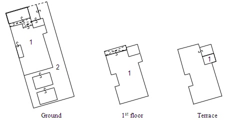
Figure 4. Example from Cyprus:
floor plan with 2 cadastral objects at ground, 1st, and 2nd floor
(terrace)
In Italy 3D Cadastre in Italy is represented by the
Cadastre of Buildings, that exists next to the “Land Cadastre”. This
holds an inventory of every building. A very interesting system of 3D
registration exists in Spain. Here on the cadastral map a 3D model of
the buildings can be shown, including the boundaries of rights inside
the buildings. But this is not a 3D representation of the actual height
of the units. In fact the representation is based on a standard height
of 3 meters from floor-to-floor. Although this is a limitation, this
solution does offer a more or less a realistic view of the buildings and
property rights within buildings in urban areas, see Figure 5.
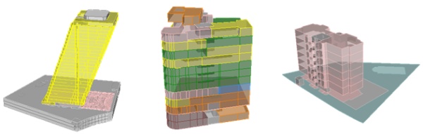
Figure 5. 3D visualisation of
buildings in the Spanish cadastre (based on a standard floor-to-floor
height of 3 meter.
5.5 Registration of cable and pipeline networks
Cable and pipeline networks occupy a special place
within the registered 3D objects and rights. These networks often extend
over several land parcels and thus have - apart from the height or depth
of the structure - a 3D character of their own. In recent years the
Netherlands introduced the possibility to register rights to all types
of cable and pipeline networks. The networks have a cadastral number of
their own. In Switzerland, especially in Geneva networks are included in
the cadastral database in a similar way. In the Russian Federation, a
network can be registered by the Land Registry, but in practice this is
not done. In Kazakhstan, all networks are registered "as legal objects".
However the respondent also mentions that underground networks are not
registered but only shown on maps. Furthermore, in Canada (Quebec) cable
and pipeline networks, rail networks are recorded in public registers
(Register or real right of State resource development). It can be
requested by the owner that the network is displayed on the cadastral
plan, but this rarely happens. The network as such can not be found in
the cadastral database, but indirectly through the land parcels in which
the network is constructed.
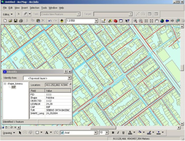
Figure 6. Turkish example ‘3D utility network’: gas (red) and
water (blue) map fragment Istanbul reregistered utility data in
combination with cadastral map; translation: ‘uzunluk’ = ‘length’, ‘cap’
= ‘diameter’,‘tur’ = ‘pressure’; source (Döner e.a. 2010).
In other countries registration of networks does not
happen, or is just possible in limited cases, as in Turkey where only
high voltage power lines are registered in the cadastral database.
Registration of other networks find place at municipal level, and
combined with cadastral data, see Figure 6 example from Istanbul,
Turkey. A general registration of (underground) networks does not exist
in Norway, where telecommunications, water and electricity networks are
not registered, but roads and railways are. Some jurisdictions have
"utility maps” (Australia, Victoria) or a" utility register " as
Croatia. In the latter country is expected that this register will be
integrated in the cadastral database in 2014. Also in other countries we
see developments towards the cadastral registration of networks,
especially in Denmark, Hungary, Israel and Italy. In the latter country
this would take place in the context of pilots projects leading to the
development of a subsurface cadastre.
5.6 Developments in the short term
The purpose of the survey by the FIG Working group was
not only to make a world-wide inventory of the status of 3D-Cadastres at
this moment (2010/2011), but also to get an insight in the expectations
for the near future (2014). However, the planned developments in the
field of 3D cadastre for 2014 seem to be very limited. Whether this
means that one is satisfied with the existing system of 2D registration,
like the respondent for England and Wales expressly stated, remains
unclear. The vast majority of respondents did not answer the questions
one the expected situation for 2014. The most concrete developments
seems to happen in Switzerland, where in 2014 the concept of 3D plots
might be introduced, and Denmark, where the respondent mentions an
ongoing discussion of 3D parcels should be recorded in the cadastre and
a footprint on the cadastral map. Bahrain mentions the future
representation of the apartments in the cadastral database. In recent
years in Israel there has been much research into the development of a
3D cadastre and preparations aimed at legislation and it is hoped that
this will result in practical changes.
6. CONCLUSION AND FUTURE WORK
As indicated, the solutions for registration of rights
with 3D characteristics are very different. Broadly, one can observe
that apartments are registered with drawings in the deed registration.
But a true 3D registration in the cadastre does not exist anywhere. Most
often it was approached by Spain, although the representation uses a
standard height per floor layer.
Techniques for 3D data acquisition, management and
distribution will be within reach. The next step is to optimally exploit
this in order to meet the growing information needs in 3D cadastres,
matching specific organizational and legal contexts. The international
approach of the FIG working group hopes to make an important
contribution to reach this, by the publication of “Primer on
3D-Cadastres” providing guidelines for specific contexts and
implementations, addressing legal, institutional and technical issues.
ACKNOWLEDGEMENTS
The authors of this paper would like to express their
sincere gratitude to the members of the FIG joint commission 3 and 7
working group on 3D-Cadastres for their joint efforts to complete the
questionnaires: Diego Erba, Ali Aien, Don Grant, Mohsen Kalantari,
Gerhard Muggenhuber, Gerhard Navratil, Neeraj Dixit, Ammar Rashid
Kashram, Andréa Flávia Tenório Carneiro, Francois Brochu, Louis-André
Desbiens, Paul Egesborg, Marc Gervais, Jacynthe Pouliot, Francis Roy,
Renzhong Guo, Zhang Ning, Shen Ying, Miodrag Roic, Elikkos Elia, Lars
Bodum, Esben Munk Sørensen, Christian Thellufsen, Jani Hokkanen, Arvo
Kokkonen, Tarja Myllymäki, Claire Galpin, Hervé Halbout, Markus Seifert,
Efi Dimopoulou, Gyula Iván, Andras Osskó, Trias Aditya, S. Subaryono,
Yerach Doytsher, Joseph Forrai, Gili Kirschner, Yoav Tal, Bruno Razza,
Enrico Rispoli, Fausto Savoldi, Natalya Khairudinova, David Siriba,
Gjorgji Gjorgjiev, Vanco Gjorgjiev, Alias Abdul Rahman, Babu Ram
Acharya, Benedict van Dam, Chrit Lemmen, Thomas Dabiri, Lars Elsrud,
Olav Jenssen, Lars Lobben, Tor Valstad, Jaroslaw Bydlosz, Vladimir
Tikhonov, Natalia Vandysheva, Youngho Lee, Amalia Velasco, Jesper
Paasch, Jenny Paulsson, Helena Aström Boss, Robert Balanche, Laurent
Niggeler, Charisse Griffith-Charles, Cemal Biyik, Osman Demir, Fatih
Döner, Gareth Robson, and Carsten Roensdorf. Of course, the authors
remain responsible for the correct interpretation and the resulting
article.
REFERENCES
-
Fatih Döner, Rod Thompson, Jantien Stoter,
Christiaan Lemmen, Hendrik Ploeger, Peter van Oosterom and Sisi
Zlatanova (2010). 4D cadastres: First analysis of Legal,
organizational, and technical impact - With a case study on utility
networks. In: Land Use Policy, Volume 27, pp. 1068-1081, 2010.
-
ISO (2011), ISO 19152. Draft International Standard
(DIS), Geographic information — Land administration domain model
(LADM), Geneva, Switzerland, 20 January 2011.
-
P.J.M. van Oosterom, J.E. Stoter, E.M. Fendel (Eds.)
(2001); Proceedings International Workshop on 3D Cadastres,
Registration of properties in strata, Delft, November 2001,
published by FIG (online www.gdmc.nl/3DCadastres/literature)
-
S. Karki, R.J. Thompson, K McDougall (2011):
Analysis of 3D Cadastral situation in Australia, Unpublished Paper,
2011
BIOGRAPHICAL NOTES
Peter van Oosterom obtained an MSc in Technical
Computer Science in 1985 from Delft University of Technology, The
Netherlands. In 1990 he received a PhD from Leiden University for this
thesis ‘Reactive Data Structures for GIS’. From 1985 until 1995 he
worked at the TNO-FEL laboratory in The Hague, The Netherlands as a
computer scientist. From 1995 until 2000 he was senior information
manager at the Dutch Cadastre, were he was involved in the renewal of
the Cadastral (Geographic) database. Since 2000, he is professor at the
Delft University of Technology (OTB institute) and head of the section
‘GIS Technology’. He is the current chair of the FIG joint commission 3
and 7 working group on ‘3D-Cadastres’ (2010-2014).
Jantien Stoter defended her PhD thesis on 3D
Cadastre in 2004, for which she received the prof. J.M. Tienstra
research-award. From 2004 till 2009 she worked at the International
Institute for Geo-Information Science and Earth Observation, ITC,
Enschede, the Netherlands (www.itc.nl). As associate professor at ITC
she led the research group in the field of automatic generalization. She
was project leader of an EuroSDR project on generalisation from 2005
till 2009. Since October 2009, she fulfils a dual position: one as
Associate Professor at Section GIS technology at OTB and one as
Consultant Product and Process Innovation at the Kadaster. From both
employers she is posted to Geonovum. The topics that she works on are
3D, information modelling and multi-scale data integration. Since
January 2010 she leads the 3D pilot that aims at establishing a 3D
reference model in The Netherlands in a collaboration of 55 partners. In
November 2010 she received a VIDI grant, which is a prestigious award
given by the Netherlands Organisation for Scientific Research (NWO) for
excellent senior researchers
Hendrik Ploeger studied law at Leiden University
and the Free University of Amsterdam, The Netherlands. In 1997 he
finished his PhD-thesis on the subject of the right of superficies and
the horizontal division of property rights in land. He is associate
professor at Delft University of Technology (OTB Research Institute) and
holds the endowed chair in land law and land registration at VU
University of Amsterdam. His research expertise focuses on land law and
land registration, especially from a comparative legal perspective.
Rod Thompson has been working in the spatial
information field since 1985. He designed and led the implementation of
the Queensland Digital Cadastral Data Base, and is now principal advisor
in spatial databases. He obtained a PhD at the Delft University of
Technology in December 2007.
Sudarshan Karki is senior Spatial Information
Officer, Cadastral & Geodetic Data (Survey Information Processing Unit),
in the Data Management & Acquisition, Spatial Information Group of
Department of Environment and Resource Management, Queensland
Government, Australia. He completed his professional Masters Degree in
Geo-informatics from ITC, The Netherlands in 2003 and is currently doing
Master of Spatial Science by Research at the University of Southern
Queensland.
CONTACTS
Peter van Oosterom
Delft University of Technology
OTB, Section GIS-technology
P.O. Box 5030
2600 GA Delft
THE NETHERLANDS
Tel. +31 15 2786950
Fax +31 15 2784422
E-mail:
P.J.M.vanOosterom@tudelft.nl
website http://www.gdmc.nl
Jantien Stoter
Delft University of Technology + Kadaster
OTB, Section GIS-technology
P.O. Box 5030
2600 GA Delft
THE NETHERLANDS
Tel. +31 15 2781664
Fax +31 15 2784422
E-mail: J.E.Stoter@tudelft.nl
website http://www.gdmc.nl
Hendrik Ploeger
VU University Amsterdam, Faculty of Law &
Delft University of Technology
OTB, Section Geo-Information and Land management
P.O. Box 5030
2600 GA Delft
THE NETHERLANDS
Tel.: + 31 15 2782557
Fax: + 31 15 2782745
Email:
h.ploeger@otb.tudelft.nl
Website: www.juritecture.net
Rod Thompson
Queensland Government, Department of Environment and Resource Management
Landcentre,
Main and Vulture Streets,
Woolloongabba
Queensland 4102
AUSTRALIA
Tel. +61 7 38963286
E-mail: Rod.Thompson@qld.gov.au
Web site:
http://www.derm.qld.gov.au/
Sudarshan Karki
Queensland Government, Department of Environment and Resource Management
Landcentre,
Cnr Main and Vulture Streets,
Woolloongabba
Queensland 4102
AUSTRALIA
Tel.: +61 7 389 63190
Fax: +61 7 389 15168
E-mail:
Sudarshan.Karki@derm.qld.gov.au
Web site:
http://www.derm.qld.gov.au/