| |
FIG PUBLICATION NO. 65
The Surveyor’s Role in Monitoring, Mitigating, and
Adapting to Climate Change
FIG Task Force on Surveyors and Climate Change
September 2014
FIG REPORT
Editor: John Hannah
Contributing Authors: Isaac Boateng, Sagi Dalyot, Stig Enemark, Frank
Friesecke, John Hannah, David Mitchell, Paul van der Molen, Merrin Pearse,
Michael Sutherland, and Martinus Vranken
|
 |
This publication is the result of extensive debates, discussions, and
presentations by the FIG Task Force on Surveyors and Climate Change over the
past three years. The Task Force was established at FIG’s Working Week in
Marrakech, Morocco, in May 2011, to facilitate the work of the international
surveying community in deliberating and better understanding how the
surveying profession could contribute and assist the global community in
measuring and monitoring climate change with its sciences, technologies,
professional knowledge, and practices. The Task Force was chaired by
Emeritus Professor John Hannah, New Zealand Institute of Surveyors and
University of Otago. Its
members, with their diverse backgrounds, experiences and expertise, were
drawn from the global community of professional surveyors.
While individual surveyors have had a substantial involvement in climate
change studies for almost three decades, it wasn’t until 2002 that climate
change issues became a formal part of the deliberations within the International
Federation of Surveyors (FIG). The initial emphasis was on climate change and
sustainable development – an emphasis that lead to a number of FIG publications
and declarations. These were then followed by a series of initiatives that were
substantially focused on how the coastal and marine environment should be
managed in the light of likely future climate change. In 2008, an FIG working
group was formed to investigate spatial planning in coastal regions. This
working group, in producing its report in 2010,
noted that from a surveyor’s perspective climate change issues were not
restricted to the coastal zone alone, but rather were diverse and cut across
many other dimensions of the surveyors’ professional activities.
The FIG Task Force on Surveyors and Climate Change set out both to explore
and report on where and how surveyors could assist the global community in
measuring and monitoring climate change, and also to elaborate on the part that
they could play in adapting to climate change and helping to mitigate its
impacts. This publication provides a detailed summary of how the professional
skills of the surveyor can be leveraged to help the global community as it
grapples with the climate change issue. In reading the document it becomes clear
that in many regards surveyors are not only the custodians of enabling
technologies that are critically important to understanding climate change
impacts, but that by virtue of their multi-disciplinary skills, they provide the
bridge across the divide that can often exist between those who work in the
natural sciences versus those working in the social sciences. It is thus a
document that covers a broad spectrum of thoughts and practice, bringing about
the convergence of the spatial and societal aspects of climate change.
The efforts of the Task Force are to be applauded and appreciated. We
acknowledge the efforts and contributions of the authors in providing such a
comprehensive document. It is our hope that it will not only spur surveyors on
to a greater contribution to climate change studies, but that it will also alert
global agencies as to the knowledge and resources that the surveying profession
can bring to the table as climate change policy responses are developed.
CheeHai Teo, FIG President (2011–2014)
John Hannah, Chair, FIG Task Force on Surveyors and Climate Change
EXECUTIVE SUMMARY
The surveyor is a practical, pragmatic, people-centric professional person,
skilled in spatial measurement, able to represent, interpret and analyse spatial
information, highly knowledgeable in the administration and governance of rights
to the land and sea, and capable of planning for the development and use of land
resources. It is this unique combination of skills that allows the surveyor to
not only collect and analyse data vital to understanding the impacts of climate
change, but also to grasp many of the complex human, political and physical
interactions that arise in dealing with climate
change issues.
Understanding the full extent of the complex interactions that are part of
climate change science requires not just ad hoc monitoring of the earth, but
rather integrated earth measurement and monitoring systems, many of which are
satellite based. These data include radar altimetry, gravity, light detection
and ranging (LiDAR), as well as sensors that use reflected or back-scattered
sunlight as their radiation source. Such data can be used not only to provide
detailed information about the terrain, land use patterns, water storage,
ice mass balance and a host of other useful inputs which, when used together,
provide a detailed picture of earth system change, but also to assist with
emergency response and recovery operations after natural disasters. However, in
order for this data to be correctly interpreted and integrated, it is essential
that it not only be time tagged but also given well defined coordinates in a
known reference system. Surveyors not only help define these coordinates and the
reference systems that produce them but also help design and use the software
tools that support the subsequent analyses of the resulting spatial data.
Some years ago the surveying profession recognised that its blend of
professional skills offered a unique platform from which it could help the
global community as it grappled with both climate change and a wider group of
environmental issues. In 2011, following a series of earlier reports, the FIG
formally established a Climate Change Task Force. This publication, which
reflects the primary output from the task force, gives a detailed and
comprehensive analysis of the many ways that surveyors can partner with global
and regional organisations, and States, in confronting and responding to the
climate change challenge.
Facing the Climate Change Challenge
Climate change presents challenges across a broad spectrum of human
activities. In this regard, the surveyor’s skills have particular application in
the following areas.
- The design of urban communities and urban settlements. Being the
home of the largest part of the world’s population, it is in the urban
setting that the impact of climate change is likely to be the most acute.
The surveyor is both the custodian and a user of the digital tools and the
digital databases used in urban planning. These allow the surveyor to
analyse planning options and make policy decisions. Nowhere is this more
apparent than in developing countries where security of land tenure may be
poor and where rapid urbanisation in disaster prone areas leaves people
subject to disaster risk with subsequent loss of livelihood. Many urban
dwellers live in poor quality homes on informally occupied or subdivided
land with little or no protection against climate related disaster events.
The surveyor, being skilled in the definition of land boundaries and having
knowledge of the associated tenure rights (whether formal or informal), can
integrate information with climate resilient urban design processes, thus
vastly improving outcomes for many of the world’s disadvantaged peoples.
- The administration and use of rural areas. Land use is
responsible for more than 30% of all greenhouse gas emissions. Changes in
land use (such as re-forestation) can thus have special importance in
mitigating climate change both by lowering emissions and by removing such
gases from the atmosphere. Additionally, many of the world’s farmers are
smallholders and pastoralists who are being increasingly affected by
changing climate patterns. As they adapt there will be changes to land use
as well as livelihoods. Climate-related migration will become a significant
issue. Many of the strategies suggested for land use change not only require
institutional platforms to promote sustainable land use planning but, just
as importantly, a clear allocation of property rights that provide security
of tenure. Such activities lie at the heart of the surveyor’s professional
skills. With land parcels and their associated rights fully integrated into
land use data bases, governments should incrementally be able to improve
tenure security and controls on poor or inappropriate land use.
- The management of peri-urban areas. Peri-urban areas, which are
found at the interface between city and country where urban and rural uses
of land mix, and often clash, are likely to be affected by climate change
migration. In developed countries these areas are generally managed
intensively so as to prevent urban sprawl and protect agricultural land use.
In developing countries they tend to be areas whose land-use changes rapidly
from rural to semi-urban in relatively short timeframes, as people and
cities respond to urban expansion or migration pressures. In the absence of
long-term policy and planning, and as climate related disasters increasingly
afflict agricultural land, people will tend to migrate to periurban lands,
thus creating a new suite of problems. To what extent will unplanned urban
encroachment be allowed versus the development of planned urban areas? How
will those with existing land rights be treated? What land-rights, if any,
will accrue to new occupants of such areas? Where will new infrastructure be
located? These are questions which the skills of a surveyor are needed to
help resolve.
- The management of the coastal zone. The land-sea interface is the
home of an increasing number of activities, rights and interests, thus
rendering it one of the most complex areas of management. It is here that
sea level rise will have its greatest impact. It is estimated that 10% of
the world’s population live in coastal zone areas that are less than 10
meters above mean sea level. Due to high population densities, shortage of
land, and lack of alternatives, retreat in the face of both sea level rise,
and an increase in the frequency and severity of storms, is exceedingly
difficult. These issues are particularly applicable to Small Island
Developing States
(SIDS) where there is only limited institutional capacity to adapt.
Improving the tenure security of people living on informal tenures (informal
settlements, customary land, tenants and renters), can improve their
resilience to natural disasters and other climate-related impacts. This is
where the surveyor’s experience, knowledge and skills can be of particular
help.
- The use of forest resources. Land use change, predominantly
stemming from the conversion of forests to agriculture, is a large
contributor to carbon emissions. Unspecified property rights over forest
areas, combined with insecure tenure and the allocation of forest land to
commercial users by governments, have led to both widespread deforestation
and the conversion of forest land to other uses. Such activities not only
undermine incentives to improve land productivity and conserve forests but
also lead to dispossession of land for indigenous peoples and forest
dwellers.
In order to help overcome such problems, the UN has devised a programme to
reduce greenhouse gas emissions from deforestation and forest degradation
(REDD and REDD+). Protection of existing ownership and use rights over the
land, natural resources, and the carbon sequestered are critical elements in
the success of these initiatives. Surveyors are helping with tenure
regularization for existing forest dwellers, and with collective titling for
indigenous groups.
- The establishment of carbon credit markets. Articles 6, 12 and 17
of the Kyoto Protocol establish a market for the trading of greenhouse gas
‘assigned emission units’. Carbon trading takes place both at the Chicago
Climate Exchange and in Europe. Apart from this ‘compliance’ market a
voluntary retail offset market has also developed. At issue is the question
as to whether or not an voluntary emission right creates a property right.
Are carbon credit units financial products or property rights? If property
rights, then the surveyor has an important role to play in recording these
rights.
- The development of large scale agriculture. Biofuel production,
as a substitute for fossil fuels, has the potential to expand rapidly. This
will result in greater competition for land access resulting in a need for
better governance of land and resources. Here again secure property rights,
transparent processes and a legal framework to enforce such rights for both
investors and local land right holders are crucial preconditions if
necessary investment is to occur. Additionally, however, the surveyor is
able to use a combination of analysis and precise measurement technology
[Geographic Information Systems (GIS) and Global Positioning Systems (GPS)]
to assist in both defining agricultural management zones and in the optimal
spreading of seeds, biological control agents and fertilisers.
- The development and use of water resources. Climate change will
have significant consequences on the hydrological cycle, and will pose risks
to drinking water supplies. The growing pressure for access and rights to
use the world’s freshwater supplies highlight the need to have well defined
water boundaries and usage agreements between countries, provinces and
neighbouring landowners. Here the surveyor plays a critical role, not only
in defining and mapping the spatial extent of such resources, but also in
determining the spatial extent of their associated covenants and agreements.
Furthermore, when it comes to constructing the infrastructure required to
conserve and deliver water to where it is needed (e.g., dams, canals and
pipelines) it is the surveyor who provides the precise measurement data
needed to ensure the success of such projects.
- The construction of physical infrastructure. Climate change has
the potential to impact significantly on the integrity and reliability of
physical infrastructure such as pipelines, electricity grids and
transportation networks. Not only is spending on the world’s basic
infrastructure in severe deficit (currently amounting to $2.7 trillion/ year
when it ought to be $3.7 trillion/year), but the impacts of climate change
are likely to exacerbate the problems that already exist. Much of this
infrastructure is aged and has not been designed for increasingly severe
weather events. Furthermore, as climate migration occurs, there will be a
commensurate need for the construction of new infrastructure where new
settlement occurs. The construction of the engineering infrastructure used
to meet these human needs require precise spatial positioning – a function
that is solely the domain of the surveyor. The spatial definition of the
land, its acquisition, and the easements necessary to provide legal security
for such infrastructure, is again the domain of the surveyor.
- The use and conservation of energy. CO2, arising from fossil fuel
contributes almost 60% of anthropogenic greenhouse gas emissions. Strategies
for the mitigation of CO2 emissions include improving energy efficiency,
conservation, the use of renewable energy resources, and the clean use of
fossil fuels. Building orientation and design (essential elements in energy
efficiency) can be improved – these being influenced by the shape and
orientation of the underlying land allotments defined by surveyors. Heat
leakage in buildings can be determined by using infrared aerial photography,
and small scale generation (rooftop solar panels) improved. This can be done
by building 3D models of cities using LiDAR scanning technology. This gives
the surveyor the opportunity to define the orientation and surface of
individual rooftops and shadow effects, showing the most favourable spots
for solar panels. In addition, the surveyor’s data integration, spatial
planning, and measurement skills are necessary elements when constructing
large scale facilities for renewable energy generation or the storage of
CO2.
- The spread of disease. Climate change is having an increasing
effect on the spread of diseases that not only affect humans and animals but
also the general ecological environment. The surveyor has both the enabling
technologies that allow the spread of diseases to be tracked and also the
GIS tools that allow various spatially referenced databases (e.g.,
topography, water bodies, insect or animal locations) to be integrated with
statistical and meteorological models thus allowing the prediction of future
infestation or spread.
Surveyors’ Response to the Climate Change Challenge
As humanity seeks to respond to the climate change challenge, and as it
considers this broad spectrum of sectors where the surveyor’s core skills can be
leveraged, several common themes emerge.
Land administration systems. There is an urgent need for cadastral,
land tenure, and land administration systems that fully reflect property rights
and give tenure security to all legitimate landholder. In the first instance,
these systems need to be accessible and able to be integrated with other land
use and climate risk data so that climate change mitigation and adaptation
strategies can encompass the spatial extent and rights of land owners and land
occupiers. In addition, ‘unbundled’ property rights also need to be considered
so that carbon credit titles, for example, can be registered and separated in
land administration systems. Such developments as these are crucial if the
climate related land use changes that will inevitably occur are to work to the
benefit of the human race. Surveyors are not only developing “fit-for-purpose”
approaches that are aimed at all tenures along a continuum of land rights, but
they are also developing formal land administration systems to help with the
demarcation of boundaries, cadastral and participatory mapping of social
tenures, and with the recording of rights.
Spatial monitoring and measuring. Precise spatial measurement, which
is the most traditional and best known skill of the surveyor, assists not only
in monitoring the impacts of climate change but is also an essential element in
adaptation strategies. For example, sea level change analyses require the
precise spatial monitoring of tide gauges, using both conventional levelling
techniques and GPS positioning. Land use decisions and erosion control are
typically based upon detailed topographic mapping that may come from
conventional land surveying techniques, or from laser scanning, or from digital
image analysis. Precision agriculture (an important technique for increasing
crop yields) relies upon GPS measurement technology. The construction of the new
engineering infrastructure needed to support climate change adaptation requires
the use of levelling, total station, and GPS technologies.
Spatial information management. The development of digital land
related databases not only involves the comprehensive collection of relevant
data, but also its integration into a common coordinate framework. This
integration then needs to extend to the integration of social, economic,
environmental and geographical factors so as to allow data mining,
interpretation, and visualisation of different climate change mitigation and
adaptation strategies. These design and integration functions can be undertaken
by the surveyor.
Adaptation and disaster risk management. A range of adaptation
strategies can be embedded into a land administration system so as to control
the occupation and use of land and protect the vulnerable. Furthermore, disaster
risk management and climate change proofing are core adaptation strategies for
the urban environment. The identification of land suitable for the resettlement
of climate refugees, the provision of secure land rights, and then the
development of the necessary infrastructure are all essential tasks that can be
undertaken by a surveyor.
Land-use planning. Long term spatial planning is an essential part of
greenhouse gas emissions reductions. In areas with high levels of land
administration capacity (typically the developed world), energy conservation is
being achieved through improved design processes. In areas with low levels of
land administration capacity, poor records, limited enforcement of land use
policies, and poorly regulated land markets, the challenge is to find innovative
ways for undertaking necessary land use planning.
It is clear that in many regards, surveyors are the custodians of enabling
technologies and systems that are critically important to the future of the
human race. Surveyors provide relevant geographic information for early warning
and climate-related mapping, secure land and natural resource tenure systems to
reduce vulnerability to disasters, and systems for managing urban growth and the
use of land. In this way the surveyor’s work supports climate change adaptation
and mitigation, as well as social justice, economic growth, and environmental
sustainability. However, surveyors recognise that the depth and breadth of the
issues involved in climate change studies (whether scientific, social,
political, or environmental), are of sufficient complexity that
interdisciplinary cooperation is an essential prerequisite to finding robust
solutions. Furthermore, partnerships at local, regional, national and
international levels are essential if integrated, whole of community solutions
are to be found. Surveyors, as land professionals, are committed to partnering
with communities, professional groups,
government agencies and global agencies in order to deliver these solutions.
Editor: John Hannah
Contributing Authors: Isaac Boateng, Sagi Dalyot, Stig Enemark, Frank
Friesecke, John Hannah, David Mitchell, Paul van der Molen, Merrin Pearse,
Michael Sutherland, and Martinus Vranken
Read the full FIG Publication 65 in pdf
Copyright © The International Federation of Surveyors
(FIG) 2014., September2014
All rights reserved
International Federation of Surveyors (FIG)
Kalvebod Brygge 31–33
DK-1780 Copenhagen V
DENMARK
Tel. + 45 38 86 10 81
E-mail: FIG@FIG.net
www.fig.net
Published in English
Copenhagen, Denmark
ISSN 1018-6530 (printed)
ISSN 2311-8423 (pdf)
ISBN 978-87-92853-26-4 (printed)
ISBN 978-87-92853-27-1 (pdf)
Published by
International Federation of Surveyors (FIG)
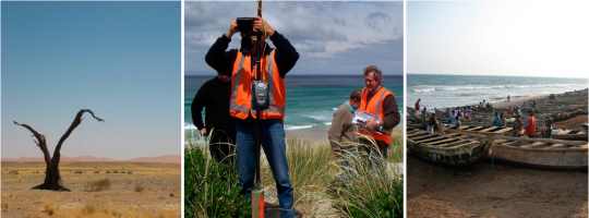
Front cover photos: left and right ©Paul van der Molen,
middle: ©School of Surveying, University of Otago
Back cover photo: ©School of Surveying, University of Otago
Design: International Federation of Surveyors, FIG and Lagarto
|