FIG PUBLICATION NO. 34
AGUASCALIENTES STATEMENT
The Inter-Regional Special Forum
on Development of Land Information Policies in the Americas
26-27 October 2004
Aguascalientes, Mexico
Contents
Preface
Foreword
Aguascalientes Statement
Special Forum Report
1. Special Forum Profile
2. Focus on Land Management
3. Facing the Challenges
3.1 The Educational Challenge
3.2 The Professional Challenge
3.3 The Institutional Challenge
3.4 Capacity Building
4. Findings and Conclusions
Appendices
1. UNRCCA Resolution
2. Special Forum Program
3. Summary of Papers Presented
4. List of Delegates
Orders of the printed copies
This publication is a result of the UN, FIG, PC IDEA
Inter-Regional Special Forum on “Development of Land Information Policies in the
Americas”, held in Aguascalientes, Mexico, 26–27 October 2004. It includes a
report of the Forum and the Aguascalientes Statement as a conclusion of the
Forum.
The Forum was based on a resolution adopted at the Seventh United
Nations Regional Cartographic Conference for the Americas held New York January
2001. The International Federation of Surveyors (FIG) was tasked with taking the
lead role in organizing the special forum with support from the United Nations
Statistics Division, Department of Economic and Social Affairs, and the
Permanent Committee on Spatial Data Infrastructures for the Americas (PC IDEA)
and being hosted by the National Institute of Statistics, Geography and
Informatics (INEGI) in Aguascalientes, Mexico.
We are happy to include this report in the FIG Publication series
as a valuable addition to other joint publications from joint events organized
by the United Nations and FIG. These include the Bogor Declaration from the
United Nations Interregional Meeting of Experts on the Cadastre, 1996; the
Bathurst Declaration on Land Administration for Sustainable Development, 1999;
the Nairobi Statement on Spatial Information for Sustainable Development, 2001
and the Marrakech Statement on Urban-Rural Inter-relationship, 2003.
On behalf of the organizers of the Forum we would like to express
our special thanks to Prof. John Parker and Prof. Stig Enemark for their great
work with this report and for organizing the Forum.
Univ. Prof. Dr.-Ing. Holger Magel
President of FIG
The aim of the UN, FIG, PC IDEA Inter-Regional Special Forum on
“Development of Land Information Policies in the Americas” was to emphasize the
importance for governments to develop land policies that effectively and
efficiently incorporate appropriate spatial data infrastructures (SDI’s) due to
the economic and social value that results from integrating the land
administration/cadastre/land registration function with the topographic mapping
function.
The special forum was based on a resolution adopted at the
Seventh United Nations Regional Cartographic Conference for the Americas held
New York January 2001 (see Appendix 1).
The organizers wish to thank all who participated, contributed,
supported and encouraged the special forum which has resulted in this
‘Aguascalientes Statement’. It is gratefully acknowledged the support and
funding provided by the Canadian Government through Natural Resources Canada,
the United States of America Government through USGS/FGDC and USAID, the World
Bank through the Danish Trust Fund, and the Pan American Institute of Geography
and History (PAIGH).
Sincere thanks to INEGI for making available their excellent
facilities and to the many people in INEGI who supported and assisted with the
Special Forum. Finally, we wish to convey our sincere gratitude and thanks to
all the delegates who traveled from all parts of the Americas to attend the
Special Forum and who participated so actively and enthusiastically.
This report of the Special Forum will be tabled at the Eighth
United Nations Regional Cartographic Conference for the Americas to be held in
June 2005 in New York. This should assist member States to develop appropriate
institutional, legal and technical processes to integrate land administration
and topographic mapping programs within the context of a wider national strategy
for spatial data infrastructure.
Professor John Parker
Special Forum Organizer |
Professor Stig Enemark
Co-organizer, Vice-President FIG |
The objective set forth by this Forum was to raise awareness on the
importance of fostering modern land policies associated with spatial data
infrastructures and on the value of integrating land administration, cadastre
and land registration functions with topographic mapping.
The Special Forum agreed that sound land information policies are essential
to sustainable development.
The Special Forum strongly endorses the need for Latin American and Caribbean
countries to:
- Foster modern land policies and associated spatial data infrastructures so
as to better support social, economic and environmental sustainability.
- Determine policies and programs for educational, professional, and
institutional capacity building that will ensure the development of
appropriate land administration systems and associated spatial data
infrastructure.
- Develop appropriate institutional, legal and technical processes to
integrate land administration, cadastre and land registration functions with
topographic mapping programs within the context of a wider national strategy
for spatial data infrastructure (SDI).
All sessions discussed and covered these issues in full. Several countries
reported their experience when implementing these measures. This Forum has
undoubtedly provided a global understanding of land administration and SDI’s
development and has enhanced the knowledge to make intelligent decisions for the
benefit of the Americas.

Aguascalientes – the bull ring
© Stig Enemark
Aguascalientes Statement
The Inter-Regional Special Forum on Development of Land
Information Policies in the Americas
International Federation of Surveyors FIG
January 2005
ISBN 87-90907-41-8
There are difficulties being faced by many United Nations member States in
designing appropriate spatial data infrastructures to support effective land
administration, and in integrating cadastral and topographic spatial data,
especially in digital form. Therefore, there is a need to improve capacity to
design, build and manage land administration systems, which incorporate
appropriate spatial data infrastructures.
In many cases there is a lack of understanding of the important role spatial
information (i.e. information that provides location on the earth, e.g. to allow
accurately plotting on maps) plays in land administration projects, particularly
in developing countries.
In many countries the land ownership and registration function is located in
one department e.g. the justice or legal department of government, while the
geodetic survey and mapping function is located in another department, and often
has very little if anything to do with the ownership and registration function.
When a land administration project is initiated and funded, say by the World
Bank, the government’s institutional arrangements of departments can make it
very difficult to access information and involve the skills and knowledge
between different departments, e.g. between the survey and mapping functional
area and justice and legal functional area.
With this background the objective of the special forum was:
- To establish an awareness of the economic and social value for decision
makers, of the importance of developing land policies that effectively and
efficiently incorporate appropriate spatial data infrastructures;
- To develop an overall understanding of the value of integrating the land
administration/cadastre/land registration functions with the topographic
mapping function.
The program of the special forum consisted of four key-note presentations
followed by some case studies from various regions of the world, and a number of
case studies from the Latin American countries (see
Appendix 2). The case studies followed a common format in order to ensure
consistency and contextual focus. Sessions were allocated to discussions of the
case studies and for short presentations and discussions on the challenges
facing the Americas with respect to the theme of this forum. These provided the
opportunity for those attending to either comment on a presentation or provide
some insight into the situation within their own country. A list of papers with
summary abstracts is presented in Appendix 3. The full
papers and the PowerPoint presentations are available in English and Spanish at
the FIG website.
There were about 60 delegates from 18 countries together with representatives
from the United Nations, FIG, PC IDEA, World Bank, and PAIGH. A list of the
delegations can be found in Appendix 4.
Land Management is a very complex and interdisciplinary concept that includes
a mix of technical, natural, and social sciences. Land management can be
described as the processes by which the resources of land are put into good
effect. It is about land policies, land rights, property economics, land-use
control, regulation, implementation, and development. Land management
encompasses all those activities associated with the management of land as an
asset and a resource to achieve sustainable development.
Within the country context, the land management activities may be described
by the three components: Land Policies, Land Information Infrastructures, and
Land Administration Functions in support of Sustainable Development.
A modern land administration system acts within the environment of adopted
land policies that fulfill political objectives with regard to land issues. It
also acts within an institutional framework that imposes mandates and
responsibilities on the various agencies and organizations. Basically such
systems are embedded in the historical, cultural and judicial setting of the
individual country. However, in spite of the different origins the systems seem
to merge into a global model serving some basic societal needs. Such a global
model is shown in the diagram below.
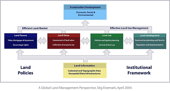
The operational component of the land management paradigm is the range of
land administration functions that ensure proper management of rights,
restrictions and responsibilities in relation to property, land and natural
resources. These functions include the areas of land tenure (securing and
transferring rights in land); land value (valuation and taxation of land and
properties); land-use (planning and control of the use of land and natural
resources); and land development (utilities, infrastructure, construction
planning, permits, and implementation).
The land administration functions are based on and are facilitated by
appropriate land information infrastructures that include cadastral and
topographic datasets and provide access to complete and up-to-date information
of the built and natural environment.

Urban environment – Zacatecas, Mexico.
© Stig Enemark
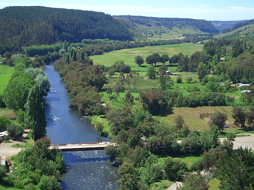
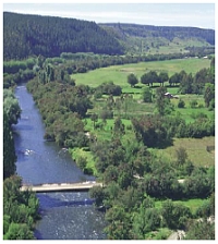
Rural environment – Concepcion Province, Chile.
© Stig Enemark
The information on land and properties permeates through the overall system
and provides the basic infrastructure for running the administrative systems
within the four interrelated areas. The land information area should be
organized to combine the cadastral and topographic data and thereby linking the
built environment (including the legal land rights) with the natural environment
(including environmental and natural resource issues). Land information should
be organized as a spatial data infrastructure at national, regional and local
level based on relevant policies for data sharing, cost recovery, access to
data, standards, etc. It is generally recognized that about 70 per cent of all
government information is geospatially based.
Sound land management is the operational processes of implementing land
policies in a comprehensive and sustainable way. In many countries, however,
there is a tendency to separate land tenure rights from land-use rights. There
is no effective institutional mechanism for linking planning and land-use
controls with land values and the operation of the land market. The problems are
often compounded by poor administrative and management procedures that fail to
deliver the services that are needed. Investment in new technology will only go
a small way towards solving a much deeper problem, which is the failure to treat
land and its resources as a coherent whole.
The modern land administration system is concerned with detailed information
at the individual land parcel level. As such it should service the needs of both
the individual and the community at large. These ambitious goals will not be
achieved unless there is a commitment to designing and implementing effective
land administration infrastructures. These may be described as the
organisations, standards, processes, information and dissemination systems and
technologies required to support the allocation, transfer, dealing and use of
land. Information technology will play an increasingly important role both in
constructing the necessary infrastructure and in providing effective citizen
access to information.
Spatial data infrastructures in a land management framework provide
mechanisms for sharing geo-referenced information. Key elements include adoption
and implementation of technical standards, adoption of access policies and cost
recovery policies, and design of co-operative relationships between governmental
levels and between the public and private sector. The governmental initiatives
and policies on Geospatial Data Infrastructures should establish these
mechanisms and thereby coordinate and integrate the basic building blocks of a
National SDI: the digital registers and maps at various levels and the necessary
logical data models that facilitate an integrated utilization and availability
of the data.
By creating an infrastructure and the relevant linkages positive results will
emerge. Clear responsibility for data maintenance and upgrade will be
established, duplication will be reduced and analysis improved. Sound
decision-making processes are developed for governments at all levels, and
valuable information is created for academic institutions, the private sector
and the community.
Good land management will help promote economic and social development in
both urban and rural areas. For developing and transition countries, land reform
policies are key components in achieving these goals. The challenges in this
regard relate to educational, professional, and institutional issues.
Traditional education of surveyors has focused on geometry and technology
more than on land use and land administration. Taking a land administration
approach to surveying education, there is a need to change the focus from being
seen very much as an engineering discipline. There is a need for a more
managerial and interdisciplinary focus as a basis for developing and running
adequate systems of land administration. A future educational profile for land
administrators should consist of Measurement Science and Land Management and
supported by and embedded in a broad interdisciplinary paradigm of Spatial
Information Management. Such a profile is illustrated below.
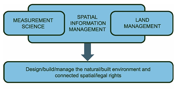
The educational profile of the future.
© Stig Enemark
With few University programs in Land Management, the Latin American and
Caribbean region is lacking experts to support systems of sustainable land
administration infrastructures. There is a need to develop comprehensive
University programs with a broader profile than a technical focus. And there is
need to share efforts and information between educational institutions in order
to serve the basic land administration needs in the region. Donors such as the
World Bank and other aid agencies where they are building land administration
systems should include the educational component to ensure long term
sustainability.
The spatial information revolution and the evolving land management paradigm
in support of sustainable development have had many influences on education and
professional structures over the last two decades. The international surveying
profession and the national associations will have to adapt to these challenges
and develop structures that accommodate a modern interdisciplinary profile. This
includes adoption of ethical principles and model codes of professional conduct
suitable for performing this modern role.
The profile of the land management profession in the third millennium will
include a mix of technical surveying and mapping professionals, business
practitioners, spatial data managers, land and environmental resource managers
(in the public as well as the private sector), and legal and financial
consultants on land management matters.
In many Latin American and Caribbean countries there is a need to establish
professional associations that can set standards, enforce professional
development, and interact with sister associations within the region and world
wide through international NGO’s such as FIG. This will increase awareness about
regional and global opportunities for technological development and transfer,
institutional strengthening, and the exchange of managerial and SDI experiences.
Establishing appropriate institutional and organizational infrastructures is
seen as a crucial key for achieving sustainability in any society. In a
theoretical sense, the concept of property rights is such an institution.
Appropriate cadastral systems play a most important role in terms of
facilitating the real property transactions such as land transfers, land
taxation and control of land use and land development. A fundamental
institutional challenge in this regard is related to understanding the value of
developing appropriate institutional, legal and technical processes to integrate
land administration and topographic mapping programs within the context of a
wider national land policy.
Similar to developed countries, developing countries in Latin America and the
Caribbean need current and reliable data, and need to define standards and adopt
policies to access information, but they also face different priorities. These
include the need for capacity building, institutional development, and
sustainable funding solutions. Institutional reforms will be pushed by increased
demands for information to support sustainable development. But it will take
time. Good land administration systems and good governance will improve the
quality of life of a nations citizens.
It is understood that one model will not fit all countries. In spite of
sharing much the same geography and history, the Latin American and Caribbean
region shows diverse approaches to land information and land registration
systems, as well as to the building of spatial data infrastructures. Such
systems are embedded in the institutional development of the country or
jurisdiction and the institutional arrangements may change over time to better
support the implementation of land policies and good governance.
Capacity building is increasingly seen as a key component of land
administration projects such as World Bank projects in developing and transition
countries. However, the capacity building concept is often used in a very narrow
meaning such as focusing on staff development through formal education and
training programs to meet the deficit of qualified personnel in the actual
project in the short term. This conventional understanding has changed over
recent year towards a broader and more holistic view covering social,
organizational and educational aspects. Capacity Building therefore is a broader
concept than just Human Resource Development since it includes an emphasis on
the overall system, environment and context in which individuals, organizations
and societies operate and interact.
Where a donor project is established to create land administration
infrastructures in developing or transition countries, it is critical that
capacity building is a main stream component that is addressed up front, not as
an add-on. In fact, such projects should be dealt with as capacity building
projects in themselves. While attention should still be given to doing the
project, the key focus should be on building capacity to meet the medium and
long term needs.
In this regard attention should be given to sustaining existing educational
facilities in terms of institutional development, quality management, and
financial support. Attention should also be given to the development of one or
more Regional Centers in the Latin American and Caribbean region for Education
and Research in Land Administration. Such centers should act as ongoing bodies
of knowledge and experience in land administration and using actual projects as
long-term case studies and operational laboratories. The centers should provide
educational programs and supervise establishment of educational programs at
other institutions. The centers should develop guidelines for capacity
assessment in land administration and interact with national institutions,
international academics and professional bodies to assist regional and local
development serving regional and local needs.
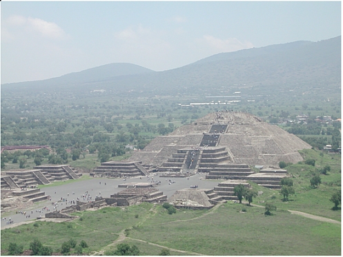
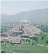
Ancient pyramid – Mexico.
© John Parker
The Special Forum discussed and took note of the major challenges faced by
the Latin American and Caribbean region for the creation and maintenance of land
administration infrastructures for poverty reduction, economic growth, and
sustainable development. The presentations from various Latin American countries
were very different, as experiences depend on social and cultural factors.
However, most countries in the region seem to share the same needs in terms of
capacity building for educational and institutional development in land
administration. Key findings and conclusions are highlighted below:
- It is important that the countries in the region develop a wider vision
for the creation of knowledge, reduction of poverty, and sustainability. In
this regard, it is time to handle change and to convince politicians and
decision-makers.
- The need to formulate national policies, legal frameworks, and standards
for land administration, land information and spatial data infrastructure is
widely acknowledged.
- It is important to demonstrate the economic value of land administration
systems and SDI’s to high-level decision-makers, considering the large number
of priorities they are facing. This should be based on further case studies
from the Latin American and Caribbean region.
- Visionary leadership and also short term initiatives such as shared data
collection projects are recognized as important to establish
inter-organizational and inter-regional cooperation. It is necessary to ensure
coordination between the key players, and to break down human, technical and
political barriers.
- It is important to have a focus on the users needs in order to build trust
amongst the beneficiaries of the systems. Credibility and transparency must be
built into the processes, including institutional continuity and continuous
modernization.
- The need for capacity development of human resources through the building
of programs for education and training in land administration must be
reinforced. This also applies to the establishment of national professional
bodies to interact at regional and global level.
- There is a need to integrate land administration, cadastre and land
registration functions with topographic mapping programs within the context of
a wider national strategy for spatial data infrastructures.
The conclusions can be summarized in the “Aguascalientes Statement” as
presented earlier in this publication. The Special Forum recommends that
politicians and decision makers at various levels take note of this statement
and make efforts to ensure its implementation.
UNRCCA Resolution
In January 2001 the United Nations held its Seventh Regional Cartographic
Conference for the Americas in New York. The conference carried the theme of
‘Spatial data and development: building a sustainable infrastructure’. A product
of the conference was a number of resolutions, one of which was on ‘Land
Administration and Spatial Data Infrastructures’. The resolution stated:
“The conference,
Recognising the importance of efficient and effective land
administration systems in supporting the development of land markets, in
providing security of tenure and access to land, in facilitating the provision
of credit to farmers, in ensuring equitable land taxation, promoting better land
use planning and more generally in promoting economic development, social
cohesion and sustainable development,
Recalling the deliberations of the Sixth United Nations Regional
Cartographic Conference for the Americas on the need to better understand and
appreciate the relationship between land administration and spatial data
infrastructures,
Noting the difficulties being faced by many member States in
designing appropriate spatial data infrastructures to support effective land
administration, and in integrating cadastral and topographic spatial data,
especially in digital form,
Further Noting the generous offer of the Government of Mexico to
host a special workshop on the integration of Spatial Data Infrastructure (SDI)
initiatives and Cadastral activities, along with the 4th Permanent Committee on
SDI for the Americas (PC-IDEA) Meeting,
Also Noting the need to improve capacity to design, build and
manage land administration systems which incorporate appropriate spatial data
infrastructures
Supports the resolutions of the Fifteenth UNRCC for Asia and the
Pacific, Kuala Lumpur, 11–14 April, 2000 and in addition endorse the United
Nations-International Federation of Surveyors Bathurst Declaration on Land
Administration for Sustainable Development,
And requests United Nations Secretariat, within available resources
and with the support of the Permanent Committee on SDI for the Americas
(PC-IDEA) and the International Federation of Surveyors, to provide support on
the program of the inter-regional workshop to be hosted by Mexico to determine
policies and programs for educational, training and professional capacity
building that will ensure the development of appropriate land administration
systems and associated spatial data infrastructures,
And Recommends that member States develop appropriate
institutional, legal and technical processes to integrate land administration
and topographic mapping programs within the context of a wider national strategy
for spatial data infrastructure.”
Summary of Papers Presented
Full papers and powerpoint presentations in English and Spanish are available
at http://www.FIG.net/pub/mexico.
Keynote Papers
Canada: Mr. John Efford, Minister of Natural Resources Canada represented by
Dr. Irwin Itzkovitch
• Building Land Information Policy/Land Information Governance
In Canada, geospatial information affects almost every aspect of our daily
life – even if Canadians are largely unaware of its applications. A base layer
of Canada’s land information structure is the property parcel, which provides a
window of access to vast amounts of thematic geospatial data. Governments,
businesses and citizens use location-based information in making decisions that
affect the economy, the environment and our way of life. The challenge is to put
the tools of geospatial data into the hands of Canadians who can use them — not
the geomatics and geospatial experts, but the hundreds of thousands of citizens
who can use geospatial data in their daily jobs and to improve their lives.
FIG: Stig Enemark, Denmark
• Building Land Information Policies
The paper presents a conceptual understanding in the areas of Cadastre, Land
Administration, and Land Management as a basis for building adequate land
information policies. To develop this understanding the paper looks at each area
as a system or an infrastructure designed for handling specific tasks and
serving specific needs in society. The paper analyzes the function and the basic
elements of the systems and looks at the interaction between the four key areas:
land tenure, land value, land-use, and land development. Finally the paper
explores the key challenges to be faced by the politicians in this area. These
challenges relate to educational, professional, institutional, and capacity
building issues.
World Bank: Klaus Deininger (presented by Frederic de Dinechin)
• Land Policy for Growth and Poverty Reduction: Key Issues and Challenges
Ahead
The paper focuses on the broad conclusions from recent research on land
issues It argues that well-defined and secure land rights are critical to
provide incentives for investment and sustainable resource management, to
facilitate low cost transfers of land and credit access as the rural non-farm
economy develops, and to allow provision of public services at minimum cost.
Based on a review of the historical evolution of property rights, the paper
outlines channels through which the nature of such rights, the way in which they
can be exchanged, affect economic growth, poverty reduction, and governance. For
each of these areas, policy actions that can help to improve the security of
land rights, reduce the cost of exchanging them, and promote socially desirable
land use are outlined.
PC IDEA: Mario Reyes Ibarra, Mexico
• Administration of Spatial Information in the Americas
International economic and social development is currently facing a number of
challenges that require the adoption of new schemes and paradigms associated
with globalization and sustainable development. One of such challenges is to
make the most and best use of available statistical and geographic information.
CP IDEA is an organization focused on articulating common interests in the field
of geographic information to develop national GSDIs that will integrate into a
regional and global context. There should be a response to the increasing
demands imposed by globalization, sustainable economic development and growing
technological progress.
International Case Studies
Europe: Paul van der Molen, FIG Commission 7
• Good Administration of Land in Europe
Europe’s history resulted in a variety of nations, with various policies
regarding the land issue and with a diversity of land administration systems.
The organization of the public administration reflects different views on the
role of the State and the division of power between central and local
government. Despite all differences however, these nations also have something
in common: land policies are in place and so have systems of land
administration. There are two drivers. The first is the need for quality
information for decision support. The second is the optimization of the return
on investments in public information availability.
Australia: John Parker
• Land Management in Australia – Case Study with Emphasis on the State of
Victoria
Australia is a federation and operates separate cadastral systems in each
state and territory. These have played a significant role in shaping Australia’s
development. Initially they provided registration of ownership for land
settlement. Then, by providing security for land transfers, they assisted
establishment of a successful and complex land market. The cadastral systems
have recently evolved into comprehensive instruments for assisting economic,
environmental and social decision making. This is shown in broadening land
tenure arrangements, recognition of traditional Aboriginal land rights, and use
of new technologies to integrate cadastral information as a foundation of
spatial information systems.
Canada: David Coleman
• Examining the Role of Partnerships in Building a Canadian Geospatial Data
Infrastructure
Canadian federal and provincial government organizations have long been
engaged in building and maintaining extensive collections of digital topographic
mapping datasets, road network files and property mapping databases in support
of their own respective mandates and obligations. Since 1996, a collection of
these organizations has been instrumental in establishing and developing the
Canadian Geospatial Data Infrastructure (CGDI) Initiative. The paper examines
the nature and status of selected partnerships and institutional arrangements
designed to help build the Canadian Geospatial Data Infrastructure.
Latin American Case Studies
El Salvador: Garrid Safie
• Building Land Information Policies in El Salvador
Land administration commenced in 1932, when the Government of El Salvador
started developing a Policy aimed at facilitating peasants’ access to land by
different programs. Cadastral activities were started by end 1963 but the
National Cadastre was created only in 1970. In 1974, a Legislative Decree
prescribed that the cadastre implementation was of public interest. The Land
Information System’s main objective is to integrate land information authorities
and functions so as to overcome difficulties derived from scattered
institutional efforts. The CNR should be responsible for maintaining one single
technical platform, under the guidance of the National Cadastre and Institute.
Mexico: Mario Reyes Ibarra
• Building on an Experience, the Participation of INEGI in PROCEDE – A Case
Study in Mexico
After twelve years of participation in a nationwide program to provide rural
land registration in Mexico, INEGI has been able to build up expertise in
several fields of geographic, geodetic, mapping and cadastral knowledge. The use
of very modern technologies related to land surveying also streamlined INEGI’s
methodologies, reduced the time spent on field works, enhanced accuracy and
reduced error margins for the data captured under uniform standards. Meanwhile,
the setting up of a network of IT centers for mapping production and development
of large databases, as well as their integration, access and exploitation by
Geographic Information Systems, are key components of the Spatial Data
Infrastructure in Mexico.
Chile: Rodrigo Barriga
• Territorial Information Management in Chile
Chile, through its National System of Land Information (SNIT, its acronym in
Spanish), is currently making institutional efforts to consolidate its
Geospatial Data Infrastructure. These efforts are supported by a Policy
initiative based on the principles of transparency, institutional cooperation,
decentralization and by the active participation of the Administrative Regions
and the efficient and effective use of resources involved in the utilization of
geographic information. All this is focused on modernizing Land Information
Management in Chile, in accordance with countrywide efforts for the State to
reform and modernize, achieve transparency, economic growth and social
development.
Brazil: Dr. Eduardo Pereira Nunes
• A Case Study in Brazil: The Main Challenges Faced by Land Administration
The paper analyses land administration in Brazil, existing land policies and
available land information to proceed and audit main problems and current
barriers. The author also reports on issues related to the decision of a land
administration plan that needs to be integrated at federal, state and municipal
level. Besides, the author also reports on resource allocation to provide for
the modernization of basic mapping production.
|