| |
FIG PUBLICATION NO. 30
THE
Nairobi statement on spatial information for sustainable development
In co-operation with the United Nations

 This publication in .pdf-format
Contents
Foreword
Executive Summary
1. Introduction
2. Sustainable Development
3. Spatial Data and Spatial Information
4. Spatial Data Infrastructure
5. FIG Involvement
6. United Nations Activities Related to Spatial Data
7. Recommendations
7.1. The National Perspective
7.1.1.
National Organisations
7.1.2.
National Policies, Strategies and Implementation
7.1.3.
Legal Aspect
7.1.4.
Capacity Building
7. 2. The Regional Perspective
7.2.1.
Regional Strategies and Activities
7.3. The Global Perspective
7.3.1.
UN-ECA and the African Countries
7.3.2.
Technology Transfer - The Role of the Vendors
7. 4. The FIG Perspective
7.4.1.
FIG Specific Recommendations
Appendix A
A1. Literature
A2. Links
Appendix B
Experiences and Visions for the 21st Century
Appendix C
C1. The History of and the Partners
behind the International Conference on Spatial Information for
Sustainable
Development
C2. Sustainable Development
C3. Spatial Data and Spatial Information
C4. Spatial Data Infrastructure
C5. FIG Involvement
C5.1.
The Bathurst Declaration
C5.2.
FIG Agenda 21
C6. United Nations Activities related to
Spatial Data
C6.1.
The Regional Cartographic Conference for the Americas
C6.2.
Meeting of the Committee on Development Information
C7. FIG Commission 3 - Spatial
Information Management
C7.1.
Work Plan 1998-2002
Orders of the printed copies
The International Conference on Spatial Information for Sustainable
Development, held in Nairobi, Kenya 2-5 October 2001, was organized by the
Institution of Surveyors of Kenya, the International Federation of Surveyors
(FIG) and the UN-Habitat.
The conference became a reality because of support and help from the main
sponsors United Nations Environmental Program (UNEP), GEOMAPS Ltd. Surveying
and Mapping and Institution of Quantity Surveyors of Kenya, the co-sponsors
Metrocosmo Valuers Ltd, University of Nairobi, Intergraph Mapping and GIS
Solutions and Swedesurvey AB and a number of companies and institutions who
have contributed in one way or another. In addition the United Nations
Economic Commission for Africa and United Nations Food and Agriculture
Organization were active participants /C1/.
Spatial Data Infrastructure and Spatial Information Management is clearly
in the focus for all surveyors and other stakeholders worldwide in their
diverse tasks in development, planning and resource management and in their
efforts at creating and supporting a Sustainable Development.
The conference offered the speakers as well as the participants the
opportunity to focus on, discuss and share experiences on issues and topics
related to Spatial Information for Sustainable Development in general and in
Africa in particular.
The conference concentrated on the following sub-themes: i) Spatial Data
Infrastructure and Spatial Information Management, ii) the role of Spatial
Information in land tenure, land administration and spatial planning iii)
low cost housing and iv) Spatial Information, education and best practices.
In total there were more than 80 presentations. Some were based on
research and developing trends, others were based on projects and
experiences. /10/
The outcome of the Conference is a number of recommendations on actions
necessary for establishing a Spatial Data Infrastructure.
This publication, which includes the conference recommendations, is
intended to support politicians, senior managers and professional
organisations by providing greater understanding of the need for Spatial
Data Infrastructures (SDI's) and how they can be used to support Sustainable
Development. Even though the recommendations are based on African conditions
they are easily transformed to general terms are therefore applicable to all
regions of the world.
Robert W. Foster
President of FIG
Jes Ryttersgaard
Chair of FIG Commission 3
The Nairobi Statement on Spatial Information for Sustainable
Development
2nd - 5th October 2001
Nairobi Kenya
International Federation of Surveyors FIG
in co-operation with
THE UNITED NATIONS
February 2002
The objectives of the Nairobi Conference on Spatial Information for
Sustainable Development /10/ were to:
- Contribute to the international community's effort to advance the
implementation of UN Agenda 21 (www.un.org/esa/sustdev)
and the Habitat Agenda (www.unhabitat.org);
- Understand the role of the surveying community in implementing the
Habitat Agenda;
- Urge governments and stakeholders to implement integrated land
information management;
- Strengthen and promote the relevant information to support FIG Agenda
21.
The conference recognized, against a background of presentations and
discussions and the outcome from other international conferences, workshops
and taskforces, that development and implementation of a National Spatial
Data Infrastructure is a prerequisite for promoting Sustainable Development.
The conference also recognized that although every National Spatial Data
Infrastructure (NSDI) is different due to a variety of cultural, social and
economic factors unique within each country, there are a significant number
of common elements that can be shared.
It is recognized that a key success factor of implementing NSDI is the
management of information as an asset, as in the case with finance and human
resources. Mature NSDIs are complex solutions involving a number of
stakeholders. However, those who have a NSDI have started with clear
short-term objectives and corresponding simple solutions. The use of Spatial
Information to support Sustainable Development will only be achieved if
solutions start with realistic objectives and grow incrementally through
political and market needs.
Many of the key infrastructure requirements of NSDI, e.g. pervasive
telecommunications and internet access are not widely available in some
countries, this limits the applicability of leading edge NSDI technical
solutions. Vendors are encouraged to understand the needs of developing
countries and design and market appropriate technical solutions.
NSDIs are underpinned by effective partnerships and co-operation amongst
a wide variety of multi-disciplinary stakeholders in public and private
sectors and the end user communities.
Countries are encouraged to form appropriate policy and institutional
frameworks and facilitate co-operation amongst stakeholders. The creation of
a 'proof of concept application' can be used to gain and continue political
support whilst feeding into the formulation of NSDI policy and strategy.
Special attention should be given to the following recommendations:
- African countries are encouraged to form National NSDI Steering Groups
to formulate appropriate policy and institutional frameworks and
facilitate co-operation amongst the stakeholders.
- African countries are encouraged to design solutions that start with
realistic objectives and grow incrementally through political and market
needs.
- African countries are recommended to establish regional co-operation
through joint initiatives that require regional information management to
support common interests.
- The Commission on Developing Information (CODI) proposal for UN-ECA to
establish a Permanent Committee for NSDI in Africa is strongly supported.
1. Introduction
This publication, which includes the conference recommendations, is
intended to support politicians, senior managers and professional
organisations by providing greater understanding of the need for National
Spatial Data Infrastructures (NSDI) so that Spatial Data and Information can
support the implementation and maintenance of Sustainable Development
effectively.
A major part of data and information necessary for Sustainable
Development refers a particular geographical location somewhere on the
Earth. Data and information with a reference to a specific location is
called Spatial Data and Spatial Information respectively. Spatial Data and
Information is strategically important to decision makers at all levels as
it affects a major part of all human decision-making.
The information requirements for supporting Sustainable Development
involve the integration of a number of different types of data from diverse
sources, including: land administration, socio-economic, environment, and
development. Through common spatial referencing standards enforced by NSDI,
these data can be interchanged and integrated to encourage a more holistic
approach to decision making involved in Sustainable Development.
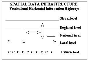
The information requirements for managing Sustainable Development require
datasets to be available locally, nationally, regionally as well as
globally. There is therefore a need to create a 'vertical information
highway' to allow transaction based information to be generated through
administrative activities at the local level, e.g. land registration, to be
aggregated through the local - national - regional and global levels. This
approach to recycling information through different levels of Spatial Data
Infrastructures will ensure that datasets are current and compatible. The
Spatial Data Infrastructures can be the 'land information engine' to support
this vertical information highway.
Mature NSDIs are complex solutions involving a number of stakeholders.
However, those who have a NSDI have started with clear short-term objectives
and corresponding simple solutions. The use of Spatial Information to
support Sustainable Development will only be achieved if solutions start
with realistic objectives and grow incrementally through political and
market needs. The concept of Sustainable Development is much more than
"protection of our environment". It has essential social and financial
dimensions and the fundamental principle to secure decent conditions of life
for the future generations must never be forgotten.
It is our duty to promote a Sustainable Development. We need to be
considerate and we need to have a breadth of view. We can form a general
view by monitoring the development and continuous analyse the results.
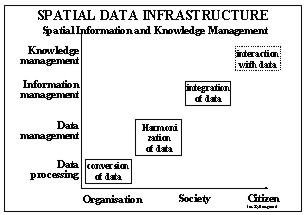
Information technology is indispensable but Spatial Data, Information and
Knowledge is a prerequisite.
Spatial Information and Knowledge Management will be in focus in the
years to come. Spatial Information Managers and responsible politicians will
become the main catalysts in the development, implementation and maintenance
of the necessary Spatial Data Infrastructures.
Guidance to the reader: Chapters 3-6 provide an introduction to
Sustainable Development, Spatial Data and Information, Spatial Data
Infrastructure and some related international events. Further details about
these topics are available in Appendix C. Chapter 7 contains the
recommendations. References to literature and links are in Appendix A. The
outcome of the Commission 3 Annual Meeting 2000 is in Appendix B.
2. Sustainable Development
Development is the managed process of change designed to improve the
conditions of members of a society. Sustainable Development implies that
this process should balance the exploitation of resources, the direction of
investments and the advancement of technology in a manner that affords the
same opportunity to future generations /C2/.
The sustainable exploitation of environmental resources requires
- Data to be available, up-to-date, reliable and usable indicating the
quality, quantity and spatial location of the various resources and the
size and spatial distribution of the population who depend on these
resources;
- The availability of tools to support the transformation of data into
understandable information for decision-makers, from national and
international levels to grassroot levels;
- Rethinking of both inter-organisational and intra-organisational
relations in order to improve the use of common data and the reuse of
data.
Almost all objects like roads, lakes, rivers, settlements, pollutions,
citizens, etc, in our environment have a reference to a specific location,
called a spatial reference. In the same way every change in or influence on
our environment has a reference to a specific location.
The spatial reference is a "main key" in the transformation of data into
information. Often the lack of availability, quality and coherence, means
that the standardization and accessibility of spatial data is a serious
hindrance for this transformation, and in that way a barrier for the
implementation of Sustainable Development.
3. Spatial Data and Spatial Information
Spatial Data is data with a direct or an indirect geographic reference to
the surface of the earth. A co-ordinate and an address are examples of a
direct reference whereas the relation between the discharge of polluted
water and the location of the property where the source of pollution is
situated could be an example of an indirect reference. Combining data from
one or more different sources creates information. More than 80% of all
information in society has a spatial reference. /C3/
Spatial Data and Information is an indispensable part of the basic
infrastructure of an individual country, as are roads, hospitals and
schools. Spatial Data and information is strategically important to
decision-makers at all levels. Like other infrastructure elements the
establishment and maintenance of data implies high costs and lengthy
implementation time.
Unlike other resources, Spatial Data does not suffer any wear and tear
from repeated use. Reusing of data increases the possibilities for improving
the quality of the content of data collections. The real benefit of
investments in Spatial Data increases dramatically with the multiple use of
data.
Provided that data are based on a common spatial reference system with
Geographic Information Systems (GIS) it becomes possible to integrate,
analyse, model and visualize spatial data from the different sources on the
local as well on the national and international level.
Management of Spatial Data, Information and knowledge is a key element in
the processes which lead to users of Spatial Data and Information having a
better overview of both simple and complex problems and which give users the
possibility to create comprehensible and thus acceptable solutions and/or
compromises. Consequently Spatial Information and Knowledge Management
becomes an important discipline in both developed and developing countries
and in countries in transition.
4. Spatial Data Infrastructure
Regardless of the stage of development, there are innumerable very
different applications for spatial information for instance:
- Transportation infrastructure in a region;
- Health-monitoring programmes;
- Cadastre and land management.
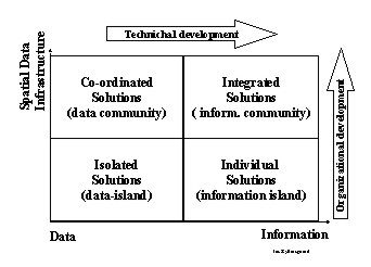
The variety of applications implies a need for co-operation between the
primary user (the owner of the data) and other possible users on standards,
common data models, object definitions, common, keys, availability,
copyright, prizing models, etc. There is a need for development and
implementation of a Spatial Data Infrastructure based on a holistic
approach comprising organisational, political and technical matters. /C4/
In 1994 the Federal Geographic Data Committee defined a National Spatial
Data Infrastructure (NSDI) as: the technology, policies, standards, and
human resources necessary to acquire, process, store, distribute, and
improve utilization of geo-spatial data /www.fgdc.gov/.
The information requirements for managing Sustainable Development require
datasets to be available locally, nationally, regionally as well as
globally. There is therefore a need to create a 'vertical information
highway' to allow transaction based information to be generated through
administrative activities at the local level, e.g. land registration, to be
aggregated through the local - national - regional - global levels. This
approach to recycling information through different levels of Spatial Data
Infrastructures will ensure that datasets are current and compatible.
The development and implementation of a Spatial Data Infrastructure for a
nation or a region is the prerequisite for a sustainable future where:
- Data collected and maintained by one administrative unit are available
for other users;
- Data from different sources can be combined in seamless models without
loss of information;
- Dissemination, modelling and visualization are based on international
standards.
5. FIG Involvement
The member associations behind FIG as well as the individual surveyors
are involved in activities being or becoming important for Sustainable
Development in the different regions of the world. Therefore FIG is
constantly engaged in the issue. /C5/
In 1999 the FIG Commission 7, in close cooperation with UN organisations
and the World Bank, held the workshop on "Land Tenure and Cadastral
Infrastructures for Sustainable Development" in Australia. The outcome
of the workshop, "The Bathurst Declaration on Land Administration for
Sustainable Development" /5/, is primarily devoted to issues relevant for
the administration of land. The declaration points out the need for Spatial
Data and Information, and the need for a land information infrastructure. A
land information infrastructure is a subset of a Spatial Data
Infrastructure.
In 2001 the FIG General Assembly adopted the proposal "FIG Agenda 21 -
Agenda for implementing the concept for Sustainable Development in the
activities of the International Federation of Surveyors and its member
associations" /6/. The main findings call attention to the fact that
promotion of Sustainable Development demands formulation of a Spatial Data
Infrastructure.
6. United Nations Activities Related to
Spatial Data
In 2001 the United Nations arranged two regional conferences addressing
topics related to spatial information /C6/.
The Seventh United Nations Regional Cartographic Conference for the
Americas was held in New York 22-26 January 2001 /7/ and /11/.
Spatial Data Infrastructure is mentioned in most of the 10 resolutions
adopted by the conference. Resolution no 7 is explicit about "Implementation
of National Spatial Data Infrastructures in the Americas". The conference
recommends:
- That the member states share experiences and address common needs and
interests within the Americas and with other regions of the world, through
the Permanent Committee on Spatial Data Infrastructure for the Americas
(established in the year 2000);
- That all countries of the Americas embrace the concept of NSDIs and
develop implementation strategies that support regional and global SDI
initiatives while meeting national objects.
The Second Meeting of the Committee on Development Information
(CODI-2) arranged by the United Nations Economic Commission for Africa
(UN-ECA) was held in Addis Ababa 4-7 September 2001. /8/
The Development Services Division of UN-ECA had prepared a position paper:
"The Future Orientation of Geoinformation Activities in Africa" /9/. The aim
of the paper was "To raise awareness of African governments on the
importance of geographic information…". The paper, which contains very
valuable information about and examples on topics related to Spatial
Information was endorsed by the meeting.
The Committee on Development Information recommends:
- That the member states give priority to the establishment of Spatial
Data Infrastructures;
- That mechanisms be immediately set in motion by African countries to
develop the national GI policy as an integral part of the National
Information and Communication Policies;
- That African countries should develop appropriate institutional, legal
and technical framework to integrate land administration and topographic
programmes within the context of a wider national strategy for Spatial
Data Infrastructure;
- That African countries should follow, with appropriate adaptions, the
model policy guidelines presented in ECA's position paper on Future of GI
activities in Africa;
- The establishment of a permanent committee on SDI's for Africa to
promote the coordinated establishment of SDIs in African countries and to
facilitate the establishment of a regional Spatial Data Infrastructure and
the African Regional Database;
- That regional SDIs should be established to meet the wish for regional
applications.
7. Recommendations
In the light of the recommendations from international and regional
conferences, workshops and task forces it was obvious to focus the outcome
of the Nairobi Conference on how to implement Spatial Data Infrastructure on
national and regional levels.
The recommendations are based on the different presentations, on the
results from the discussions in plenary and on experiences from former
Commission 3 activities /B/.
The recommendations are designed to provide a practical way forward to
create a National Spatial Data Infrastructure to support Sustainable
Development. In addition two FIG specific recommendations are formulated.
The recommendations on Spatial Data Infrastructure are split up in three
groups:
- The National Perspective;
- The Regional Perspective;
- The Global Perspective.
The three groups are divided in subgroup as follows:
- The National Perspective:
- National Organizations;
- National Policies, Strategies and Implementation;
- Legal Aspects;
- Capacity Building.
- The Regional Perspective:
- Regional Strategies and Activities;
- The Global Perspective:
- UN-ECA (www.uneca.org) and
African Countries;
- Technology Transfer - The Role of the Vendors;
The inter-relationship between the recommendations is shown in the figure
below.
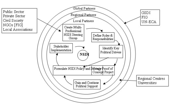
7.1. The National Perspective
7.1.1. National Organisations
- National Spatial Data Infrastructures (NSDIs) are underpinned by
effective partnerships and co-operation amongst a wide variety of
multi-disciplinary stakeholders in the public and private sectors and the
end user communities.
African countries are encouraged to form National NSDI Steering Groups
to formulate appropriate policy and institutional frameworks and
facilitate co-operation amongst the stakeholders. These National Steering
Groups should involve end user representation.
- Experiences from those countries that have embarked on the NSDI
process indicate that roles and responsibilities amongst the stakeholders
are clarified at an early stage.
African countries are recommended to clarify the lead role and the
responsibilities and roles amongst the other stakeholders - this will be
an initial activity of the National NSDI Steering Group.
- It is recognised that the rapid implementation of a NSDI must embrace
all available resources within a country. This will be best achieved
through partnerships between the public and private sectors.
Countries are encouraged to involve all sectors in implementing a NSDI
and ensure that appropriate business models are agreed to support these
partnerships at an early stage.
7.1.2. National Policies, Strategies
and Implementation
- It is recognised that every NSDI is different due to varying cultural,
social and economic contexts within each country. However, there are a
significant number of common elements that can be shared. Countries should
avoid re-inventing these common elements.
- It is recognised that complete policy and institutional frameworks do
not have to be in place before implementation of a NSDI can begin.
- It is recommended that a top down approach is combined with a
pragmatic bottom up approach. Short term bottom up projects will provide
valuable experience and through proof of benefits, convince further
funding of NSDI.
- It is recognised that a mature NSDI will be a complex solution
involving a large number of stakeholders and user groups. From experience
the most effective examples of NSDIs are those that have started with
clear short term objectives with corresponding simple solutions.
African countries are encouraged to design solutions that start with
realistic objectives and grow incrementally through political and market
needs.
- The success of a NSDI is dependent upon delivering products and
services that are accepted and desired by the end users, both within
Government and the private sector and citizens. This key objective will
only be achieved if the requirements are clearly understood.
African countries are encouraged to provide for end user needs and
ensure that appropriate products and services are provided.
- It is recognised that a key success factor of implementing a NSDI is
the management of information as an asset, as is the case with finance and
human resources.
Countries are encouraged to adopt information as an asset and manage it
appropriately, e.g. only capture data that is needed and can be
maintained.
- A NSDI requires a culture of data sharing to exist within a country.
Although data may be accessible for the common good, the organisations
providing data must in return receive a benefit for their contribution.
It is recommended that countries research the benefits associated with
data sharing to encourage wide participation.
- It is recommended that all countries establish unambiguous naming
conventions as a key component of their NSDI, following the guidelines
produced by the UNGEGN.
7.1.3. Legal Aspect
- Experience has shown that issues associated with national security,
data privacy and associated liability are potential show stoppers for NSDI
initiatives.
African countries are recommended to establish legal frameworks to
address these crucial legal issues as early as possible.
- Although there will be significant benefits for the data producers and
service providers, it is recognised that one of the main beneficiaries
should be the citizen.
African countries are encouraged to formulate appropriate legislation to
facilitate access to NSDI information and services by the citizen.
- It is recognised that the benefits of an NSDI are significantly
increased if it supports both niche and mass markets.
African countries are encouraged to ensure that the appropriate
legislative business frameworks are established to facilitate support of
mass markets.
7.1.4. Capacity Building
- National organisations, with the support of FIG and sister
organisations, are encouraged to organise regular Regional workshops to
raise awareness and knowledge sharing of Spatial Information Management
for Sustainable Development issues and solutions. This will be a
significant contribution to capacity building.
- African countries are encouraged to provide continuous capacity
building. If this is applied at the management level then this will be a
significant contribution to institutional building.
7. 2. The Regional Perspective
7.2.1. Regional Strategies and
Activities
- It is recommended that African countries establish regional
co-operation through joint initiatives that require regional information
management to support common interests. This will encourage knowledge
sharing and ensure common standards are implemented.
- It is recommended that existing regional centres of excellence in
Spatial Information review their current services in the context of the
NSDI agenda and ensure that appropriate services are provided to encourage
the establishment and support of NSDIs.
- Universities within Africa should be encouraged to work with the local
survey associations in the provision of Continuing Professional
Development.
7.3. The Global Perspective
7.3.1. UN-ECA and the African Countries
- The Permanent Committee for NSDI in the Pacific and South-East Asia
has been successful in promoting co-operation amongst the participating
nations.
The Commission On Developing Information (CODI) proposal for UN-ECA to
establish a Permanent Committee for NSDI in Africa is strongly supported.
- It is recommended that a Forum of Education and Training is
established as a sub-group under the Permanent Committee for NSDI in
Africa focussed on the sharing of Education and Training resources and
experiences.
- Land administration in Africa faces specific, but common elements,
e.g. variety of indigenous right, informal settlements, in relation to
statutory tenure arrangements.
It is recommended that African countries share knowledge and experiences
and develop guidelines within the framework of UN-ECA by the creation of a
Forum of Land Administration as a sub-group of the Permanent Committee for
NSDI for Africa.
- Land administration systems provide important foundation data for
NSDI.
The Forum of Land Administration is recommended to identify the
institutional and operational conditions for successful land
administration in Africa.
- As land tenure in Africa is varied, a good understanding of the
concepts of land tenure and its impact on registration is important.
The Forum of Land Administration is recommended to aim for a concerted
research effort on this subject.
- It is recognised that ISO (www.iso.org)
and the Open GIS Consortium
www.opengis.org
produce data and interoperability standards that should be adopted by
NSDI stakeholders.
It is recommended that UN-ECA produce best practice guidelines providing
NSDI implementors with practical advice on how to effectively implement
these essential standards.
7.3.2. Technology Transfer - The Role
of the Vendors
- It is recognised that the majority of NSDI implementors within Africa
have limited opportunity to be exposed to the technical options available
to build NSDI.
Vendors are encouraged to support a new approach to technology transfer
in Africa.
- It is recognised that many of the key infrastructure requirements of
NSDI, e.g. pervasive, effective telecommunications and Internet access,
are not widely available in Africa. This limits the applicability of
leading edge NSDI technical solutions in Africa.
Vendors are encouraged to understand the needs of African countries and
design and market appropriate technical solutions.
7. 4. The FIG Perspective
7.4.1. FIG Specific Recommendations
- There is a need for co-operation by FIG (www.fig.net)
Ad hoc Commission on construction economic and management with other
international and regional cost management associations, for research into
cost management and community based driven organisational models for low
cost housing and the publication of the results for dissemination.
- There is a need for FIG to establish a Cross Commission Working Group
to harmonise land management and planning issues with construction and
cost management of low cost housing delivery with holistic requirements
and within the framework of FIG Agenda 21.
/1/: Al Gore: The Digital Earth: Understanding our Planet in the 21st
Century. Given at the California Science Center, Los Angeles, California, on
January 31, 1998.
/2/: The Longman Dictionary Of The English Language. Harlow, UK. Longman.
/3/: Jes Ryttersgaard: Spatial Information Management Supporting Sustainable
Development, Proceedings from Commission 3, The FIG Congress in Brighton,
England. 1998.
/4/: Jes Ryttersgaard and Stig Enemark: From GIS to Geographic Information
Management, Organisational and Educational Impacts. GIS/LIS For Sustainable
Development - GIS/LIS For The Future.FIG Commission 3 Seminar, 28 - 30
October 1996, Copenhagen, Denmark.
/5/: The Bathurst Declaration on Land Administration for Sustainable
Development. FIG Publication No 21, December 99. /
www.fig.net
/
/6/: FIG AGENDA 21, FIG Publication No 23, February 2001. /
www.fig.net
/
/7/: Seventh United Nations Regional Cartographic Conference for the
Americas, New York, 22-26 January 2001. Report of the Conference
(E/CONF.93/3)
/8/: Report of the Sub-Committee on Geoinformation, Committe on Development
Information, United Nations Economic Commission for Africa, 2001. /
www.uneca.net
/
/9/: The Future Orientation on Geoinformation Activities in Africa, A
position Paper. Development Information Services Division (DISD), United
Nations Economic Commission for Africa, 2001. /
www.uneca.net
/
/10/: International Conference on Spatial Information for Sustainable
Development, Nairobi, Kenya, 2-5 October 2001. /
www.fig.net
/
/11/: Spatial Information Management in the 21st Century, Robert Foster,
Matt Higgins, Jes Ryttersgaard, FIG 2001 /
www.fig.net
/
- The SDI Cookbook, version 1.1 15 May 2001:
www.intl-interfaces.net/cookbook/WMS/
- Open GIS Consortium Web Mapping Testbed Public Page:
www.opengis.org/wmt/index.htm
- Open GIS Consortium Interoperability Program Page:
ip.opengis.org
- Web Map Server Interfaces Implementation Specification Revision 1.0.0:
www.opengis.org/techno/specs/00-028.pdf
Spatial Information Management
Experiences and Visions for the 21st Century
Outcome of the Commission 3 - Annual Meeting and Workshop
Athens, Greece, 4-7 October 2000
Experiences
- National Spatial Information Infrastructure (NSDI) is an Asset for all
Nations in general. It should be considered as a key part of wider
infrastructure assets such as roads, telecommunication networks etc.
- Establishing of a Spatial Information Infrastructure demands
co-operation/partnership between the public and the private sectors and
amongst the variety of professions involved.
- Given the complexity of existing institutional structures, one can
expect conflicts when seeking co-operation in NSDI strategy formulation
and implementation.
- NSDI can proceed even if a formal policy document [top down approach]
does not exist. It is possible to proceed with certain operational level
activities [bottom up approach] while the policy is being formulated.
These activities can themselves drive and encourage policy.
- Every NSDI will be different, depending on cultural needs, social
evolution, economic reality and national ambitions. The environmental
framework and the market demand will shape the most appropriate SDI.
- NSDI policy must be flexible to address rapidly changing needs and
wishes of the users and adapt to changing technologies.
- Varied applications and services through a project oriented approach
will bring reality to the NSDI (GSDI). An over emphasis on data
acquisition, without a market linked application, will not provide any
momentum for further development.
- The potential values and benefits have to be demonstrated through
large scale projects to encourage further investment.
- Currently, it is often difficult, or even impossible, for users to
sensibly combine data from different sources.
- It is essential that users are involved in defining and testing the
associated products and services.
- Visualisation, modelling and analysing activities will be the focus of
value added services in the years to come.
Visions
- Cadastral, topographic and thematic datasets should adopt the same
overarching philosophy and datamodel to achieve multi-purpose data
integration, both vertically and horizontally.
- To be able to integrate and share data we need to focus on research to
understand and resolve different semantics in data.
- To be able to offer the different users [institutional as well as
private] the full potential of spatial information independent of space
and time, the full range of spatial data, actual as well as historical,
should be made accessible and available
- Alternative possibilities for the presentation and interpretations of
spatial information, including integration of knowledge, should be
considered.
- The commercial and contractual frameworks for co-operation and the
associated business models will be key issues in the further development
of NSDI.
- To be able to adapt to the e-market rethinking of pricing, rights and
access to data is necessary.
C1. The History of and the Partners
behind the International Conference on Spatial Information for Sustainable
Development
The International Conference on Spatial Information for Sustainable
Development, held in Nairobi, Kenya 2-5 October 2001, was organised by the
Institution of Surveyors of Kenya, the International Federation of Surveyors
(FIG) and the UN-Habitat.
In June 1999 the United Nations Economic Commission of Africa (UN-ECA)
had its first meeting of the Committee on Development Information (CODI). A
resolution from the sub-commission on Geo-Informatics recommended FIG, ICA,
ISPRS and UN-ECA in co-operation to hold seminars in 2000-2001 in Anglophone
and in Francophone Africa.
In October 1999 FIG Commission 3, Spatial Information Management, decided
to fulfil the CODI-resolution by having its annual meeting and a
seminar/conference in an Anglophone African country in 2001.
The conference became a reality because of support and help from the main
sponsors United Nations Environmental Program (UNEP), GEOMAPS and
Institution of Quantity Surveyors of Kenya, the co-sponsors Metrocosmo
Valuers Ltd, University of Nairobi, Intergraph Mapping and GIS Solutions,
Swedesurvey AB and a number of companies and institutions who have
contributed in one way or another. In addition the United Nations Economic
Commission for Africa and United Nations Food and Agriculture Organization
were active participants.
C2. Sustainable Development
Development is the managed process of change designed to improve the
conditions of members of a society. Sustainable Development implies that
this process should balance the exploitation of resources, the direction of
investments and the advancement of technology in a manner that affords the
same opportunity to future generations.
|
The United Nations
defines a sustainable society as one which:
meets the need of the present without sacrificing the ability of future
generations to meet their own needs', and Sustainable Development is
'development that meets the needs of the present without compromising
the ability of future generations to meet their own needs
(Brundtland 1992, 87). |
The theme of the conference was strongly related to the international
community's efforts to advance the implementation of the Habitat Agenda
(paragraphs 76 and 114) as well as the implementation of important elements
of Chapters 7,10 and 40 of the Agenda 21.
|
Habitat Agenda: Paragraph 76 (Action)
To ensure an adequate supply of serviceable land, Governments at the
appropriate levels and in accordance with their legal framework should:
Develop and implement land information systems and practices for managing
land, including land value assessment, and seek to ensure that such
information is readily available;
Habitat Agenda: Paragraph 114 (Action)
To develop and support improved and integrated land management,
Governments at the appropriate levels, including local authorities, should:
Develop integrated land information and mapping systems.
|
|
United Nations Sustainable Development, Agenda 21
- Chapter 40
Information for Decision-Making
40.1. In Sustainable Development, everyone is a user and provider of
information considered in the broad sense. That includes data, information,
appropriately packaged experience and knowledge. The need for information
arises at all levels, from that of senior decision makers at the national
and international levels to the grass-roots and individual levels.
40.2. While considerable data already exist, …., more and different
types of data need to be collected, at the local, provincial, national and
international levels, indicating the status and trends of the planet's
ecosystem, natural resource, pollution and socio-economic variables.
The gap in the availability, quality, coherence, standardization and
accessibility of data between the developed and the developing world has
been increasing, seriously impairing the capacities of countries to make
informed decisions concerning environment and development.
40.3. There is a general lack of capacity, particularly in developing
countries, and in many areas at the international level, for the collection
and assessment of data, for their transformation into useful information and
for their dissemination.
40.5. …To develop or strengthen local, provincial, national and
international means of ensuring that planning for Sustainable Development in
all sectors is based on timely, reliable and usable information and to make
relevant information accessible in the form and at the time required to
facilitate its use.
40.9. Relevant international organizations should develop practical
recommendations for coordinated, harmonized collection and assessment of
data at the national and international levels. ………..
40.17. There already exists a wealth of data and information that
could be used for the management of Sustainable Development. Finding the
appropriate information at the required time and at the relevant scale of
aggregation is a difficult task.
40.18. Information within many countries is not adequately managed,
because of shortages of financial resources and trained manpower, lack of
awareness of the value and availability of such information and other
immediate or pressing problems, especially in developing countries. Even
where information is available, it may not be easily accessible, either
because of the lack of technology for effective access or because of
associated costs, especially for information held outside the country and
available commercially.
40.22… Mechanisms should be strengthened or
established for transforming scientific and socio-economic assessments into
information suitable for both planning and public information. Electronic
and non-electronic formats should be used. Establishment of standards and
methods for handling information
|
Planning and implementation of Sustainable Development means that
decision-makers on all levels in the public as well as the private sector
should be able to evaluate risks and consequences of the possible solutions
and scenarios. This demands the ability to access to all relevant
information and subsequently the possibility to transform the available data
into useful information. The relevant data and information need to be
up-to-date, reliable and usable.
Promotion of Sustainable Development demands overview, experience and
knowledge that can be related to events (what has happened and what
will happen?), those involved (who was in involved or who will be
affected?), time (when did it happen and when will it happen?) and a
location (where did it or will it happen?).
In general "events" and "those involved" can be linked directly or
indirectly to a specific geographic location. The location is the "main key"
to data and information that is a condition for planning, development,
implementation and administration of Sustainable Development.
C3. Spatial Data and Spatial Information
In the paper "The Digital Earth: Understanding our Planet in the 21st
Century", written by the former American Vice President Al Gore you can find
the following:
"A new wave of technological innovation is allowing us to capture, store,
process and display an unprecedented amount of information about our planet
and a wide variety of environmental and cultural phenomena. Much of this
information will be "geo-referenced" - that is, it will refer to some
specific place on the Earth's surface. The hard part of taking advantage of
this flood of geo-spatial information will be making sense of it, -turning
raw data into understandable information" /1/.
|
Within FIG normally the term
Spatial Data is used for "georeferenced data". Combining data creates
information. Spatial Information is information with a reference to a
specific location (coordinate, an address, a property number, a cadastral
number, etc)
|
With Geographic Information System (GIS) it becomes possible to
integrate, analyze, model and visualize spatial data from different sources
on the local as well as the national and international level, provided that
data from the different sources have common "keys". Spatial Data and
Information have the spatial component as the common key. With GIS it
becomes possible to create overview and knowledge in up to now unseen
combinations.
Spatial data is a resource on a par with employees, funds etc. Use of
spatial information opens up the possibility to increase efficiency in the
public and the private sector.
Spatial Data is an indispensable part of the basic infrastructure in the
individual country, in line with roads, hospitals, schools etc. Spatial Data
is strategically important to decision makers at all levels.
|
Infrastructure is the basic structures and
facilities necessary for a country or an organization to function
efficiently. An infrastructure has the following characteristics:
Users are aware that 'somebody' maintains the infrastructure, but do
not regard this maintainer as an owner. Users it to always be available,
even if there is a fee or other consideration for its use.
The delivery or provision of the service is
standardised to a large extent. As a result of the standardized delivery,
users take it for granted because of the ease of use. Infrastructures are
expensive to develop and maintain, and the returns from the investment are
usually long term. /2/
|
Management of Spatial Data and Information is a key element in the
processes which leads to users of Spatial Information having a better
overview of both simple and complex problems and which give users the
possibility to create comprehensible and thus acceptable solutions and/or
compromises.
|
Spatial Information Management is based on the
idea that data, people, software and hardware interact, and that it is
practicable to obtain synergy by co-ordinating changes and development.
The concept covers different disciplines such as capture, storing,
maintenance and upgrading of data and information, information technology,
organisational issues and spatial data infrastructure.
Spatial Information Management is a
discipline for the individual organisation, administration or enterprise,
the micro level, and for society in general, the macro level. On the micro
level there will be a technical approach whereas on the macro level
political and organisational issues will be highlighted. /3/
|
Spatial Information Management is a dynamic concept. It changes in line
with the technological possibilities and the political and organisational
developments in society in general.
Spatial Information Management is also about human resources and
organisational changes. Being involved in Spatial Information Management
means to be in the focal-point between man and technology.
Spatial Information Management becomes an important discipline in
both developed and developing countries and in countries in transition.
Spatial Information Management as well as Spatial Knowledge Management is a
growth field for surveyors.
C4. Spatial Data Infrastructure
Spatial Data or Information stored in traditional paper maps is static.
Each map sheet represents a snapshot of selected objects at a given time,
and "the owner" has an exclusive right to the map. In contrast a digital map
or better a collection of spatial and spatial related data is dynamic with
the time parameter as a part of the individual data collection.
In "the digital world" we have different owners of spatial data, many
different users and an unknown number of applications for Spatial
Information. The following are a few examples of some very different, areas
of application:
- Transportation infrastructure in a region;
- Health monitoring programmes;
- Socio-economic issues;
- Cadastre projects;
- Land management;
- Natural resource management;
- Monitoring of environmental issues;
- Environmental impact assessment;
- Conservation projects.
The variety of applications implies a need for co-operation between the
primary user and other possible users on standards, common data models,
object definitions, common identification, keys, availability, copyright,
prizing models, etc. There is a need for a well-documented Spatial Data
Infrastructure.
In the early 1990's much attention was focused on Geographic Information
Systems (GIS) as a basis for Land information Systems. Soon it became
obvious that the pure technical approach had to be replaced by a more
holistic approach comprising organisational, political and technical
matters. The concept of Spatial Data Infrastructure became a reality.
In 1990 the United States Federal Geographic Data Committee (FGDC) was
established to promote the coordinated use, sharing, and dissemination of
geospatial data on a national basis.
|
In 1994 FGDC defined
National Spatial Data Infrastructure (NSDI) as: the technology,
policies, standards, and human resources necessary to acquire,
process, store, distribute, and improve utilization of geo-spatial
data. / www.fgdc.gov / |
At the FIG Commission3 seminar in Copenhagen in October 1996 "GIS/LIS for
Sustainable Development, GIS/LIS and the future" it was expressed in the
following way:
"The design, establishment and continued extension of Land Information
Systems are rather to be seen as organisational and political matters than
purely technical. The point is to create organisational and technical
infrastructures which make it possible to establish simple, clear and
well-working data collections that at the same time can support the
individual organisation and also be placed at the disposal for the society
in general…. ". /4/
In 1997, at the second Global Spatial Data Infrastructure Conference, the
first definition of Global Spatial Data Infrastructure (GSDI) was adopted.
It was revised in May 2001.
|
The GSDI Steering Committee agrees to the
definition for the GSDI as follows:
"The Global Spatial Data Infrastructure
supports ready global access to geographic information. This is achieved
through the coordinated actions of nations and organizations that promote
awareness and implementation of complimentary policies, common standards and
effective mechanisms for the development and availability of interoperable
digital geographic data and technologies to support decision making at all
scales for multiple purposes. These actions encompass the policies,
organizational remits, data, technologies, standards, delivery mechanisms,
and financial and human resources necessary to ensure that those working at
the global and regional scale are not impeded in meeting their objectives"
/www.gsdi.org/
|
C5. FIG Involvement
The member associations behind FIG as well as the individual surveyors
are involved in activities that are or will become important for Sustainable
Development in the different regions of the world. Therefore FIG is
constantly engaged in the issue.
In 1999 the FIG Commission 7, in close cooperation with UN organisations
and the World Bank held the workshop on "Land Tenure and Cadastral
Infrastructures for Sustainable Development" in Australia. The outcome
of the workshop is documented and published in "the Bathurst Declaration on
Land Administration for Sustainable Development" /5/.
In 2001 the FIG General Assembly adopted the proposal "FIG Agenda 21 -
Agenda for implementing the concept for Sustainable Development in the
activities of the International Federation of Surveyors and its member
associations". /6/
The main findings call attention to the fact that promotion of
Sustainable Development depends on demands for the formulation of a Spatial
Data Infrastructure.
C5.1. The Bathurst Declaration
The Bathurst Workshop addressed the changing relationship of humankind to
land. The Workshop then considered the relationship of land with Sustainable
Development, and the consequent relationship of land tenure to land
administration.
The Bathurst Declaration is primarily devoted to issues relevant for
administration of land. The declaration calls attention to the need for
Spatial Data and Information, and the need for a land information
infrastructure.
A land information infrastructure is a subset of a Spatial Data
Infrastructure.
|
Quotations from the workshop findings:
… If relevant and good decisions are to be made by public authorities,
private resource users or community bodies, they must be based on sound
information about the land and environment in order to contribute to
Sustainable Development. …….
These ambitious goals will not be achieved unless there is a
commitment to designing and implementing effective land administration
infrastructures. These may be described as the organisations, standards,
processes, information and dissemination systems and technologies required
to support the allocation, transfer, dealing and use of land. ……
Information technology will play an increasingly important role both
in constructing the necessary infrastructure and in providing effective
citizen access to information. Finally, there must be total commitment to
the maintenance and upgrading of the land administration infrastructure. …….
and one quotation from the recommendations:
Encourage the flow of information relating
to land and property between different government agencies and between these
agencies and the public. Whilst access to data, its collection, custody and
updating should be facilitated at a local level, the overall land
information infrastructure should be recognised as belonging to a national
uniform service to promote sharing within and between nations.
|
C5.2. FIG Agenda 21
In the foreword to the publication "FIG Agenda 21" the President of FIG
Robert W. Foster makes the following statement:
"Dealing with surveying, planning and management of land and water
resources, laws and systems needed for access to land and security of
tenure, and with geographic information in all its aspects, the surveying
profession is deeply involved in issues of profound importance for
Sustainable Development …"
FIG Agenda 21 gives examples and directions on how surveyors can
contribute to implement and support Sustainable Development in all regions
of the world.
Chapter IV is dedicated to Spatial Information for Decision Making. After
having underlined the importance of data as a basis for decision making, the
attention is drawn to the fact that although data quite often exists, it is
difficult to access and, is not standardized etc. Finally it is pointed out
that the lack of infrastructure is a barrier for sharing, use and reuse of
data.
|
Quotations from FIG Agenda 21 Chapter 6:
Good decisions for Sustainable Development depend on access to
reliable and relevant information and to a very large extent on information
that is geographically referenced. The need for geographic information
arises at all levels of government, from senior decision-makers to the grass
roots and individual levels.
Considerable data exist, but access to data is often hampered by lack
of standardisation, coherence and adequate services for data retrieval,
including information about what data exist and where data are kept.
The rapid development of technologies and
methods in surveying and mapping, such as integrated geographic information
systems, remote sensing, satellite positioning systems and digital networks
for sharing and disseminating of data, provides a strong and important tool
for decision making for Sustainable Development. Accessible and relevant
geographic information will play an important role in planning, executing
and monitoring development. Developing countries have embarked on
implementing spatial infrastructures for the optimal sharing and use of
geographic data in digital form. However, the majority of developing
countries lack the capacity to utilise the emerging technologies and
methods.
|
C6. United Nations Activities related to Spatial Data
In 2001 the United Nations arranged two regional conferences addressing
topics related to spatial information.
- The Seventh United Nations Regional Cartographic Conference for the
Americas was held in New York 22-26 January 2001 /7/
- The second meeting of the Committee on Development Information
(CODI-2) arranged by the United Nations Economic Commission for Africa was
held in Addis Ababa 4-7 September 2001. /8/
The outcome of the Conferences is recommendations calling attention to
the need for Spatial Data Infrastructure.
C6.1. The Regional Cartographic
Conference for the Americas
At the opening of the conference the following was highlighted:
"The concept and realization of the value of Spatial Data
Infrastructure was increasing. There was increasing facilitation of access
to a wide range of data, and the challenge was how to harness the
capability. The barriers were not related to technology but, in order to
restructure and focus on standards, various national mapping programs
would be required…. In 2000, various governments in the Americas, in
collaboration, created a Permanent Committee on Spatial Data
Infrastructure of the Americas……"
Spatial Data Infrastructure is mentioned in most of the 10 resolutions
adopted by the conference. Resolution no 7 is about "Implementation of
National Spatial Data infrastructures in the Americas".
|
The conference recommends:
That the member states share experiences and address common needs and
interests within the Americas and with other regions of the world, through
the Permanent Committee on Spatial Data Infrastructure for the Americas;
That all countries of the Americas embrace
the concept of national spatial data infrastructures and develop
implementation strategies that support regional and global SDI initiatives
while meeting national objects.
|
C6.2. Meeting of the Committee on Development
Information
The Development Services Division of UN-ECA had prepared a position
paper: "The Future Orientation of Geoinformation Activities in Africa". The
aim of the paper was "to raise awareness of African governments on the
importance of geographic information."
|
The conclusion of the position paper is:
It was established early in the paper that the future orientation of
GIS does not lie in the technology itself, but in its use to process data to
support spatial decisions and services.
Experience in some African countries suggests that emphasis on the
technology might result in the acquisition of hardware, software and
peripherals with no clear plans on how to use them. Others might go a step
further and use the technology to digitise maps and simply automate map
productions, creating large digital databases, which would be locked away
for departmental use, with all the flaws of the present manual systems.
Following experience in other jurisdictions,
emphasis should be placed on data management and dissemination. The vision
is to ensure that spatial data permeates every aspect of society and that
they are available to people who need them, when they need them, and in a
form that they can use to make decisions with minimal pre-processing. Also
the collected data sets should be put to the maximum possible uses by
publicising their existence and making them easily available to the widest
possible audience. The most efficient and effective way to achieve these two
related objectives is to establish spatial data infrastructures, using GIS
technology to maintain and exploit the SDI. The future orientation of GIS in
Africa is therefore as a ubiquitous tool that is integrated into the SDI
concept, rather than as an end in itself. /9/
|
The paper, strongly recommended to all interested in Spatial Data and
Information, became endorsed by the meeting.
On the background of national reports, prepared contributions from
invited speakers and a seminar on Spatial Data Infrastructure the Committee
on Developing Information recommends:
- That the member states give priority to the establishment of SDI's;
- That regional SDI's should be established to meet the wish for
regional applications;
- The establishment of a permanent committee on SDI's for Africa
|
The Committee recommends on Spatial Data
Infrastructure (SDIs)
Member States give priority to establish their NSDIs with all the
necessary components (national standards, metadata, clearing house, national
database). The content of the core datasets should be defined by a
collective effort of all GI stakeholders in the country;
For regional applications, Regional Spatial Data Infrastructure (RSDI)
be established with an African Regional Database as a component, based on a
unified African Reference System;
A permanent committee on Spatial Data Infrastructure for Africa be
established to:
- promote the coordinated establishment of SDIs in African countries,
- facilitate the establishment of RSDI and the African Regional
Database.
The permanent committee should follow the model of the Permanent
Committees for the Americas (PC-IDEA) and for Asia and Pacific.
Member states to participate in the work of the proposed permanent
committee and in the work of appropriate technical committees of the
International Standards Organization, notably Technical Committee 211
(ISO/TC 211);
The Committee recommends on Policy:
Mechanisms be immediately set in motion by African countries to
develop the national GI policy as an integral part of the National
Information and Communication Policies;
African countries should develop appropriate institutional, legal and
technical framework to integrate land administration and topographic
programmes within the context of a wider national strategy for spatial data
infrastructure;
African countries should follow, properly adapted, the model policy
guidelines presented in ECA's position paper on Future of GI activities in
Africa;
Further investigation be done on the
regulatory conditions under which NMA's are eligible for competitive
valued-added production and on the concept of cost recovery in various
accounting and financial regime.
|
C7. FIG Commission 3 - Spatial Information Management
In 1998 the field of responsibility for Commission 3 was changed from
Land Information System and GIS to Spatial Information Management. To day
the term Spatial Information Management (or Geographic Information
Management) has been adopted by several involved in the traditional GIS
businesses.
The new field of responsibility found expression in the following "Terms
of reference":
- Management of land, property and hydrographic information and the
related processes, procedures and resources
- Spatial Data Infrastructure - data models, standards, availability and
legal aspects, management of spatial knowledge
- The impacts on organisational structure, business models, professional
practice and administration
- Management of Spatial Information supporting Sustainable Development.
Against the terms of reference the Commission formulated the following
mission statement:
"Towards a digital earth" - How to change raw data into understandable
information.
C7.1. Work Plan 1998-2002
Commission 3 works through the Working Groups and by bringing people
together. In 1998 three working groups were established:
- WG 3.1: Spatial Information Management: technical approaches
- WG 3.2: Spatial Data infrastructure
- WG 3.3: Facilitating Spatial Information and Knowledge Management for
decision support: through appropriate organisational, political, business
structure.
At working weeks, annual meetings and seminars the Commission offer
people from different countries the possibility: to share experiences, to
become members of a global network and to become friends.
The results of the Working Groups and the meetings are made available to
the professional and political community in the form of reports and
proceedings.
Information on the Commission and its activities and results is available
on the Commission homepage on
http://fig3.boku.at.
|


