News
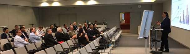
FIG Working Week 2025 - FIG Asia Pacific Capacity
Development Network report

The Network worked collaboratively with FIG Commissions, Task
Forces, and the Pacific Geospatial Survey Council (PGSC) to
organised 6 technical sessions and 2 Talanoa meetings for the 3-day
technical program
FIG Regional Conference 2024 will be held in Kathmandu, Nepal
14-16 November, 2024, Kathmandu, Nepal
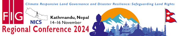
Read more here
FIG Asia Pacific Capacity Development Network Report FIG
Working Week 2023
The network held several meetings during FIG Working Week 2023,
28 May - 1 june 2023 in Orlando, Florida and was involved in
sessions in the technical programme.
FIG AP-CDN at FIG Working Week 2020
The Working Week 2020 was cancelled due to the COVID-19 outbreak.
FIG AP-CDN had planned two sessions during the Working Week. The Asia
Pacific Capacity Development Network, in collaboration with the UN
Sub-Committee on Geodesy - Education Training & Capacity Building, and the
UN Global Geospatial Information Management Asia Pacific Geodetic Reference
Frame WG, had invited delegates to provide their feedback and views on the
status of workings and future initiatives relating to geodetic capacity
development.
During the conference days a range of articles highlighting the
hot-topics, the ground breaking research, and the hidden gems in the
proceedings was published.
SEASC 2019 Darwin Declaration
15-18 August 2019, Drawin, Australia
Collaboration, Communication and Capacity Building.
Applications of Global Navigation Satellite Systems Workshop
Suva - Fiji, 24-28 June 2019
FIG Asia Pacific Capacity Development Network (AP CDN) and
Commission 5 – Position and Measurement members, along with
representatives from sister organisations actively
participated in the “Workshop on the Applications of Global
Navigation Satellite Systems”. FIG AP CDN convened two sessions,
focusing on the why, how and what of organisational planning for
the development of GNSS CORS infrastructure capability and
geodetic datum modernisation.
FIG AP-CDN at FIG Working Week 2019
The network held several meetings during the FIG Working Week
in Hanoi, Vietnam 22-26 April 2019 and was involved in sessions
in the technical programme.
United Nations World Geospatial Information Congress -
UNWGIC
19-23 November 2019, Deqing, China

Rob Sarib represented the FIG Asia Pacific Capacity
Development Network (AP CDN) at the UNWGIC congress. The
highlight session for FIG APCDN was “Operationalizing the UN
Integrated Geospatial Information Framework” . FIG APCDN was
also represented at the UN GGIM Subcommittee on Geodesy (UN
SCoG).
Report from the Reference Frame in Practice Seminar -
Operational Aspects of GNSS CORS
18-20 September 2018, Suva, Fiji
The FIG Asia Pacific Capacity Development Network (AP CDN)
convened another seminar of the Reference Frame in Practice
series in Suva, Fiji 18-20 September 2018.
The theme and objectives of the seminar was to provide
perspectives and case studies on technical matters relating to
the “Operational Aspects of GNSS CORS” infrastructure.
Presenters also delivered content on the - “what, why and how”
to build a sustainable and modernised geodetic reference frame
and datum; challenges faced in the Pacific in relation to
geospatial information management and data sharing; legal,
policy, and codes of practice (including standards); and the
issues pertaining to developing the capacity of surveyors in the
discipline of geodetic surveying.
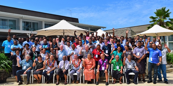
Group photo
References Frame in Practice Seminar - Operational
Aspects of GNSS CORS
18-20 September 2018, Suva, Fiji
In conjunction with FIG Asia Pacific Capacity Development
Network partners namely the Fijian Government - Ministry of
Lands and Mineral Resources, Pacific Geospatial and Surveying
Council (PGSC), the UN GGIM AP, FIG Commission 5, and the
Pacific Geospatial & Surveying Partnership Desk – Pacific
Community, a Reference Frame in Practice Seminar on Operational
GNSS CORS will be held in Suva, Fiji 18-20 September 2018. The
objectives of this event are to provide technical advice on the
operational aspects of GNSS CORS infrastructure, to build a
sustainable and modernised geodetic reference frame and datum,
and also develop the capacity of surveyors in the discipline of
geodetic surveying. Presently there will be over 20
presentations comprising of local and international speakers,
with almost 100 delegates registered! FIG and development
partners wish to thank Lecia Geosystems for their support.
FIG Asia Pacific Capacity Development Network Report from the Congress
7 May 2018, Istanbul, Turkey
As the FIG Asia Pacific Capacity Development Network Chair a special
forum on “Asia Pacific Capacity Development Network” was convened, and
an invitation to participate in the United Nations Geodesy Sub-Committee
on “Education Training and Capacity Building in Geodesy” forum as the
FIG nominee was accepted . As the titles suggest both forums were
intrinsically linked with respect to geodetic capacity development
activities and the plans for the future. The total number of the
delegates at these forums was almost 60.
Read the
report...
Regional Challenges, Benefits and Opportunities of
Exchanging Geodetic Data
17-19 October 2017, Kumamoto Prefecture, Japan
The Regional Committee of United Nations Global Geospatial
Information Management for Asia and the Pacific (UN-GGIM-AP), in
collaboration with the Government of Japan, through the
Geospatial Information Authority of Japan (GSI) has organised
the Sixth Plenary Meeting of UN-GGIM-AP in Kumamoto Prefecture,
Japan, from 16-19 October 2017.
As a result of workshop discussions at the reference frame in
practice seminar held in Kuala Lumpur, Malaysia - October 2016 a
matrix of the regional geodetic (and geospatial) challenges, and
strategies to mitigate problems was developed by the
participating member states of Asia and the Pacific region.
Geospatial Information Authority of Japan (GSI), UN Global
Geospatial Information Management for Asia and the Pacific (UN
GGIM-AP) Work Group (WG) 1 Geodetic Reference Frames, and the
FIG Asia Pacific Capacity Development Network convened a meeting
for Asia Pacific member states on “Regional Challenges, Benefits
and Opportunities of Exchanging Geodetic Data”. This forum was
held prior to the UN-GGIM-AP Plenary Meeting on the 16 October
2017 at the Kumamoto City International Centre, Kumamoto
Prefecture, Japan. All member states of Asia and the Pacific
were invited to participate, and in response there were 44
delegates from 14 countries. Following this, there were 9
invited presentations to stimulate meeting discussions on the
related themes.
One day meeting on “Regional Challenges, Benefits and
Opportunities of Exchanging Geodetic Data”
The Geospatial Information Authority of Japan (GSI) ,
FIG Asia Pacific Capacity Development Network, and the UN
Global Geospatial Information Management for Asia and the
Pacific Working Group 1 are jointly hosting a one day meeting on
“Regional Challenges, Benefits and Opportunities of Exchanging
Geodetic Data” on 16 October 2017, at the Kumamoto City
International Centre in Kumamoto Prefecture, Japan.
This meeting with United Nation Asia Pacific country member
delegates will workshop -
- the social, technical, environmental and economic
benefits and opportunities of accessing and sharing geodetic
data;
- open geodetic data and access policies;
- geodetic data / licencing agreements; in particular the
UN-GGIM Compendium on Licensing Geospatial Information;
- the state of play of geodetic data sharing in Asia;
- geodetic data that should be shared and accessible; and
- examine solutions to challenges, impediments and the way
forward.
For more information about this meeting please navigate to -
https://gsi-intl.github.io/ggim-ap-kumamoto/
Please note this meeting will be convened prior to the UN
GGIM AP Plenary Meeting 17-19th October 2017 -
http://www.un-ggim-ap.org/meetings/pm/6th/201707/t20170704_389286.shtml
Reference Frame in Practice Seminar
29-30 July 2017, Kobe, Japan
The Reference Frames in Practice (RFIP) series has been in
operation since May 2012 and this year’s seminar was convened in
Kobe (Japan) on 29-30 July 2017. The seminar venue was the
Kobe Chamber of Commerce - Port Island, and was hosted by GSI -
Geospatial Information Authority of Japan. A special
thanks to Mr. Basara Miyahara and his team at GSI for their
great hospitality.
Like previous seminars this RFIP was well attended. It
attracted 68 delegates from 19 different countries. From a
program perspective, there were 21 quality presentations which
included 4 presentations from the event sponsors who provided a
manufacturers perspective on the issues and challenges relating
to geodetic reference frames.
The seminar’s objective was to provide fundamental geodetic
reference frame background, concepts and examine the associated
data and analysis techniques, each with a focus on practical
implementation and application.
Meeting during FIG Working Week in Helsinki, Finland
There were about 25 participants involved in the FIG Asia
Pacific Capacity Development Network (AP CDN) “breakfast”
meeting. The purpose of this meeting was to discover and share
information on FIG activities that are occurring in Asia and the
Pacific region, and how we can collaborate to achieve our work
plan objectives. At the meeting participants were encouraged to
voice their opinions on the capacity development challenges
being faced by our industry and how FIG can assist to address
these challenges.
Skills for the future
Article in GeoConnexion March 2017 written by Rob Sarib,
Chair of FIG Asia Pacific Capacity Development Network
Surveyors will need to develop and refine new skills if they
are to adapt to Future trends. Rob Sarib explains what FIG
believes modern surveyors need to know and what it’s doing to
help them in Asia and the Pacific regions
TECHNICAL SEMINAR ON REFERENCE FRAME IN PRACTICE
29-30 July 2017, Kobe - Japan

This seminar will be of benefit to operational geodesists or
surveyors who are dealing with reference frame issues and
crustal deformation, either in a government or commercial
environment. It is also open to academics or postgraduate
students in a surveying or related discipline.
More information on this special event
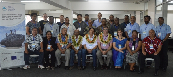
FIG Asia Pacific Capacity Development Network Report on
Activities in the Pacific Region – November / December 2016
Regional Capacity Network Meeting, 17-19 October 2016 –
Kuala Lumpur, Malaysia
The Regional Capacity Network Meeting – Asia/Pacific
Region was held in conjunction with the UN-GGIM-AP meeting
17-19 October 2016 in Kuala Lumpur, Malaysia.
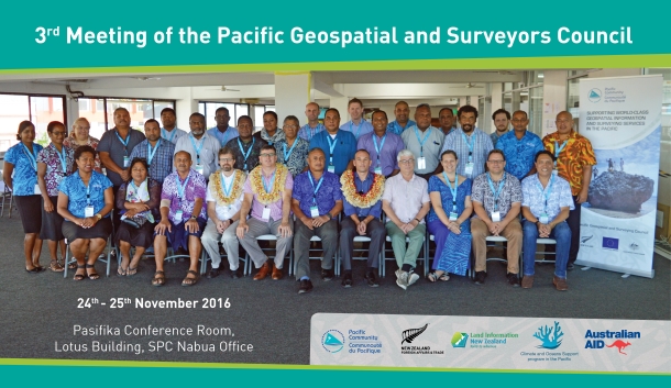
Pacific Geospatial Survey Council Meeting, 24-25 November
2016, Suva Fiji
Members of the Asia Pacific FIG Capacity Development Network
will be meeting with the Pacific Geospatial and Surveying
Council (PGSC) in Suva Fiji to finalise their Strategic Plan.
Network members from the Pacific Community Geoscience Division,
Geoscience Australia, UN GGIM AP WG1, Land Information New
Zealand, Mikael Lilje and Rob Sarib will also be participating
in a Vertical Reference Surface workshop on the 26 November
2016, and the GIS / RS Users Conference thereafter.
Pacific Geospatial and Surveying Council Meeting and GIS /
RS User Conference
November 2015 - Suva, Fiji
Global Geodetic Reference Frame for Sustainable Development
(GGRF) resolution adopted by the United Nations General Assembly
February 2015
In February 2015 the UN General Assembly adopted the
resolution “A Global Geodetic Reference Frame for Sustainable
Development” – the first resolution recognizing the importance
of a globally-coordinated approach to geodesy.
Geodesy plays an increasing role in people’s lives, from
finding directions using a smart phone to alleviating poverty.
Because the Earth is in constant motion, an acccurate point
of reference is needed for making measurements. Geodesy provides
a very accurate and stable coordinate reference frame for the
whole planet: A Global Geodetic Reference Frame. "The extent
and value to nations and the considerably increased economic
benefit of implementing the Global Geodetic Reference Frame will
be highlighted, alongside its role in underpinning the
Sustainable Development Agenda". Dr. Vanessa
Lawrence CB
http://www.unggrf.org/
|