FIG PUBLICATION NO. 57
Report on the Economic Benefits
of Hydrography
FIG Commission 4
Working Group 4.4 – Capacity Building and the Economic Benefits of Hydrography

Contents
Foreword
Andrew Leyzack, Canada
Introduction
Gordon Johnston, United Kingdom
Abstracts
Articles (as .pdf files)
Economic Impact of Hydrographic Surveys
Brian Douglas Connon, United States of America and Rod Nairn, Australia
The Economic Benefits of Hydrography and Ocean
Mapping
Gordon Johnston, United Kingdom
The Value of Hydrographic Information and its
Influence
Hugo M Gorziglia, IHO
The Cost-benefit of Charting Cameroon Waters
Cyril Mbeau Ache, Cameroon and Victor Abbott, United Kingdom
Methods to Assess the Financial Value of the
Sea Parcel and the Ecnomic of the Coastal and Marine Area within a Marine
Cadastre Framework
Johanes P. Tamtomo, Indonesia
Assessment and Future Prospects for Hydrography
in Western and Central Africa; Maritime Safety and Coastal Global Development
Dominique Baggio, France
Economic Benefits of Hydrography in the
Canadian Arctic – A Case Study
Andrew Leyzack, Canada
Why a National Hydrographic Service?
Prepared by Hugo Gorziglia, IHO
Presented by Gordon Johnston, United Kingdom
Papua New Guinea Hydrographic Service (PNG HS)
and the Future – Papua New Guinea Hydrographic Service, an ant with the giants
J. Kaunda, Papua New Guinea
Economic Benefit of Hydrography: Land
Reclamation in Bayelsa State – A Case Study of Saipem Camp
Angela Kesiena Etuonovbe, Nigeria
Restructuring of a National Hydrographic S
ervice – Croatian-Norwegian Hydrographic Information Project (CRONO HIP)
Egil Aarstad, Norway
Marine Geospatial Software: Generating Economic
Benefits from Hydrographic Data and Calculation of Maritime Boundaries
Serge Levesque and Alexis Cardenas, Canada
The Economic Impact of Appropriate Education in
Hydrography
David Dodd, Canada, Gordon Johnston, United Kingdom and Andrew Hoggarth, Canada
New Developments for the Professional Education
in Hydrography at HafenCity University Hamburg (HCU)
Peter Andree, Volker Böder, Peter Bruns, Delf Egge and Harald Sternberg, Germany
Orders for printed copies (this publication
is available only as a .pdf file).
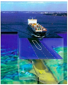
Hydrography involves the surveying and mapping of rivers, lakes and oceans
which gives us information about what the seafloor and movement of water above
that seafloor looks like. Hydrographic information is typically published in the
form of nautical charts and sailing directions both in hardcopy and digital
form. These nautical publications are critical for providing mariners with the
information they need to navigate ships safely and efficiently. Used in
conjunction with meteorological information, nautical publications provide a
basis for decisions on where and when a ship can be taken. High resolution
hydrographic information in the form of seabed imagery provides a basis for
engineering decisions on matters such as where to locate a sub-sea pipeline or
communications cable.
Much like towns and cities which have grown because of their close proximity
to railroads, superhighways and airports, access to navigable waters has
provided the earliest cornerstone for discovery and economic development the
world over. But what makes waters navigable? Fundamentally it is knowledge of
water depth, hazards, tides and currents that enables navigation. Hydrographic
information is of course the basis for this knowledge however it may be
communicated. What makes waters navigable also makes waters safe and thus
ensures the preservation of Safety Of Life at sea (SOLAS), the “sea room” to run
out a storm or to find an alternate ice free course to steer are all supported
by sound hydrographic information.
Bringing goods to and from market by sea and access to fisheries, sources of
energy and other natural resources at sea depends on sound hydrographic
information. When “just-in-time” service is not so critical, the economic
efficiencies and reduced carbon footprint associated with marine transportation
can outweigh all other modes of transportation. Frontier exploration and
development, harvesting and extraction, transportation, national sovereignty and
defence, all constructs supporting economic development are enabled by
hydrographic information. Access to and an understanding of land, including
submerged lands, is essential to claiming, developing and realising economic
sustainability. Surveyors have always played a role in supporting land tenure
and development and thus provide an essential connection between surveys,
mapping (charting) and the economy.
The International Federation of Surveyors (FIG), through the efforts of the
Commission 4 workgroup 4.4 on Capacity Building and the Economic Benefits of
Hydrography, has sought to bring awareness and promote the role of hydrography
as an essential investment in economic development. This publication provides a
snapshot of the workgroup’s efforts from various conferences and symposia to
stimulate thought and exchange ideas in this regard.
I would like to thank our working group chair, Mr. Gordon Johnston, the
authors who have contributed to this working group through various FIG Working
Weeks and Regional Meetings and those authors whose work has been selected for
this publication.
Andrew Leyzack, C.L.S.
Chair FIG Commission 4, 2007–2010
This publication aims to fulfil the objective of FIG Commission 4’s Working
Group 4.4, to develop an awareness of hydrographic surveying and raise its
profile in terms of how it can benefit society, cultures and developing states.
In the process of developing the project, the Work Group identified a general
lack of information and research to support the case for Hydrography across
different uses, businesses and interests. Additionally, the FIG Costa Rica
Declaration on Pro-Poor Coastal Zone Management (FIG Publication no. 43, 2008)
has developed the interest and the importance of the coastal zone and its
associated marine areas.
Consequently Work Group 4.4 has developed this document as a compilation of
papers, case studies and supporting articles to illustrate the tangible benefits
of hydrography and the potential economic benefits that may be derived from
developing and maintaining an appropriate hydrographic capacity.
This publication covers three different areas concerning the provision of
Hydrographic survey capability.
The first 3 papers relate to institutional and national Hydrographic services
and how these can generate a basis for developing and generating good economic
conditions. The papers outline the inherent value of Hydrographic surveys and
illustrate the context of Hydrography in terms of potential stakeholder benefits
and how Hydrographic information can have a positive influence.
The second series of articles provides a number of case studies from around
the globe that serve to illustrate how Hydrography has been able to provide a
basis for generating economic growth and benefits.
The final section of three papers concentrates on the development of the
personnel to establish a sustainable Hydrographic capacity. The papers provide
example experiences of achieving recognition at the International Standard level
and combining with industry to create cost efficient and effective training
solutions in the work place.
Background to the Working Group
As part of its 2007–2010 workplan, Commission 4 created Working Group 4.4
further to the XXIII FIG Congress in 2006 as it was identified that there is a
real lack of up-to-date material on the applications and uses of Hydrographic
data and products. In particular, information on how these products can support
the development of economic growth was missing and the Working Group sought to
increase the profile of Hydrographic Surveying at a strategic level. Since its
inception, the Working group has produced a number of cutting edge articles,
presentations and papers to further the subject and to raise awareness.
Technical sessions at the FIG working weeks, regional conferences and congress
meetings have generated interest, debate and further knowledge culminating in
this publication. The following table outlines various meetings and technical
sessions whereby over 20 papers and articles have been generated to provide a
rich source of information on capacity building and the economic benefits of
hydrography:
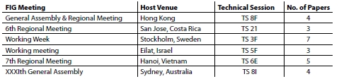
Table 1: FIG Meetings.
This report includes a selection of work to underscore just how Hydrography
can generate benefits for the wider community. The following table lists the
articles, papers and authors who have contributed to this Working Group
publication:
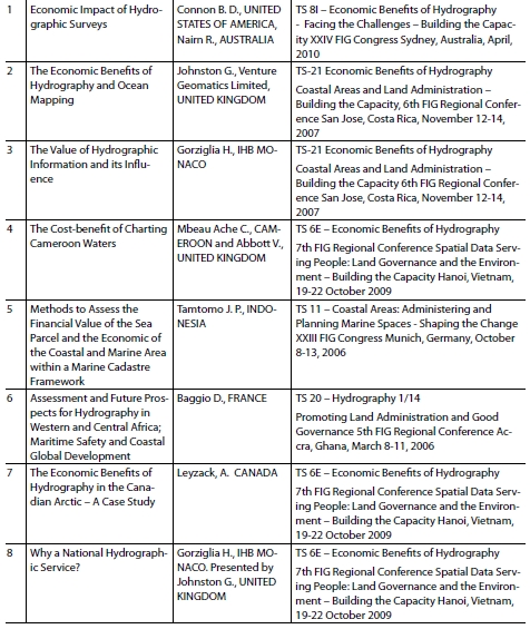
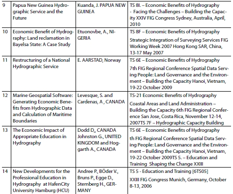
Table 2: Presentations on Capacity Building and the Economic Benefits of
Hydrography.
The papers listed in table 2 present case studies and examples of the
economic benefits of Hydrography. These can be found in the FIG Surveyor’s
Reference Library (http://www.fig.net/srl/),
and may be accessed directly via the hyperlink provided with the outline for
each in technical summary section of this document.
Conclusion
This has proven to be a very interesting initiative as the links between
Hydrographic services and products would appear to have a logical sequence and
relationship step. However the direct nature of the benefits has not been so
easily described. What has become apparent is the wide range of locations and
countries where the practice of Hydrography is having positive benefits.
In developing this document, Working Group 4.4 has gathered together a group
of articles and papers to illustrate the potential benefits of hydrographic
surveys and the products they create.
Early in the 1990’s both Canada and Australia undertook reviews of the
contribution made by their Hydrographic Services. They offered a very positive
situation in terms of the benefits at a national level; however these studies
failed to put precise monetary figures on the value gained from a specific level
of investment. More recent papers and articles promoting Hydrography, as well as
the UN conventions mandating hydrographic services, have also provided general
support but still some links are missing in the value chain from investment of
resources to the benefits to the wide array of potential stakeholders. This
document aims to rectify this shortcoming and provides a useful resource that
connects Hydrographic services with their ultimate benefits both in direct and
indirect terms.
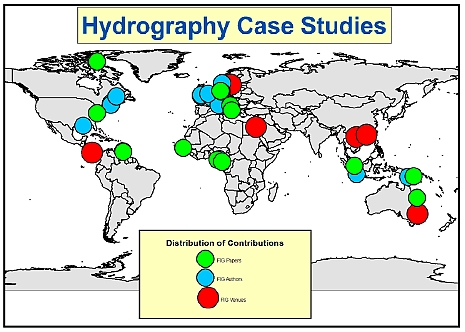
Figure 1: The world map illustrates the distribution of the case studies
and the venues where the Working Group Technical Sessions took place between
2007 and 2010.
As can be seen the FIG venues (Red circles) have played host to a truly
globally distributed set of Case Studies (represented by the Green circles)
presented by the authors (Blue circles) also representing a wide distribution.
The first few papers have outlined the general concept of Hydrographic
services and their benefits at a national level. The International Hydrographic
Organisation (IHO) maintains key links to international bodies and governments
and has a key objective to increase hydrographic capacity globally. FIG also
supports the development of communities and a number of the case studies in this
compilation illustrate the very real and direct benefit that hydrography can
bring to the local community, whether they are in the high arctic or in an
equatorial region.
The evaluation of the costs and then the potential benefits require a
systematic approach to avoid the statement “that there is a clear and positive
benefit gained from good hydrographic survey services” simply becoming a cliché.
Several papers address this technical element. Some recent studies such as the
review of the recent national survey by Ireland have provided some very useful
information and the papers by Ache & Abbott and Tamtomo provide useful
mechanisms to assess the value and benefits.
Having access to resources is one thing but there is also a need to ensure
that there are suitable people with appropriate competencies and qualifications.
The papers at the end of this compilation have been selected to provide an
insight to the varied ways to build capacity, generate and sustain a skilled
workforce. The Standards of Competence for Hydrographic Surveyors and Nautical
Cartographers, as maintained by the FIG/IHO/ICA International Board, as well as
the growing links between educational establishments, training facilities and
industry are of great benefit to Hydrographic Practice. Consequently investment
in Hydrographic training will benefit Hydrography which in turn will benefit the
wider community.
As this compilation highlights only a selection of the papers, presentations
and articles generated over the last 4 years, the remainder can be found through
the FIG website either in the Surveyors Reference Library section or in the
Proceedings of the various meetings and events. The Economic Benefits of
Hydrography have been described and clarified throughout the term of this
working group and it is apparent that the benefits from Hydrography are huge
compared to the investment where returns have been assessed as generally
exceeding a ratio of 5 to 1 over costs. However it should be recognized that
this figure was arrived at by considering all the stakeholders available to use
and adopt the services and products.
So for prospective government departments, expanding hydrographic offices,
services and other potential stakeholders there are benefits that outweigh the
investments and this must surely be of interest, certainly good news for the
profession, the end users of nautical publications and other Hydrographic
products , maritime communities and those who dwell within the world’s coastal
zones.
Gordon Johnston
Chair FIG Working Group 4.4, 2007–2010
Article 1: Economic Impact of Hydrographic
Surveys
Connon, USA, Nairn, Australia)
Key words: Hydrography, economics, bathymetry, coastal zone
management, hazard mitigation.
This paper discusses the inherent value of hydrographic services and
bathymetric surveys beyond the obvious benefit of improved nautical charts.
These direct and indirect benefits are not traditionally recognized for their
economic value to coastal States as they are difficult to quantify. Also their
actual value is somewhat dependent on the specific economic, recreational, and
defence activities of each coastal State. Convincing governments to invest in
hydrography and bathymetry can be difficult. However even without quantitative
analysis, there is strong logical and qualitative argument that recognizes the
critical value of hydrographic services as an essential element of national
infrastructure and a critical enabler of other maritime activities. Thus,
providing government with information detailing the second and third order
benefits of bathymetric surveys and hydrographic services may further influence
investment in these essential enablers of economic growth.
Article 2: The Economic Benefits of
Hydrography and Ocean Mapping
Johnston, UK
Key words: Hydrography, economics, bathymetry
To generate discussion around the need and justification for the development
and sustained use of hydrographic services to support and expand a national,
regional or local economy, this paper sets out to examine the current status of
hydrography in several areas in relation to a number of disciplines and user
groups. The use and benefit form Hydrographic data and products for stakeholders
are often promoted however there appear to be few direct and tangible outcomes
rather than simply vague links and indirect consequences. This paper aims to
offer a summary of some example assessments. For the increasingly competitive
market place of the global economy, coupled with a consumer group of increasing
knowledge and awareness of environmental issues the baseline and framework for
many activities relies upon good quality, reliable and objective data sets. The
paper offers some thoughts on how modern Hydrographic data and products as well
as the Hydrographic community could influence and aid in the strategic
development of areas and regions by working with the various stake holders.
Article 3: The Value of Hydrographic
Information and its Influence
Gorziglia, Monaco
Key words: capacity building, cartography, coastal zone management,
engineering survey, hydrography, marine cadastre, real estate development, risk
management.
The International Hydrographic Organization (IHO) and its objectives of
aiming at improving hydrographic capabilities worldwide are introduced in this
paper. Hydrographic development contributes to safety of life at sea and the
protection of the marine environment, while also contributes to sustainable
development. Highlights the importance of capacity building and invites
countries in the region to consider joint work with the Meso American and
Caribbean Hydrographic Commission, the regional structure of the IHO. The
definition of hydrography and nautical chart and nautical publications is
provided to fix the scope of the paper, including some economic characteristics
of these products. The paper makes to these products and identifies some
elements of main value. These elements are also cross-referenced with several
other different activities for which such information is required. The influence
of hydrographic information has in the decision making process of different
activities of national importance is described and some conclusions are offered
as invitation for further consideration.
Article 4: The Cost-benefit of Charting
Cameroon Waters
Ache, Cameroon, Abbott, UK
Key words: Hydrography, charting, cost-benefit analysis, Cameroon
The aim of the investigation was to examine the cost benefit to Cameroon of
charting her navigational waters. This paper concentrates on examining the
economic benefit of maritime trade in Cameroon and the potential economic
consequences that result from poorly updated nautical charts. A cost benefit
ratio was determined. The paper addresses:
- International and national trading activities
- The cost of surveying and charting activities
- The relationship between commercial, insurance and environmental costs.
The initial investigation compares Cameroon with other developing states.
From a description of the waters and trade in Cameroon, the paper addresses
resources in terms of ports, fishing, hydrocarbons and environmentally sensitive
areas. It describes the role of navigational charts and its contribution to the
growth of a state’s economy. In order to determine the benefit of charting
Cameroon Waters this paper provides a general assessment of the economic value
and importance of shipping operations out of the three major ports in Cameroon,
including fishery landings and foreign commerce. The estimated cost associated
with implementing a hydrographic programme for Cameroon is examined and a cost-
benefit ratio of 1:8 determined. Most coastal countries in the developing world
especially on the West coast of Africa are still to appreciate the relationship
and importance of hydrographic surveying to their economies. It is hoped that
this paper will benefit countries in transition to understand this relationship
and embrace the importance of implementing hydrographic programmes in their
countries and charting their own waters.
L'objectif de l'enquête était d'examiner les coûts-avantages pour le Cameroun
de tracer ses eaux à la navigation. Le document se concentre sur l'examen des
retombées économiques du commerce maritime au Cameroun et les conséquences
économiques potentielles qui résultent d'une mauvaise mise à jour des cartes
marines. Un ratio coût-bénéfice a été déterminé. Ce document examine:
- Les activités commerciales internationaux et nationales
- Le coût des activités de l'arpentage et de cartographie
- La relation entre les coûts commerciales, l'assurance et les coûts
environnementaux.
L'enquête initiale compare le Cameroun avec d'autres États en développement.
A partir d'une description des eaux et du commerce au Cameroun, le document
traite des ressources en termes de ports, pêche, hydrocarbures et les zones
écologiquement sensibles. Il décrit le rôle des cartes de navigation et sa
contribution à la croissance de l'économie d'un État. Afin de déterminer
l'avantage de la cartographie des eaux au Cameroun, ce document présente une
évaluation générale de la valeur économique et l'importance des opérations de
transport maritime sur les trois grands ports au Cameroun, y compris les
débarquements de la pêche et le commerce extérieur. Le coût estimatif associé à
la mise en œuvre d'un programme hydrographique pour le Cameroun est examinée et
un ratio coûts-avantages de 1:8 déterminée. La plupart des pays côtiers du monde
en développement en particulier sur la côte occidentale d'Afrique sont toujours
à apprécier la relation et l'importance des levés hydrographiques pour leur
économie. Il est à espérer que ce document sera bénéfique pour les pays en
transition de comprendre cette relation et d'embrasser l'importance de la mise
en œuvre des programmes dans leur pays d'hydrographie et de cartographie de
leurs propres eaux.
Article 5: Methods to Assess the Financial
Value of the Sea Parcel and the Economic of the Coastal and Marine Area within a
Marine Cadastre Framework
Tamtomo, Indonesia
Key words: marine cadastre, sea parcel financial valuation, coastal
and marine area economics valuation, integrated coastal and ocean zone
management (ICOZM), administering and planning marine spaces
Within a “land” cadastre, methodologies of property valuation were not new
drawn back to year 2,000 B.C. when the Egyptians inhabited lands surrounds the
Nile. The economic valuation of coastal and marine areas was not new since
Turner et al. (1998) introduced it; nonetheless it is a newborn within a marine
cadastre.
This paper elaborates a broad sense of a marine cadastre definition, coastal
and marine parcels, and a method to assess the financial value of the parcels as
well as the economic value of the areas and resources. In the marine
environments, the value of the parcel is usually tricky, because it is not the
land that could “easily” be assessed. An appropriate way is to use the Financial
Valuation Method (FVM) to assess the projects, activities, and or resource
products or uses in the sea parcel. Dixon and Hufschmidt’s formula (1986) is
still widely used today to calculate NPV (Net Present Value), B/C ratio, and IRR
(Internal Rate of Return). Meanwhile, the economic value of the coastal and
marine area is measured by two tools, i.e. Total Asset Value (TAV) of the area,
and Total Economic Value (TEV) of the zone; both consist of (DUV + IUV + OV + EV
+ BV) with different indicators.
For specific reference, this paper takes a case study in the coastal and sea
areas of Bintan Island, Indonesia. This region has been exploited over years.
The mining of sea sands and the devastation of mangroves and coral reefs have
brought about vast detriments. The terrestrial and sea sands exported to
Singapore islands for “filling” the sea water (some say “reclamation” as a
misleading term) of its shores, so the islands become wider. The coastal and
shallow sea areas have also been degraded caused by the misuses of the mangroves
and coral reefs. Learning from these cases, this paper also suggests the role of
a marine cadastre in the management of coastal and sea resources and areas.
Article 6: Assessment and Future Prospects
for Hydrography in Western and Central Africa; Maritime Safety and Coastal
Global Development
Baggio, France
Key words: Hydrographic and maritime charting, Africa, EAtHC,
CHARMER, COAST CHART.
This article provides some information collected by a team of international
hydrographic experts representing the International Hydrographic Organisation
(IHO) Eastern Atlantic Hydrographic Commission (EAtHC). Goals of this initiative
were to audit and advice in West and Central African countries, in order to
determine what could be done to improve maritime charting not only for safety of
navigation but also for sustainable coastal development in the area.
Conclusions of this international assessment can be reported through three
kinds of proposals: −proposals for co-ordination and capability building
−proposals for technical assistance −proposals for agreement (SOLAS).
Three main phases for developing hydrographic surveying and nautical charting
capabilities are given. An international definition study for “maritime
highways” from Gibraltar to Congo, called CHARMER1 is going to be carried out.
It will be an opportunity to protect coastal sensitive areas and also
simultaneously to develop hydrographic capabilities for coastal states. At the
same time, the project COAST CHART intends to determinate an exact coast line
from Senegal to Congo. Lessons learned this experiment could be applied to other
maritime areas of the world.
Article 7: Economic Benefits of Hydrography
in the Canadian Arctic - A Case Study
Leyzack, Canada
Key words: Hydrography, Capacity Building, Economic Benefits
Remote communities in the Canadian Arctic are accessed and re-supplied by air
and by sea. The latter mode of transportation presents a more cost-effective
solution for re-supply and in recent years, an extended navigation season has
seen an increase in both cargo and passenger vessel traffic. Traditionally,
communities in the Western Canadian Arctic have been re-supplied by barge and
tug however deep draught ocean-going vessels are now starting to compete for
service to these same communities. The cost savings realised from deep draft
vessel re-supply are significant and modern hydrographic surveys are an enabling
factor for deep draft access to Arctic trade routes, for both cargo and
passenger liners, especially where under keel clearance is a concern. Citing
case study, this paper will endeavour to illustrate the economic benefits of
hydrography in the Canadian Arctic, with focus on reducing the costs associated
with shipping goods and materials.
Article 8: Why a National Hydrographic
Service?
Gorziglia, Monaco, Johnston, UK)
Key words: National Hydrographic Services, cooperation, Capacity
Building
This article is intended to generate discussion around the need and
justification for a maritime state to have a national hydrographic office
tailored to its real needs. Giving some examples, it is made known the influence
and relationship of hydrography and several activities, different that shipping
and defence, has. The existence of a National Hydrographic Committee or similar
body is highlighted as the most appropriate coordination mechanism. Finally it
is recalled the role of the IHO in supporting hydrographic capability
development.
Article 9: Papua New Guinea Hydrographic
Service (PNGHS) and the Future: Papua New Guinea Hydrographic Service, an ant
with the giants
Kaunda, Papua New Guinea
The hydrographic development is very important even though it’s expensive;
but it has high economic returns to the country. Papua New Guinea has directly
seen current economic expansion in all industry. It has seen the international
vessels of all size call into the coastal waters and harbours. The Papua New
Guinea government has made a right decision to update all its nautical charts to
modern datum (WGS84) with the assistance from Asian Development Bank. With the
long relationship and the Memorandum of Understanding regarding Hydrography
between PNG and Australia has put PNG hydrographic service in good position to
update its charts to modern datum.
Article 10: Economic Benefit of Hydrography:
Land Reclamation in Bayelsa State- A Case Study of Saipem Camp
Etuonovbe, Nigeria)
Key words: Access to land, Cost Management, History, Hydrography,
Land Management, Dredging, Benefits, Roads. Reclamation
Bayelsa State is a state in southern Nigeria in the heart of the Niger Delta.
It is on the coast and between Delta State and Rivers State. It covers an area
of 10,773 sq. Km. and has a population of 1,998, 349 (2005 estimate). Bayelsa
has a riverine setting, a lot of her communities are almost (and in some cases)
completely surrounded by water, hence making these communities inaccessible by
road. It has one of the largest crude oil deposits in Nigeria and petroleum
production is extensive in the state. The majority of Bayelsans, who live in
poverty, are rural dwellers due to its peculiar terrain, lack of adequate
transportation and poor road access. This has posed a large problem to the State
since its creation and successive State Governments have not been able to
fashion a way out. Apart from the subsistence fishing and canoe making, the
state has virtually no stable commercial activity. It heavily depended on
royalties (taxes) on crude oil pipeline and Federal Government Allocation. As a
result reclamation would necessitate the availability of the required land space
that will be needed for agrarian activities, industrialization, commercial
activities (establishment of markets) and the development of a transport system,
especially roads that will encourage inter-relationship of the people and
advancement of the area and the people.
For now, the area is grossly untapped and closed to the open world because of
the flooded and swampy nature of the terrain. To this extent, it is only land
reclamation that can catapult this rather backward community to its prime of
place amongst the community of elegant States of Nigeria.
Saipem Camp is a case study where this problem can be effectively
articulated, the extent to which Reclamation can meet this challenge, the
attendant costs and the impact the solution(s) will have on the people and the
State.
Article 11: Restructuring of a National
Hydrographic Service
Aarstad, Norway)
Key words: National Hydrographic Services, cooperation, Capacity
Building, Public Private Partnerships, Croatia, Norway
The Norwegian Hydrographic Service (NHS) and the Hydrographic Institute of
the Republic of Croatia (HHI) have successfully carried out a joint project
named the Croatian-Norwegian Hydrographic Information Project (CRONO HIP).
The main goal of the project was to provide the Hydrographic Institute of the
Republic of Croatia with new technology and methods for data collection, data
management and nautical chart production. The project was carried out in
co-operation between the Norwegian Hydrographic Service and the Hydrographic
Institute of the Republic of Croatia. Jeppesen Marine was elected industry
partner by international tender.
In addition to drawing from experience that the Norwegian Hydrographic
Service had acquired from their own recent MINTEC (Maritime Infrastructure - New
Technology for production/management of Electronic Navigational Charts and paper
charts) project, the CRONO HIP project built also on experiences gained during
the Croatian Norwegian Geographic Information Project (CRONO GIP), supporting
the topographic mapping activities in Croatia through support to the State
Geodetic Agency (SGA) and the Croatian Geodetic Institute (CGI).
Article 12: Marine Geospatial Software:
Generating Economic Benefits from Hydrographic Data and Calculation of Maritime
Boundaries
Levesque, Cardenas, Canada)
Key words: marine geospatial data, hydrography, economic benefits,
maritime boundaries
With its suite of software specially designed for hydrographic and marine
applications, CARIS can help generate economic benefits from marine geospatial
data.
Economic benefits will arise from the extension of the maritime states’
sovereign territory under the United Nations Convention on the Law Of the Sea
(UNCLOS). In this case, CARIS LOTS provides geodetic calculation and analysing
tools to better process and interpret bathymetric data. Deep bathymetric data is
required to define the 2500 m isobath and the morphological foot of the slope,
both of which are used in the definition of criteria for delimiting the
extension of the juridical continental shelf under Article 76 of UNCLOS. Once
defined or resolved (in the case of disputed boundaries) the maritime limits and
boundaries geospatial information can help generate revenue from offshore
resources and their management.
Article 13: The Economic Impact of
Appropriate Education in Hydrography
Dodd, Canada, Johnston, UK , Hoggarth, Canada)
Key words: Hydrography, Training, Education
The collection, processing and analysis of hydrographic data are highly
technical processes requiring specialize training and education. Personnel
lacking in either of these areas run the risk of negating the validity of the
information derived from a survey, leading to the need to re-survey; or even
worse, leading to incorrect decision making based on faulty information. The
costs in personnel and ship time surrounding hydrographic surveys are extensive.
The economic impact of erroneous decisions based on bad information is
immeasurable. Competent hydrographers must be both well trained and well
educated. Traditionally, training and education have been dealt with separately.
Vendors of modern hydrographic instruments and software are in an excellent
position to help combine the two. Collaboration between hydrographic
organization, hardware and software vendors, and academia can lead to the
development of education/training modules that would benefit all in the
industry.
Article 14: New Developments for the
Professional Education in Hydrography at HafenCity University Hamburg (HCU)
Andree, Böder, Bruns, Egge, Sternberg, Germany
Key words: Master of Sciences (MSc) Program Hydrography, FIG/IHO
Category A, public-private partnership
For twenty years the seaport Hamburg has offered a study program for
hydrography students. Since several years the course is certified by the
International Hydrographic Organization (IHO) as a Category A course. In the
beginning of 2006 the „Hamburg University of Applied Sciences“ changed to
„HafenCity University, Hamburg“(HCU). In February 2006, the first Master of
Science graduates left the university.
The working and research group Hydrography mainly uses two vessels for
education. One of them, the Level-A, has been constructed mainly for educational
and research purposes. The equipment on board consists of a modular system
including precise GPS positioning and attitude determination, precise INS
attitude determination, multibeam echosounder and a parametric sediment
echosounder. The students learn processing of the data with different tools like
CARIS-HIPS and in projects and investigations for coastal zone management with
ESRI products.
However, professional education should approach practical applications. A
newly founded company takes on one hand advantage of the equipment and on the
other hand helps the university financing the use of the survey vessels and to
give their students an insight into practical surveys.
In times when universities reduce the possibilities for an education in
hydrographic surveying, the HCU offers a new approach. The working group inside
the Department of Geomatics plans to take part in projects of capacity building
and offers an international English spoken master course. The article presents
the new concept of the professional education in Hydrography and a short
overview of the equipment and processing software used at the HCU.
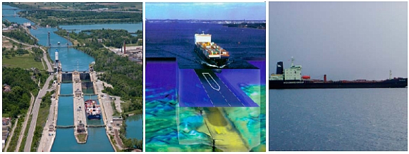
Welland Canal Flight Locks, St. Catharines, Ontario, Canada © St. Lawrence
Seaway Authority
1996 CHC poster © Canadian Hydrographic Conference
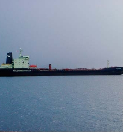
Oil Tanker M/V Tuvaq in the (Arctic) Northwest Passage © Canadian Hydrographic
Service.
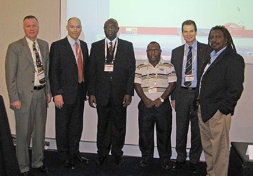
Technical Session on Capacity Building and the Economic Benefits of Hydrography,
XXIV FIG Congress, Sydney 2010. Left to right: Brian Connon USA, Gordon Johnston
(United Kingdom), Olumide Omotoso (Nigeria), Joseph Kuanda (Papua New Guinea),
Rod Nairn (Australia) and Michael Sutherland, Canada. © FIG.
Copyright © International Federation of Surveyors, June 2011
All rights reserved
International Federation of Surveyors (FIG)
Kalvebod Brygge 31–33
DK-1780 Copenhagen V
DENMARK
Tel. + 45 38 86 10 81
Fax + 45 38 86 02 52
E-mail: FIG@FIG.net
www.fig.net
Published in English
Copenhagen, Denmark
ISBN 978-87-90907-91-4
Published by
International Federation of Surveyors (FIG)
Front cover: Left: Welland Canal Flight Locks, St. Catharines, Ontario, Canada ©
St. Lawrence Seaway Authority;
Middle: 1996 CHC poster © Canadian Hydrographic Conference;
Right: Oil Tanker M/V Tuvaq in the (Arctic) Northwest Passage © Canadian
Hydrographic Service.
Back cover: Technical Session on Capacity Building and the Economic Benefits of
Hydrography, XXIV FIG Congress, Sydney 2010. Left to right: Brian Connon USA,
Gordon Johnston (United Kingdom), Olumide Omotoso (Nigeria), Joseph Kuanda
(Papua New Guinea), Rod Nairn (Australia) and Michael Sutherland, Canada. © FIG.
Design: International Federation of Surveyors, FIG
|