News in 2026

|
Happy Global Surveyors Day 21 March 2026
21 March 2026

If you have celebrated Global Surveyors Day on 21 March 2026, feel
free to write to the FIG Office at fig@fig.net with
your report. We will collect events and happenings here.
Read about:
Organised by FIG,
CASLE, and
SAGI the international surveyors community
met virtually on 20 March 2026
on the topic The vital role of local and regional organisations in
surveying, in two identical sessions during the day. An interesting
panel discussion was held and hereafter the Surveyor of the Year was
revealed: Former Surveyor General Mmuso Riba from South Africa. He was
the first black Surveyor General in South Africa and stood for Equality
and euity and a remarkable leadership, delivering non-biased solutions.
He served on UN-GGIM, and as a FIG representative to UN-Habitat. SAGI
president Peter Newmarch chaired the session. Closing remarks were
delivered by Charisse Griffith-Charles, Preident of CASLE and FIG
President Diane Dumashie.

In 2026, the Chinese Society for Geodesy Photogrammetry and
Cartography, together with the Qingdao Municipal Government, is bidding
to host the FIG Congress 2030. As a candidate host city, Qingdao carries
the mission of demonstrating China’s surveying capabilities and
conveying the importance of surveying services to society.
The event adopted the theme “Smart Mapping Connects the World,
Building a Better Future Together” aiming to present to the
world the technological capability of China’s surveying community in
supporting sustainable development goals such as land governance,
spatial planning, and climate change response, while also promoted the
bid for the FIG 2030 Congress.
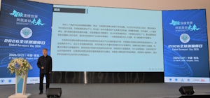
Global Surveyors Day 2026: Qingdao Hosts China’s Flagship
Event to Advance Geospatial Governance
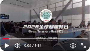
Video Account of Qingdao Media Group (QMG)
21 March marks Global Surveyors Day, an annual observance established
by FIG to recognize the foundational role of the surveying and
geospatial profession in sustainable social and economic development
worldwide. On this special day, surveyors and geospatial professionals
from across China gathered in Qingdao, a coastal city on the Yellow Sea,
to hold the national flagship event for Global Surveyors Day 2026,
celebrating the profession and uniting in support of FIG's global
mission.
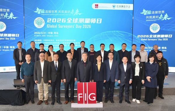
Photo source: "Panorama Studio
Under the theme Smart Mapping Connects the World, Jointly Building a
Better Future, the event was fully aligned with FIG's global call to
advance the surveying profession for global sustainable development. It
was hosted by the Chinese Society for Geodesy, Photogrammetry and
Cartography (CSGPC) and the Qingdao Bureau of Natural Resources and
Planning, and co-organized by the Chinese Academy of Surveying and
Mapping (CASM), the Geospatial Information Society of Shandong Province,
Hexagon Geosystems (Qingdao) Co., Ltd., and the Qingdao Surveying and
Mapping Institute (QSMI). More than 200 delegates attended the event,
including representatives from UN agencies, FIG Corporate Members,
leading universities, research institutions, and geospatial enterprises
from all parts of China.
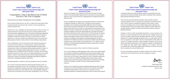
The UN Global Geospatial Knowledge and Innovation Centre (UN-GGKIC)
sent a congratulatory letter specifically for this event. In the letter,
Director Li Pengde put forward three expectations for the Global
Surveyors Day activities: first, to build a diversified and
collaborative global geospatial partnership network; second, to
strengthen the core supporting role of geospatial information in the
monitoring and evaluation of the Sustainable Development Goals; and
third, to strive to bridge the global geospatial digital divide, so that
the advantages of geospatial technology can reach the whole world
through technology sharing, capacity building, knowledge transfer and
other means.
For the Chinese surveying community, Director Li Pengde raised three
hopes: to be active participants in global geospatial governance,
pioneers and demonstrators in geospatial technological innovation, and
active promoters of international capacity-building cooperation, so as
to further enhance the key role of geospatial information in global
sustainable development.
To demonstrate the concrete actions of Chinese surveyors in actively
participating in global geospatial governance, the Chinese Society for
Geodesy, Photogrammetry and Cartography (CSGPC), together with the
Chinese Academy of Surveying and Mapping (CASM), Qingdao Surveying and
Mapping Institute (QSMI), Shandong University of Science and Technology
(SDUST), China University of Petroleum (UPC), Hexagon, CHC Navigation
and other partners, jointly launched the Qingdao Initiative 2026:
China’s Surveying and Mapping Supporting Sustainable Development. The
initiative calls on colleagues in the global surveying and geospatial
community to build consensus, deepen cooperation and address common
challenges together.
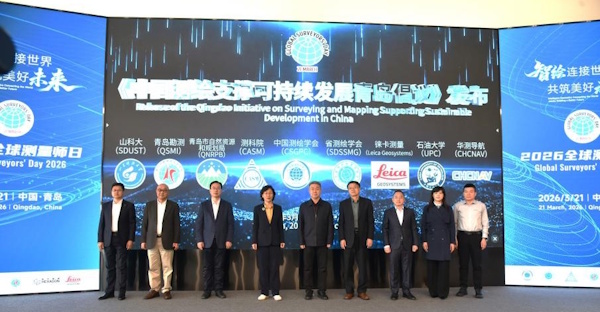
- Mr. Zhang Zhihua, Director of QSMI, delivered the initiative on
behalf of Chinese surveyors. The main contents are as follows:
Develop a global digital spatial foundation and promote the
connectivity and interoperability of geospatial data;
- Pursue innovation-driven development and accelerate research and
development of frontier technologies such as spatial intelligence and
digital twins;
- Expand the global cooperation network and deepen practical
collaboration with international organizations and national surveying
and mapping authorities;
- Uphold the green development philosophy and use geospatial
technologies to support ecological civilization;
- Cultivate world-class professionals and strengthen international
capacity building and knowledge sharing.
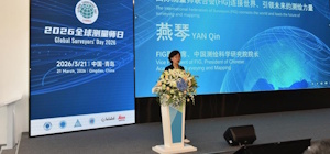
The event featured two keynote presentations. Mr. Wu Wenzhong,
Executive Vice President of CSGPC, shared insights on China’s geospatial
scientific and technological innovation and industrial development in
2025. Prof. Yan Qin, FIG Vice President and President of the Chinese
Academy of Surveying and Mapping, introduced FIG's structure, activities
and strategic direction. She encouraged the audience that China’s
surveying and mapping community should take the Global Surveyors Day
promotional event as an opportunity to further strengthen international
cooperation, build consensus across the entire industry, and form
unified national and local momentum to bid for the FIG Congress 2030.
The goal is to bring this flagship international surveying event to
China for the first time, demonstrating the firm commitment and sense of
responsibility of China’s surveying and mapping community to advance the
common development of the global surveying profession.
Senior representatives from national, provincial and municipal
geospatial authorities delivered speeches, reaffirming China’s strong
commitment to supporting FIG's initiatives and deepening international
cooperation. Qingdao is officially bidding to host the FIG Congress
2030, and all speakers pledged full support for the bid, committing to
strengthening industry collaboration, sharing Chinese expertise, and
elevating China’s role in global geospatial governance.
 |
 |
| Mr. Wu Wenzhong, Executive Vice President of CSGPC |
Prof. Yan Qin, FIG Vice President and President of the
Chinese Academy of Surveying and Mappin |
Mr. Wang Deyong, Executive President of Hexagon Geosystems Greater
China Region, stated that as a representative of FIG Platinum Members,
the company will actively practice the spirit of the Qingdao Initiative
2026, continue to promote technological innovation and deepen
international cooperation, and is committed to translating professional
capabilities in geospatial information into concrete actions that
support the achievement of the UN Sustainable Development Goals (SDGs),
contributing the industry’s wisdom and solutions to building a community
with a shared future for mankind.
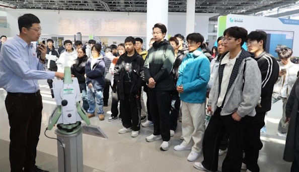
Following the meeting, delegates visited the Hexagon Hongdao Smart
Industrial Park in separate groups. As a key base in China for the
world’s leading measurement technology company, the park features
state-of-the-art surveying equipment, intelligent production processes
and cutting-edge technical applications. It is also recognized as a
National Surveying and Mapping Popular Science Education Base by CSGPC.
By experiencing the latest advances in surveying technology up close,
the delegates gained a profound appreciation for the boundless potential
of geospatial information technology in real‑world applications.
Global Surveyors Day serves as a global platform for unity, knowledge
exchange and collective action. The successful Qingdao event
demonstrates China’s open and collaborative approach to the global
geospatial community, as well as its determination to work with FIG to
improve global geospatial governance.
Chinese surveyors will continue to uphold the spirit of international
cooperation, contribute Chinese wisdom and solutions to global
sustainable development, and work hand-in-hand with the global surveying
community to build a better future for all.
Organizers:
- Chinese Society for Geodesy Photogrammetry and Cartography
- Qingdao Municipal Bureau of Natural Resources and Planning
Organized by:
- Chinese Academy of Surveying and Mapping
- Shandong Society of Surveying and Mapping
- Hexagon Surveying and Geospatial (Qingdao) Co., Ltd.
- Qingdao Survey and Mapping Institute
Co‑organizers:
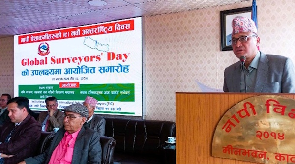
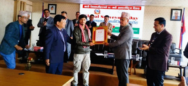
The 9th Global Surveyors’ Day was observed on March 20, 2026, in
Nepal with a formal ceremony organised by the Nepal Institution of
Chartered Surveyors (NICS), in association with the Survey Department of
the Government of Nepal. Although the Day is globally marked on 21 March
each year, this year’s celebration was held a day in advance, as 21
March falls on a Saturday.
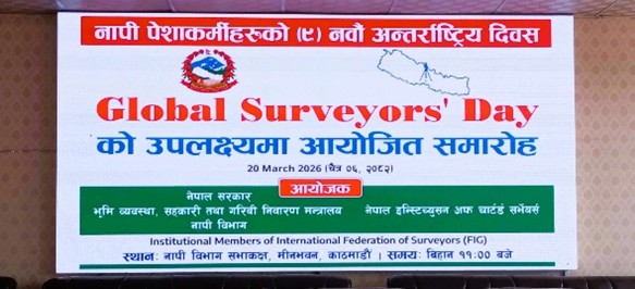
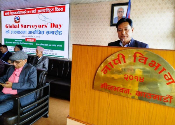
The ceremony was held at the meeting hall of the Survey Department
and was chaired by the President of NICS, Mr. Niraj Manandhar. The Chief
Guest of the event was Mr. Madan Bhujel, Secretary at the Ministry of
Land Management, Cooperatives and Poverty Alleviation. Among the
distinguished guests were the Founder President of NICS, Mr. Buddhi
Narayan Shrestha; Former President, Mr. Punya Prasad Oli; Joint
Secretary of the Ministry, Mr. Ganesh Prasad Bhatta; and Director
General of the Survey Department, Mr. Prakash Joshi, along with other
notable participants.
The Chief Guest of the event was Mr. Madan Bhujel, Secretary at the
Ministry of Land Management, Cooperatives and Poverty Alleviation
inaugurated the programme.
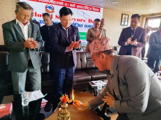
Secretary at the Ministry of Land Management Mr. Madan Bhujel
inaugurating the Global Surveyour's Day programme
Among other guests present were the Founder President of NICS, Mr.
Buddhi Narayan Shrestha; Former President, Mr. Punya Prasad Oli; Joint
Secretary of the Ministry, Mr. Ganesh Prasad Bhatta; and Director
General of the Survey Department, Mr. Prakash Joshi, along with other
notable participants. The function was chaired by the President of NICS,
Mr. Niraj Manandhar.
In his address, the Chief Guest and Secretary, Mr. Madan Bhujel,
appreciated the efforts made by NICS in advancing professional
development and assured continued support for strengthening the
profession. He also extended his congratulations to all professionals on
this auspicious occasion. The Global Surveyors’ Day may enhance the
activities on their respective field.
Secretary at the Ministry of Land Management Mr.
Madan Bhujel
The Director General of the Survey Department, Mr. Prakash Joshi,
highlighted the significant contributions of the surveying profession to
nation-building and reflected on the transformations achieved over time.
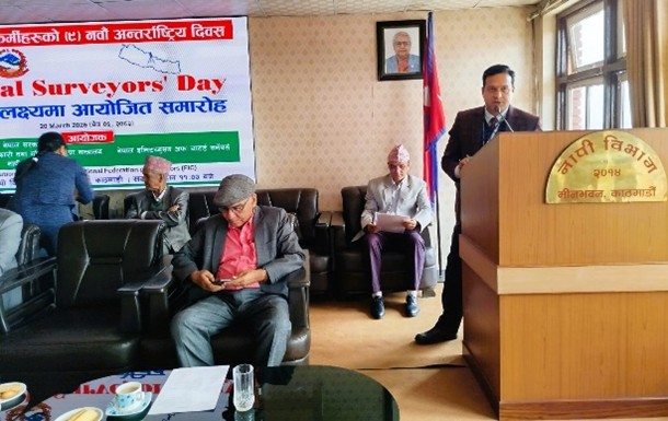
The Founder President and distinguished veteran surveyor, Mr. Buddhi
Narayan Shrestha, highlighted the activities of NICS in relation to
Global Surveyors’ Day and its engagement with the FIG. He mentioned,
Nepali Surveyors have adopted and maintained the ethics, moral and code
of conduct propounded by FIG. Global Surveyors’ Day is observed to
highlight the work of the professionals of surveying, mapping, land
administration and geo-spatial science. He emphasized the importance of
organizing such events to strengthen the professional community. He also
mentioned the candidacy of Mr. Ganesh Prasad Bhatta, Joint Secretary at
the Ministry of Land Management, Cooperatives and Poverty Alleviation,
for the position of FIG World Vice-President at the FIG Congress 2026,
scheduled to be held from 24-29 May 2026 in Cape Town, South Africa, and
extended his best wishes for success.
On the occasion, NICS felicitated outstanding graduates of 2025; the
top-performing students; from the Bachelor of Engineering in Geomatics
Engineering programmes of the three universities offering this course in
Nepal. The awardees included Mr. Indra Paudel from Tribhuvan University,
Mr. Shishir Kharel from Kathmandu University, and Ms. Shahara Shrestha
from Purvanchal University. In addition, Dr. Bhaskar Shrestha, a PhD
graduate from the University of Chinese Academy of Sciences, was also
honoured for his achievement in completing a doctoral degree in a
subject related to the surveying profession. NICS has been conducting
this felicitation programme since the inception of Global Surveyors’ Day
celebrations in Nepal.
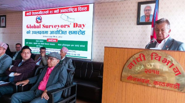
Mr. Nirmal Acharya, Treasurer of NICS, delivered the welcome remarks.
In his concluding remarks, the President of NICS, Mr. Niraj Manandhar,
extended his sincere thanks to the Chief Guest, the Survey Department
family, and all participants for their presence and valuable support in
making the event a success.
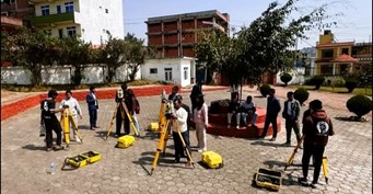
Land Management Training Centre (LMTC), Academic Member of FIG also
celebrated the Day organizing Surveying Competition on four items, such
as 1) Instrument Centering & Levelling, 2) Traverse Computation, 3)
Differential Levelling and 4) Stake out using GNSS-RTK. Forty-four
Surveyors in 19 groups had participated in the competition. Prizes were
distributed by the Executive Director of LMTC Mr. Janak Raj Joshi to the
successful Surveyors.
21ST MARCH 2026
Theme: Biodiversity, Conservation, and Restoration
In Ghana, Global Surveyors Day was celebrated by some members sharing
their work and various activities, in line with the chosen theme.
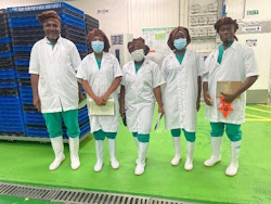 |
AnL Valuation & Properties Consult
In honor of Global Surveyors Day, we’re taking you behind the
scenes of what it truly means to be a Valuation & Estate
Surveyor. This year’s theme: Biodiversity, Conservation, and
Restoration, highlights our role as the foundation of trust in
an evolving world.
Our work often takes us far beyond the typical office setting.
Looking at this photo, you might think we’re a surgical team
prepping for a complex surgery. In a sense, we were.
To meet the rigorous hygiene standards of this food
processing facility, we swapped our standard field gear for full
scrubs and protective wear.
The attire may change, but the mission doesn’t: Precision.
Today, we celebrate the versatility of our craft. Being a
surveyor means adapting to any environment to ensure integrity
and accuracy remain uncompromised.
|
 |
Surv. Daina Ahiaku, MGhIS
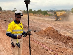
As a land surveyor in a mining environment, I'm part of a
passionate team that's all about finding balance. Our focus -
Biodiversity, Conservation, and Restoration is driven by a
shared goal: to minimize our footprint and preserve the natural
beauty of the land.
I work closely with environmental engineers, Geotechnical
engineers, farmers and to a larger extent mine community
leaders. Who are as dedicated as I am to be protecting
Ghana's incredible ecosystems. Together, we're creating
strategies to conserve sensitive habitats and restore mined
lands to their former glory.
It's tough, but it's worth it. Knowing that our work supports
local communities and preserves biodiversity for future
generations gives me a sense of pride. We're not just extracting
resources; we're stewards of the land, and that's a
responsibility we take seriously.
|
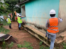 |
Surveyor Efia Dwommoh Owusu
Surveyors Efia and the Regional Land Valuation officers are
seen here checking to make sure that both the independent and
community Valuers, reference mining affected properties to GhIS
and global accepted valuation standardsOfficers of the Land
Valuation Division in the Bono Region, are seen here taking
measurements for the valuation of properties affected by mining
for the purposes of compensation.
|
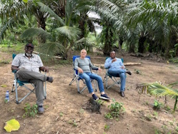 |
Surv. Kwame Tenadu Snr, Surv. Prof Cornel Paunescu & Surv.
Gustav Kplom Asamoah
Relaxing and enjoying the benefits of Biodiversity on a
plantation after a hard day of surveying in a Surveyors Farm in
Central Region.
Having more vibrant environments make work as Surveyors
possible.
It improves the quality of life and health as we traverse
large land areas across the country.
wishing you all a Happy Global Surveyors Day
|
Read about previous years of celebrations
here.
FIG Office
23 March 2026