FIG Foundation - Building a Sustainable Future

|
Aubrey Barker Fund grant, awarded to Dr. Trias Aditya, has
improved Indonesian land administration nationally
The project "A Blended Learning Course Design in Fit for
Purposes’ Cadastral Survey"

|
Project manager, Dr. Trias Aditya,
from the Department of Geodetic Engineering of Universitas
Gadjah Mada (UGM), Indonesia
|
The Aubrey Barker Fund is dedicated to enhancing
sustainable survey and land management skills in
developing countries through professional education
and capacity building for the lasting benefit of
local communities.
In 2020, The Aubrey Barker Fund, administered by
FIG Foundation, granted GBP 20,000 for two years to
the project "A Blended Learning Course Design in Fit
for Purposes’ Cadastral Survey". The project was run
by Dr. Trias Aditya from the Department of Geodetic
Engineering of Universitas Gadjah Mada (UGM),
Indonesia. Due to the Covid-19 pandemic, the
project's completion was re-scheduled for August
2024.
FIG publication basis for this project in
Indonesia
 This
project "A Blended Learning Course Design in Fit for Purposes’ Cadastral
Survey" was set in Indonesia, the home of millions of land parcels spreading
across numerous populated islands, both big and small islands, many of which
had not been mapped and registered by the country. Under the legal and
institutional framework, systematic land titling activities from village to
village were expensive and took a long time to complete. Land titling
activities were impossible without a complete cadastral map and active
participation from communities and government officers. This
project "A Blended Learning Course Design in Fit for Purposes’ Cadastral
Survey" was set in Indonesia, the home of millions of land parcels spreading
across numerous populated islands, both big and small islands, many of which
had not been mapped and registered by the country. Under the legal and
institutional framework, systematic land titling activities from village to
village were expensive and took a long time to complete. Land titling
activities were impossible without a complete cadastral map and active
participation from communities and government officers.
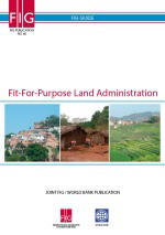
The International Federation of Surveyors (FIG) and The World Bank had
published principles and guidelines to give a way forward to accelerate the
land registration progress called
Fit-for-Purpose Land Administration (FFP-LA) (FIG Publication No. 60 by
Stig Enemark, Keith Clifford Bell, Christiaan Lemmen and Robin McLaren).
What was required in Indonesia was a paradigm shift from a top-down
traditional cadastral survey and mapping into a bottom-up modern cadastral
survey for accelerated land registration. This was lacking in Indonesia. To
effect the changes required a combination of modern survey techniques and
community participation applying FFP-LA principles in order to accelerate
and assure the quality of the land registration.
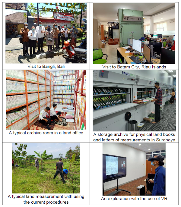
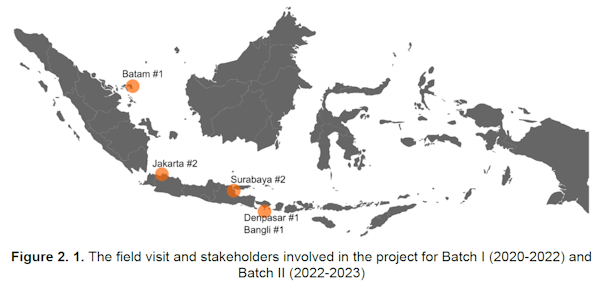
Development of a new learning platform
The project plan was to develop a learning platform applying blended
learning practices (a combination of online courses and field visit
interactions) in FFP Cadastral Survey (FFP-CS) for both in-house students
and para surveyors (i.e. local representatives in the community) across the
country. The project would develop course objectives, student outcomes and
teaching materials of FFP-CS adhering to the Accreditation Board for
Engineering and Technology (ABET) standards.
An online assessment and certification system involving the Project
Team’s University, National Land Agency and The Association of Surveyors was
also to be developed. This blended learning program would produce an
excellent capstone design for ABET curriculum and speed up the community
readiness for FFP-CS implementation.
Land registration challenge accepted
Fit-for-Purpose (FFP) Land Administration has been
tested and implemented world wide. Although there has been a comprehensive
implementing guidelines available (Enemark, McLaren and Lemmen, 2015),
finding the really fit land registration method suitable for a country
context was not easy. Managing the financial, political, legal and
administrative risks associated with large-scale registration campaigns were
crucial. Indonesia’s progress on land registration program provided a good
context to try out how quality, cost, and speed of land administration
services should be accelerated extending stakeholder interaction. A
combination of modern survey techniques and community participation applying
Fit for Purposes (FFP) Land Administration principles would accelerate and
assure the quality of the land registration.
Project results improving land registration for
Indonesia nationally
Dr. Trias Aditya led the succesful project "A Blended
Learning Course Design in Fit for Purposes’ Cadastral Survey" towards
impressive project results:
-
The project developed a set of learning materials
applying blended learning practices in FFP Cadastral Survey (FFP-CS) for
both in-house students, surveyors and para surveyors (i.e. local
representatives in the community) across the country.
-
The project developed course objectives, student
outcomes and teaching materials of FFP-CS.
-
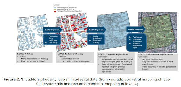
The training module was developed accordingly
with the focus on the cadastral data quality improvements.
-
The publications have been successfully produced.
-
The project has helped the Indonesian
government in developing some regulations (technical guidelines and
ministry regulation) in regard to data quality improvements and
participatory approaches as well as AR/VR adoption to the national land
registration program.
Read the full report
FIG Office
30 September 2025
|


