FIG Task Force on Geospatial Information Ecosystem
The Role of FIG in International Trends and Future Geospatial
Information Ecosystem
The Task Force was established at the FIG Working
Week in Orlando, Florida, USA in 2023. The term of this Task Force is 2023-2026.

This Task Force centred upon the involvement of FIG members in
geospatial fields to re-position their international standing and assert
the essential relevance of geospatial experts in international markets.
The main objectives of the Task Force are to: assess and improve the
impact of FIG for its members and partners (existing and new partners);
assess and improve the role of FIG in international trends and future
geospatial information ecosystem, as well as the role of members in global
geospatial market; and provide recommendations for FIG Council to adopt
and implement the outcomes of the setout objectives.
Its expected outcome is to reinforce and grow FIG’s influence as a key
and influential organization within the global geospatial data ecosystem,
and the outputs could include a FIG booklet, series of
reports/recommendations/contributions to the development of FIG
profession.
Join the Task Force on LinkedIn
You can follow the task force on LinkedIn at:
https://www.linkedin.com/showcase/fig-geospatial-task-force
The Trends and Future Geospatial Information Ecosystem at FIG Working Week
2023
The task force was established at the FIG Working Week 2023 in Orlando,
Florida, and its Terms of Reference was approved by FIG General Assembly
on 28 May 2023 as well as the appointed chair Abbas Rajabifard.
During the Working Week the FIG Director Generals Forum was contested
by the new FIG-Task Force on “The Role of FIG in International Trends and
Future Geospatial Information Ecosystem”. Members of the Task Force
provided background information, which was followed by a moderated panel
discussion, aimed to seek opinions and input from the attending Director
Generals.
Opening and Welcome by Daniel Steudler and Abbas Rajabifard
[handouts]
UN-GGIM Perspective on Geospatial Information Trends by Greg Scott
[handouts]
Task Force on “The Role of FIG in International Trends and the Future
Geospatial Information Ecosystem” by Hartmut Müller
[handouts]
Scenario Study on Future Land Administration by Fredrik Zetterquist
Strategy Drivers of Land Administration Authorities in Europe by Kirsikka
Riekkinen
[handouts]
Moderated Panel Discussion
Top
1. Background
As the leading and premier international organization representing the
interests of surveying, land and geospatial practitioners worldwide, it is
essential that FIG continually reviews its role and function to remain
relevant, and maintain its international impact while providing services
not only to its members but also its global partners. FIG needs to
consider its role in relation to its international standing and leadership
in the geospatial arena, now and for the future.
In recent years we have seen significant changes in the markets and
within the profession. The geospatial industry and land professions are
dealing with major global challenges such as rapid urbanisation and the
effects of climate change. FIG wishes to examine its role, as well as the
functions and competencies of surveyors, to make sure they remain aligned
with international trends and domain specific drivers which shape our
industry. This will empower FIG to be fit for the future both within the
geospatial market and in the wider and emerging digital transformation
markets.
FIG will focus on maintaining and enhancing its professional relevance
for a wider societal benefit, recognising the pivotal role that geospatial
data plays as an enabler particularly in land administration. This is in
the context of the UN Sustainability Agenda as well as international
trends and emerging geospatial information ecosystem.
FIG needs to identify the current and potential reach and the impact it
can contribute to wider geospatial areas such as Big Data and AI. This is
a broad agenda and FIG needs to assess how it can work with other
organisations, such as UN-GGIM, to improve its impact . The drive is that
FIG aims to play a thought leadership role to create a better market for
FIG members in emerging geospatial fields.
With this, the Task Force centred upon the involvement of our
profession in geospatial fields to re-position its international standing
and assert the essential relevance of geospatial experts in international
markets. Geospatial data is a component of systems in all sectors. As
such, it is expected that other professions will see geospatial as
important, but the Task Force aims to secure the role of the geospatial
expert in these domains.
The Task Force will be cognisant of what is happening in the FIG
commissions, in order to strengthen their roles and capabilities and also
avoid duplication. The Task Force will be clear in its purpose and will
report to Council and the General Assembly (GA).
2. Objectives of the Task Force
The main objectives of this Task Force are:
- to assess and improve the impact of FIG for its members and
partners (existing and new partners).
- to assess and improve the role of FIG in international trends and
future geospatial information ecosystem, as well as the role of
members in global geospatial market.
- to provide recommendations for FIG Council to adopt and implement
the outcomes of the above objectives.
The Task Force will present periodic reports to Council and other
relevant channels on their findings concerning current FIG role in Global
Geospatial market trends. The Task Force will undertake its work via a
unified, collaborative, transparent and consultative approach together
with the FIG members. In this context, the general discussions points can
be:
- What are the strengths of FIG members?
- What do FIG members currently do?
- Why is it relevant?
- How to position FIG members in current international context?
- What is the evidence of benefit of FIG members as we shift to
massive, 3D, real-time data underpinning all aspects of our lives?
- Literature review: What is the evidence base?
- Professional assurance of accuracy, precision, knowledge of
fit-for-purpose data, privacy/security etc.
3. Terms of References
In the context of its objectives, the Task Force aims to deliver two
achievements:
- Assessment and analysis of FIG’s current impact:
- How is impact currently achieved by partners and members?
- Investigation of current trends and initiatives
- Identification of priority areas in-line with FIG Members
- Assessment and review of international trends and future
geospatial information ecosystem:
- Review of FIG’s current and potential partners and activities
- Mapping of interrelations between FIG commissions, networks
and international entities
- Identification of challenges and opportunities including new
regions and markets
Top
4. Outcomes and Outputs
The outcome for this Task Force is to reinforce and grow FIG’s
influence as a key and influential organisation within the global
geospatial data ecosystem. This will be delivered through analysis of
international trends, identification of areas where FIG can and does have
the most impact, and the development of roadmaps to align with FIG members
and partners.
Outputs could include…a FIG booklet, series of
reports/recommendations/contributions to the development of FIG profession
(etc). The details of these outcomes will be listed in the advanced work
plan.
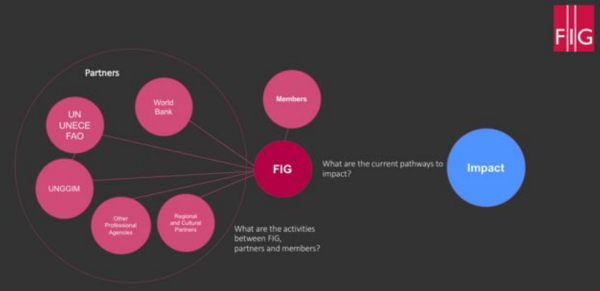
5. Pathway and Implementation
A work plan will be created by the Task Force to list the activities
and milestones in response to its objectives and deliverables. The Task
Force will focus on:
- The current pathways to impact.
- A “SWOT” analysis of the FIG current strategy and operation, its
activities with major partners and members, and possible a
benchmarking with other organisations including UN-GGIM be performed
and involves FIG Council.
- Trend analysis to better understand potential future directions of
development and to ascertain the readiness of FIG in this context.
- Mapping of interrelations between FIG commissions, networks,
partners, and international entities. • Identification of challenges
and opportunities and main international players and authorities
including new regions and markets.
- Development and preparation of reports on the Task Force findings,
and recommendations to Council.
- The Task Force will complete its work in 3 years and the final FIG
Booklet publication be ready for release at the FIG 2025 Working Week
in Brisbane.
Whilst the Task Force will have the responsibility for implementing
TOR, the team will undertake this via a unified, collaborative, and
consultative approach with all FIG members. In other words, the Task Force
will identify, consult, and discuss with our internal and external
stakeholders what we are doing well, what we can do better, challenges or
trends affecting influencing the future, and how to resolve such matters.
6. Proposed Work Plan
With respect to the work plan, it is expected and highly recommended
that the Task Force:
- Forms and begins work as soon as possible
- Develop a detailed work plan with expected milestones and
deliveries at upcoming annual FIG events and other significant events
to address and achieve objectives.
- Develop a detailed work plan that presents ways for transparency
and interactions with FIG and its members and other geospatial
partners to address and achieve objectives
- Support FIG to asses and improve its role regarding international
trends and future geospatial information ecosystem, as well as the
role of members in global geospatial market, with the development of
an action list with activities for FIG to consider
- Propose methods on how to review the impact of these activities
- The work programme will be done through email, online meetings and
where feasible “face to face” meetings will be organised to coincide
with FIG related events.
Here is a snapshot of the deliverables and schedule:
| Activities |
Aims |
Expected Delivery |
| TOR Council Approval |
TOR Approval |
February 2023 |
| TF and TOR General
Assembly Approval |
FIG Working Week
Orlando |
May 2023 |
| TF detailed Work Plan
development with expected milestones and deliveries |
Detailed Work Plan |
July 2023 |
| Assess 1:
SWOT analysis of the FIG current strategy and operation, its
activities with major partners and members |
Evidence base for
impact of FIG |
Aug-Dec 2023 |
| Mapping of
interrelations between FIG commissions, networks, partners, and
international entities |
|
Oct-Dec 2023 |
| Assess 2:
Review of International geospatial trends and future ecosystem |
To better understand
potential future directions of development and to ascertain the
readiness of FIG in this context |
2023-2024 |
| Identification of
challenges and opportunities for FIG and main international
players and authorities to interact |
|
2024 |
| Conduct a series of
open seminars/panel discussions/workshops (virtual/f2f) to
identify and capture relevant inputs for the operation and the
communications of the TF |
At least one activity
per year, and in 2025 the activity would be to launch the outcomes
of the TF |
2023-2025 |
| Regular Reports on
the TF findings, and recommendations to Council |
|
2023-2025 |
| Final Publication- a
Strategy Roadmap |
For release at the
FIG 2025 Working Week in Brisbane |
June 2025 |
Top
The TF Co-Chairs will be from two different FIG regions. Co-Chairs will be
responsible for creating the Work Plan for each year of the TF, as well as
a Four-year overall work plan for the TF. Co-Chairs will be responsible
for undertaking annual reviews of the TF’s performance and annual
reporting to FIG Council. The TF Core Team will consist of a minimum of 8
members. Across these there is a representative from each FIG region, and
a fair mixture of Young Surveyors and seasoned surveyors. Core team
membership currently stands as:
Prof Abbas Rajabifard (Chair)
 |
Prof Abbas Rajabifard is an internationally recognized
scholar and a proud surveyor and a geospatial engineer with over
30 years of experience. He is an active leader in research and
development in land administration system modernization,
sustainability and resilience.
Prof Abbas is Director of Research Centre for SDIs and Land
Administration, and also Discipline Leader for Geomatics at the
University of Melbourne. He is also a Member of the United Nations
International Advisory Board for Global Geospatial Knowledge and
Innovation Centre (UN-GGKIC) and also a Board Member for the
United Nations-Academic Network for Global Geospatial Information
Management (UN-GGIM). Prof Abbas is one the world pioneer
technical architect for the development of Digital Twin platform
for smart cities and urban analytics. Over the last decade, he has
worked on strategic projects in Asia-Pacific (Malaysia, Indonesia,
Singapore, HongKong, China, India, Solomon Islands), Europe, North
America, and Latin America regions, where he has developed the
strategy, design, and implementation of policies and technologies.
Prof Rajabifard has also published widely in the domain of land
and location intelligence and smart city solutions.
|
Dr Kirsikka Riekkinen (Deputy Chair)
 |
Dr. Kirsikka Riekkinen is an assistant professor in land
management at Aalto University, Finland. Kirsikka holds a PhD
degree in real estate economics since 2014. Her research is
focused on land administration and cadastral systems, as well as
land consolidation. Kirsikka is currently vice chair of FIG
Commission 7
|
Surv. Adamu Bala (Secretary)
 |
Surv. Adamu Bala has been a Lecturer in the Department of
Geomatics, Ahmadu Bello University, Zaria, Nigeria, since 2018;
and presently, a PhD candidate with a major in Surveying and
Mapping Sciences and Technology at the China University of
Geosciences, Wuhan, China. Before then, he had worked with an
engineering consultancy firm and a federal government research
institute as a Surveyor and a Geoscientist, respectively. Surv.
Bala is a mentor at the FIG Africa Regional Network, a member of
many professional bodies; a Registered/Licensed Surveyor and also
an Examiner with the Surveyors Council of Nigeria. He is equally
the Chief Editor of the Geoinformatics Forum Magazine.
|
He has received numerous recognitions and awards such as the: “2022
FIG-Survey Review Biennial prize”; “2022 Distinguished Young Surveyor
Award”; “2022 Young Surveyors’ Academic Scholar with Excellence Award”;
“The President of the Nigerian Institution of Surveyors 2023 Merit award”;
“Outstanding Participant certificate at the 2023 International Geomatics
Summer School at the LIESMARS”; “the xyHt geospatial magazine`s one of the
23 Young Geospatial Professionals to watch in 2023”; “the Geospatial
World`s one of the 50 Geospatial Rising Stars for 2023”; “the 2023 ASPRS
Student Conference Presentation grant”; "1st prize in the semi-final, and
Best Creative project award in the final of the China-Africa Youth
Innovation competitions, in Shanghai and Wuhan, respectively" and an also
appointed as an International Admission Ambassador of the China University
of Geosciences, Wuhan, China, 2023. He has attended and fully participated
in numerous international conferences, competitions, and also authored and
published peer-reviewed research papers in several local and international
journals.
Dr Daniel Steudler
 |
Dr Daniel Steudler holds a PhD degree from the University of
Melbourne, Australia and is a scientific associate with the Swiss
Federal Office of Topography swisstopo, working for the Federal
Directorate for Cadastral Surveying. He has been active in
FIG-Commission 7 for many years and was chair of the FIG-Task
Force on «Spatially Enabled Society». He published widely in the
cadastral field and consulted internationally in land
administration and cadastral issues. Since March 2015, he is chair
of the EuroGeographics "Cadastre and Land Registry" Knowledge
Exchange Network. He is Vice-President of FIG in the period
2023-2026.
|
Prof. Hartmut Müller
 |
Prof Hartmut Müller is professor emeritus+ at University of
Applied Sciences Mainz, Germany. He received his diploma and
doctoral degree in Geodesy from Karlsruhe University, Germany.
Until 2019 he was founding director of Mainz University’s
Institute for Spatial Information and Surveying Technology. He
serves on editorial boards of journals and book series. His
research interests are in the areas of geospatial information
management, spatial data infrastructures, and quality of
geospatial data. From 2015 to 2018 he was working group chair of
FIG International Federation of Surveyors, from 2019 to 2022
commission chair, and from 2021 to 2022 representative of the
Advisory Committee of Commission Officers to the FIG Council.
|
James Norris
 |
James Norris is the International Policy Lead at Ordnance
Survey where he works to promote the vital role that geography and
geospatial data has in transforming economies, sustaining the
environment, and making the world a better place.
He is a Fellow of the Royal Geographic Society, and works
across several domains in the geospatial information sector. Most
recently promoting the work of UN-GGIM. James has written several
international policy documents including the UN-GGIM’s ‘Future
Trends in Geospatial Information Management: 5-10-year vision
Second Ed.’ and was a contributing author to the UNDRR ‘Global
Assessment Report on Disaster Risk Reduction 2019’ where he wrote
about 'Changes in technology and data sharing'. He recently wrote
a UN-GGIM Discussion Paper on ‘Geospatial Information for Climate
Resilience – What does UN-GGIM do?’. James is committed to
outreach and advocacy in the geospatial domain and is part of
several outreach initiatives including the Association for
Geographic Information’s Early Careers Network which promotes
opportunities for professionals with less than 10 years industry
experience.
|
Dr. Ryan Keenan
 |
Dr. Ryan Keenan is Chair of FIG Commission 5 Positioning and
Measurement, and an active member of the FIG Asia Pacific
Capability Development Network (AP CDN). Ryan is the FIG
Representative to the United Nations’ Sub-Committee on Geodesy
(SCoG), an industry member of two UN-GGIM Working Groups, an
industry member of the UN-GGIM Private Sector Network (PSN) and an
individual member on the UN Global Geodetic Centre of Excellence
(GGCE) International Advisory Committee (IAC). As Principal
Consultant at Positioning Insights in Melbourne Australia, Dr.
Keenan provides bespoke advisory services to global public and
private sector organisations, on how satellite- and
terrestrial-based positioning technologies can be best applied to
overcome increasing challenges across multiple markets.
|
Menare Royal Mabakeng
 |
Menare Royal Mabakeng is currently a lecturer specializing in
Land Administration within the Department of Land and Spatial
Sciences at Namibia University of Science and Technology.
Simultaneously, she is pursuing her PhD in Integrated Water
Resources Management. Her research is centred on the utilization
of open land data to promote tenure security, address water tenure
issues, and facilitate participatory informal settlement
upgrading. Specifically, her work explores the impact of
community-generated land-related information on vulnerable
populations, with a particular focus on women and young
individuals residing in informal settlements. Within NUST, she
contributes her expertise to various courses, including those
focused on Innovative Approaches to Land Administration, Land
Policy and Development, Project Management for Land Administration
and Information Systems Law. Royal holds a Master of Science
degree in Earth Observation for Land Administration from the
University of Twente, Faculty ITC in the Netherlands.
|
Mikael Lilje
 |
Mikael Lilje is the Head of the International Department at
Lantmäteriet (the Swedish mapping, cadastral and land registration
authority). The department is responsible for the international
services that Lantmäteriet is involved in, mainly in Africa and
the Balkans. The Department is also supporting the Director
General and her management board in co-operations like UN, UNGGIM,
EuroGeographics and other important international organisations.
Mikael has been active in FIG since 1998 and is currently Council
member. Previously, he has been chair of the Task Force on
Commission Structure, Chair of FIG Commission 5 (2011-2014),
working group chair (2002-2016, 2006-2010) and Commission
secretary 1998-2002. He was acting as FIG liaison to UNOOSA
between 2011-18 and has organized numerous technical sessions and
seminars. Mikael was co-chair of the working group on Strengthen
Capacity Development within the UN-GGIM High Level Group on IGIF
as well as leading the UN-GGIM Subcommittee on Geodesy working
group on Education, Training and Capacity Building. He has been
representing Sweden in the UNGGIM Subcommittee on Geodesy Bureau.
|
Rosario Casanova
 |
Rosario Casanova is a professional land surveyor from Facultad
de Ingeniería, Universidad de la República, Uruguay. Prof.
Casanova has a master’s degree in Planning and Land Development
from and a Doctorate degree in Land Surveying. She has been
professor at the Land Surveying Institute in Uruguay for almost 30
years, being the Senior Lecturer of the Geomatic Department of
that Institute. She was the Director of the Land Surveying
Institute from 2014 until 2020. Prof. Casanova has been professor
and researcher of Lincoln Institute of Land Policy, Programa para
América Latina y el Caribe, since 2005. Dra. Casanova is member of
different academic networks related with the geographical
information, especially she is the chair of the Academic Network
of UN-GGIM: Americas, she is the vice-chair of Commission 2:
Professional education of International Federation of Surveyors
(FIG) and recently she was appointed as the vice-chair of the FIG
Regional Network, America. In the national level she is serving as
Vice-President for the National Society of Professional Surveyors
in Uruguay (Asociación de Agrimensores del Uruguay).
|
Fredrik Zetterquist
 |
Fredrik Zetterquist is a geospatial and land administration
expert with 20+ years of experience from international
engagements. Between 2017 and 2023 Fredrik was chair of the UNECE
Working Party on Land Administration. Since 2019 his permanent
position is as Programme Faculty Director for a 5-year study
programme in geospatial information science at the University of
Gävle, Sweden.
|
Top
|


