The science of measurement (instrumentation, methodology and guidelines)
The acquisition of accurate and reliable survey data related to the
position, size and shape of natural and artificial features of the earth and
its environment and including variation with time.
Mission statement
The mission of Commission 5 is to:
focus on modern technologies, technical developments and assist
surveyors, engineers and GIS/LIS professionals through guidelines and
recommendations, to choose and utilise those methods, technologies and
instruments that are most appropriate to different applications.
facilitate and follow technical developments through collaboration with
other FIG Commissions and other international organisations; participation
in appropriate meetings; and the preparation of appropriate publications.
foster and support research and development and stimulate new ideas in
the fields of expertise represented within the commission.
formulate and formalise collaboration with manufacturers on the
improvement of instrumentation and associated software.
FIG Events - present and promote the work of the Commission and its
working groups on an on-going basis at FIG Working Weeks, FIG Regional
Conferences and other relevant technical meetings and in appropriate FIG and
other media.
General
This work plan covers the development, use and integration of technologies
for positioning and measurement and the associated standardisation, best
practice and fundamental reference frame issues. Many of the issues are global
in nature and Commission 5, along with many other associations, are well suited
to tackle the technological challenges that we face. FIG Council has also
requested the Commission 5 to cooperate with the United Nations agencies to
address global problems such as sustainable development and humanitarian needs,
where disciplines covered by Commission 5 are at the heart of delivering
solutions for the spatial aspects of these important global problems. Specific
activities aimed at developing countries include examination of Low Cost
Surveying Technologies, assistance with implementation of modern Geodetic
Reference Frames and associated infrastructure and contribution to appropriate
Continuing Professional Development programmes.
In addition to the specific activities above, Commission 5 will support and
contribute to FIG Task Forces and Networks, especially to the Standards Network.
Working Group 5.1 - Standards, Quality Assurance and Calibration
Policy Issues
Influence the development of standards affecting positioning and
measurement instruments and methods, in collaboration with the FIG Standards
Network and through participation in the relevant technical committees (TCs)
of the International Standards Organisation (ISO) and other appropriate
bodies.
Acceptance controls, quality assurance and certification and their
impact on the surveying profession.
Testing and calibration of measuring instruments.
Assist other Commission Working Groups to implement Standards from TC
172/SC 6 and ISO TC211 as appropriate
Chair
David Martin
FRANCE
E-mail: martin[at]esrf.fr
Specific project(s)
Develop a summary guide on instrument testing following the principles
laid out in the ISO standards related to Optics and optical instruments –
Field procedures for testing geodetic and surveying instruments.
Present and promote the use of standards and guidelines to the surveying
community.
Establish guidelines and recommendations for instruments taking into
account latest development in surveying technology.
Promote guidelines and recommendations based on the ISO Guide to
Uncertainty of Measurements (GUM) and its supplements.
Review Standards coming from ISO TC211 for relevance to Positioning and
Measurement.
Workshop(s)
Participation in FIG Working Weeks and other major Commission events (see
events section below) with dedicated technical sessions and/or workshops as
appropriate.
Publication(s)
Summary guide on instrument testing following the principles laid out in
the ISO standards related to Optics and optical instruments - Field procedures
for testing geodetic and surveying instruments.
Timetable
Draft publications will be presented at FIG Working Weeks during the term
of this plan and according to a timetable to be developed by the Working Group
Chair.
Realising tutorials and workshops on topics of interest and related
questions during the whole period
Facilitating special sessions in FIG events (FIG Congress, FIG Working
Weeks, and FIG Regional Conference) as well as other special events when
appropriate.
Working group final report and outcomes will be presented at dedicated
session, FIG Congress, 2014.
Beneficiaries
FIG member associations, manufacturers and users of survey equipment,
governments, standardisation organisations, decision makers, GIS developers
and users, surveying businesses, individual surveyors
Work to bring together all organisations involved in defining or
using reference frames to develop common approaches and avoid
duplication. Such organisations include FIG, the International
Association of Geodesy (IAG), ISO, groups of national mapping agencies,
other influential national agencies (such as the US Department of
Defence’s National Geospatial-Intelligence Agency (NGA), which is
responsible for WGS84.) and alliances of commercial organisations (such
as Open GIS Consortium and the European Petroleum Survey Group).
Continue the existing co-operation with IAG on the Regional
Reference Frame Projects such as AFREF, APREF, EUREF, NAREF, and SIRGAS.
Consider options for the development and implementation of
4-dimensional datums that incorporate the effects plate tectonic and
regional effects such as those due to earthquakes or local effects such
as landslides.
Provide background technical information on relevant issues written
in a way that is accessible to the surveying practitioners.
Develop an inventory of approaches to reference frame issues in
different countries (including transformation methodologies) that is
accessible to surveying practitioners.
Examine how surveying practitioners can access the reference frame,
through less emphasis on networks of ground monuments and more emphasis
on Global Navigation Satellite Systems (GNSS) base stations.
Provide information on the maintenance of CORS networks to ensure
long-term stability
Liaise with Commission 4 to review, revise and update FIG
Publication 37, Vertical Reference Surface for Hydrography
Chair
Graeme Blick
NEW ZEALAND
E-mail: gblick[at]linz.govt.nz
Specific project(s)
Initiate, contribute and facilitate meeting(s) of all organisations
involved in defining or using (regional) reference frames to develop common
approaches and avoid duplication.
Continue development of Technical Fact Sheets that briefly explain basic
concepts, practical applications and issues and which summarise the
activities of organisations with specific responsibilities in the field.
Ensure terminology used in above publications conform to and give
substance to the relevant Standards coming from ISO TC211.
Begin a forum to discuss the implementation of 4 dimensional datums.
Ensure that the working group web page is updated and accessible.
Workshop(s)
Participation in FIG Working Weeks, FIG Regional Conference and other
major Commission events (see events section below) with dedicated technical
sessions and/or workshops as appropriate.
Realising tutorials and workshops on topics of interest and related
questions during the whole period.
Facilitating Special Sessions on FIG events like FIG Congress, FIG
Working Weeks, and FIG Regional Conference as well as on additional special
events like ICG meetings as well as IAG-symposium.
Publication(s)
Maintaining and developing the Web page
FIG Working Weeks will include technical papers on specific issues and
presented by Working Group members and other invited experts.
Technical Fact Sheets as outlined above.
Timetable
Draft publications will be presented at FIG Working Weeks during the term
of this plan and according to a timetable to be developed by the Working Group
Chairs.
Working group final report and outcomes will be presented at dedicated
session, FIG Congress, 2014.
Working Group 5.3 - Geodetic and Positioning Infrastructure
Policy issues
Examine the positioning services using CORS.
Examine various positioning techniques using GNSS
Examine existing automated positioning software via WWW
Real time networks
GNSS products and advancements
Provide FIG input during planning and implementation phases
associated with programs of GPS Modernisation and GNSS Development.
Chair
Neil D. Weston
USA
E-mail: Neil.D.Weston[at]noaa.gov
Specific project(s)
Report on the development, possibilities and limitations of new
technologies (e.g. via web pages) for surveyors regarding GNSS infrastructure
and Positioning techniques.
Prepare guidelines for practitioners on making the best use of systems
to achieve the results required for particular applications.
Realising tutorials and workshops on topics of interest and related GNSS
positioning techniques.
Facilitating Special Sessions in FIG Events (FIG Congress, FIG Working
Weeks, and FIG Regional Conferences) as well as other special events when
appropriate.
Develop FIG input to GPS Modernisation and GNSS Development.
Provide a yearly summary on milestones achieved with regard to GNSS
infrastructure (constellations, signals etc.).
Collaborate with other Commissions and other international organisations
(including IAG and ISPRS) and with equipment, software and service
providers.
Continue commitment to relevant inter-disciplinary events including the
series of Symposia on Machine Guidance and Control (joint with IAG and
ISPRS).
Workshop(s)
Participation in FIG Working Weeks and other major Commission events (see
events section below) with dedicated technical sessions and/or workshops as
appropriate.
Publication(s)
Guidelines on making the best use of emerging systems.
Guidelines for practitioners on making the best use of systems to
achieve the results required for particular applications.
Yearly summary on milestones achieved with regard to GNSS infrastructure
(constellations, signals etc.).
Timetable
Draft publications will be presented at FIG Working Weeks during the term
of this plan and according to a timetable to be developed by the Working Group
Chair.
Working group final report and outcomes will be presented at dedicated
session, FIG Congress, 2014.
Beneficiaries
FIG member associations, manufacturers and users of survey equipment,
governments, standardization organizations, decision makers, GIS developers
and users, surveying businesses, individual surveyors.
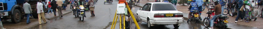
Most surveyors can operate and manage their instruments if no movements
occur. But what happens, if the instrument or the surveyed object is moving? New
problems arise like e.g. synchronisation of the measurements and modeling of the
movement. These and other related tasks, investigations and practical solutions
are summarized under the term “kinematic measurements”. Multi-sensor-systems and
their application play an important part for kinematics.
If you are interested in this topic related to monitoring as well as machine
guidance, then you should definitely join this group to share your experience or
learn from others. We will organize sessions at FIG events, participate at
symposia on related topics e.g. “Machine Guidance and Control” and “Mobile
Mapping” and facilitate the interchange of knowledge among practitioners and
researchers.
Policy issues
Cooperation with all organisation involved in the field of GNSS e.g. IAG
and ISO
Bring to together practitioners, instrument manufactures and scientists
that deal with kinematic measurements
Maintaining contact with instrument and sensor manufactures to provide
state-of-the-art information to the users
Co-operation with Commission 6 WG “Machine Guidance and Control”
Co-operation with study groups IC-SG2 and IC-SG3 of the Intercommission
Committee on Theory (ICCT) of the International Association of Geodesy
Publications (e.g. via web) and a special issue in a well-known
scientific journal about the following topics:
Kinematic aspects of geodetic instruments like total stations
and GNSS receivers as well as with typical kinematic sensors like
inertial measurement units, odometers, etc.
Time issues like synchronisation and dead time.
Integration of different sensors to Multi-Sensor-Systems.
Quality of integrated kinematic measurements
Workshop(s)
Realising tutorials and workshops on interesting topic related questions
during the whole period.
Facilitating Special Sessions on FIG Events like FIG Congress, FIG
Working Weeks, and FIG Regional Conferences
Facilitating on additional special events, e.g. Mobile Mapping
Technology Symposium, Krakow, Poland, 2011, 1st International Workshop on
the Quality of Geodetic Observation and Monitoring Systems, Munich, Germany,
2011 and 3rd International Conference on Machine Guidance and Control in
Stuttgart, Germany, 2012.
Technical Papers at Working Weeks, Regional Conferences and Commission 5
Symposia and Workshops
Providing technical background information (e.g. via web pages) for
surveyors dealing with kinematic tasks and applications during the whole
period.
Providing a Special Issue of a well-known scientific journal e.g. the
Journal of Applied Geodesy in 2013/14
Publication(s)
Technical papers at Working Weeks, Regional Conference and Commission 5
symposia and workshops
Providing technical background information (e.g. via web pages) for
surveyors dealing with kinematic tasks and applications during the whole
period.
Providing a Special Issue of a well-known scientific journal e.g. the
Journal of Applied Geodesy in 2013/14
Timetable
Working group final report and outcomes will be presented at dedicated
session, FIG Congress 2014.
Beneficiaries
FIG member associations, manufacturers and users of survey equipment,
decision makers, surveying businesses, individual surveyors, scientists.
Working Group 5.5 – Ubiquitous Positioning
(Joint Working Group with Commission 6)
This group, which is a joint working group between FIG and IAG, will
focus on the development of shared resources that extend our understanding
of the theory, tools and technologies applicable to the development of
ubiquitous positioning systems. It has a major focus on;
Performance characterization of positioning sensors and technologies
that can play a role in the development of ubiquitous positioning
systems
Theoretical and practical evaluation of current algorithms for
measurement integration within ubiquitous positioning systems.
The development of new measurement integration algorithms based
around innovative modeling techniques in other research domains such as
machine learning and genetic algorithms, spatial cognition etc.
Establishing links between the outcomes of this WG and other IAG and
FIG WGs (across the whole period)
Generating formal parameters that describe the performance of
current and emerging positioning technologies that can inform FIG and
IAG members.
To be held in conjunction with Mobile Mapping Technologies (MMT)
Symposium, Krakow, Poland 2011
Further activities:
Participation in FIG Working Weeks and other major Commission events
(see events section below) with dedicated technical sessions and/or
workshops as appropriate.
Several papers submitted by working group participants to FIG
meeting in Morocco, 2011.
Several papers to be submitted by working group participants to MMT,
Poland, 2011.
New algorithms for dynamic modeling and data fusion in real-time
underway.
Website for sharing code and data to be established
Publication(s)
Technical Papers at Working Weeks, Regional Conference and
Commission 5 Symposia and Workshops
Reporting on the performance characteristics of a broad range of
MEMS inertial sensors derived from extensive practical testing and
benchmarking. (2011-2012)
Reporting on performance characterization of positioning
technologies the development, possibilities and limitations of new
technologies. (across the whole period)
Establishing components of an open source platform for researchers
to rapidly deploy sensors as well as evaluate and develop integration
algorithms. (across the whole period)
Developing and report on taxonomy for users of ubiquitous
positioning systems that shows the performance capabilities of sensors
and typical applications. (across the whole period)
Timetable
Working group final report and outcomes will be presented at
dedicated session, FIG Congress, 2014.
Joint Study Group 6.2.2 on Laser Scanning
Jointly with Commission 6 (Commission 6 has lead and work plan is
described in Commission 6 work plan)
Co-operation with Other Commissions
Study Group 6.2.2 – Laser Scanning (Commission 6 has the lead)
Working Group 5.5 – Ubiquitous Positioning Systems (Commission 5 has
lead)
Commission 5 will collaborate with Commission 4 to review and revise
(where required) FIG Publication 37, Vertical Reference Surface for
Hydrography.
Commission 5 will also collaborate with other FIG Commissions as
appropriate.
Co-operation with United Nation Organisations, Sister
Associations and other Partners
Commission 5 is the lead Commission for the Memorandum of Understanding
between FIG and the United Nations Office for Outer Space Affairs (UN-OOSA).
ICG (International Committee on GNSS) will be the focus of cooperative
activities from 2011 to 2014. FIG is co-chairing the Task Force on Geodetic
Reference Systems together with IAG and IGS.
Commission 5 is also committed to cooperation with sister associations,
especially the International Association of Geodesy (IAG) with which FIG has
a Memorandum of Understanding. Commission 5 has also specific liaison
interest with the International Society for Photogrammetry and Remote
Sensing (ISPRS) and the Permanent Committee on GIS Infrastructure Asia
Pacific (PCGIAP). The Commission 5 Steering Committee will ensure that
Working Group activities and Commission 5 events further these goals of
cooperation with sister associations. For example Commission 5 endeavour to
assist with projects, create publications and facilitate events that are
agreed with IAG on topics such as:
AFREF - African Reference Frame
APREF - Asia Pacific Reference Frame
Reference systems/ frames,
GNSS CORS and the use of IGS products
Mobile Mapping Technology
Optical 3-D Measurement Techniques
Deformation Measurement
Ubiquitous Positioning (together with FIG Commission 6)
Vertical Reference Systems
Commission 5 is also committed to the Cooperation Agreement with the US
based Institute of Navigation (ION) and will undertake activities as agreed
with ION, especially in relation to GNSS.