News in 2018

|
FIG Asia Pacific Capacity Development Network Report from the Congress
7 May 2018, Istanbul, Turkey
As the FIG Asia Pacific Capacity Development Network Chair a special
forum on “Asia Pacific Capacity Development Network” was convened, and
an invitation to participate in the United Nations Geodesy Sub-Committee
on “Education Training and Capacity Building in Geodesy” forum as the
FIG nominee was accepted . As the titles suggest both forums were
intrinsically linked with respect to geodetic capacity development
activities and the plans for the future. The total number of the
delegates at these forums was almost 60.
Although time was limited, there was some interesting discussions
that occurred in each forum. The dialogue by the participants was
a result of “flash” but stimulating presentations, which were focused on
topics such as -
- Geospatial challenges and trends
- Role and Activities of - Manufacturers, Survey & Mapping
Agencies, Professional Organisations, UN GGIM
- Qualifications, Mutual Recognition
- Draft of the UN GGIM Geodesy Sub-committee Education, Training
and Capability Building strategy
- Surveyors in the Digital World
- Women in Surveying
- Pacific Geospatial Surveying Council 10 year Strategy
Note - to view the presentations please navigate to the formal
proceedings of both sessions that were held on Monday 7 May 2018 –
http://www.fig.net/fig2018/technical_program.htm
From the discussions a summary of the forums outcomes for the FIG
General Assembly was prepared, and is as follows –
Recognising the global geospatial information challenges and trends,
such as
- Impact of rapid urbanisation, and smart cities
- Influence of disruptive technologies and digitisation
- Permeation of ubiquitous positioning into the community
- Earth dynamics and modernisation of geospatial reference systems
- Importance of building resilience for disasters / emergency
management
Surveyors MUST enhance their capabilities to tackle these challenges.
To develop their capability Surveyors (and agencies) need to initially
consider –
- Formulating a capacity building strategy, framework and
implementation plans for the sub regions of Asia and the Pacific
that focus on the needs / priorities
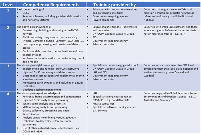
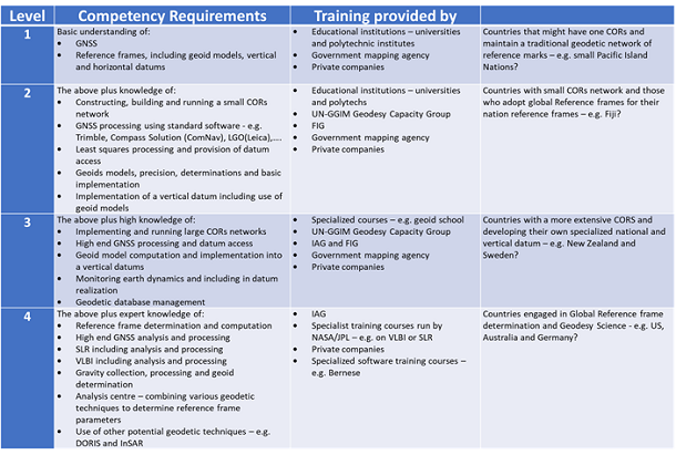
- Identifying core competencies for geospatial / geodetic
surveying (see table below)
- Investigating who can provide the required professional
development
- Examining mutual recognition of survey qualifications
- Further collaboration with FIG AP CDN, UN GGIM AP, UN ETCB
Moving forward the FIG AP CDN, UN GGIM AP Working Group 1, and UN
ETCB will prepare proposals to the relevant hosts to convene a –
- Workshop for decision makers to discuss and form a capacity
development plan for geodesists / surveyors in Asia and the Pacific.
Location - Deqing, China Nov. 2018 @UN World Geospatial Information
Congress; UN GGIM AP Plenary
- Technical workshop on GNSS CORS infrastructure and operations
for the Pacific Island Countries and Territories. Location - Nadi,
Fiji Sept / Oct 2018 @ Pacific Geospatial Surveying Council meeting.
Furthermore follow up meetings should occur at -
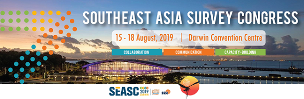
FIG Working Week, April 22-26, 2019 in Hanoi, Vietnam. For more
information, please visit
www.fig.net/fig2019
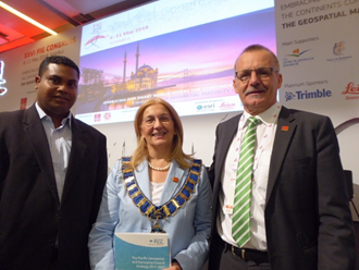
Finally a special highlight at the FIG Congress was the presentation
of the “Pacific Geospatial Surveying Council 10 year Strategy –
Positioning the Pacific Islands for the Future” to current FIG President
Ms. Chryssy Potsiou, and the incoming FIG President Mr. Rudolf Staiger
by the Fiji’s Surveyor General Mr Asakaia Tabua. To view the strategy
please navigate to here
Rob Sarib
June 2018