This workshop
was jointly organised by the International Federation of Surveyors (FIG) - Commission 3, the German Association of Surveying (DVW) - Society for Geodesy, Geoinformation amd Land Management, Working Group 2 (Spatial Information and Spatial Data Management) and i3mainz - Institute for Spatial Information and Surveying Technology, Mainz University of Applied Sciences.
Objectives
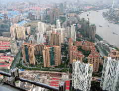
The aim of this workshop is to study the economic, social and environmental impact of rapid urban growth, unplanned in many countries, and use international knowledge and experience on how surveyors may assist real estate markets, good governance, environmental management and planning initiatives by providing reliable Spatial Data Infrastructures (SDIs) in order to:
- Emphasize the significance of reliable SDIs as the necessary tool for managing the city “chaos” and allow for vitality and “openness to change”,
- Research how traditional SDIs may be appropriate for the scale and dynamics of mega cities,
- Clarify the needs for spatial data infrastructures (SDIs) providing reliable information about real estates relevant to ownership rights, value, land-use regulations and land development procedures to support efficient decision-making,
- Identify current needs for new land tools and policies to attract investment, optimize real property taxation, support valuation, and provide tools for affordable housing and financing, for rejuvenation of dilapidated areas, for maintenance of the old buildings to satisfy new needs, and for the support of real estate markets,
- Investigate community based data collection; examine appropriate land tools, software, and geospatial data sources, and outline possibilities of spatial urban data capture, structure, use, discovery, integration and exchange,
- Promote the 3D modeling of urban processes using SDI; exchange knowledge and experience in the creation of virtual urban environments to support navigation, exploration, tourism and other innovative uses,
- Investigate examples of good practice in spatial information management and propose appropriate organizational structures, administrative, fiscal and legislative tools for rapidly growing urban areas,
- Promote the multiple use of spatial data to support citizens interaction, employment, public health, tourism, entertainment, education, culture; to stabilize the economy and support the sustainable development of urban areas; and identify the role of the private sector,
- Make suggestions for future research directions, e.g., modern public sector responsibilities and good governance policies for transparency, access to information, citizen empowerment, participation, safety, security, freedom, and equality,
- Explore the future of SDIs in risk prevention and disaster management, fresh-water and energy supply, waste management, informal settlements management, planning, transportation, pollution and crime control in urban areas.
|
|