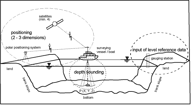
SURVEYING OF WATERS IN THE FRG BY THE FEDERAL WATERWAYS AND SHIPPING ADMINISTRATIONDr.-Ing. Joachim BEHRENS, GermanyKey words: hydrography, surveying of waters, surveying system for "peilungen", echosounder systems, Federal Waterways and Shipping Administration. OVERVIEWNow I'm over 20 years at the Federal Institute of Hydrology (BfG := Bundesanstalt für Gewässerkunde) in Germany. Our main task at the BfG is to look forward for future developments in hydrography - especially to optimize the complex systems for surveying of waters. So I will give You an impression of the Federal Waterways, as the surveying object, the organization of the Federal Waterways and Shipping Administration, and - very important - the instruments and the rules for the daily tasks we used for the surveying of waters today. 1 INTRODUCTION1.1 The Federal Waterways in FRGThe length of the Federal Waterways in FRG is about 7.300 km, 800 km from that are so-called sea waterways. Opposite to that the inland waterways are decided in free flowing rivers, channelized rivers (whose streaming water is regulated by locks), and canals. 75 % of the river net belongs to natural beds by streaming water, and the other part is constructed by mankind. The Federal Waterways are in the right of possession of FRG. The regulations and especially the rivers and their length are described in the Federal Waterways Act in FRG, the Bundeswasserstraßengesetz (BWaStrG 1990). As FRG is situated in the heart of Europe, so the Federal Waterways have a central importance for European Waterways and their navigation traffic. The main rivers of FRG are Rhine, Danube and Elbe, where you can find most traffic activities. 1.2 The Federal Waterways and Shipping AdministrationThe Federal Waterways and Shipping Administration (WSV := Wasser- und Schifffahrtsverwaltung) is responsible for the Federal Waterways and has to supervise the navigational traffic routes and the traffic itself. The flood, the waste water from industry and the water quality - by mentioning some of the essential topics - is in the responsibility of the 16 States of FRG. Only if there is a conjunction with navigational traffic, then the WSV has been involved. The organization of the WSV is: the Federal Ministry of Transport, Building and Housing (BMVBW), the 7 regional Waterways and Shipping Directorates (WSD'en, plural), the 39 local Waterways and Shipping Offices (WSÄ) and 8 Offices for Planning and Construction (NBÄ). In addition to this organization there are the Federal Institute of Hydrology (BfG), the Federal Institute of Hydraulic Engineering (BAW) and Federal Maritime and Hydrographic Agency (BSH) as principal authorities of FRG under the jurisdiction of BMVBW (Behrens 1992b). As the author is Head of Department "Geodesy" of BfG some information are necessary to explain. The BfG is the scientific institute of the Federal Government for research, assessment, and consulting in the fields of hydrology, water-resources management, ecology and water conservation. It acts as consultant for federal ministries and their subordinated authorities in general and detailed decision-making, especially for WSV in matters of regarding the planning, development and new construction of Federal Waterways as well as their operation and maintenance (BWaStrG 1990, § 45 (3)). The main tasks of Department "Geodesy" in the field of surveying of waters are research, development of instruments, surveying systems and measuring methods as consultation, support or assistance and aid for the WSV. 2 SURVEYING OF WATERS2.1 In GeneralSurveying of waters consists in measuring the morphology of the water bed, that means the form and topography of the shores and banks, including the underwater banks and slopes and the bottom. These three-dimensional co-ordinates (triples) are recorded, in dependence on the special water region, with systems aboard vessels / boats or, in certain cases, with simple surveying instruments from shore or bank. Measuring vehicles like measuring vessels, amphibian vehicles (Behrens 1986), trailerable boats or barks, are used, which have special standards in construction and motorization to meet the requirements of the area to be surveyed and of the surveying equipment (Behrens 1988). The two-dimensional position of the measuring vehicle (e.g. latitude and longitude or other national co-ordinate systems) is determined by position fixing systems using various methods. The measurement of water depth or sounding is made from the surveying vessels mostly with echosounders or echosounder systems. The measured depth data are related either to the surveying vessel or to the surrounding water surface. The data of positioning and of depth sounding have to be assigned together simultaneously (Behrens 1988). If there are shallow waters or if trailerable boats or amphibian vehicles are not available, only tachymeters with prismatic rod or sounding rod are used. It is in any case important to ensure the flow of data because of the immense recorded information. For the later use of the data triples - especially for comparison with data from earlier surveying epochs or campaigns - the measured water depth data have to be related to a mostly homogeneous levelling reference system, cf. figure 1. The main task of the WSV is to guarantee the safety of navigation on the Federal Waterways in Germany requires the permanent monitoring of the morphology of the waterway beds and of the changes they undergo. These measuring exercises, called in German "Peilungen" consist of the following operations:
Figure 1: Principle of surveying of waters by vessel or boat The extent and the accuracy of surveying tasks is to be optimizes, depending on the demands brought forward by the multi-users of the data, for instance in the field of maintenance dredging, development or new construction of waterways. Mostly the surveys are so-called multi-purpose surveys, with the intention to optimize the quality (i.e. accuracy) of the measurements and to chose the most economical method. 2.2 Surveying System for "Peilungen"On the Federal Waterways surveying systems for "peilungen" are used. This surveying system is installed on board the measuring vessels. This system has 3 main components, which are equal to a higher data processing level by the stream of data sampling:
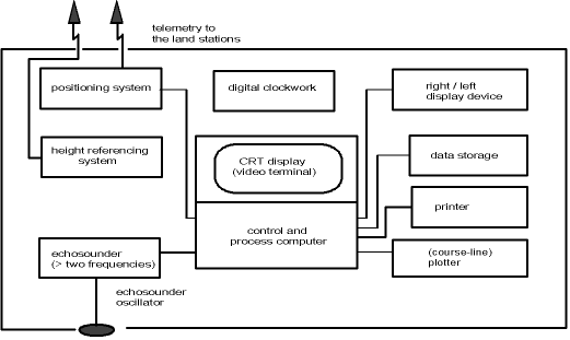
The sensors are normally: the positioning board system, inclusive an antenna or prism circle outside the steering house, the echosounder system, inclusive the acoustic oscillator (transducer) and the height referencing system, cf. figure 2. If needing highest accuracy, it is necessary to have a motion sensor (for heave, roll, pitch) and a gyro compass for the stability of the surveying vessel (as the platform for all sensors) in the short moment of measurement during practical work. If you will not work with tide gauges, when working in near distances (until 500 m) to the boarders of the river, so-called niveaulaser systems are in use (Behrens 1993). Another way of work is to use the vertical angle of polar-fixing systems or nowadays the use of satellite positioning systems.
In general there is a data-flood and for the hydrographer it is necessary to get the sensor-data into the processor for calculating and navigating for the helmsman. The raw data with so-called first plausibility on board are recorded on CD's. This is a very difficult process, because the surveying system for "peilungen" must be able to decide, that the correct time for each sensor-measurement is chosen. Only by this the calculation of the co-ordinates P(X, Y, Z) for each bottom-point is truthful possible. By our researches over a period of years we can mention, that the minimum time for position data must be better than 2 data per second. The minimum time for sounding data must be better than 10 data per second. The data for the height reference of depth measurements must be close to the positioning data rate. Besides that there is often the problem to have acknowledge over the stabilisation of the measuring vessel itself. For that high precise surveying of waters, we use sensors for heave, pitch and roll too. In 1994 / 95 a lot of trials had been made to install the Hydrographisches Mess- und Auswertesystem (HYMAS) - a modern combined surveying system for "peilungen" - on board the 16 m surveying vessels for use on Federal Waterways. The components of HYMAS are PDGPS (cf. chapter 2.3), a single beam echosounder system with 2 frequencies (e.g. 15 kHz / 100 kHz), a multi tasking processor unit and a lot of software modules (develop by firms and the staff of Department "Geodesy"-BfG) under Windows NT is leading the measurements from the beginning to the end of surveying work. The software is able to recognize mistakes, defects or failure data from the sensors during the process on board. It is a great help for the operator and the helmsman, seeing the complete documentation - not only for the surveying data - on the processor screen. This HYMAS are in use since the end of 1995 in WSA Cologne for a river part of the Lower Rhine Region (Brüggemann 1995). Until today there are in use about 20 surveying vessels with HYMAS for inland waterways. The recorded data are given to a computing centre in a local Waterways and Shipping Office (WSA := Wasser- und Schifffahrtsamt). There a second plausibility will be used for the combination of the data sampled for each surveying track to a digital river-bottom modelling. Other results are drawings of profile tracks, depth figure or depth-lines charts, difference depth-lines charts and digital cartographic information for different users. The intern users in the WSV are responsible for navigational safety, dredging, hydrology, inspection of all sorts of underwater buildings and planning and new construction of waterways. 2.3 Positioning SystemsSince 1995 in the WSV the instruments for surveying of waters had been changed extremely. The ancient radiolocation systems like HiFix (since 1969, until 1985), MiniRanger III / IV (since 1980, until 1991 for both tidal rivers Elbe and Weser) and Syledis (since 1983, until 1998) as succeeding system of HiFix had been used in the coastal zones of FRG in North Sea and Baltic Sea (Behrens 1996). These - in their technology very good - systems are exchanged by Navstar Global Positioning System (GPS) or in the modifications: by Differential-GPS (DGPS) or by Precise-DGPS (PDGPS). For the inland waterways there was a change from manual works: positioning by ropes or steel wires for each meter or Ralog 20/22 to polar positioning systems like Polarfix (since 1983), Polartrack (since 1990) or Autotracker (since 1991). This was a development which was increased by BfG (by my predecessor in the office: Mr. Meiswinkel 1983). The famous of this instrumentation was the automatic tracking by infrared laser and prediction of positioning, during the measuring signal had been lost about some seconds. It was an expensive polar positioning system (about DM 250,000), but it is today not out of order. The most use is in river regions with e.g. numerous bridges, harbours, high buildings and mountains, which are close to the waterways. It is often better to use the Polartrack than GPS, because the GPS signal noise is often bad or there is no measuring signal at all (Wirth, Gertig 1991, Behrens 1992a). For the WSV some staff-members of Department "Geodesy"-BfG had been made a lot of experiences from 1990 until 1993 with DGPS an later on with PDGPS. These tests ended successfully for use of PDGPS aboard the surveying vessels (Wirth 1990, Wirth, Brüggemann 1993). Another famous thing was, that the Geodetic Survey of the 16 States of the FRG decided to build up the so-called SAPOS (Satellite Positioning Service of the German National Survey of the 16 States of FRG). Normally the GPS-reference stations have range distances about 50 km over the whole area of the States; that means over FRG. Along the Rhine river the GPS-reference stations are combined by SAPOS and some stations of those from WSV (Behrens 1999a). By this there is a higher density at a range distance of about 20 km, so that the accuracy is about s > = 10 cm (P = 95 % confidence level) for positioning in real-time. By the use of all kind of positioning systems in daily practice at the Federal Waterways we develop accuracies for position fixing of the surveying vessels / boats. Long-years of practical experience have shown that the systems can yield accuracies in the following ranges, in dependence on the quality of the systems and the handling of the operators (with statistical accuracy of 95 percent):
2.4 Echosounder SystemsI myself remember of the manual position fixing on rivers as an old method on the one side, and on the other side as a method nearby depth founded buildings in practice today. To this method belongs manual depth measuring by plumb, and the length of the rope or steel wire, which crosses the water, must be measured to know the full meter points of the depths (Behrens 1999b). Otherwise there is no use of high technology like laserscanning systems with green shining laserbeam, which comes through the water-body more than 10 m of depth. But in FRG the quality of water is not so clear for that kind of measurement, and the given accuracy of about 30 cm per 10 m of depth is too bad for the navigational safety of Federal Waterways. The depths of these river routes is about 3...5 m in average, for the canals about 5 m. That is the reason why the WSV has to look for every decimetre of depth more or less, and there is need of systems for shallow waters. Sometimes the intern user of data want to know a higher resolution of depth measuring ("only few centimetres"!), when modelling with hydrographic data. That is why the WSV use the special echosounder systems for surveying adapted to the regional conditions of rivers or canals. The measuring principle of echosounding is the following one: Sound impulses generated by an oscillator propagate through the medium water until they hit on an interface between two media which differ in density, like water and river bottom, where they are reflected and received by the same or a second oscillator (transducer). The travel time of the signal is recorded and the distance is calculated, which is the depth of water vertically below the oscillator, cf. figure 1 (Behrens 1988). The following factors have to be considered in echosounding measurements:
The data of water depth measured by sounding are to be considered as raw information about the water depth below the immersed oscillator and the time of the recording. To enable comparisons with future measurements, it is necessary to bring these raw data into relation to a fixed permanent levelling system. In hydrology, the common reference systems are the mean sea level, the zero of level of sea charts, or reference gauges. The network of fixed points along waterways is connected to the network of fixed points of the superordinated land surveying system and supplies height and position references for engineering purposes. The height of these fixed points is determined by so-called main levelling exercises along the Federal Waterways which are repeated very 10 to 15 years. Simultaneously with these measure-ments, for each water level gauge, the so-called zero-of-gauge level is fixed by means of three gauge reference points. Since the supply of height reference data for measurements on inland waterways is beyond the scope of this paper, it should be mentioned that such examples can be found in the literature (Behrens, Henoch, Keydana 1990; Behrens 1993). As the network of gauging stations on coastal waters and tidal rivers is wide-meshed (distance normally more than 10 km) and the stations are mostly located near the coast, reference data here can today be supplied only by help of compu-ter models, which are able to consider the influences of the tides. The best accuracy achieved here is in the decimetre range. Especially for coastal waters and tidal rivers, a substitution of the conventional reference data supply by a DGPS could yield notable improvements for the methodology and in accuracy. A precondition is the existence of a homoge-nous height reference system on a nation-wide scale and in the whole of Europe, as well as the use of suitable geoid models for the oceans and seas.
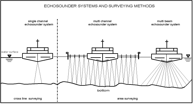
Figure 3: Principles of echosounder systems for cross line and area surveying All three main groups of echosounder systems: single and multi channel and multi beam echosounder system are in use today for getting surveying profiles or a complete information (depths, topology and morphology) of the whole river or canals body, the coastal bottom as well as the water areas of harbours, cf. figure 3 (Behrens 1999b). I think we take and had been taken that special echosounder system, which is and had been demanded by each different user of surveying information. Now I will give You some experiences with the two novel systems: electro-acoustic "peilrahmen" - a high precise multi channel echosounder system - and multi beam echosounder system for use on Federal Waterways in FRG. In 1996 the BfG had become order to made researches on multi beam echosounder systems for use in shallow waters. We had got an overview after looking at the international market, especially the firms: L3-Communications Honeywell Elac, Reson, Simrad and STN Atlas Elektronik. The staff-members of "Geodesy"-BfG made together with members of WSA Duisburg-Rhine a lot of trials with the Simrad EM 3000 system of about 4 weeks in the Lower Rhine Region near by Duisburg in 1997. The handling with the system, the installation on board and the resulting accuracies in the Rhine river as well as the recognition of underwater buildings, of locks and of obstacles had been the main aspects during the tests (Wirth, Böth 1997). Here are some results of the tests with Simrad EM 3000. The multi beam echosounder system data can be used until 8 times the water depth, e.g. 8 x 3 m = 24 m is the width of the surveying lane on the bottom. The accuracy is about s = 10 cm (P = 95 % confidence level) under mentioned conditions. The accuracy of the vessel stability itself to a fixed position is on average 11 cm under a measurement velocity of 2 m / s. A large multi channel echosounder system have 40 m width, but the extend metallic construction needs a big vessel and demands for a very good steering by helmsman. So it is easier to use multi beam echosounder system, although you need twice lanes for surveying the same bottom area. In 1997 the BfG together with the WSA Regensburg (Danube) made researches on a new constructed electro-acoustic "peilrahmen". It has 33 transducers (3 per 1 m of length) for vertical sounding installed in a row on a metallic mounting. This construction is a mobile one and can be changed from one surveying vessel / boat to another. The manufacturer is Dr. Fahrentholz from Germany (Kiel). The electro-acoustic "peilrahmen" has the best use for finding small obstacles on the river bottom, because the sounding signal rate is 40 times / s (= 40 Hz). There is exactly the same accuracy as with multi beam echosounder system, but the costs are cheaper and the surveying lane on the bottom is 11 m. As a conclusion out of the testing results, it is necessary to reduce the digital data for both echosounder sytems. The data density must be reduced in that way, so that after computing and data plausibility the whole bottom area is characterized by single but essential points of obstacles (Wirth 1999). I think for that aspect and for handling the huge mass storage of data, an enormous task is to do in future for all hydrographers! After ending the both tests described above with reports (Wirth, Böth 1997, Böth 1998), the BfG developed a long list on the performance characteristics which must be necessary, if one WSA will buy a multi beam echosounder system. It was worth to do that for such kind of complex system! It was very difficult to get all information from the firms, because some parts or modules of the systems had to be develop in future and some descriptions are not so quite specified for the user. Today there are 6 multi beam echosounder systems in use on the Federal Waterways in FRG and 4 systems are purposed for the next two years. 2.5 Special Measuring MethodsIn the surveying of the beds of water bodies, one distinguishes between the measurement of longitudinal and cross profiles and the area measurement. The choice of the surveying method depends on the availability of instruments, the type of ship and the surveying equipment on board for "peilungen". Multi-purpose measurements are given preference to supply several users with data (choice of the most economical method) in sufficient accuracy for fields like navigational safety, dredging, hydrology, planning and implementing works in hydraulic engineering. In coastal waters, and partially also in tidal rivers, the distance between the sounding lines varies between 50 m (in the demarcated navigation channels) and 400 m (over tidal flats). The presently used system operates with single oscillator echo-sounders (e.g. 100 kHz), often supplemented by oscillators for a second, lower frequency (e.g. 15 kHz) for distinguishing silt and sediments. Today for that special surveying there are special instruments in use with developments in future (Wendt 1999, Eden 1999). Of course, priority is given to navigation channels against the other areas in the regular updating of surveys. The results of the surveys are available to users in form of digital data (WSV-point file), as representations of cross sections or depth charts, depth contour charts, and the Maps of Federal Waterways in large scale (e.g. 1:2,000). These maps are produced and regularly updated in the mapping departments of the WSV or ordered from private firms. I just want to mention that the digitalized Map of Federal Waterways in the scale 1:2,000, which shall also be the basis for a future information system on waterways, is in the process of preparation. 3 FACIT, FUTURE ASPECTSThere is on the one side the development of the components and of the whole surveying system for "peilungen". On the other side there is the interest of people outside the Federal Waterways and Shipping Administration (WSV), who want to buy the data information getting by the surveying of waters, for aiding the traffic vessel navigation. The last aspect leads to a river-channel information system called ARGO for the Rhine river, as the most traffic river of the Federal Republic of Germany today. Instead of that, it will be used an automatic navigation system, researched and developed by the University of Stuttgart, and an inland waterway chart on the basis of ECDIS. In the automatic navigation system there will be a radar map matching, controlled by DGPS with an accuracy of abut 3 m in X/Y-positioning for the merchant ship using ARGO. If we look at the inland waterway chart, so it is necessary to get the Z-co-ordinates, represented by the depth data from the surveying, with an accuracy of about 20 cm. The problem of course is the actualisation of the data for each bottom-point P(X, Y, Z) out of surveying of waters. This is an optimization of men power, number of measuring vessels and financial resources for the WSV. This needs a very good planning and organization with a help by a quality assurance system until a certification analogue to ISO 9000 (DIN). Regular monitoring of sea waterways and inland waterways by surveying demands the application of advanced modern technology. While the topic surveying system for "peilungen" is already rather complex, it is becoming even more complicated by the intensive use of information processing technology for each measuring operation by vessel. From a point of view of economy, the number of data recorded should be also guided by the requirements of multi-disciplinary use of the geometric information after surveying and other information of experts, which are connected with the geometric data. That is why the operation of the complex measuring systems should be entrusted to well trained staff so that the necessity of a future repetition of these expensive measuring operations can be avoided. Often, it is not possible to repeat the surveying within a reasonable time, or at all, because of extraordina-ry events (extreme water stages). The application of novel technology should be delayed until sufficient experiences have been gathered, so that the continuity in the transition from the older concept of measurement to the newer one is not disturbed. REFERENCESBehrens, J.: Untersuchung zur Tiefenmessgenauigkeit unter Einsatz eines Messfahrzeugprototyps. Zeitschrift für Vermessungswesen 111, S. 41-42, Stuttgart 1986. Behrens, J.: Zur Genauigkeit von Peilungen in der Gewässervermessung (Diss. 1987). Wissenschaftliche Arbeiten der Fachrichtung Vermessungswesen der Universität Hannover, Nr. 151, Hannover 1988. Behrens.J., Henoch, H., und Keydana, W.: Future concept for inspecting the stream-flow regime on the Niederrhein: Increasing the accuracy of depth soundings by application of land-based laser Systems. 27th International Navigation Congress, Osaka, May 20 - 26, 1990, Sect. l, Subj. 1, p. 45 - 52. Behrens, J.: Der Einsatz von GPS in der Gewässervermessung für die Wasser- und Schifffahrtsverwaltung des Bundes. In: Anwendungen des Global Positioning Systems, 25. DVW-Seminar, 18.-19.02.1991, Universität Hannover. DVW-Schrif-tenreihe Nr. 2. S. 154-167. Konrad Wittwer Verlag, Stuttgart 1992a. Behrens, J.: Gewässervermessung auf Bundeswasserstraßen. In: Vorträge zum 76. Dt. Geodätentag, Hamburg 16.-19.09.1992. Zeitschrift für Vermessungswesen 117, S. 507-516, Stuttgart 1992b. Behrens, J.: Gewässervermessung (Surveying of Waters). In: Schwerpunktthema: "Hydrographie". Zeitschrift für Vermessungswesen 118, S. 143 - 151. Stuttgart 1993. Behrens, J.: Gewässervermessung an Bundeswasserstraßen - heute und im Jahr 2000. In: Festschrift 60. Geburtstag Prof. Dr. mult. H. Pelzer. Wissenschaftliche Arbeiten der Fachrichtung Vermessungswesen der Universität Hannover, Hannover 1996. Behrens, J.: DGPS bei der Gewässervermessung (DGPS for Surveying of Waters). In: GPS-Praxis und Trends, 46. DVW-Seminar, 29.09. - 01.10.1997, Frankfurrt/M.. DVW-Schriftenreihe Nr. 35, S. 358 - 375. Konrad Wittwer Verlag, Stuttgart 1999a. Behrens, J.: Echolote -- Historie und Überblick (Echsounder Systems -- History and Overview). In: Gewässervermessung und Hydrographische Informationssysteme. 49. DVW-Seminar, 28.-29.09.1999, TU Dresden. DVW-Schriftenreihe Nr. 37, S. 54 - 75. Konrad Wittwer Verlag, Stuttgart 1999b. Böth, H.: Evaluation of a Shallow Water Multibeam Echosounder for Inland Waterways. Proceedings of Canadian Hydrographic Conference. Victoria, British Columbia, March 10-12, 1998. Brüggemann, Th.: Hydrographisches Mess- und Auswertesystem (HYMAS) mit satellitengestützter Ortung für den Binnenbereich der Bundeswasserstraßen. BfG-Bericht 0902, Koblenz Juni 1995. BWaStrG: Bundeswasserstraßengesetz i.d.F. vom 23.08.1990, BGBI. L S. 1818. Eden, H.: Detection of Sediment-Layers and Properties (DSLP)-Method - A New Serving Technology (Das DSLP-Echolotverfahren - eine neuartige Vermessungstechnologie im Einsatz). In: Gewässervermessung und Hydrographische Informationssysteme, 49. DVW-Seminar, 28.-29.09.1999, TU Dresden. DVW-Schriftenreihe Nr. 37, S. 106 - 115. Konrad Wittwer Verlag, Stuttgart 1999. Meiswinkel, H.-G.: Atlas Polarfix - ein neues Ortungssystem hoher Genauigkeit für den Einsatz auf Binnenwasserstraßen. Zeitschrift für Vermessungswesen 108, S. 127 - 129, Stuttgart 1983. Wendt, G.: Die Vermessung von Meeres- und Gewässerböden mit parametrischen akustischen Sediment-Echoloten. In: Gewässervermessung und Hydrographische Informationssysteme, 49. DVW-Seminar, 28.-29.09.1999, TU Dresden. DVW-Schriftenreihe Nr. 37, S. 89 - 105. Konrad Wittwer Verlag, Stuttgart 1999. Wirth, H.: Untersuchung der erreichbaren Ortungsgenauigkeit mit dem Verfahren Differential-GPS (DGPS), Teil l. BfG-Bericht 0571, Koblenz Juli 1990. Wirth, H., Gertig, R.: Messprogramm zur Beurteilung der Genauigkeit von Polarortungs-systemen dargestellt am Beispiel des POLARTRACK Laser Tracking System. BfG-Bericht 0619, Koblenz Juli 1991. Wirth, H., Brüggemann, Th.: Untersuchung der erreichbaren Ortungsgenauigkeit mit dem Verfahren Differential-GPS (DGPS). Teil II. BfG-Bericht 0777, Koblenz Oktober 1993. Wirth, H., Böth, H.: Untersuchung zur Eignung von Fächerlotsystemen für den Einsatz auf Bundeswasserstraßen. BfG-Bericht 1082, Koblenz September 1997. Wirth, H.: Flächenhafte Plausibilisierung von Peildaten. In: Gewässervermessung und Hydrographische Informationssysteme, 49. DVW-Seminar, 28.-29.09.1999, TU Dresden. DVW-Schriftenreihe Nr. 37, S. 117 - 130. Konrad Wittwer Verlag, Stuttgart 1999. CONTACTVDir. Dr.-Ing. Joachim Behrens 11 April 2001 This page is maintained by the FIG Office. Last revised on 15-03-16. |