CADASTRE 2014: FROM THEORY TO PRACTICEJürg KAUFMANN, SwitzerlandKey words: CONTENTS
1. CADASTRE 2014At the XX FIG Congress 1994 in Melbourne was given the task to FIG Commission 7's Working Group 7.1 to investigate cadastral reforms and to develop a vision how cadastral systems would look like in about 20 years to be able to better satisfy the needs of the steadily developing humankind. The terms of reference for Congress Working Group 7.1 were to:
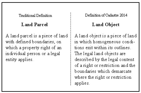
The result of this work was published as a brochure with the title 'Cadastre 2014, A vision for a future cadastral system' [Kaufmann, Steudler, 1998]. It was presented at the FIG Congress in Brighton. Studying the existing literature and the experience being gained in ongoing cadastral projects and having close contacts with the Office Internationale du Cadastre et du Registre Foncier, OICRF - an institute of FIG - gave a clear view of the role and principles of cadastre and the importance of the security it provides for the coexistence and economic activities of humankind. Economic development on the basis of a functioning land market is only possible when land matters are settled in a legally correct way and within a secure legal environment. The findings were that the traditional principles of cadastre are proven and true and must be the basis for modern cadastres as well. After a wide-spread survey of existing cadastral systems and the reasons and aims of the ongoing cadastre reforms, and a second enquiry into the development of privatization and cost recovery in the different cadastre institutions, the deficiencies of existing cadastres and the trends in development have been identified. It became clear that the documentation and registration of private land rights does not provide enough information to assemble a complete picture of the legal situation of land. The legal situation has changed remarkably in the last few decades because societies had to introduce new legislation under public law which had impacts on private land rights. In the interest of a careful utilization of land, land use planning was established, and new laws were aimed at better protecting the environment and the people living in it. The exploitation of limited natural resources was regulated. All these new laws, in a certain sense, favor sustainability but have an impact on the private property rights. It can be considered as a fact that further legal regulations will and must be implemented to resolve the problems caused by the world's growing population and changing ways of living. This is in the sense of sustainability but the danger exists that all these regulations hinder development and even sustainable development. Furthermore, all these regulations touch the absolute rule of the land owner. Modern cadastres must take into consideration this development but they must also follow the proven principles of the traditional cadastre. Cadastre 2014, therefore, enlarges the objects to be processed by the cadastre and the content of cadastral systems. The new objects to be processed are the land objects. Land parcels are a category of land objects (Figure 1).
Figure 1. Definition of land objects The content of modern cadastres take into consideration all land objects in a defined area. A definition for Cadastre 2014 may be found in figure 2.
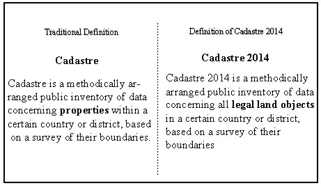
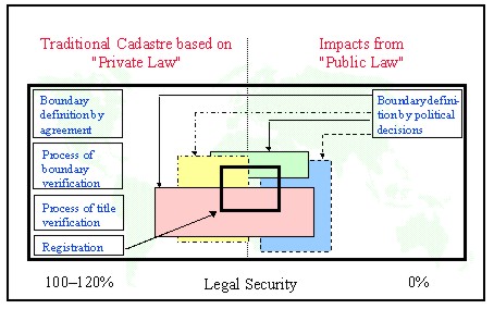
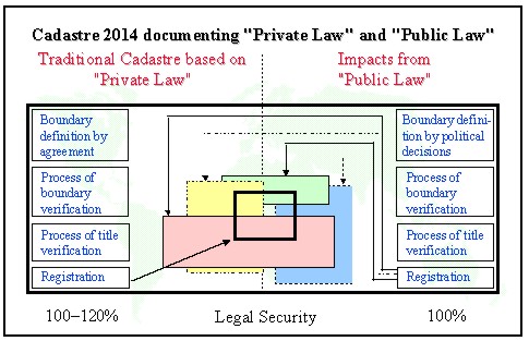
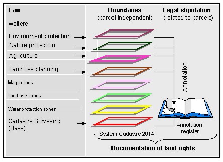
Figure 2. Definition for Cadastre 2014 This definition corresponds to the first six statements on Cadastre 2014 which states: Cadastre 2014 will show the complete legal situation of land including public rights and restrictions! Every piece of legislation concerning land matters defines legal land objects. All these land objects are to be carefully defined, verified, and kept in an official documentation accessible for the public. Otherwise the legal security important to governments and administrations, economies, private persons, and land owners will not be ensured. Lacking legal security leads to uncertainty, lack of confidence, disorder, and finally chaos. This means that citizens lose confidence in their country's institutions, the land market as an essential part of the economy ceases to function, business becomes weak, and the whole system can crash. We can see such effects in different regions of the world. We can characterize the actual situation as shown in figure 3. Future cadastres shall correct this dangerous situation by applying the principles of cadastral systems on all legal land objects. Figure 4 shows the effect of this. Legal security is improved significantly.
Figure 3. Lack of legal security because public law land objects are not officially documented
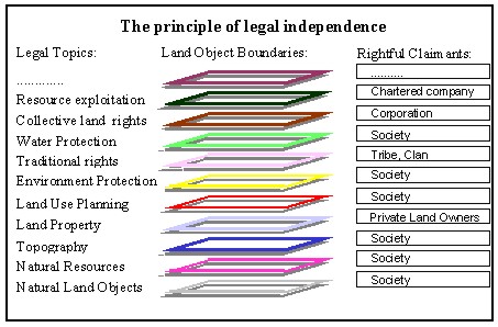
Figure 4. Improvement of legal security applying the principles of cadastre for public law land objects All legal land objects must be carefully delimited, verified, and registered. This future complete documentation of the legal situation of land must respect a certain structure. It must respect the principle of legal independence, which is shown in figure 5.
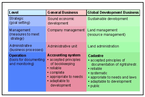
Figure 5. The principle of legal independence The different legal land objects are to be arranged according to the laws by which they are defined. This structure allows the immediate adaptation of the cadastre to the development of the legislation. It is not necessary to rearrange the information when a new law is implemented. New legal topics can be simply added. The second statement on Cadastre 2014 says: The separation between 'maps' and 'registers' will be abolished! The establishment of separate organizations for map production and land registration was often necessary because the two operations used to require different skills, and the available technology did not allow for other solutions. With information technology (IT) it is possible to link land objects directly with the information needed for registration. Land objects can be described in future by the geometric and the alphanumeric parameters, with the latter containing the legally relevant records. The still often practiced separation of the physical and organizational structure will become unnecessary. Statement three takes into consideration that modern information technology based cadastres will have a forceful impact on the way of working: 'Cadastral mapping' will be dead! Long live modelling! Information technology works with digital data and provides the ability to model objects of the real and legal world. Maps as analogue representations will lose their function as information storehouses; their only purpose will be to represent information in such a way that it can be communicated easier and in a more comprehensive form. In future we will have increasingly different graphic representations as extracts of the cadastral model tailored to the needs of the individual customer. To store maps as a picture on a computer is therefore an archaic operation. The fact that in future information technology will be used to operate cadastral systems is expressed by statement four: 'The paper and pencil cadastre' will be gone! As you can see from the terms of reference of the working group, the work concentrated on developed countries because one thought then, that in developing and transitional countries the traditional methods would be carried on. Today, six years later, one cannot find any cadastre project in the world where information technology is not involved. IT makes work easier. The trend to privatize at least the operational work to be executed in the field of cadastre is reflected in statement five: Cadastre 2014 will be highly privatized! Public and private sectors are working closely together! The privatization and new public management topic will affect the cadastre as it affects any other domain of human activity. This is a fundamental trend. The public domain will nevertheless have to provide for secure land titles but it will outsource most operational work and concentrate on supervision. Finally, in statement six the aspect of cost recovery which is also a potent trend is expressed: The cost of Cadastre 2014 will be recoverable! The awareness that even operations executed by the public sector have their price, and that the public and the private sectors have at least to cover their costs leads to efforts to implement cost covering fees also in cadastre. In several cadastral systems it was proved that cost recovery is possible. Because cadastre is a long-term investment the depreciation period for the initial investment costs can be longer than for normal goods. 2. REACTIONS OF THE SURVEYING COMMUNITYThe surveyor's reaction to the brochure was rather positive. A huge interest was shown all over the world. The brochure was translated into further languages such as Albanian, Bulgarian, Finnish, French, Georgian, German, Greek, Korean, Latvian, Macedonian, Polish, Russian, Serbian, Slovenian, Ukrainian. The Australian Institution of Surveyors, asked for the copyright and reprinted 5'000 copies to distribute them to all Australian and New Zealand surveyors. Several universities and other educational institutes have included Cadastre 2014 in their curricula. In several important events, Cadastre 2014 played an important role. Among others, it was taken into consideration during the "International Workshop on Land Tenure and Cadastral Infrastructures For Sustainable Development" in Bathurst, NSW, Australia and the resulting International Seminar in Melbourne in October 1999. Cadastre 2014 was shown there in its future role of a book-keeping system for land management and land administration to support sustainable development. The interest in the vision is still very strong and FIG's Annual Review 99 finds that 'similar best-seller status is predicted for Commission 7's companion publication on reforming the cadastre 'Cadastre 2014''. 3. THE FUTURE ROLE OF CADASTRE 2014 IN SUSTAINABLE DEVELOPMENT OF HUMANKINDThe world, its different cultures, and its political and economic systems are in a permanent development process. This process is driven primarily by the activity and the creativity of humankind. New medical and technical possibilities have impacts on life, on the way of living, and on the way of doing business. One effect of this development is the growth of the world's population. More and more people are to be provided with food and water, housing, household and transport equipment, energy, etc. An increasing number of people are demanding leisure activities and facilities. The demand for waste removal, water cleaning, and recycling materials is increasing. This development leads to an increase in the consumption of natural resources, particularly of land. It has been acknowledged that disorganized consumption of natural resources will lead to a degradation of nature, of the natural world, of the environment, and finally of humankind. Efforts are being made to encourage sustainable development. That means that development should be undertaken in such a way that a minimum of resources are consumed. It is the main goal of Agenda 21 to improve awareness of and introduce measures for a sustainable development of humankind in harmony with the environment. As land is an important part of nature and the environment is the basis for nutrition, housing, energy production, resource exploitation, leisure activities, waste disposal, economic activities - in short for the maintenance and survival of humankind - cadastres are a crucial aspect of sustainable development. Traditional cadastre systems, however, can no longer meet the high standards set by sustainable development. There is a need to adapt the currently successful operating cadastral systems to the new standards and to implement improved cadastral systems where no such infrastructure exists. This is one reason for the many ongoing cadastral reforms and efforts in the world. Unfortunately the changes are often not rigorous enough and a lot of human resources and financial means are invested with questionable results. To be able to use land and natural resources in a sustainable manner it is necessary that one can access a reliable bookkeeping system. The successful operation and development of a business is based on a well developed financial administration system. Alike the sustainable development of humankind must be supported by a complete land administration system. Like the financial administration system, the land management system must obey clearly defined rules that are valid world-wide in principle, and which are only adapted in detail to accommodate national and cultural peculiarities. Cadastral systems - as shown in figure 6- will in future provide this bookkeeping or accounting system being an important precondition for land administration and land management in favor of sustainable development. The principles of a cadastre are acknowledged world-wide. The details can be adapted to meet the needs and traditions of a particular country. Land management needs reliable information about the existing land and its resources and about the legal situation of these items. This information will be provided by future cadastral systems. Modern cadastres will be the most important part of the land administration systems that will support the world's hopes for sustainable development.
Figure 6. Cadastre 2014 in the framework of the land business 4. EXAMPLES FOR INITIATIVES TO MAKE THE VISION CADASTRE 2014 A REALITY4.1 Swiss Association of Licensed Surveyors (IGS)The Swiss society of Licensed Surveyors has launched in 1999 an initiative to promote Cadastre 2014. Several laws regulating spatially related subjects have been analyzed to find and model the respective legal land objects. These models, described in the data definition language INTERLIS, were implemented in land information systems as real world examples for Cadastre 2014. The results are discussed broadly with professionals, politicians and even bankers. Politicians and bankers understand well the role of Cadastre 2014 as a tool to obtain reliable, updated and complete information on the legal situation of land, which is a very important political and economic factor. In Switzerland US$270 billion are secured by mortgages. The initiative brings together the surveyors and the land registrars to provide better services to governments and citizens. 4.2 Reform of the physical law about land use planning in the Swiss Canton of ZürichIn the context of a completely redesigned law about land use planning in the Canton of Zürich, Cadastre 2014 is the tool to register all private and public rights and restrictions, to exchange this information between organizations interested in land matters, sustainable development and environmental protection. Cadastre 2014 also helps to resolve the sensitive questions of protection of data and individuals (Figure 7).
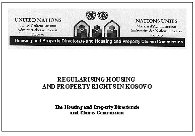
Figure 7. Concept of the documentations system for land rights and restrictions in the Swiss Canton of Zurich 4.3 The multipurpose cadastre in the Principality of LiechtensteinIn the Principality of Liechtenstein the new cadastral system is designed according to the visions of Cadastre 2014. The cadastral law declares every set of legal land objects to be part of the national spatial data infrastructure. The cadastre contains, besides the private property parcels, the encumbrances, the land use zones and the water, soil, landscape and noise protection zones, the rockfall, avalanche and landslide risk zones, the monument and building protection zones, the agricultural production zones, the civil protection and water, sewerage and energy infrastructures, etc. This information is shared by the state and municipal authorities, the citizens and the market. The private sector plays an important role and cost recovery has reached a high level. 4.4 The re-establishment of the cadastre in KosovoThe international project for the re-establishment of the cadastre in Kosovo is based on the ideas of Cadastre 2014. The traditional cadastre system containing the private land property records is partly missing and is to be reconstructed with the help existing maps and books in the archives. A big problem is the residential property where 100'000's of claims are expected. The modernized cadastre of Kosovo should be able to provide reliable information about the residential properties besides the information on land property. This information will be important for the Housing and Property Directorate and the Housing and property Claims Commission (Figure 8) to settle the disputes. Later on it is expected, that more reliable documented legal stipulations amongst others mined zones, areas where depleted uranium ammunition has been used, etc. must be included in the cadastre. The new Kosovo cadastre is therefore structured according to the rules of cadastre 2014 and a carefully defined data model in INTERLIS is an important component of the new solution.
Figure 8. Housing and Property regulation in Kosovo 4.5 The Belarus cadastral systemThe implementation of the private land property in Belarus demanded a new cadastre system. In view of the needs for reliable data on land, in particular in the zones where heavy environmental damages have been caused by the Chernobyl disaster on one hand and by industrial pollution on the other hand, the cadastre was designed to be able to document other land objects than only the private property parcels. Figure 9 shows the structure and contents of the Belarus spatial cadastre.
Figure 9. Application of Cadastre 2014 principles in the reformed Belarus space cadastre BIOGRAPHICAL NOTEJürg Kaufmann (born in 1942) is working in KAUFMANN CONSULTING, im Hauffeld, Switzerland. Education CONTACTJürg Kaufmann 18 April 2001 This page is maintained by the FIG Office. Last revised on 15-03-16. |