SPATIAL INFORMATION MANAGEMENT (SIM) FOR BERLIN URBAN TRANSPORT SYSTEMDr. Martin SCHEU and Detlef ROSENBAUM, GermanyKey words: Abstract
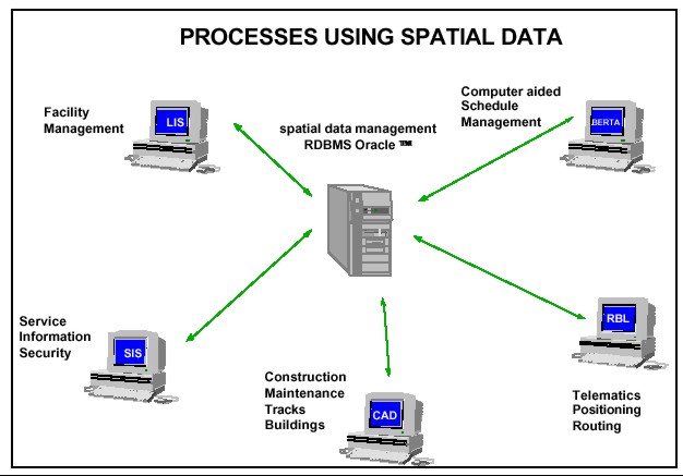
BVG - The Largest German Local Public Transport CompanyThe Berlin Transport Authority (BVG) is the largest municipal public transport system in Germany. The BVG transport system consists of underground lines, tram routes and bus routes. The BVG supports public transport for more than 3.4 Mio inhabitants in the area of Berlin and Brandenburg and spreads over 1,000 km². The customer-oriented company concept of the BVG concentrates on providing extensive service, cleanliness and safety. The 15,200 employees of the BVG endeavour every day to ensure that passengers arrive at their destinations on time and in a comfortable manner. BVG - Processes Using Spatial DataVarious BVG-processes generate certain spatial data, which are important for the entire company. One of the main tasks is the harmonisation of these different GIS-applications. Harmonising and combining different spatial data sources, supported by modern internet/intranet - technologies, offers process acceleration.
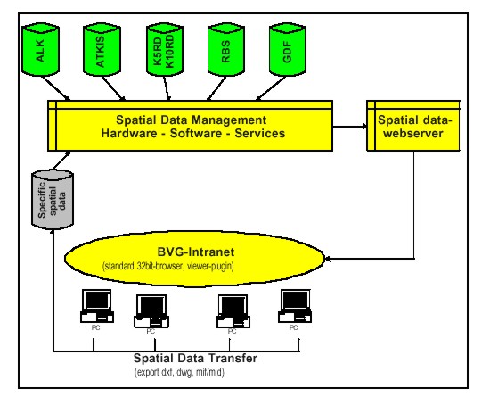
The BVG-GIS-project started in 1997 analysing all existing GIS-applications and data sources. Since 1998 first implementation steps using relational database (RDBMS) and web technologies have been carried out. BVG SIM StrategyThe BVG IT-network includes nearly 3000 PC-clients. A company intranet supporting WWW-services has already been established. Using this existing IT-infrastructure, investment for GIS-implementation and data distribution will be minimised. Also costs for training and information distribution are reduced because BVG staff are used to intranet-applications.
ConclusionsBVG GIS implementation is divided into three steps. Establishing of intranet GIS and basic data distribution is finished. Integration of specific data takes place in different departments. One of the main tasks for the future is to ensure the topicality of spatial data. CONTACTDr.-Ing. Martin Scheu Dipl.-Ing (FH) Detlef Rosenbaum 24 March 2001 This page is maintained by the FIG Office. Last revised on 15-03-16. |