ESRI International User Conference 2004
San Diego 7-13 August 2004
2nd Survey Summit was a Big Success - FIG Receives Special Achievement
Award in GIS
 The
24th ESRI International User Conference gathered more than 13,000
participants to San Diego, California, USA from 9 to 13 August 2004. In the
programme there were both plenary sessions, technical sessions on case
studies, development of the software but also of more political issues on
the use of GIS. The theme of this year's conference was "GIS - the
language of geography". The main keynote presentations were given by Jack Dangermond, President of ESRI and Dr.
Rita R. Colwell, one
of the leading experts in global infectious diseases. ESRI is one of the
corporate members of FIG. The
24th ESRI International User Conference gathered more than 13,000
participants to San Diego, California, USA from 9 to 13 August 2004. In the
programme there were both plenary sessions, technical sessions on case
studies, development of the software but also of more political issues on
the use of GIS. The theme of this year's conference was "GIS - the
language of geography". The main keynote presentations were given by Jack Dangermond, President of ESRI and Dr.
Rita R. Colwell, one
of the leading experts in global infectious diseases. ESRI is one of the
corporate members of FIG.
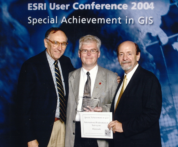
 One
of this year's awards "Special Achievement in GIS" was given to FIG
for bridging the gap between surveying and GIS. In the written explanation
FIG was awarded because it "has worked diligently in cooperation with
ESRI to help Bridge The Gap between surveying and GIS professionals. FIG
supported and sponsored the inaugural Survey & GIS Summit in 2003. In
addition, FIG Commissions 2, 3, 7, 8, and 10 involve the direct relationship
between surveying and GIS. FIG and ESRI established a grant program that
provided software, valued at over $15.6 million, to 49 universities
worldwide. The goal of ESRI and FIG Grant Program was to foster and support
the integration of GIS technology in engineering and surveying colleges and
universities worldwide - particularly in the developing world. The program
was established to assist colleges and universities in teaching students the
latest in technologies for surveying and engineering applications.
University software licenses and technical support were granted to 17
universities in the United States and 32 universities from the following
countries: Costa Rica, Jamaica, Trinidad and Tobago, India, Mongolia,
Pakistan, Sri Lanka, Uzbekistan, Botswana, Cameroon, Czech Republic,
Colombia, Egypt, Ghana, Fiji Islands, Kenya, Lithuania, Nicaragua,
Philippines, Poland, Romania, Turkey, Ukraine, Zambia and Zimbabwe. FIG also
supports education and development through the FIG Foundation. The goal of
the FIG Foundation is to help build a sustainable future, especially in
developing countries, through grants and scholarships in support of
curricula development, research activities, and distance learning. A major
component of this is in GIS." One
of this year's awards "Special Achievement in GIS" was given to FIG
for bridging the gap between surveying and GIS. In the written explanation
FIG was awarded because it "has worked diligently in cooperation with
ESRI to help Bridge The Gap between surveying and GIS professionals. FIG
supported and sponsored the inaugural Survey & GIS Summit in 2003. In
addition, FIG Commissions 2, 3, 7, 8, and 10 involve the direct relationship
between surveying and GIS. FIG and ESRI established a grant program that
provided software, valued at over $15.6 million, to 49 universities
worldwide. The goal of ESRI and FIG Grant Program was to foster and support
the integration of GIS technology in engineering and surveying colleges and
universities worldwide - particularly in the developing world. The program
was established to assist colleges and universities in teaching students the
latest in technologies for surveying and engineering applications.
University software licenses and technical support were granted to 17
universities in the United States and 32 universities from the following
countries: Costa Rica, Jamaica, Trinidad and Tobago, India, Mongolia,
Pakistan, Sri Lanka, Uzbekistan, Botswana, Cameroon, Czech Republic,
Colombia, Egypt, Ghana, Fiji Islands, Kenya, Lithuania, Nicaragua,
Philippines, Poland, Romania, Turkey, Ukraine, Zambia and Zimbabwe. FIG also
supports education and development through the FIG Foundation. The goal of
the FIG Foundation is to help build a sustainable future, especially in
developing countries, through grants and scholarships in support of
curricula development, research activities, and distance learning. A major
component of this is in GIS."
FIG attended the User Conference in the exhibition together with ACSM,
FIG member association in the United States. The main reason for FIG
participation in San Diego was, however, the Survey and GIS Summit 2004 -
Bridging the Gap, which was held for the second time. FIG was one of the
partners of ESRI in organising this event. More than 450 participants from
26 countries attended this year - increase of more than 150 from the
first meeting last year. In the Summit programme the keynote was given by Charles Challstrom, Director, National Geodetic Survey (NGS), National
Oceanic and Atmospheric Administration (NOAA). Charlie is also a former Vice
President of FIG. The two-day programme offered several presentations that
described the need to bridge the gap between surveying and GIS and also ways
how to proceed on this way. The enthusiasm of the participants is promising
good for the future of these summits. After the two-day separate seminars
the participants were able to attend the ESRI User Conference were the
survey/GIS had its own track in the programme.
Several FIG member associations attended the Summit and User Conference
including participants from e.g. Colombia, Cyprus, Germany, Ghana, Spain,
Serbia etc. Read more about the Survey and GIS Summit at:
www.esri.com/events/survey/index.html |