The theme for FIG Congress 2022 will be:
This overall theme is addressing two aspects. The first part “Volunteering for the future” is the overall motto for the current term of Office from 2019 to 2022.
It reflects the urgent need for volunteers and volunteers’ work. And this need is not only specific for a federation like FIG. During the last decades, it became more and more difficult to convince people to do volunteered work for example for the local football club, the quire or a professional organisation like FIG. It reflects the urgent need for volunteers and volunteers’ work and the understanding for and impact on the tasks that are undertaken by International Professional Organisations like FIG.
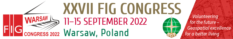
The second aspect is underlining the significant change in our profession. Decades ago, the standard product of a land surveyor was a topographic map or a cadastral plan. Typically, this product was only partly accessible and often reserved for military and state administration purposes only. This has changed radically. Today geo-information and all related products are seen in a much broader context and as public goods and beneficial for the well-being and betterment of the entire society. In addition to this, we can observe that the current geo-data-products are gaining in quality and are becoming more and more available free of charge for the user.
The overall theme Volunteering for the future – Geospatial excellence for a better living, is built up by the following sub-themes:
 |
The expression “Surveyor” is here used as a generic term comprising all occupations and professions in conjunction with Geospatial data. Among others are land surveyors, quantity surveyors, construction surveyors, cadastral surveyors, mining surveyors, photogrammetrists, topographers, cartographers, hydrographers, valuers, geo-informaticians, land and town planners. |
The technologists say that we are at the beginning or even in the middle of the 4th industrial revolution. And our profession is of course affected or in a positive wording profiting from these latest developments like Internet of Things (IoT) or Artificial Intelligence (AI). The numbering “4.0” wants to remind us here of this strong connection between the technical advancements in general and our geospatial activities. Surveyors have always been strongly associated with the most modern ways of presenting data, so they fit perfectly into the IoT and AI. Development of sensors lead us to more detailed and accurate measurements providing Surveyor innovative tools and methods. Automation in workflow that we deal every day allow us to work more effective and be competitive. Are we able to use this potential in connection with other fields of science and engineering to continue to stay on the top of technology?
COVID 19 changed the global live radically on at all levels. It changed our personal and private life, but also our professional customs and activities.
 |
The pandemic created new limitations but at the same time it offered also new opportunities. It would be wonderful to share during the Congress the new experiences and approaches related to digitalization, automation in professional work, teamwork, customer relations and document certification. Each crisis brings new opportunities… |
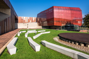
Open Data and Open Access are promoted by industry and politics not only in our professional field.
 |
What are the aspects, consequences, benefits and disadvantages of this approach? On the other hand, the verification of data in repositories is fundamental for sharing reliable data for making decisions. Does authoritative data in repositories compete to open access? Should they be Open Access. How we should deal with crowdsourcing being the opportunity to involve society in geospatial data collection and how it can be useful for surveyors. |
 |
Today we do not only measure and “deliver” a map as the final product. Together with other disciplines new geospatial products which are often of a multi-purpose-use are designed and developed according to the specific needs of the potential users. What is our role in improving not only the methods of sharing geodata, but also in specialized obtaining them in terms of other disciplines? |
How to convince our partners from other disciplines that despite progress and automation of measurement techniques with tools and methods available for everyone, they still should need surveyor?
 #FIG2022 |