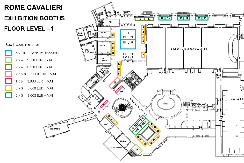
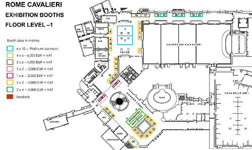
Exhibition and exhibitors
Exhibition
Sponsors
| Platinum
Sponsors |
 |
 |
 |
|
Silver Sponsor |
 |
 |
|
|
Pads and Pens Sponsor |
|
|
 |
|
|
FIG Foundation Dinner Sponsors |
|
|
|
|
|
Institutional partners |
 |
 |
 |
|
Media partners |
 |
 |
 |
List of exhibitors
Exhibitor Descriptions
|
PLATINUM SPONSOR
FIG 2012 |
Esri Esri’s
geographic Information system (GIS) technology has given clients
the power to think and plan geographically for over 40 years.
Used today in more than 350,000 organizations worldwide, GIS
helps cities, governments, universities, and Fortune 500
companies save money, lives, and our environment. GIS helps you
understand and question data in ways that reveal relationships,
patterns, and trends. So whether you are transporting ethanol or
studying landslides, you can use GIS to solve problems and make
better decisions, because a GIS enables you to look at your
valuable data in a way that is quickly understood and easily
shared. ESRI supports the implementation of GIS technology on
the desktop, servers, online services, and mobile devices.
Contact: Joe Johnson:
joe_johnson@esri.com |

PLATINUM SPONSOR
FIG 2012 |
Trimble Navigation
Trimble transforms the way work is done through the
application of innovative positioning. By integrating a wide
range of positioning technologies such as GPS, laser, optical
and inertial with application software, wireless communications
and services, Trimble provides complete solutions that are
focused on applications requiring position or location –
including surveying, construction, mining, agriculture,
utilities, public safety, asset management and mapping. Trimble
solutions are used in over 100 countries around the world. Our
portfolio includes over 900 patents and serves as the basis for
the broadest positioning offerings in the industry. With
employees in more than 21 countries and a highly capable network
of distribution partners, Trimble customers are served and
supported with world-class training, support and service
capabilities. Visit our booth to see the latest Trimble
positioning solutions including surveying, mapping, GNSS
infrastructure network, photogrammetry and LIDAR. Find out how
Trimble’s unique positioning solutions can help you increase
your productivity and grow your business!
Contact: Keith Hofgartner:
keith_hofgartner@trimble.com and Christiane Gagel:
Christiane_Gagel@Trimble.com
|
|
 |
CAM2 srl FARO
develops and manufactures portable systems for the measurement
and 3D documentation of spaces and objects. Products from FARO
permit rapid and highly precise 3D measurement for inspection,
quality control, alignment, surface modeling, asset management,
and documentation needs. The simple-to-use solutions are ideal
for numerous applications in various industries, including
manufacturing, automotive, aerospace, architecture and civil
engineering, energy and forensics. FARO currently has more than
26,000 installations and 13,000 customers globally.
Principal products include the world’s best-selling portable
measurement arm – the FaroArm®, FARO® ScanArm, the FARO® Gage,
the FARO® Laser Tracker, the FARO® Laser Scanner, the FARO® 3D
Imager and the CAM2 family of advanced CAD-based measurement and
reporting software. FARO is ISO-9001 certified and ISO-17025
laboratory registered. For additional information, visit
www.faro.com .
Contact: Alberto Castiglioni, Regional Marketing Manager,
Italy:
Alberto.Castiglioni@faroeurope.com |
|
SILVER SPONSOR
FIG 2012 |
Marsh & McLennan Companies
Marsh, a global leader in insurance broking and risk management,
teams with its clients to define, design, and deliver innovative
industry-specific solutions that help them protect their future
and thrive. It has approximately 25,000 colleagues who
collaborate to provide advice and transactional capabilities to
clients in over 100 countries. Marsh is a wholly owned
subsidiary of Marsh & McLennan Companies (NYSE: MMC), a global
team of professional services companies offering clients advice
and solutions in the areas of risk, strategy and human capital.
With 52,000 employees worldwide and annual revenue exceeding $10
billion, Marsh & McLennan Companies is also the parent company
of Guy Carpenter, a global leader in providing risk and
reinsurance intermediary services; Mercer, a global leader in
human resource consulting and related services; and Oliver Wyman,
a global leader in management consulting. Follow Marsh on
Twitter @Marsh_Inc. |
|
 |
Shanghai HuaCe Navigation
Technology Ltd. (or CHC)
CHC designs, manufactures and markets a wide range of
professional GPS/GNSS solutions in various markets such as land
surveying, civil engineering, utilities, deformation monitoring...
Headquartered in Shanghai (China). CHC is a leading GPS/GNSS
Chinese manufacturer with a strong international presence and
employs about 500 people worldwide.
Contact: Mao Xunye:
mao@chcnav.com |
|
 |
KQ GEO Technologies Co.,
Ltd.
Contact: Maggie Wang:
maggie.wang@kanq.com.cn
|
|
 |
FIG Nigeria 2013
FIG Working Week 2013 will be held in Abuja Nigeria 6-10 May
2013.
Contact: FIG Office: fig@fig.net
|
|
 |
Faynot
The FENO Marker range offers accessories facilitating the
work of the chartered surveyor: survey spikes, nails and stakes,
building site markers and identity disks to be signed by a
surveyor or a public authority. In addition to these, it offers
more complex markers for road work and railway installations.
Contact: Laura di Cesare:
laura.di-cesare@faynot.com
and Arnaud Dechateau:
arnaud.dechateau@faynot.com
and Emilie Dupont:
emilie.dupont@faynot.com |
|
 |
Omnitech
Omnitech ranks among the experienced and leading companies
comprising Israel's Computer and Technology Market. The Company,
founded in 1979, is part of the Malam Team Group, stands out in
its ability to respond to the multihued range of technological
demands and to supply preferred technology solutions to
organizations of all sizes and to all sectors of activity.
Omnitech, is the solely Israeli representative for the broadest
portfolio of software solutions' of Autodesk, Inc. the world
leader in 2D and 3D design software for the manufacturing,
engineering, and design markets enabling its customers to work
with the most innovative, professional tools and achieve
competitive advantage while meeting their business goals.
Contact: Einat Neeman:
einatn@omnitech.co.il |
|
 |
Leica Geosystems
With close to 200 years of experience pioneering solutions to
measure the world, Leica Geosystems products and services are
trusted by professionals worldwide to help them capture,
analyze, and present spatial information. Leica Geosystems is
best known for its broad array of products that capture
accurately, model quickly, analyze easily, and visualize and
present spatial information.
Those who use Leica products every day trust them for their
dependability, the value they deliver, and the superior customer
support. Based in Heerbrugg, Switzerland, Leica Geosystems is a
global company with tens of thousands of customers supported by
more than 3,500 employees in 28 countries and hundreds of
partners located in more than 120 countries around the world.
Leica Geosystems is part of the Hexagon Group, Sweden.
Contact:
surveying@leica-geosystems.it
http://www.leica-geosystems.it |
|
 |
THOMSON REUTERS
Thomson Reuters is the world's leading source of intelligent
information for governments, businesses, and professionals,
combining industry expertise with innovative technology to
deliver critical information to decision makers. Our integrated
Government Revenue Management (GRM) suite offers clients an
end-to-end solution for efficient and equitable land and
property tax administration. OpenTitle™ is our entry-level
registry/cadastral solution that is quick to deploy and easy to
use allowing for the rapid collection and secure management of
land rights information be it informal, communal or statutory.
Contact: Megan E. Wierenga:
Megan.Wierenga@Manatron.com |
|
 |
International Federation of
Surveyors - FIG Contact: FIG Office:
fig@fig.net |
|
 |
New Zealand Institute of Surveyors
NIZS is bidding to host the FIG Working Week 2016 in New
Zealand.
Contact: Kurt Bowen:
kurtbowen@surveyors.org.nz |
| |
Exhibition of old instruments by CNGeGL |
|
 |
South Survey
Established in 1989 and headquartered in Guangzhou, South
Surveying & Mapping Instrument Co., Ltd. is a professional and
leading enterprise in the surveying industry inMainland China,
whose five affiliated factories specialize in R&D and
manufacturing and selling nine kinds of surveying products,
including Total Station, Electronic Theodolite, Electronic
Distance Meter, Automatic Level,
Laser Level, Reflector Prisms, surveying accessories, GPS
receivers, Mapping Software, etc.
Contact: Stoneash:
export@southsurvey.com |
|


 |
CNGeGL
GeoWeb S.p.A.
Cassa Italiana di Previdenza e Assistenza Geometr
Contact: Maria Scorza:
m.scorza@cng.it |
|
|
8th FIG Regional Conference - Montevideo, Uruguay 2012 |
|
 |
FIG Congress 2014 - Kuala Lumpur, Malaysia |
|
|
Silver sponsor Aruba, is an Italian company born in
1994, where nowadays over 440 people work. It operates through 8
main brands. The main offices and datacenters are spread all
over Italy, Czech Republic, Poland, Hungary and France. The head
office is located in Bibbiena (Arezzo - Italy).
Aruba is the 1st provider in Italy , Czech Republic and Slovak
Republic for number of websites in hosting and for number of
registered domains. It is on the top 5 in Europe and on the top
10 in the world for No. of domains and active websites. Aruba
hosts in Italy over the 50% of websites, certificied domains and
PEC accounts.
Datacenters cover an area of over 10.000 sq.m within over 14.000
server managed.
Over 2 million customers choose Aruba services such as: Domain
registration, Hosting, E-mail, Data Center services, dedicated
servers, virtual servers and Cloud services, Saas, solution and
managed applications, certified e-mail (PEC), connectivity
services, Digital signature, E-security services, OTP, token,
PKI, Digital printing.
Advertising and web marketing is developped and distributed by
Aruba Media Marketing .
Aruba is focused as well on Production and Customisation of
Smart cards, CRS/TS, supply planning and management of IT
infrastructures in full outsourcing .
Contact: Mirco Marsili:
mirco.marsili@staff.aruba.it |
|
|
Pads and pens sponsor
Korea Cadastral Survey
Corporation
Korea Cadastral Survey Corporation (KCSC) was established in
1977 and is a public organization, conducting cadastral survey
and providing cadastral information service, under controlled by
the Ministry of Land, Transport and Maritime Affairs.
KCSC retains 3,700 highly qualified and competence staffs who
are cadastral expert, geodesists, photogrammetrists, urban
planner, and administrative consultants. In addition KCSC equips
advanced technology such as aerial photogrammetry, LiDAR system
and Network-based GPS to lead national geospatial information
industry. The organization has 1 headquarter, 12 branch offices
and 185 local offices. There are two more institutes associated
with KCSC. One of them is the Cadastral Training Institute for
Re-education & Training for cadastral surveyors and public
officers. And the other is the Spatial Information Research
Institute which is responsible for doing research on
institutional and technical issues.
KCSC is an official partner of the Korea International
Cooperation Agency (KOICA). Since 2006 KCSC has been engaged in
overseas projects in various parts of the world using Official
Development Assistance (ODA) funds.
KCSC’s vision is to assist developing countries through transfer
our technology as well as contribute to promotion of national
geospatial information industry.
Contact: Jong Hyun Yoon:
yunjh@kcsc.or.kr |
|