Enhancing Professional Competence of Surveyors in EuropeStig Enemark and Paddy Prendergast (Ed.)
|
||||||||||||||||||||||||||||||||||||||||||||||||||||||||||||||||||||||||||||||||||||||||||||||||||||||||||||||||||||||||||||||||||||||||||||||||||||||||||||
ContentsPaddy Prendergast Stig Enemark Rob Ledger Hans Mattsson Frances Plimmer Appendices B Table of Academic Courses producing Geodetic Surveyors in Europe C Educational Profiles at Universities Investigated D FIG Definition of "Surveyor" E Questionnaire on Threshold Standards for Professional Competence F Programme of the Joint CLGE /FIG Seminar in Delft University of Technology on 3rd November 2000 Executive SummaryStig Enemark and Paddy PrendergastIntroductionThe International Federation of Surveyors (FIG) established a Task Force on mutual recognition of qualifications/reciprocity in 1997, in order to investigate the concept of 'standards of global professional competence' for surveyors. FIG recognised the need due to international market pressures and the introduction by the World Trade Organisation (WTO) of regulations to liberalise trade in services. The intention is to review the area of mutual recognition of qualifications within the world-wide surveying community and develop a framework for introduction of standards of global professional competence in this area. It is FIG's aim to drive these developments instead of being driven by them, and the work of the task force was seen only as the first step in this direction. FIG will launch a final report including a policy statement on Mutual Recognition at the FIG Congress in Washington, April 2002. In parallel to the FIG initiative the Council of European Geodetic Surveyors (CLGE) established a working party to develop a 'core syllabus' for geodetic surveying early in 1998. The concept was to try to identify a core syllabus detailing the technical subjects and levels, which should be common in all academic courses producing geodetic surveyors. The intention for the report on the core syllabus was to provide:
These two objectives were ultimately about enhancing professional competence of surveyors. The European models in this area were examined through some research grants awarded by CLGE during 2000. Furthermore, it was seen as an ideal issue for merging the efforts of CLGE and FIG. The objectives were dealt with at a joint CLGE/FIG seminar held at Delft University of Technology in November 2000. This was a significant event since this was the first time that CLGE and FIG have formally collaborated on a project. We hope that this will be setting a precedent for the future. BackgroundThe rights of EU citizens to provide services anywhere in the EU are fundamental principles of EU law. National regulations, which only recognise professional qualifications of a particular jurisdiction present obstacles to these fundamental rights. These obstacles are overcome by rules guaranteeing the mutual recognition of professional qualifications between Member States, i.e. the Sectoral and General Directives. The Sectoral Directives deal with specific regulated professions (physicians and specialists, general nurses, dentists, midwives, veterinarians, pharmacists, and architects). The General Directives introduced in 1989 and 1992 deal with qualifications obtained through programmes of higher education (89/48/EEC), and with qualifications obtained through secondary vocational education and short programmes of higher education (92/51/EEC). The European Commission carried out a review of these Directives during 2000 due to a perception that little progress has been made implementing procedures for mutual recognition of qualifications since they were introduced. Consequently, it was opportune that FIG and CLGE were jointly investigating the issue from the surveying perspective at the same time. Traditionally, the regulated portion of the surveying profession predominantly operated in niche markets, which were either local or national in character. These regulated markets are not conducive to mobility of professionals, due to the wide variety of procedures, laws, and functions performed by surveyors. However, the non-regulated portion of the surveying market is highly conducive to mobility, and has been quite successful with mobility of personnel during the last decade. Seminar in DelftA joint CLGE / FIG seminar on Enhancing Professional Competence was held on 3rd November 2000 at Technical University in Delft in the Netherlands. Initial results from the following research projects were presented:
The intention of the seminar was to widen the debate among the academic surveying community in Europe and to provide an opportunity to include their opinions and ideas. The seminar was by invitation only and attracted some 50 participants from 17 countries representing the educational sector and the professional surveying community in Europe. The seminar was very successful and has generated many articles in national surveying journals in Europe. We now hope that the final results of the research projects contained within this report will stimulate further discussion on this important subject. We do not consider the seminar or this report to be the final answer, but only the beginning of a process to investigate and debate these issues more widely, and to provide us with the knowledge to allow us choose good policies for the future of our profession. It is anticipated that the outcome of this report will then form the basis for the development of a world-wide model by FIG. ConclusionsIt seems evident from the debate in the seminar that "the only constant is change" and that we must continue to ensure that our graduates are educated for a changing profession in a changing market. It is important to provide future surveyors with the necessary professional education and training and the administrative procedures to work anywhere in Europe. While our marketplace is, currently Europe, there is a clear indication from the World Trade Organisation that the marketplace will soon be global. There was a clear indication of a future educational profile composed by the areas of Measurement Science and Land Administration and supported by and embedded in a broad interdisciplinary paradigm of Geographic Information Management. There was also a clear indication that a better understanding of different educational and competence models can establish a general improvement of the educational base and enhancement of professional competence in the broad surveying discipline throughout Europe, and also on a more global scale. The primary objective of the Bologna Agreement was to establish and promote the European system of higher education world-wide. This will only be successful if the basic underlying principles for education promoted in Europe are of a sufficiently high standard. There is a danger that the BAC + 3 threshold is too low as a basic professional qualification and that the quality of existing professional qualifications in Europe will be eroded, thus hindering the overall objective of the European Ministers of Education. One way of predicting future needs is by observing the development of the profession, so that decisive changes can be discovered at an early stage and distinguished from more transitory events. Another way of broadening the basis of assessment is by considering developments in other countries, in both education and practice. Given the internationalisation, which has taken place, not least in Europe, there is every possibility of both professional and university representatives actively sharing one another's experiences. The so-called "Allan Report" published by CLGE, has shown how complex reality is, but also how eventful. Presumably our concern should be with encouraging educational and professional dynamism rather than with isolating certain activities. There are a number of barriers, which hinder mutual recognition in Europe. Language, national customs and cultures are, however, not true barriers to mutual recognition and the free movement of professionals which mutual recognition is designed to achieve. Lack of knowledge and fear are the main barriers and yet with improved communication and understanding, these will disappear. We should concentrate, not on the process of becoming a qualified surveyor, but on the outcomes of that process. Mutual recognition, either as a profession world-wide or on a more selective reciprocity basis, becomes simply an issue of investigating the competence of qualified individuals to perform the surveying tasks undertaken in other countries. Inevitably, one of the essentials to achieving the free movement of professionals is the recognition and acceptance by our clients of our particular skills. This can not be dealt with through "internal" restructuring. It is more of a promotional exercise, and it is basically about enhancement of professional competence. RecommendationsIt is recommended that
CLGE's Initiative to Enhance Academic Standards for Geodetic Surveyors in EuropePaddy PrendergastAbstractThe diversity of course content and standards achieved in the academic courses producing European geodetic surveyors leads to differences in the range and types of services provided by the profession throughout Europe. The intensive application of technology within surveying during the last 30 years has automated many highly technical procedures. The trend towards liberalisation of national surveying markets, and the development of new international markets due to the EU's internal market policies and the advance of globalisation has demanded new skills of surveyors. All of these factors combined to identify education as the key issue for the future of the surveying profession during a re-evaluation of CLGE's aims during 1999. BackgroundCLGE, (Comité de Liaison des Géomètres Européens, or the Council of European Geodetic Surveyors in English) is the umbrella organisation for national professional associations of geodetic surveyors in Europe. CLGE represents approximately 25000 surveyors in 21 European countries. The term geodetic surveyor is used by CLGE as a collective term to include land surveyors, surveying engineers and géomètres-experts throughout Europe. IntroductionOne of the most obvious traits of the surveying profession in Europe is its market diversity in the different countries. Professional services provided by geodetic surveyors in one EU country may be provided by other professionals in another country. This wide diversity of professional practice has led to a corresponding diversity in academic qualifications for geodetic surveyors. Academic programmes are also primarily focussed on each country's own national surveying marketplace, which puts different emphases on some aspects and includes other areas of study not common to all countries or in all curriculums. This diversity was identified in the early 1980's by CLGE, and an attempt was made to document the range of activities of each national system in a report entitled 'The Education and Practice of the Geodetic Surveyor in Western Europe'. The first edition was published in 1985, and two further editions have since been published. This report, now commonly referred to as the Allan Report after its editor Prof. Arthur Allan of University College London, is very comprehensive, provides information in a standardised format, and includes three charts explaining the situation in each country. The first chart documents the route(s) available for qualifying as a geodetic surveyor. The second lists the academic subjects and their relative amounts completed during the third level academic qualification. The third chart lists the disciplines practised by surveying professionals during their careers. In my view, the report highlights the differences between the countries rather than identifying and analysing similarities. Core SyllabusCLGE established a working party in early 1998 to focus on bridging some of these differences. If geodetic surveyors from the different parts of Europe were ever to be treated as equals by one another and by other professions then we had to try to initiate change in the academic courses producing geodetic surveyors. The initial concept was to try to identify a core syllabus, which detailed the technical subjects and levels, which should be common in all academic courses producing geodetic surveyors. It was also intended that the core syllabus should be flexible enough to permit inclusion of subjects of national importance, such as national property law. I wish to stress that this initiative was not an attempt to harmonise curriculums in Europe. Cultural diversity is one of Europe's strengths, and it was not intended by CLGE for the core syllabus to limit this in any way. The concept was to try to bring diverging curriculum development into parallel streams, rather than try to force them to converge on one common core curriculum. What was needed were some guiding policies or principles to provide a framework for curriculum development. It was also expressly stated that the core syllabus should not represent a minimum standard from the range of existing courses. The concept was to define a high standard to which countries could develop and enhance their existing courses. A main objective of this initiative was to supply information to improve our understanding which would in turn initiate change of national surveying curriculum's and enhance academic standards within Europe. Different Models ExaminedDifferent models were examined by the working party to identify how a core syllabus might be implemented. The accreditation model used by the International Hydrographic Organisation (IHO) and Commission 4 of FIG was investigated initially. A syllabus is specified jointly by the IHO and FIG Commission 4, which academic courses around the world adopt voluntarily in order to acquire IHO accreditation. Academic institutions are then visited on a five-year basis to accredit the curriculum being delivered versus the published syllabus, which is modified regularly to embrace new technologies and methods. CLGE decided not adopt this model at this stage, because although the practice of hydrography internationally operates under a common international maritime law, the same could not be said for the different countries of Europe where different legal systems and standards apply. Two other difficulties with this model were that a) curricula are set by national or state administrations in some European countries, which might not readily accept the accreditation concept, and b) CLGE does not currently have the resources to operate such a model. CLGE may need to re-examine this model in the future. Another model examined was the ISO/TC211/PT 19122 proposal to establish an ISO standard for the Qualification and Certification of Personnel for Geographic Information/Geomatics. This model was considered too rigid in that a content definition for an academic qualification would prove to be too difficult to modify once adopted as an ISO standard. The working party felt that curricula should be constantly amended to match the dynamic nature of the surveying market. "The idea that there is one best way of doing things that will last through time is ludicrous, especially in an environment that is changing so rapidly" (Dale, 2000). Secondly, the ISO proposal focuses specifically on geographic information management, which links the measurement science and land management areas of our profession. The effect of the ISO proposal would be to fragment the surveying profession by carving out the emerging central area of surveying practice for a new profession. This proposal was considered both undesirable and unworkable in practice. The model adopted by CLGE was to produce a core syllabus as guidance for directors of academic courses producing geodetic surveyors. There should not be any coercion in the implementation of this guidance. The core syllabus was to be a consensus supported by the majority of the national associations of CLGE, and as such would carry a certain weight. CLGE did not wish to encroach upon the academic independence of course directors, who are already well informed of national requirements. However, CLGE hoped to provide some advice and guidance on requirements at international level in Europe. Difficulties in developing a core syllabus began with an examination of whether courses should be assessed on input (i.e. the specific subjects and time devoted to them within the syllabus) or on output (i.e. the range of skills achieved by the graduate). There was a difference of opinion between the working party members on this issue. Some held the view that courses should only be assessed on the competence of graduates produced, while others held the view that the input system had the added benefit of supplying much needed basic guidance to course directors, especially for countries which needed assistance to develop their curricula. Research GrantsCLGE decided in Copenhagen in April 2000 to provide research grants to investigate both of these issues, and eminent European academics were chosen to conduct the research. Dr Frances Plimmer, University of Glamorgan in Wales was contracted to develop threshold standards and a methodology to assess the competence of surveying professionals. Prof. Hans Mattsson, Royal Institute of Technology, Stockholm in Sweden was contracted to examine the different models used in Europe for surveying courses with respect to curricula content and curricula delivery. Finally, Rob Ledger, Royal Institute of Chartered Surveyors in the United Kingdom who was the leader of the CLGE working party investigating the concept of a core syllabus was contracted to complete the definition of the core syllabus. All three presented interim results of their research to the joint CLGE / FIG seminar at Delft University of Technology in the Netherlands on 3rd November 2000, and ideas and feedback from the floor were collected. This joint report presents the final results of the research conducted under all three strands. Education Identified as KeyEducation was identified as the key issue for the future of the profession during a Re-evaluation of CLGE's Aims during 1999. One main reason why education was singled out was to provide geodetic surveyors with the skills and abilities necessary to allow them to adapt to the rapidly changing commercial environment in Europe. Traditionally, the surveying profession predominantly operated in niche markets, which were either local or national in character. Consequently, academic courses in different countries were adapted specifically for these local and national requirements without any reference to the needs of the international markets in Europe or globally. The EU have been developing a new international market in Europe via its internal market policies, and many central and eastern European countries have been progressively implementing market economies during the last decade. A wider international market at global level has also been rapidly developing recently, and regulations for these international markets in services are currently being negotiated in the GATS negotiations at the WTO in Geneva. The perceived effect of these negotiations is the opening of international markets outside Europe at the cost of increased liberalisation of the national markets within the EU, whereas in truth they are laying the regulatory framework for conducting international business in services. Enhancing the professional competence of surveyors is now urgently required to provide the skills necessary to exploit these new opportunities, and to optimise the effects of legislative reform at national and European level. All of these developments indicate that there is now an urgent requirement to refocus academic programmes producing geodetic surveyors on the needs of international markets as well as the traditional local and national markets. A second reason why education was identified as the key issue for the future of the profession is the intensive application of technology within surveying during the last few decades. New skills are required to exploit new data sources and make use of new methods, not only in an efficient manner, but also to ensure that the consequences of particular choices or actions are fully appreciated. "We should not thrust the black box, we should know what it is doing". The nature of our surveying business is changing and new opportunities are developing, such as in geographic information management, but other professionals are competing with us for these new opportunities. Surveyors have to prove their merit to maintain their foothold in these emerging areas, and they will need new skills to assist them. Many new projects are designed and managed by multi-disciplinary teams of professionals for which surveyors need equality of qualifications and management skills to allow them to participate effectively as equals. Curriculum changes, which are focussed and well designed, can provide these skills. These were two of the main reasons why education was identified as a critical issue for the future of the profession. The concept of a core syllabus was to deliver advice for course directors in identifying the skills required from the wider international perspective, and then provide guidance on a model curriculum to supply those skills. Mobility of ProfessionalsA secondary aim of the core syllabus initiative was to facilitate the mobility of professionals between European countries using the EU concept of mutual recognition of qualifications. The rights of EU citizens to provide services anywhere in the EU are fundamental principles of EU law. National regulations, which only recognise professional qualifications of a particular jurisdiction present obstacles to these fundamental rights. These obstacles are overcome by rules guaranteeing the mutual recognition of professional qualifications between Member States: the Sectoral and General Directives. The Sectoral Directives deal with specific regulated professions (physicians and specialists, general nurses, dentists, midwives, veterinarians, pharmacists, and architects). The General Directives introduced in 1989 and 1992 deal with qualifications obtained through programmes of higher education (89/48/EEC), and with qualifications obtained through secondary vocational education and short programmes of higher education (92/51/EEC). Educational StandardsThe General Directives have introduced the view within the EU that a professional is someone with a 'BAC + 3'qualification. The abbreviation 'BAC' is short for baccalaureate which means the final exam at the end of secondary level education, which should not be confused with bachelor degree at third level, and '+ 3' means a third level qualification of at least three years duration. Therefore 'BAC + 3' effectively means a third level qualification of three years duration (i.e. a bachelor degree). However, the EU 'BAC + 3' view of a professional is not coincident with the existing situation within geodetic surveying education in Europe (See table in appendix B). The existing norm for geodetic surveying education is a master's degree of over four year's duration. This table also highlights some other interesting facts. The length of time required in education to produce geodetic surveyors varies from 15 to 19 years across Europe. Military service is also required in some countries, which results in surveyors not graduating until they are well into their mid twenties. Master's degrees are achieved after 16 to 19 years study (mean 17.4 years), and a bachelor degree is achieved after 15 to 18 years study (mean 16.3 years). In two countries, the Netherlands and Ireland, bachelor degrees are awarded having studied for longer than the European norm for achieving a master's degree. Surveyors with a bachelor's degree might consider themselves disadvantaged if they wish to practice in a country where a master's degree is the norm. They will most likely have to complete some period of extra study or undergo an acceptable period of relevant experience before being accepted as a member of a regulated profession. Another fact highlighted is the range of professional titles being used by geodetic surveyors in Europe. If the profession is to treat realistically the whole of the EU as a single market, then there is a need from the general public and our clients' perspective to adopt an easily recognisable title for all geodetic surveyors in Europe. We should re-examine the term 'geodetic surveyor', adopted by CLGE in 1995, to ensure that this is the correct choice (i.e. the most suitable from a marketing perspective rather than an accurate one). It should be a term to encompass professional services in the areas of measurement science, land administration management and spatial data management. We should also be careful not confuse the issue by using multiple terms (i.e. geodetic surveyor and géomètre). This variety of existing qualifications for geodetic surveying highlights the need for an educational guiding policy or principles across Europe as a whole, not only in surveying, but generally. Bologna AgreementThe European Ministers of Education met in Bologna in June 1999 to agree a set of general principles and to set out a vision for education in Europe for the next decade. They issued a joint declaration on The European Higher Education Area to co-ordinate their educational policies to achieve the adoption of a system of easily comparable degrees in Europe within the first decade of the 21st century consisting of undergraduate and post-graduate cycles. The Bologna declaration is initiating rapid educational reform in Europe and has introduced the concept of a new undergraduate qualification at bachelor degree level in many European countries. Figure 1 provides a generalised concept of higher educational qualifications based on the Bologna model. It attempts to distinguish between the two cycles identified in the Bologna Agreement (undergraduate and post-graduate degrees), and also outlines possible routes of progression and the minimum number of years required for each qualification. There is potential for confusion within the model provided, due to the variety of bachelor and master's degrees available. It is possible within the model to qualify with a master's degree within 4, 5 or 6 years, which may cause practical difficulties when determining equivalence of qualifications for mutual recognition. Preferably, there should be a significant difference in level between a bachelor and a master's degree to distinguish and emphasise the quality of the qualification awarded. This distinction will be blurred if the period taken to complete a master's degree after a bachelor degree is too short and thereby belittles the achievement. Also, six years for achieving a master's degree might be considered too long for producing professionals from an efficiency perspective, whereas five years, which is the existing norm, would seem to be ideal. This suggests that a 3 plus 2 model would be optimal to achieve an appreciable difference in standards between the two degrees, and to promote a concept of a broad-based education to undergraduate level and to introduce specialisation only at post-graduate level. The surveying market is changing so rapidly that a broad education is absolutely necessary to provide graduates with a range of skills to prepare them for a profession, which will change dramatically during their careers.
Figure 1 - Distinguishes between undergraduate and post-graduate qualifications and outlines a general concept for the Bologna Agreement, modelled on the existing Irish situation. Some national professional associations in western and central Europe are beginning to perceive the Bologna Agreement as a threat to the high quality of their existing qualifications at MSc. level, and the high standard required for membership. This feeling is compounded by the EU's notion that a professional is someone with a 'BAC + 3' qualification, when the reality is something quite different. The introduction of many bachelor degrees will generate a lively debate on what practically constitutes a professional. An investigation in this regard in Belgium is suggesting that the technical grade in surveying will comprise graduates with bachelor degrees and the professional grade will comprise graduates with master's degrees. The debate on the issue of what constitutes a professional is of prime importance, and should be discussed by national and pan European professional associations as a matter of urgency. I would suggest that a threshold of four or five years most likely at master's degree level might be the most appropriate for geodetic surveying. It is very important that academic institutions firstly communicate with industry and the national professional associations before any bachelor degrees are introduced. We do not want to have a situation whereby academic institutions are producing graduates on the false assumption that a bachelor degree will qualify the graduates for membership of national associations or access to appointments which were previously reserved for graduates with master's degrees. The European Commission carried out a review of the Sectoral and General Directives during the latter half of 2000 due to a perception that little progress has been made implementing procedures for mutual recognition of qualifications since the Directives were introduced. The adoption of the Commission communication on the future of the mutual recognition of professional qualifications has now been put back to spring 2001, however sources suggest that the Commission does not envisage proposing any change in the 'BAC + 3' threshold at this time. ConclusionsThe primary objective of the Bologna Agreement was to establish and promote the European system of higher education world-wide. This will only be successful if the basic underlying principles for education promoted in Europe are of a sufficiently high standard. There is a danger that the BAC + 3 threshold set by the EU is too low as a basic professional qualification and that the quality of existing European qualifications will be eroded, thus hindering the overall objective of the European Ministers of Education. CLGE has identified the need for a high level education, preferably a master's degree for European geodetic surveyors, which should be broad based to undergraduate level, and specialisation should only be introduced at post-graduate level. Curricula should contain a significant element of measurement science supporting a substantial understanding of land administration management and geographic information management. While it has not been possible for CLGE to produce a core syllabus, as was originally intended, we believe that we have made a significant contribution in highlighting some of the important issues, along with funding research to increase our knowledge in some areas. Curricula must be flexible to provide the skills necessary for a rapidly changing marketplace, but overall guiding principles and policies are necessary to ensure graduates have the competencies to solve the challenges they will meet in their careers. CLGE does not consider this report to be the final answer, but only the beginning of a process to investigate and debate these issues more widely, and to provide us with the knowledge to allow us choose good policies for the future of our profession. I suggest that the issues of "Educational Reform due to the Bologna Agreement" and "What constitutes a professional" are the next most important issues requiring investigation and debate for geodetic surveyors in Europe. ReferencesAllan, A. (1995): The Education and Practice of the Geodetic Surveyor in
Western Europe, CLGE Report 3rd edition, pp 1-159. UK. AcknowledgementsI would like to give a special word of thanks to all the CLGE delegates and the surveying academics from Europe who attended the joint FIG / CLGE Seminar in Delft in November 2000 who painstakingly corrected the information and provided suggestions for the table included in the appendix. Finally, I would like to specially thank Stig Enemark for his assistance and co-operation arranging the first joint FIG / CLGE seminar on this important subject. Biographical NotesW. P. Prendergast (Paddy) is a lecturer in the Dept. of Geomatics, Dublin Institute of Technology, Ireland. His main academic interest is the structure and visualisation of spatial data and he is currently completing a PhD in Trinity College Dublin on visual assessments conducted during environmental impact assessments in Ireland. He previously worked in Ordnance Survey Ireland as a military officer on their digital mapping programme throughout the 1980's and early 1990's as part of their senior management team. He has been actively involved in the development of the geodetic surveying profession in Ireland during the last decade and is the current President of the Irish Institution of Surveyors (IIS). He has also been the President of CLGE since 1998. Merging the Efforts of CLGE and FIG to Enhance Professional CompetenceProf. Stig EnemarkIntroductionFIG, short for Federation Internationale des Geometres, or International Federation of Surveyors in English, is the umbrella organisation for national associations of surveyors world wide, representing all surveying disciplines. Nearly 100 countries are represented in FIG covering a total of about 230,000 surveyors world wide. FIG is a UN-recognised non governmental organisation (NGO) and its aim is to ensure that disciplines of surveying and all who practice them meet the needs of the markets and communities that they serve. It realises its aim by promoting the practice of the profession and encouraging the development of professional standards. Educational development and enhancement of professional competence are core issues in this regard. FIG has established working parties on educational issues and currently a Task Force is undertaken in the area of Mutual Recognition. The seminar in Delft was about paving the way to enhancement of professional competence. This issue is seen as ideal for merging the efforts of CLGE and FIG. Issues such as curricula development, quality assurance, and continuing professional development are crucial to any professional organisation at national regional or international level. The issues become even more acute when looking at the challenges facing the surveying profession. Some of these challenges are due to evolution of technology and some are due to institutional changes as a consequence of political and economical development in individual countries. Developments in technology and institutional frameworks may provide new opportunities for the surveying profession, but they will also be the destroyers of some professional work. The challenges of the so-called information age will be to integrate modern surveying technology into a broader process of problem solving and decision making. We must assess carefully what range of skills will be required of those entering, and continuing within, the modern occupational world of surveying. There is no doubt that the main challenge of the future will be that the only constant is change. To deal with this constant change the educational base must be flexible. The graduates must be adaptable to a rapidly changing labour market. The point is, that professional and technical skills can be acquired and updated at a later stage in ones career while skills for theoretical problem-solving and skills for learning to learn can only be achieved through the process of academic training at the universities. Universities should focus on educating for life, not for short term skills. Development, maintenance and enhancement of professional competence should be seen as a total process facilitated through an efficient interaction between education, research and professional practice. International Trends in Surveying EducationManagement skills, versus specialist skills. The changes in the surveying profession and practice and especially the development of new push button technologies has voiced the need for including the core discipline of management as a basic element in today's surveying education. Traditional specialist skills are no longer sufficient or adequate to serve the client base. Surveyors need to have the skill to plan and manage diverse projects, including not only technical skills, but those of other professions as well. In short, the modern surveyor has to be capable not only of managing within change but managing the change itself. Technological developments take the skill out of measurement and the processing of data. Almost any individual can press buttons to create survey information and process this information in automated systems. In the same way, technological developments make GIS a tool available to almost any individual. The skill of the future lies in the interpretation of the data and in their management in such a way as to meet the needs of customers, institutions and communities. Therefore, management skills will be a key demand in the future surveying world. Project organised education, versus subject based education. An alternative to traditional subject-based education is found in the project organised model where traditional taught courses assisted by actual practice are replaced by project work assisted by courses. The aim of the project work is "learning by doing" or "action learning". The project work is problem-based meaning that traditional textbook knowledge is replaced by the necessary knowledge to solve theoretical and practical problems from the society/reality. The aim is broad understanding of interrelationships and the ability to deal with new and unknown problems. In general, the focus of university education should be more on "learning to learn". The traditional focus on acquisition of professional and technical skills (knowing how) often imply an "add-on" approach where for each new innovation one or more courses must be added to the curriculum to address a new technique. It is argued that this traditional subject-based approach should be modified by giving increased attention to entrepreneurial and managerial skills and to the process of problem-solving on a scientific basis (knowing why). Virtual academy, versus classroom lecture courses. There is no doubt that traditional classroom lecturing will be supported by or even replaced by virtual media. The use of distance learning and the www tends to be integrated tools for course delivery, which may lead to the establishment of the "virtual classroom" even at a global level. This trend will challenge the traditional role of the universities. The traditional focus on the on-campus activities will change into a more open role of serving the profession and the society. The computer cannot replace the teacher and the learning process cannot be automated. However, there is no doubt that the concept of virtual academy represents new opportunities especially for facilitating for process of learning and understanding and for widening the role the universities. And the www techniques for course delivery on a distant learning basis represent a key engine especially in the area of lifelong learning programmes. The role of the universities will have to be reengineered based on the new IT-paradigm. The key word will be knowledge-sharing. On-campus courses and distant learning courses should be integrated even if the delivery may be shaped in different ways. Existing lecture courses should always be available on the Web. Existing knowledge and research results should also be available, and packed in a way tailored for use in different areas of professional practice. All graduates would then have access to the newest knowledge throughout their professional life. Lifelong learning, versus vocational training. There was a time, when one qualified for life, once and for all. Today we must qualify constantly just to keep up. It is estimated that the knowledge gained in a vocational degree course has an average useful life span of about four years. The concept of lifelong learning or continuing professional development (CPD) with its emphasis on reviewing personal capabilities and developing a structured action plan to develop existing and new skills is becoming of increasing importance. In this regard, university graduation should be seen as only the first step in a lifelong educational process. The challenge of the new millennium will be to establish a new balance between the universities and professional practice. This new balance should allow the professionals to interact with the universities and thereby get access to continual updating of their professional skills in a lifelong perspective. The only Constant is ChangeA recent survey of the surveying profession in Denmark may be used as a case study to illustrate this constant change. The professional profile of the Danish surveyor is a combination of technical, judicial and design areas. The profile thus is a mix of an engineer, a layer and an architect. The professional fields then consist of three areas: surveying and mapping, cadastre and land management, and spatial planning. Cadastral tasks are the monopoly of licensed surveyors in private practice, and the role of this private surveyor (measuring and wearing green rubber boots) has traditionally epitomised the Danish surveyor. However, the structure of the surveying profession and the profile of the Danish surveyor are both turned upside down through the latest two or three decades. Since the late 1960´s the Danish Association of Chartered Surveyors has carried out a survey of the surveying profession every 10 years starting in 1967. The changes taken place over these 30 years and especially over the latest two decades are quit remarkable. The evolution of surveying profession in Denmark is shown in the figure below.
In 1967 the number of surveyors working in the private surveying firms accounted for about two thirds of the total profession while surveyors employed in the public sector or in other private business accounted for only one third. In 1997 the situation is reversed. Two thirds of the profession is employed outside the private surveying firms. During these 30 years the number of active surveyors is doubled from about 450 in 1967 to about 850 in 1997. This means that the growth is located within the surveyors employed in the public sector or other private business while the number of surveyors working in the private surveying firms has been more or less steady during the last 30 years. Over the same period, the professional profile has changed completely. In 1967 and still in1977 the profile of the Danish surveyor was dominated by the cadastral area while in 1997 it accounts for only 20 percent of the total working hours. In 1997 the distribution was as follows: Planning and Land Management 23 %, Cadastral Work 20 %, Mapping and Engineering Surveys 26 %, and "Other Areas" 31%. Next to the decrease in the cadastral area it is remarkable that the biggest area in 1997 is located outside the traditional working areas. These "other task areas" include general management, general IT-development, and other business developments. The evolution of the professional profile in Denmark is shown in the diagram below.
The changes shown above are significant and must of course be reflected in content and structure of the educational base. In fact, the changes have been coped with rather easily within the profession and also with regard to the labour market. It is likely to assume that this is due to the flexible and project organised educational model introduced in 1974 when the surveying programme was moved from the Royal Veterinary and Agricultural Academy in Copenhagen to a new university established in Aalborg. It is also likely to assume that without a flexible educational base being focused on the concept of learning to learn rather than teaching disciplines, and without the deriving adaptability of the graduates being suitable for a changing market, the surveying profession would have faced some heavy problems. The Educational ChallengeThe developments as discussed above have a significant educational impact. There is a need to change the focus from being seen very much as an engineering discipline. There is a need for a more managerial and interdisciplinary focus. The strength of our profession lies in its multidisciplinary approach. Surveying and mapping are clearly technical disciplines (within natural and technical science) while cadastre, land management and spatial planning are judicial or managerial disciplines (within social science). The identity of the surveying profession and its educational base therefore should be in the management of spatial data, with links to the technical as well as social sciences. The universities should act as the main facilitator within the process of forming and promoting the future identity of the surveying profession. Here, the area GIS and, especially, the area managing geographical and spatial information should be the core component of the identity. This responsibility or duty of the universities, then, should be carried out in close co-operation with the industry and the professional institutions. The challenge of the future will to implement the new IT-paradigm and this new multidisciplinary approach into the traditional educational programmes in surveying and engineering. A future educational profile in this area should be composed by the areas of Measurement Science and Land Administration and supported by and embedding in a broad multidisciplinary paradigm of Spatial Information Management. Such a profile is illustrated in the figure below.
Professional CompetenceThe term professional competence relates to a status as an expert. This status cannot be achieved only through university graduation and it cannot be achieved solely through professional practice. University graduation is no longer a ticket for a lifelong professional carrier. Today one must qualify constantly just to keep up. The idea of "learning for life" is replaced by the concept of lifelong learning. No longer can "keeping up to date" be optional, it is increasingly central to organisational and professional success. The response of the surveying profession, and many other professions, to this challenge has been to promote the concept of continuing professional development (CPD) as a code of practice to be followed by the individual professionals on a mandatory or voluntary basis. Maintaining and developing professional competence is of course the responsibility of the individual practitioner. This duty should be executed by adopting a personal strategy which must be followed systematically. Implementation of such a plan, however, relies on a variety of training options to be offered by different course providers, including the universities. The individual practitioner should be able to rely on a comprehensive CPD concept which is generally acknowledged by the profession and which is economically supported by the industry (public as well as private). Furthermore, the practitioner should have a variety of training and development options available for implementation of his or her personal plan of action. The options should be developed by the universities offering for example one-year masters courses as part time studies based on distance learning; and also by private course providers offering short courses for updating and just-in-time training. These options should be developed in co-operation between the universities, the industry and the professional associations.
Furthermore, the individual practitioner should be able to rely on a comprehensive concept for getting his or her professional competence recognised in a regional and global context. There is an attraction in developing and extending such a principle of Mutual Recognition of Professional Qualifications. Mutual recognition allows each country to retain its own kind of professional education and training because it is based, not on the process of achieving professional qualifications, but on the nature and quality of the outcome of that process. In turn this should lead to enhancement of the global professional competence of the surveying profession. And the national associations as well as the universities should play a key role in facilitating this process. In short, enhancement of professional competence relies on an efficient interaction between education, research and professional practice. To facilitate this interaction is the true challenge of the new millennium. ReferencesColemann, D.J. (1998): Applied and Academic Geomatics into the
Twenty-First Century. Proceedings of FIG Commission 2, The XXI International
FIG Congress, pp . Brighton, UK. Biographical NotesProf. Stig Enemark is Head and Managing Director of the Surveying and Planning School at Aalborg University, where he is Reader in Cadastral Science and Land Management. He is Master of Science in Surveying, Planning and Land Management and he obtained his license for cadastral surveying in 1970. He worked for ten years as a consultant surveyor in private practice. He is Vice-President of the Danish Association of Chartered Surveyors. He was Chairman (1994-98) of FIG Commission 2 (Professional Education) and since 1998 he has been Chair of the FIG Task Force on Mutual Recognition. He is an Honorary Member of FIG. His teaching and research interests are in the land policy area including cadastre, land administration systems, land management and spatial planning. Another research area is within project-organised educational and the interaction between education, research and professional practice. He has consulted and published widely within these topics, and presented invited papers at more than 40 international conferences. The idea of a Core Syllabus for Geodetic SurveyorsRob LedgerAbstractThe CLGE working group on recognition of qualifications proposed the concept of a core syllabus in European geodetic surveying to encourage a higher and more relevant common standard of education and to facilitate the mobility of professional surveying labour around Europe. This paper explains why the group feels that this approach may not be suitable for the entire European geodetic surveying sector due to cultural and market diversity. IntroductionIn the spring of 1998, the CLGE established a working party to explore the value of a core syllabus for geodetic surveying in Europe. The initial objectives of the project were to explore how a core syllabus could
and how it could
The original output of the working party (CLGE, 1998), presented at the FIG Brighton Congress in July 1998, suggested that a core syllabus could help to facilitate these objectives. The work of the group over the following two years has now concluded that the creation of a core syllabus is neither the answer to bringing about mutual recognition, nor to enhance professional competence across the entire European geodetic surveying sector. The group believes that the cultural and market diversities that exist across Europe, and also within geodetic surveying itself, mean that a core syllabus could only be useful within certain homogeneous sub-sections of the profession. This paper explains how these conclusions have been reached, and why the objectives of the overall project have subtly changed, now to be encouraging:
Diversity within the European geodetic surveying professionFor a core syllabus to be worthwhile, it relies upon a certain level of commonality across its area of coverage. This commonality must be present not just in the subject areas being taught, but also in the academic and professional framework in which the students are participating. Even if it were possible to identify a set of core subjects in which it was felt to be important for all geodetic surveyors to have a minimum level of competence, it would still be a separate task to work out how that level of competence could be attained in different educational systems, and how it could be certified, if at all. This section looks at both the diversity in the market for surveying services, and the cultural diversity of educational systems across Europe. Market DiversityThe subjects that are covered by a course must primarily reflect the areas of knowledge required by the markets that employ surveying graduates. The problem comes where these markets require different areas of competence, both in the technical subjects in which a graduate must be capable, and also in terms of the business and ethical competencies that they need to show. Furthermore, these market requirements are not static. As time passes, the geodetic surveying market evolves, and courses must adapt their emphases to produce graduates capable of meeting current and future market demands. There are a number of characteristics of the European geodetic surveying market that show how significant market diversity is as a barrier to a core syllabus. The definition of a surveyor is a prime example. Various attempts have been made to define what makes a surveyor (see FIG, 1991), and in an attempt at being more specific, the European Geodetic Surveyor (CLGE, 1997). It is suggested though, that an attempt to compare national customary understandings of the terms "surveyor", "land surveyor", or "geodetic surveyor" against these global or regional definitions would result in some quite major discrepancies. One reason is that certain tasks that are a surveyor's job in one country are part of another professional's remit elsewhere. Where spatial planning is the work of a surveyor in many parts of Europe, some countries have developed an independent profession for spatial planners and although the new profession interacts with surveyors, planning is seen as a separate discipline. Another reason is that some areas of surveying are not practised at all in certain countries. Sometimes this is for historical reasons, but it is often equally true in emerging markets where a country has not yet developed the economic need for a particular surveying service. Cadastre is a prime example of a branch of surveying that is vitally important to most national surveying professions, but for historical reasons is not practised in a small number of countries including the UK. While cadastre would have to be a compulsory and a large part of the education of many European geodetic surveyors, it is only taught as an optional subject on most UK courses, intended for the currently small number of graduates who choose to explore a career abroad. The above two issues still cause a problem where they exist to a lesser degree, i.e. where surveyors do actually pursue a certain area of practice, but only as a minor part of their business. Many course providers will choose not to offer that subject as part of their training as they feel that demand will be low in comparison to the other subjects fighting for space in their curriculum. Cultural diversityLeaving aside the problems concerning the diversity of the markets in which surveying services are offered, there is an equally large issue of contrasting educational models. The CLGE working party found very early on it it's discussions that a core syllabus would struggle to overcome two major issues in European education. The first issue concerns teaching methods, and can be described as the input versus output approach. The second issue involves the method by which a learning provider is able to declare that it is producing graduates with a certain level of competence. This may be thought of as self-assessment versus accreditation. Input versus output approachThe initial CLGE paper from the working party (CLGE, 1998) suggested that a core syllabus could be created which would contain a range of subjects that should be taught, along with a measure of how much time as a minimum should be devoted to each subject. This approach was viewed favourably by a number of European nations, typically those in the South of the region. For many though, the idea of basing a syllabus on what should be presented to students was felt to be inappropriate. Denmark, for example, wanted the emphasis to be placed on the competence with which a student graduated rather than the specific content that they had been taught. It became clear that a system that proposed one method or the other for influencing course content would almost certainly be ignored as unworkable by a large proportion of the intended academic market. Self-assessment versus accreditationA similar cultural diversity exists in the way that academic achievement is perceived by those in industry and the wider profession. The working party initially suggested a method of accrediting those universities that delivered courses based upon the core syllabus, involving some sort of awarding body with the authority to say whether a course was suitable or not. This model is very similar to that operating in countries including the UK where the country's professional body, the Royal Institution of Chartered Surveyors, judges courses against a number of criteria before deciding whether to offer accreditation and therefore a route to professional qualification for its graduates. Again this model was found to be unacceptable in a number of European countries, where a scheme of self-assessment is more normal. Under this system, it is for the university to decide whether its graduates meet a certain standard, and the market is left to determine whether the university's claim is credible. If graduates are at a lower standard than expected, employers will quickly make this clear to the university that trained them. The contrast in the two systems is a result of a difference of inter-relationship between industry, the profession, government and academia in those countries. The factors that influence the content of courses vary in importance across Europe. In some countries, the job market is the driving force of course content. In other areas, professional accreditation, or government funding may be more of an issue. Cultural and market diversity leads to curricula diversityThe issues of cultural and market diversity raise three issues then for a core syllabus:
Having raised the potential difficulties with these issues as expressed earlier in this section, the working group were asked to investigate whether the creation of a core syllabus would be possible across geodetic surveying in Europe, in effect judging whether market diversity was too large or not. The working group needed to determine somehow which subjects should be contained in all course syllabuses. The initial approach taken was to study which subjects were currently being taught by a sample of universities as part of their geodetic surveying courses. The group would then need to decide which subjects being taught reflected what should in fact be taught by everyone. The group pursued the first step by initially studying the syllabuses of geodetic surveying courses from six countries around Europe. The study also included a comparison of the syllabuses of seven courses from the UK to examine specialist rather than regional focus. The study was limited in the sense that certain universities were more forthcoming than others in the amount of syllabus detail that they provided, but it still gave a strong indication that much diversity exists. Within the UK, there was a distinct division between the contents of traditional "land surveying" courses and those focused on geographical information science. Where the former all considered geodesy, engineering surveying, physics, mechanics and instrumentation to be essential, the GI courses preferred to include computer science, software development, and data management. The subjects common to all courses were limited to topographic surveying, statistics, photogrammetry and remote sensing. A core based on these common subjects within the UK would be extremely limited in its use. This is hardly surprising, as the expected job profiles of the graduates from these courses are very different, despite all falling within the definition of geodetic surveying. Comparing course content across Europe also showed significant diversity. Cadastre was again a prime example of a subject fundamental to the syllabus in many countries, yet completely absent in others. What emerges is that there are certain groups of countries that have quite similar educational content, based on the fact that they have comparable markets for surveying services. Parallels can be drawn between course content within Germany, Austria, Switzerland and France, countries' whose liberal professions show strong similarities. The UK and Ireland also appear to offer similar content to students, reflecting two surveying markets quite close in their demands on skills. It might be a more practical starting point for developing core syllabuses for groups of countries with similar market demands rather than the diverse European market. Indeed if these groups with common market demands also have less of a cultural diversity in terms of education and its relationship with the profession and industry, they would appear to be well suited to greater co-ordination in their learning systems. Whether smaller sub-sections of the European geodetic surveying market working together to define standards is beneficial to Europe as a whole is a question for further investigation. How can the original objectives be facilitated?The core syllabus project started out by trying to research how the profession across Europe could facilitate two things:
Whilst the working group has come to the conclusion that a European core syllabus is not the answer to meeting these goals, the goals themselves are still extremely valid. The group agreed that more research was needed in two areas: Evolution of curricula in recognition of market demandInstead of defining what subjects are important to be included in all surveying courses, it may be more productive to acknowledge market diversity and to recognise that the issue for course providers is how they can deliver a course to meet a particular market demand. If market demand differs around Europe and even within single countries, each course will need a slightly different approach and type of content. A gap between market demand and academic supply could be caused by a lack of understanding of how to meet that demand. To assist in overcoming this gap, research is needed into how successful surveying courses have evolved their content and delivery to provide graduates with the skills and learning ability that the market requires. This type of information should be a valuable resource for universities looking to evolve their courses in the right direction. Professor Hans Mattsson addresses this issue in his paper "The Education and Profession of Land Surveyors in Western Europe" (Mattsson, 2000). Mutual RecognitionTo gain a better understanding of how qualified a surveyor is to practice in another country, it should not be a simple case of comparing academic qualifications. While it is undoubtedly important to understand what a graduate has learnt as part of their degree course, it is more useful to potential employers and those offering recognition to a migrant to understand the individual's overall professional competence. A surveyor's ability to work as a professional depends not just on their technical competence but also on their business experience, their ethical standards, and a number of other less obvious factors. Dr Frances Plimmer looks into this matter in her paper "Professional Competence Models in Europe" (Plimmer, 2000). ConclusionsFor a core syllabus to succeed in leading a profession towards a high common standard of education and simpler transferability of labour across borders, there needs to be a relatively high level of commonality within not just the areas of competence that the market demands, but also in terms of education systems, and the inter-relationship between education, industry, the profession and government. The CLGE working party on recognition of qualifications believes that this level of commonality is not present across the whole of the European geodetic surveying sector. There is significant diversity in market demand for surveying services, not just across Europe but also within individual countries. There is a divide in how courses are delivered, and also in how they are recognised as achieving a certain standard. To enable courses to evolve their content to meet European market demand, it is suggested that more information should be published on how successful courses change their focus and content to reflect market changes. To facilitate mutual recognition of qualifications, the profession should work towards a clearer understanding of professional competence and how it can be compared across borders. ReferencesLedger, R. (1998): Discussion on the Development of a Core Syllabus for
European Qualifications in Geodetic Surveying, CLGE Discussion Paper for FIG
Congress in Brighton, pp 1- 22, UK. Biographical NotesRob Ledger is the Head of New Media at the Royal Institution of Chartered Surveyors (RICS) in London. A qualified land surveyor, he was previously in charge of Geomatics at the RICS. Rob has until recently been one of two UK delegates to the CLGE, leading the Council's working party on the recognition of qualifications and competencies. Educational Profiles for Land Surveyors in Western EuropeProfessor Hans MattssonAbstractUniversity study programmes for land surveyors differ a great deal from one place to another, and the range of courses related to such core subjects as technical surveying, land management and real estate economics likewise varies considerably. This is borne out by the present article - a study of educational profiles for land surveyors in eight Western European countries. Finding a standard programme of education common to all European states is therefore likely to be impossible and is perhaps not even desirable. Instead, one can draw on the experiences of different universities for guidance concerning educational changes. The present article, then, aims to provide a better understanding of the wealth of variation in European land survey studies. BackgroundThe purpose of this study is to identify what characterises land surveyor education in Europe. The focus of attention will be on curricular content, but some attention will also be given to educational models and to methods of quality assurance. How surveyors are described varies and is subject to change. In this article all types of surveyor whose work is connected with land will usually be referred to as land surveyors. The basis for this decision is that this historically rooted name is the only one I have been able to find which, in my opinion, covers all activities relating to both surveying and real estate. Profession and educationTechnical professions are not usually very well defined in terms of professional practice, and, given the increasing changeability of the world at large, this is not surprising. It is not only the prospect of taking on new challenges, but also technical changes themselves that determine what a profession involves itself with. Increasingly complex technology can give those with an insight into its basic elements an advantage when handling new information and ideas. Simplified technology, on the other hand, means that advanced working methods can be taken over by others, perhaps even by the so-called 'man in the street'. However, some professions also work within a clearly defined framework, and this will have considerable bearing on the way they operate. In some cases, the right to do or not to do a certain type of work may hinge entirely on what is legally permitted. Professionals often form interest organisations for the promotion of their common interests and as a means of keeping each other informed of progress and new developments in their professional field. But interest organisations also have a way of defining the professional agenda, in that their statutes encourage certain activities and discourage others. Active, open interest organisations are probably a matter of necessity for a living profession. Another important aspect of the profession is the education on which it bases itself. Education lays a platform for determining those tasks that can easily be mastered by professional practitioners, those that can only be learned with difficulty later in life and those in which any progress at all is practically impossible. Individual, personal differences can, of course, facilitate or impede, but, in principle, education is of fundamental importance to professional life, even in a rapidly changing world. One question that immediately arises concerns the way in which study programmes are designed. Are they to be tailored to meet the precise needs of the profession; are they to merely point the way the profession should go or are they to specialise in fields where science is strong, leaving the propagation of other knowledge to professional life or the profession itself? These are difficult choices for educational establishments to make. A study programme which lacks relevant content will presumably find itself with no students at all, inferior students or discontented students, because students soon become dissatisfied if they see that the programmes they are following do not match the requirements of the job market. Discord can also occur between education and profession if the knowledge and expertise provided is insufficient or inadequate and cannot be easily acquired in practice. A profession must be able to recruit the people it needs, or it will wither away and other, more relevant groups, will take over instead. The surveyor's profession and education in EuropeThe tasks of the surveyor's profession vary a great deal in the different European countries, just as in other parts of the world, but the profession can be said to originate in mapping and in the definition of boundaries for real estate units and other spatially based rights. The emphasis on these activities, however, varies between countries and also from one period of history to another, and it is not automatically the surveyor who always has responsibility for them, least of all for property formation. The interesting point, though, is that an original knowledge of real estate has enabled the surveyors to develop new activities such as legal counselling, planning, land development, property valuation and property management. Meanwhile technical progress has been rapid. Internationally, then, the surveying profession, as a whole, has a wide range of professional practices that can change according to how readily new tasks can be assimilated. The breadth actually existing is reflected by FIG's definition of surveyor and also by all the commissions into which FIG has divided itself (FIG 1991). The varied nature of the profession is also reflected in a report compiled by Professor Arthur Allan in 1991 and again in 1996 (Allan 1996). He asked surveyor associations in 17 western European countries which activities their members handled and how great was their responsibility. Because his remit in 1996 came from the CLGE, his survey that year excluded all forms of surveyor with no technical surveying competence. This was at a time when the CLGE was developing the term Geodetic Surveyor to segregate it from other types of surveyor. Gradually, though, the CLGE has become more open to the diversity of the profession, as witnessed by its description of the professional fields (CLGE 1996). The abundant variety is also reflected by figure 1. In certain countries, land surveyors are mainly concerned with measurement and mapping, partly related to cadastral questions (e.g. in Austria, Greece and Portugal), while in other countries they have more varied duties which include measurement and real estate knowledge generally (e.g. in France, Germany and the Nordic countries). By the same token, study programmes for surveyors in Europe are variously composed. This, too, is pretty clear from Allan's report (1996), and also from the upgrading devised by the CLGE (fig. 2). In Allan's report, it is possible to find a congruence between education and profession, although in some countries a certain discrepancy can be glimpsed (Mattsson 2000, compare also figures 1 and 2).
Figure 1. Professional activities in Western Europe. (Source: CLGE 2001, Mattsson 2000 and Allan 1996 for Belgium, France, Germany and Portugal)
Figure 2. Educational profiles in Western Europe. (Source: Mattsson 2000 and Allan 1996 for Belgium, France, Germany and Portugal) Educational profile survey methodSince Allan's report is based on interviews without any closer specification of the extent of teaching in different subjects, an attempt will be made to penetrate behind the results he obtained. This will be done by studying educational profiles at eight universities. Land surveyor training programmes include a host of different courses. In a time span of 4 years a German student can take about 50 courses, including just over 10 options (Rahmenordnung 2000). A Swede takes just under 30 courses over the same period. Thus there is little chance of achieving a meaningful comparison between individual courses in different study programmes, especially as a certain type of knowledge can be put into different constellations of courses. Processing Allan's (1996) report, Mattsson (2000) identified three main types of study programmes incorporating four core subjects. As a comparison of courses appears to be impossible, and perhaps not even of interest, since this does not give main profiles, the courses in the programmes under consideration have, instead, been classified with reference to the four core subjects. Surveying and Mapping (SM) contains all courses used for actively mapping the landscape or details in it such as buildings, machinery etc. This includes geodesy and photogrammetry. Adjustments and cartography are further examples of courses belonging under this head. Geographical Information Management (GIM) comprises courses that are intended to teach students to analyse positional data with the aid of geographical information systems. There is a good case for viewing GIM as a part of SM, but this is not wholly acceptable. The methods, for example, can also be used for planning division into property units and for property valuation. Land Management (LM) contains courses concerned with administering and changing the division of property and rights. Division into property units is included here, but so too are subjects more actively concerned with changing the allocation of rights - land development, for example. Real Estate Economics (REE) comprises courses concerned with assessing the economic potential of property units and also with their valuation and management. If REE subjects are included in the study programme, basic economics subjects are also assigned to this area as they are often slanted in favour of real estate economics. Several courses are outside the above mentioned core subjects and are classified here under two types of support subjects, namely: Maths includes, in addition to pure mathematics, mathematically related courses, e.g. statistics and numeric analysis. Programming and database courses have also been assigned to this group. These courses mainly provide support for the understanding and management of other subjects. Other comprises courses which, like Maths, are not core subjects but are nonetheless considered so important for the profession as to be included in the study programmes. Courses such as geology, hydrology, ecology, physics, mechanics, chemistry and also construction, languages, social sciences and research methods are assigned here. Planning courses can be subjects in their own right, as in Denmark, to open up a new job market, but can also be more of a support in the understanding of property formation and land development, as in Germany. If planning courses do not include legal and economic instruments for planning implementation, they are usually assigned to the Other group, or otherwise to Land management (LM). Pure business economics, business management and general law are usually assigned to this group, Other, if they are not directly linked to core subjects. With the aid of these classifications, profiles have been created, showing the scope of core and support subjects (cf. fig. 3). It has to be understood that the educational profiles show only the scope, not the sequence, of the different subjects. One bar represents all compulsory subjects, and then there are bars for options. This need not imply that options are taken at the end of the study programme: often the opposite applies. Some programmes - the Greece one, for example - enable students to choose their options relatively early, while in others, such as Denmark's, this free choice comes towards the end of the programme, when the student chooses a concluding major. Thesis has been included under options, the supposition being that students usually choose a thesis subject within their speciality, but this again is not necessarily the case. Assigning a course rightly or wrongly can be difficult, even after examining different course descriptions in detail. In the borderline zones between the different main groups there are courses which may not be readily assignable to one group or the other. Another problem is that as land surveyor study programmes are often interdisciplinary, technology, law and/or economics can be included in one and the same course. In the classification, an individual course has been added to the main subject, unless obviously divisible between two different subject groups. Some uncertainty, then, attaches to the figures, but, since as a rule, the individual course makes up only a very marginal portion of the programme as a whole, errors of classification are unlikely to have more than a marginal effect on the result obtained. To keep the work input within limits, study programmes have been investigated in 8 selected western European countries, not in all 17. Two countries (Greece and Spain) have been selected from the Mediterranean region, two (Germany and the Netherlands) from Central Europe, two (Denmark and Sweden) from the Nordic area and two (Ireland and the UK) from English-speaking countries. The selection is intended to give a broad overview of Western Europe. To reflect the most advanced programmes in the countries investigated, only university programmes have been included, except in the case of Ireland. In the long term, however, it seems almost impossible to clearly distinguishing university study programmes from those of a more practical and technical nature. In Sweden, for instance, 3-year study programmes at university colleges count as professional education while a four-and-a-half year university programme is regarded as purely academic. By way of comparison we may note that a full B.Sc. course in the UK may take only 3 years. Educational profilesGreece Greece has land surveyor study programmes in Athens and Thessaloniki. Both are of 5 years' duration and admit, respectively, 120 and 100 new students annually. Studies in Rural and Surveying engineering at the National Technical University, Athens, will be described here. Compulsory courses make up roughly two-thirds of the programme, added to which the students have to choose one of the following four specialities: Topography
Figure 3. Surveying education (5 years) at National Technical University Athens. (Source: NTUA 1999) The second and last two of these are shared with architecture and civil engineering respectively and therefore will not be described here any further. Students are required to take 37 compulsory courses; they have to choose another 15 by way of specialisation, and then have a completely free choice of 5 courses. It is common for students to take even more courses in order to add one more speciality. In figure 3 it has been assumed that students interested in Topography (SM) will opt for all available courses in Surveying (SM) and in option Topography (LM) they choose as few courses as possible connected with surveying. It is fairly clear that the education is influenced by civil engineering and architecture, with a heavy proportion of support courses. This is also reflected by the element of surveying (SM) being limited to 25% of the part and surveying courses not becoming more extensive until the specialisation stage. The topographers (SM) have just over two years surveying courses, plus half a year's thesis work. If students choose the other topography option (LM) described, the element of surveying will be smaller, though still more than one year. Land management does not bulk very large in the teaching programme either, the time being given over instead by other, civil engineering-type subjects. This is still more conspicuously the case with the two specialities which have not been described. It should be stressed that the surveying profession in Greece is a part of the engineering profession. As a result education is diversified. Added to this, Greece is in the process of building up a real property registration system, though the future responsibilities of surveyors in this connection have not been fully clarified.
Figure 4. Surveying education (4 + 2 years) at National Technical University of Madrid. (Source UMP a and b) Spain Land surveyor education in Spain is provided on two levels (first and second cycle), namely, a basic four-year programme (Ingeniero Tecnico en Topografia) and a two-year continuation programme (Ingeniero en Geodesia y Cartografia). The basic programme is offered at nine universities, the continuation one at six. Some universities allow only a limited number of students to go on to the second cycle, others have no such restriction. The universities are required to include certain subjects in the education but have a free hand in shaping the actual content of courses. Added to this, they are to some extent entitled to include courses of their own outside the compulsory framework. This description of land surveyor education in Spain is focused on the Technical University of Madrid. The University admitted some 200 new students to the first cycle in the autumn term 2000. Admissions to the second cycle are limited to 25 students. Figure 4 illustrates the educational profile of the basic study programme for the degree of Ingeniero Tecnico en Topografia (primer ciclo). This is a four-year programme, three years of which are devoted to studies and the final year to thesis work. Basic courses like mathematics and other support courses occupy just over a year. Otherwise, the study programme is entirely dominated by surveying (just under a year and a half), whereas GIM and land management are relegated to obscurity. There is only a limited element of optional courses. Two extreme alternatives have been illustrated, but the students can choose a mixture of optional courses. Only a few students are allowed to progress to the second cycle for the degree of Ingeniero en Geodesia y Cartografia (segundo ciclo). This is a two-year programme that concludes with a thesis which takes at least half a year to write. The content is also shown in figure 4. As can be seen, it is very much an amplification of the first cycle, though the support subjects are greatly reinforced in relation to surveying, which has changed in character from Maths to Other. In summary, the profession of land surveyor in Spain is, to a great extent, focused on mapping in the broad sense, and this is reflected in the educational programme.
Figure 5. Surveying education (4.5 years) at Rheinischen Friedrich- Wilhelms- Universität Bonn. (Source: UniBonn, nd) Germany Land surveyor (Vermessungsingenieure) education in Germany is offered at nine universities. The programme takes 4½ years and 260 students were admitted in the autumn term 2000, giving on average 30 students per university, though actual figures ranged from 54 (Hanover) to 12 (Karlsruhe). Germany has drawn up a model plan of studies to serve as a planning guideline (Rahmenordnung fur die Diplomprufung im Studiengang Vermessungswesen an Universitäten und gleichgestellten Hochschulen, 1999). This study programme is understood to emanate from the Technical University of Hanover. Certain subjects are compulsory, but the universities are left to decide for themselves the design and scope of the courses. It took eight years to finalise the guidelines, with the result that, in a manner of speaking, they were already out of date when introduced. The delay was due to states, surveyors' associations and universities all wishing to have a say in their definition. As the Rahmenordnung (1999) is to some extent already out of date and also with the aim of selecting a university known for placing emphasis on land management, Bonn University has been chosen as representative of Germany (UniBonn, nd). As can be seen from figure 5, it includes a large element of basic Maths courses. Otherwise, the emphasis on surveying is striking. Land management, of which half of the time spent is focused on planning, is not given such prominence. There are also few special GIM courses, though knowledge of this kind is concealed within the SM subjects. Two extreme cases have been illustrated in the figure. In reality, students have a free choice of options and in this way can obtain intermediate variants. Land surveyors in Germany have been responsible for land consolidation (Flurbereinigung) in rural areas since the 19th century. Germany has also been an international pioneer in the development of readjustment procedures (Umlegung) in urban environments. By tradition, therefore, the profession has an in-depth knowledge of both surveying and advanced property management questions. To an outsider, however, and especially to land surveyors from the Nordic countries, it is surprising that German surveyors have extensive responsibilities for such advanced methods of land consolidation as Umlegung and Flurbereinigung having undergone only a somewhat limited university training in real property law, valuation and real estate planning. Nevertheless, in order to have the necessary qualifications to work in the cadastral system, - Flurbereinigung and Umlegung included - a course of practical training has to be completed (Referendarzeit). This comes after university studies and consists of periods of service with a number of authorities. It also includes a fairly large project and examinations. In Nordrhein-Westfalen, for example, the subsequent training takes two years and involves trainee service with various authorities responsible for property registration, formation of property units (land consolidation included), public planning and land surveying (LDV 1990). The final exam is common for 14 of 16 states in Germany. Roughly 70-75% of the students from Bonn University continue to the Referendarzeit. It should be mentioned that German surveyors speak about three professional pillars; geodesy, geoinformation and land management. And there is also an obvious attempt to build up land management as well as GIM at universities lacking in any of these areas.
Figure 6. Surveying education (5 years) at Delft University of Technology. (Source: TUDelft 1997) The Netherlands Land surveyors in the Netherlands also have historical experience in surveying and cadaster work including land consolidation, but appear to have lost much of their exclusive responsibility in the property sphere. Surveyors (geodeet) in the Netherlands are trained at the Delft University of Technology. The training takes five years. The number of applications is low and only ten students began the programme in the autumn term 2000. The educational profile is shown in figure 6. All students take common courses lasting three years, including nearly one-and-a-half years of support subjects. One half of these studies comprises foundation courses such as mathematics, statistics and IT, while the other provides further basic courses. The latter can be foundation courses for the understanding of core subjects, but they can also be freely chosen if students wish to construct individual educational profiles. Core subjects are dominated by surveying courses and last for one year. GIM subjects have also been allotted a relatively prominent position, occupying about half an academic year. Land management subjects are somewhat less significant. After just over three years the students choose a speciality - either Geometrics (SM) or Geo-informatics (GIM/LM). Within these specialities there is a choice of different combinations of subjects, and this is why figure 6 only shows a basic structure for the main directions. The Geometrics speciality, in principle, comprises entire courses focusing on surveying. The Geo-informatics speciality is more differentiated and comprises surveying, GIM, land management and also a minor element of real estate valuation. The student is also required to include a research period (0.1 academic year) and a work assignment period (0.3 academic year), and also to write a thesis (0.5 academic year). Both the research period and the work assignment period are included in the speciality. The training in its present form was introduced in 1996 but has been modified since then. At present it is again under review and may therefore be changed within the next year or so. This review forms part of a total review of the organisation of studies at the Delft University of Technology. The direction of development seems to be that all core subjects are downgraded except GIM at the same time as the scope for projects is increased.
Figure 7. Surveying education (5 years) at Aalborg University. (Source: AUC 2000) Denmark Land surveyors (landinspektør) in Denmark are responsible for both surveying and property formation. During the last 20 years they have also become more extensively involved in public administration and planning. They are trained in Aalborg, where 55 students were admitted in the autumn term 2000. Studies last for five years and follow a common programme for the first three-and-a-half years. The students can then choose between three emphases, namely Land Surveying, Land Management and Land Use Planning. The latter, being an emphasis shared with other study programmes, will not be described here. The education takes the form of project studies, which means the students work their way through various subjects with support from their teachers. The focus is on core subjects (fig. 7). Maths is little in evidence. Other support subjects are half made up of research methodology courses, to teach the students how to work in project form. The other half consists mainly of pure planning subjects. Contrary to certain other surveyor education programmes, the planning subjects do not really have any clear connection with land management. Instead, the basic idea behind the wide scope of planning as well as the third speciality Land Use Planning has been to open up new fields of employment in the planning sphere. Denmark is distinguished from the other countries in the survey by the thorough grounding received in GIM. Surveying and mapping (SM), GIM and land management (LM) are in fact no less extensive during the common, compulsory part of the study programme. Specialisation comes at the end of the programme. Land Surveying, as a concluding speciality, consists exclusively of surveying subjects, except for a short course of mathematics. The Land Management speciality contains core subjects only, except for a minor course of real estate valuation. Thus a broad foundation concludes with a clear specialisation. The students can, however, also mix courses from all specialities. Plans exist for recasting the studies to some extent, e.g. by increasing the element of real estate economics, though without necessarily switching to real estate management. Sweden Land surveyors in Sweden work with surveying, property formation and land development but are also involved in a number of other activities. One of the areas that has expanded considerably over the last 20 years has been within the real estate management sector. It should also be mentioned that surveyors working with property formation are, in addition, responsible for a large percentage of compulsory purchase procedures that do not involve the courts and lawyers. Sweden has two land surveyor (civilingenjör lantmäteri) study programmes, one being at the Royal Institute of Technology (KTH) in Stockholm, admitting 100 students annually, and the other in Lund, in the south of Sweden, admitting 30 new students annually. Both study programmes are of four-and-a-half years' duration, but there are some differences between them. The rest of this description will focus on the KTH programme, as this is the largest and most diversified. It is characterised by all students taking the same courses for the first two years, after which they choose between five specialities, viz Surveying and Mapping (SM), Land Management and Development (LM), Building and Real Estate Economics (REE), Environment Engineering/Sustainable Infrastructure and, finally, Spatial Planning. The first three specialities are unique to land surveyor studies, while the other two are shared with students from a different study base. Only the first three will be described here. The foundation studies include a large block of mathematically oriented courses (Maths) and a smaller block of other support courses such as ecology, geology and construction (fig. 8). In addition, the first two years provide an introduction to what in Sweden are the classic core subjects for land surveyors, namely surveying and mapping, land management and economics, with the focus on real estate economics. A minor GIM course is also included. The subjects in the foundation block can be considered an introduction and presentation prior to the choice of concluding speciality After two years, the students choose a main speciality for the remainder of their studies. There is also a free choice of subjects within these main specialities, but, for the sake of simplicity, the main structures of each speciality will be presented here.
Figure 8. Surveying education (4.5 years) at Royal Institute of Technology, Stockholm. (Source: KTH 1998) The Surveying and Mapping (SM) speciality is dominated by classical surveying courses, which are provided on modern lines. A minor element of GIM is also included. The other main specialities are similarly dominated by their core subjects. Land Management and Development (LM) provides law, planning implementation, economics and GIM. All courses are made to focus on property formation and land development, the aim being that the students are able to manage and alter property rights in land. Building and Real Estate Economics is dominated by economics but also includes elements of construction courses and law. The aim of this education is to teach the students to make the most efficient possible use of a property holding and to earn money by doing so. It may seem strange that surveying plays only a minor part in the training of personnel responsible for cadastral measurement, i.e. land management surveyors, but measurement work in the field is handled by technical personnel who have completed training programmes of between 1 and 3 years' duration. Studies at KTH are currently under review with the aim of introducing a new scheme in 2002. At present, it is uncertain how this will organised. One proposal is to hive off Real Estate Economics (REE) to form a property management programme in its own right while Surveying and Mapping (SM) and Land Management and Development (LM) will remain options within a study programme and, additionally, may perhaps be co-ordinated with planning studies. The reason for this possible division of land surveyor education into two distinct parts is that, with a shift in focus from property valuation to property management, real estate economists and land surveyors now require very different basic skills. Another possible reorganisation strategy is simply to merge the current surveying and planning programmes. Whatever the decision, the GIM element will be increased and the period of study will probably be expanded to five years.
Figure 9. Surveying education (4 years) at Dublin Institute of Technology. (Source: DIT 1999) Ireland Surveyors in Ireland have, in principle, no responsibility for property formation. A comparison can be made with the UK, where surveyors had this responsibility during the enclosure movement (land consolidation) but later lost it. The consequence for both countries has been that the surveying profession has been divided into land surveyors, with mainly technical skills, and other types of surveyor. The other group includes, for example, general practice surveyors (economic experts), quantity surveyors (who cost construction projects) and planning surveyors. Culturally, the two countries are similar, with a common history and the same language. University education also has much in common. To show the breadth of studies in the two countries, two programmes will be described. The first is Geomatics in Dublin, Ireland. The other is a combined programme in Glamorgan, Wales, for Planning and Development Surveying and Property Management and Valuation (see UK). The only programme in Ireland devoted entirely to technical surveyors is provided by Dublin Institute of Technology and was introduced in its present form in 1999. It is a four year course with the final half-year concentrating on thesis work. The Institute admits 35 students annually. Students spend the equivalent of three years studying a common course programme. Three-quarters of a year are devoted to Maths and a similar period to other support courses (fig. 9), of which half are in professional and business management. The management courses are considered strategically important for future professional practice and are in reality included in the specialisation at the end of the study period. Their purpose is to train project leaders. The common surveying block (SM) lasts for just over a year. The element of GIM is also conspicuous, whereas land management plays a very minor part in the common core foundation programme. After just over three years students choose between three specialities, namely Geodetic Surveying (SM), Geographical Information Management (GIM) and Land Management (LM). The subjects studied are closely connected to the main speciality area. Courses last for half a year. Other Irish universities have programmes focusing on real estate economics (general practice surveyors) etc.
Figure 10. Surveying education for Planning and Development Surveying and Property Management and Valuation (3 years) at University of Glamorgan, Wales. (Source: UG 2000) United Kingdom In the UK, as in other countries, there is a need for technical surveyors, but as it does not have a cadastral system in the German or Nordic sense, surveyors have no legal responsibility for property formation. Previous knowledge of land consolidation has disappeared. However, the UK has developed real estate expertise more extensively than elsewhere through the early establishment of other types of surveyor, e.g. general practice surveyors specialising in real estate appraisal and property economics (Thompson 1968). In this connection, an observation by Mattsson (2000) is perhaps worth mentioning. If a study programme includes all core subjects from surveying (SM) via land management (LM) to real estate economics (REE) and none of these is purely marginal, the consequence may be that the programme cannot be held together, even if options or various concluding specialities are devised to provide specialisation. Bearing in mind that fragmentation tendencies can be observed in Finland and Sweden, a surveyor education programme can result which will include no technical subjects at all. This example, taken from the UK, can provide an indication of the direction in which things may move if real estate economics becomes a successful and extensive subject in its own right. It is worth noting that the UK has more than a hundred surveyor study programmes at upwards of 50 universities or corresponding higher education establishments. Most of these programmes are property economics related (general practice surveyors). About 10 establishments provide technically oriented programmes (RICS, nd). From this large number of programmes, one has been selected, namely; the study programme at the University of Glamorgan. This is a three-year B.Sc. programme. A M.Sc. programme could also have been chosen, but this would add very little to the results obtained from Glamorgan. The most important factor is to show the total absence of geodesy and other technical surveying subjects (fig. 10). Most significant of all, however, is how courses in real estate economics completely dominate the study programme, even though it has two specialities. In addition, there are land management courses, and also support subjects, dealing mainly with building and planning. To some extent students have a free choice of support courses. About 80 per cent of the courses are common core. Specialisation covers just over half a year and runs parallel to compulsory courses after the first year. One speciality is Planning and Development Surveying, the other is Property Management and Valuation. Curricular comparisons
Table 1. Education profiles at investigated universities (in grey fields ECTS credits taken from figures 3-10; one year is 60 credits). Profiles Mattsson (2000) divides surveyors into three main groups, namely: technical land surveyors, land management surveyors and real estate economics surveyors. This subdivision is open to question and can, of course, be made in many other ways. Its advantage is that it points to three clear main directions, namely; surveyors with purely measurement and cartographic duties, surveyors responsible for property formation and, to a varying extent, for land consolidation and land development, and, finally, surveyors who have developed their real estate expertise for valuation and management. These specialities provide an indication of the way in which education can be developed. The dynamic field of geographic information management (GIM) has not given rise to any surveyor title in the present survey, and opinions differ as to whether GIM is to define a separate group of surveyors in Europe or is merely an adjunct to all existing categories. Table 1 shows the maximum scope of courses in core subjects (ECTS credits taken from figures 3-10), to indicate the occurrence of advanced studies. It should be added that this does not give a fair picture of Ireland, since universities with general practice have not been included, nor for the UK, owing to the exclusion of universities with technical/land surveying. It must also be remembered that specialities taken conjointly with other study programmes, especially civil engineering, have not been included in this survey. This affects three specialities in Greece, two in Sweden and one in Denmark. As can be seen, Aalborg and KTH have succeeded in constructing study programmes which are advanced in three fields at the same time. Two such fields have been adopted in Dublin and Delft, while other study programmes achieve only one advanced speciality. It should be explained that a study programme is judged to have an advanced speciality if at least one-and-a-half years' studies (90 ECTS credits) is devoted to core subjects for one main speciality. For GIM, as a new subject, the threshold has been pitched lower (40 ECTS credits). Although the reasons for differences in educational profiles may be questioned, the basic cause lies in the land surveyors' present or previous responsibility for property formation. A historically rooted, extensive responsibility has facilitated breadth of study programmes and profession. In the Nordic and Anglo-Saxon countries, for example, this has led to clear specialities.
Table 2. Support and core subjects at investigated universities (in grey fields minimum and maximum ECTS credits taken from figures 3-10; one year is 60 credits). Germany and the Netherlands merit special attention. In Germany university courses have acquired an overwhelmingly technical focus, in spite of the profession's extensive responsibility for property formation and its general wide field of practice. The reason for this can be explained by a compulsory traineeship with an emphasis on law that has to be completed in order to qualify for cadastral work. In this way, a lot of surveyors obtain additional essential knowledge. As a result, in order to carry out the full scope of its work effectively, the profession seems to have become dependent on not only academic training but also practical experience gained in the public sector. The question is whether this will prove viable in the long term. In the Netherlands it seems even more problematic as the university's main focus is on research, not on professional profiles. About a third of the most recent graduates took up land management activities after their university course, but despite this, land management continues to be a declining area at the university. GIM Sometimes it is said that the training of surveyors, like the profession itself, should increasingly have GIM/GIS/LIS/GIT as a unifying link between technology and social science. This explains why GIM is handled separately in the figures above. A special study, however, will also be made of the GIM subjects, although it must be realised that there can be a significant proportion GIM in a number of subjects without their being assigned to GIM for that reason. There are clear links with geodesy and photogrammetry, but also with market analyses for property valuation and planning. If anything, then, it is the IT interests of the teacher and the financial resources of the university that determine the proportion of GIM in different subjects. As will be seen from table 2, where GIM is concerned, the study programmes can be divided into three groups. Aalborg is unique with its extensive compulsory ingredient. The next group comprises Delft, Dublin and Madrid. Other countries have relatively marginal elements of compulsory courses. If options (the maximum alternative in the table) are also taken into account, we obtain much the same ranking order, though Delft and Dublin in this case rise to the same volume as Aalborg. We conclude that certain study programmes have focused more on GIM while in others it has not been given priority. Most of the universities come midway between the two extremes. GIM has also been compared with the surveying elements (SM). This brings out the limited extent of GIM still more clearly, with the exception of Aalborg, Delft and Dublin. In countries with strong land management profiles, i.e. Denmark (Aalborg) and Sweden (KTH), radically different views are taken of GIM in the existing study programmes. Aalborg has advanced studies while those at KTH are almost negligible. It is worth mentioning too, that GIM and land management are linked together at Delft while constituting alternatives at Dublin. Finally, KTH and Glamorgan have extensive studies in real estate economics, while both of them lack or have only marginal elements of GIM. This may seem odd, since GIS is probably a powerful instrument for analysing property markets. Support subjects The volume of mathematics/statistics etc. and IT respectively are often discussed in connection with study programme revisions. These subjects are obviously needed with a view to further studies of core subjects, but the ease with which mathematics could become a flagship subject at institutes of technology should not be discounted. All the study programmes described are located at universities of technology or the equivalent, Glamorgan excepted, and so it may be interesting to consider the scope of mathematically oriented subjects. To do this, the data related courses must be separated from Maths related courses. The volume of these courses can be seen from table 2. Programming and database courses have been assigned to a separate column (Data). The table shows the minimum and maximum ingredients in the figures presented earlier (figures 3-10). All countries run at least one semester mathematically oriented courses, except Aalborg, where maths has been reduced by half. Oddly enough, there are no great differences between maximum and minimum values within the individual countries, although the wide choice of options on offer suggests that very different mathematical skills would be required for admission to these courses. It is worth pointing out that the IT element of the studies, thus isolated, is probably underrepresented, given the fact that modern surveyor training is unlikely to be without computer use, and this applies to all core subjects. The element of IT varies between 0 and 18 ECTS credits. Presumably, however, this type of knowledge is for some universities included in SM or GIM courses. The connection with civil engineering study programmes in Greece is revealed by the large proportion of Other. Spain too, has a large number of support courses. It is interesting to note that this proportion is high in countries with a small element of land management courses. Voluming of studies In this connection it will perhaps be interesting to speculate, with the aid of a specimen calculation, on the voluming of studies. Assuming a need for some 500 technical land surveyors and 500 land management surveyors with advanced academic qualifications at master's level per 10 million inhabitants, then Germany would need a total of 8,000 highly qualified land surveyors of these two categories and Sweden 1,000. If the annual need for replenishment through graduation is estimated at 5 or 10 per cent of the professionally active, between 400 and 800 would need to be trained annually in Germany and between 50 and 100 in Sweden. In countries with technical land surveyors only, the estimate of both profession and education would be halved. This specimen calculation is based on roughly standardised figures taken from statistical data in CLGE (1996, App. X). It has to be borne in mind that this is a specimen calculation, but, as has already been said, in the voluming of studies it is useful to speculate on the strength of international comparisons. It should also be added that, in addition to those surveyors with the longest training, personnel are also needed with a shorter and more practical training period corresponding to Fachhochschule in Germany and a B.Sc. in Sweden. There could also perhaps be a requirement for those with an even shorter training time. One conclusion that can be drawn is that in small countries, surveyor education programmes, unless they have several specialities, may be hard to maintain because they can become prohibitively expensive. The need for economic surveyors is harder to calculate, especially as the situation in the UK suggests that there is considerable scope for this category. The situation in Finland and Sweden points in the same direction.
Figure 11. Pedagogical models for course structures. Pedagogical model for course structureTurning to consider the pedagogical aspect of course structures, three main types are distinguishable, viz: 1. Parallel study of perhaps 5-8 subjects in one term. These structures are exemplified in figure 11. Parallel studies appear, by all accounts, to be the commonest arrangement. Between 5 and 8 courses are taken simultaneously and may be allotted different numbers of hours per week. Examinations in all courses are often held at the end of term. This arrangement is employed, for example, at Spanish universities and at certain German universities. In Spain about 7 courses are taken in parallel. In Germany 5 or 6 or perhaps even more courses can be taken in parallel. There are frequent mixtures of compulsory and optional courses. The parallel study system makes it possible to offer very small courses. It is also possible to mix limited courses and extensive ones. In addition, it ought, logically, to be quite easy to change courses, should that become necessary. With many courses being taken parallel, however, there is a risk of knowledge becoming fragmented in such a way that the students have difficulty in relating the content of courses to a wider context. Another disadvantage is the lack of time for concentrating on one subject. Critics are wont to say that the system is characterised by last-minute swotting. Advocates sometimes argue that this is one way of teaching the students to effectively keep several balls in the air at once. The block system is usually based on only two courses being taken in parallel. Altogether, four courses are normally taken per term, but two or three are also possible. One course may last for a full term, while another runs parallel for the first half-term and a third follows in the second half. Since every term usually comprises 3 or 4 courses, each course, as a rule comprises at least 7.5 ECTS credits. There is no room for smaller subjects, and these, consequently, have to be integrated with other subjects. The idea is to avoid excessive fragmentation of knowledge. The longer, 15 ECTS credit, courses commonly include projects corresponding to those of the project-oriented study programmes (see below). The projects in these larger courses are supported by means of supplementary lectures and seminars. The pedagogical idea is for the students to take the opportunity of concentrating on the subject studied and to let it ripen undisturbed by other subjects, while at the same time providing some variety by dividing the time between two subjects. KTH in Sweden applies this pedagogic. The block system also provides an opportunity for the distinctive building up of studies in such a way that each new block rests on one or more previous blocks and constitutes the foundation of other blocks to follow. Project-oriented studies are distinguished through students running major projects on their own. Teachers and students together choose the projects, after which the students explore their way ahead in reading matter and reality in order to write a project memorandum in the form of a lengthy essay on the subject chosen. While project work is in progress, courses - "just-in-time courses," as the Americans would call them - are provided in support of the project. The project-oriented pedagogic is applied at Aalborg in Denmark. All lecture courses support the projects and are included in their evaluation at the end of term. Thus, there are no self-contained courses unconnected with projects, except for a few introductory lecture courses during the first half-year of basic training. Project-oriented education is distinguished by the students learning to track down knowledge for themselves - a pivotal skill in a changing world. Thus, the pedagogical idea is that, although knowledge itself is important, the methods for seeking it are even more important. In addition, the students' own activity stimulates their acquisition of knowledge, and knowledge ripens when sought individually over a considerable length of time. Examination and quality assuranceThe nature of European universities has changed dramatically over the last decades from being traditionally elitist educational institutions to mass education organisations with a responsibility towards a steadily growing part of the population. This, combined with tighter public budgets in higher education, has led to an increasing focus on the quality of the education provided. Consequently, different types of quality assurance and assessment systems and initiatives have been established throughout Europe. Quality assurance refers to "…the means by which an institution satisfies itself that standards and quality of its educational provision can be maintained and enhanced" (FIG 1999). Three main areas can be identified:
The systems applied at different institutions vary in that there can be national controls or situations in which universities are entrusted to develop their own activities. Another aspect is the cultural context of an educational institution with its capacity to either facilitate or suppress local quality initiatives. However, in all cases, quality assurance should be seen as an important device to ensure that the aims and objectives of the curriculum are fulfilled. Furthermore, there is a constant need to ascertain that the profile of the curriculum and the standard of graduates are in line with both the academic demands of higher education and the expectations and requirements of industry. A system of Quality Management includes a formal process for monitoring and improving the quality of course content. At some universities (e.g. in Ireland and Spain) this is the sole responsibility of the department or course team. However, at most universities, the process also includes a systematic response from students at the end of each lecture course or semester. It may also involve a systematic feedback from the department/study board to the students themselves. This is to ensure that students are fully aware that not only is their evaluation a vital tool for improving the quality of future courses but that they themselves are currently benefiting from improvements made because of assessments carried out by students attending earlier courses. The development and implementation of such a monitoring system is, in essence, about creating a quality culture as a basis for improving the total teaching and learning environment. Another means of quality management is the use of formalised review procedures every four or five years based on critical self-analysis and with the involvement of professional practice. The purpose is to assess whether the learning outcome matches the stated aims of the modules taught, that appropriate resources are available, and that the professional profile of the curriculum meets the needs and demands of professional practice. Procedures for such formalised processes vary considerably throughout Europe. In some countries (such as England, Ireland, Denmark, the Netherlands, and Germany) they are fully implemented while in other countries there are no formalised review or accreditation procedures. Quality Enhancement includes the development of the teaching skills of faculty staff. A high quality learning environment is dependent on the lecturer/student interface which, in turn, relies on the pedagogical skills of the teacher. However, even if the traditional focus on only the value of research in the academic world now tends to be changing, there is still a long way to go before teaching activities are recognised at the same level. Most universities endorse staff development courses (within limited resources) on a voluntary basis. Only a few universities (such as Madrid and Aalborg) have established a pedagogical unit responsible for the provision of pedagogical courses. A few universities such as Delft and Aalborg require the successful completion of formal pedagogical courses prior to assignment as senior lecturer. In the case of Aalborg, this requirement is also due to the need for skills for supervision of students in a project organised learning environment. Quality Control includes the appropriate procedures for examination and assessment of the professional and academic standards of the curriculum. Again, there is great diversity throughout Europe. At most universities, examination marking is carried out by faculty staff. Some countries, such as England and Ireland, use external examiners to comment on the outcome of both examinations and coursework and to assess the scores and comment on the results. Only Aalborg seems to make direct use of external examiners to assess and mark student examinations. The use of external examiners may ensure that the academic and professional standards of the graduates are in line with the requirements of higher education. Furthermore, it assesses whether these standards match the expectations of professional practice. External examiners (eminent professionals and academics) may be appointed by the State and/or by professional bodies. The feedback from the examiners then works as a vehicle to improve the overall standard of the programme. Another means of quality control is the use of periodic accreditation or evaluation procedures. These are applied at most European universities but can vary considerably from a formal accreditation process (England and Ireland) to one based on dialogue and trust (the Nordic countries). However, in all cases procedures are designed to assess the standards and to improve the quality of programmes as well as the total educational environment. Quality assurance should be seen as an integrated part of any educational programme. The means may vary according to the cultural and institutional context but the objective is basically the same: to ensure high standards and to constantly improve the quality of the programmes. This is an ongoing process and the lessons learnt should be disseminated more broadly to support enhancement of the surveying education programmes throughout Europe. Concluding remarksThe overarching purpose of this paper has been to lay a basis for understanding different approaches to education, and in this way to provide impulses for improvement and, ultimately, to elevate and broaden professional competence. Understanding of other countries also helps to facilitate mutual recognition of professional competence within the European surveying community. It is clear that surveyor education programmes are very differently profiled throughout Europe and this is probably due to the range of different competencies required by the profession. However, that it could also be the consequence of different strategies adopted by the universities cannot be dismissed. These strategies do not necessarily coincide with the needs of the job market. This was already revealed by Mattsson's (2000) analysis of Professor Allan's (1996) educational and professional profiles. The discrepancy seems all the more apparent when the content of certain study programmes is looked at more closely. The most interesting difference is that which exists between the university education and professional duties of German surveyors. Have the universities, with some exceptions, adopted a wise educational strategy by allowing a large part of land management skills to be gained through practical experience in the public sector instead of providing the appropriate scientifically based education themselves? Or will university surveyor education programmes be driven onto a cul-de-sac? Only the future will vindicate the wisdom of the chosen strategy. Another important question arises when looking at the study programmes. Should surveyors use their knowledge of land for a wider purpose than that of just mapping? This applies, above all, if the education is to include all core subjects, i.e. surveying, GIM, land management or property valuation. For certain study programmes there are a number of core subjects, not highlighted in this paper, which may also be of interest - planning, for example. Then again, changing times may lead to the introduction of new subjects. A profession should experience no difficulty in having several competencies, or in changing them. If it happens to be good at something, why not make it a source of income? Otherwise, someone else will reap the benefit. This is more difficult for universities. They have only a limited period in which to communicate knowledge, and if one field is to expand, time will have to be taken from another. In addition, it takes many years to produce scientifically competent teachers (although this can be partly overcome by outsourcing) and it is not easy to re-train existing ones. Then again, there is a tendency for individuals in a range of subjects to argue in favour of expanding their own territory as a survival strategy because this gives them resources, even if students and the profession suffer as a result. It is not until a crisis develops, such as a shortage of students or their failure to obtain appropriate jobs, that a decision has to be taken as to whether a programme should be terminated or new subjects introduced which find favour with both students and the job market. If new subjects are to be added or existing ones expanded, one question always arises - at whose expense? It may not be possible to dispense totally with existing subjects because some surveyors at least need to have an in-depth knowledge of a certain core subject. One solution to this problem, therefore, could be the insertion of a host of optional subjects or different optional specialities at the end of a study programme. Another solution could be to allow each university within a country that offers a land surveying course to specialise in different Masters programmes and perhaps design this in such a way as to acquire an international catchment area. What matters in the long term is that the universities take their responsibility for the future very seriously, which, in the case of surveyors, far transcends individual subject fields. Finding the right direction is not easy, however, because education is based on the need for the programmes on offer to be attractive when students enter the job market. That can often be five to seven years after these programmes have been defined. Universities also have to ensure that students have sufficient knowledge and skill to provide them with the foundations for a long, professional career. One way of predicting future needs is by observing the development of the profession, so that decisive changes can be discovered at an early stage and distinguished from more transitory events. Another way of broadening the basis of assessment is by considering developments in other countries, in both education and practice. Given the internationalisation which has taken place, not least in Europe, there is every possibility of both professional and university representatives actively sharing one another's experiences. Professor Allan, not least, has shown how complex reality is, but also how eventful. Presumably our concern should be with encouraging educational and professional dynamism rather than with isolating certain activities. Finally I would like to add that, from a research viewpoint, it would be interesting at the very least to analyse the way in which legal families with their different systems of administrative and civil law and different land consolidation traditions, have impacted on the tasks of the surveying profession and still continue to do so. ReferencesAllan, A. L. (1996) The Education and Practice of Geodetic Surveyors in
Western Europe. University Collage London. InterviewsDocent Stig Enemark, Aalborgs Universitet, Denmark. AcknowledgementsA special word of thanks must go to all the interviewees who took time to answer my questions, particularly Stig Enemark, who also wrote the section on examination and quality assurance. I would also like to thank the CLGE delegates who gave me advice and collected background material. Non of the people interviewed is, however, responsible for the conclusions in this article. Biographical NotesHans Mattsson is Professor in Real Estate Planning (fastighetsteknik) at Royal Institute of Technology (KTH) in Stockholm, Sweden. His main interest has been devoted to urban policy and plan implementation. Since 1996 he has also been involved in teaching programmes for students from the former Soviet Union. The task has been to promote land management subjects including land law and real estate valuation at universities in the new countries. He has also been involved in work with changes of university curricula in Eastern and Central Europe. Professional Competence Models in EuropeDr. Frances PlimmerAbstractThis paper reports on the results of research into the process of identifying professional competence for surveyors within Europe. Against the background of the disciplines identified by the World Trade Organisation and the European Union's Directive on the mutual recognition of professional qualifications, the use of mutual recognition as a device for securing the free movement of surveyors throughout Europe is discussed. The role of professional organisations in implementing mutual recognition and the different professional activities of surveyors in different European countries is also presented to improve understanding of both the process of mutual recognition and the way surveyors become qualified in other European countries. Potential barriers to mutual recognition and the advantages of the process, including the culture of surveyors are also discussed. IntroductionThis paper reports on research into how different European countries and their professional organisations assess professional competence for surveyors up to and at the point of qualification. This information is used to develop a methodology to assess professional competence and develop threshold standards of professional competence for the different areas of surveying in order to facilitate the movement of professionals within Europe. Also significant is the existing legislation within the European Union (EU) which ensures the mutual recognition of professional qualifications within this specific region of Europe and the current debate within the World Trade Organisation (WTO) which is developing a similar system of mutual recognition which can be applied world-wide to providers of professional services. Mutual recognition does not affect the ability of an individual to find employment in another country, although there may be some kinds of surveying activities which are restricted to surveyors with certain specific qualifications e.g. licenses. Nor does mutual recognition affect the ability of surveyors to establish their own companies in other countries, although once again, there may be restrictions on the kind of work which is available. Mutual recognition is a device which allows a qualified surveyor who seeks to work in other country to acquire the same title as that held by surveyors who have qualified in that country, without having to re-qualify. Mutual recognition is, therefore, a process which allows the qualifications gained in one country (the home country) to be recognises in another country (the host country). If the content of professional education and training in both countries is similar, mutual recognition should mean that a surveyor's qualifications can be recognised by the relevant professional organisation in another country. Where the content of professional education and training in both countries differ significantly, it should mean that qualified surveyors are required to undertake additional professional education or training (a test or supervised work experience) to gain knowledge which was not part of their original professional education and training in order to have a comparable depth and breadth of professional competence as surveyors who have qualified through the normal process in the host country. The way the EU administers its procedure for mutual recognition is discussed later in this paper. Mutual recognition is perceived by the European Commission as a device for securing the free movement of professionals within the single market place of the EU. For the WTO, the aim is the global marketplace for services, using the process of mutual recognition of qualifications. With these external pressures on surveying professional organisations, it is important that information is available to understand, firstly, how surveyors in different countries acquire their professional qualifications and secondly, the process by which their professional competence is assessed. World Trade OrganisationThe creation of a global marketplace for services is one of stated the aims of the WTO and in recognition of the scale of the task, the WTO has identified mutual recognition agreements (bi-lateral or multi-lateral) as the preferred basis for professions to establish or to extend existing facilities for the free movement of professionals (Honeck 1999). However, bi-lateral or multi-lateral mutual recognition agreements have only limited scope (applying only to those countries who are signatories to the agreement) and may produce a proliferation of different criteria which can confuse and therefore work against the creation of a global market place for services. WTO members have, therefore, agreed to develop specific "disciplines" which can be applied across the entire range of professional services sectors, to ensure that national government regulations dealing with qualification requirements and procedures, technical standards and licensing requirements do not constitute unnecessary barriers to trade in services. Such disciplines aim to ensure that such regulations are:
Part of the outcome of the WTO's Working Party of Professional Services (WPPS) was the Guidelines for Mutual Recognition Agreements or Arrangements in the Accountancy Sector (WTO, 1997) and the Disciplines on Domestic Regulation in the Accountancy Sector (WTO, 1998a). Both the guidelines and the disciplines are general in scope and have the potential to be applied across the entire range of professional services. To date, the WTO has established "disciplines" (WTO, 1998a) which should apply to all services as the basis to secure the free movement of professionals. These are (ibid.):
These disciplines (initially prepared for the accountancy sector) require that any measures ". . . relating to licensing requirements and procedures, technical standards and qualification requirements and procedures are not prepared, adopted or applied with a view to or with the effect of creating unnecessary barriers to trade in . . . services." (WTO, 1998a, at p. 1). The WTO disciplines are deliberately generic because the WTO intends that they should be applied to all services, including surveying. For the purposes of implementing the policy and practice of free movement of professionals, the surveying profession has a number of inherent disadvantages.
There is a degree of similarity between the surveying profession, as described above and the accountancy profession, as considered by the WTO (WTO 1998b pp 6-8). For example, the scope and form of accountancy regulation differ widely between countries. There are activities which are regulated in some countries and not in others and activities which may be performed by one profession in one country and by another profession in another country. Regulation of the profession may be at national level or at sub-national level and imposed either by public or private authorities or both (Honeck, 1999 and WTO, 1998b, p 7). The WTO is keen to ensure that these characteristics do not impede any international process which seeks to globalise the provision of professional services. The WTO's proposals have not yet come into force, but provide a background to the research and strong guidance as to how the process of mutual recognition will operate in the future. Of more relevance to this research in Europe, is the existing European Union (EU) legislation on Mutual Recognition of professional qualifications. EU Directive on Mutual RecognitionAlthough not applicable to all of the European countries, the requirements of the European Union's Directive on the mutual recognition of professional qualifications (European Council, 1989) cannot be ignored. This Directive applies to all professions for which a specific sectoral directive does not exist. In fact, only a few professions have specific sectoral Directives and these are mainly medical professionals, although architects are also have their own sectoral Directive which means that an architect qualified in any member state is automatically qualified in all EU member states. Thus, the terms of the Directive affect all surveying activities (and therefore surveyors) except where there is conflict with the activities of architects. The Directive is the EU's legal device for securing the free movement of professionals within the Union and applies only to those individuals who hold a three-year post-secondary diploma or equivalent academic qualification. Despite the fact that this research covers the whole of Europe, the relevance of the EU's Directive is significant. It will be difficult (if not impossible) for independent professional organisations to establish a single methodology and procedure to secure professional mobility which does not reflect the legal requirements of at least part of the jurisdiction involved. Thus, the presumption is made that the "surveyor" is not only a professional (i.e. a practitioner of surveying activities) but also a holder of an appropriate academic qualification. The Directive does not, however, require that the diploma held must be within the same academic discipline as the profession undertaken, merely that the diploma must prepare the individual for the profession. Thus, it is possible to hold a diploma in an academic discipline which is unrelated (or of limited synergy) to the profession undertaken, provided such a diploma is recognised to have prepared the individual for the profession. The EU's Directive requires either:
The Directive was adopted in order to ensure the free movement of "professionals". However the terms of the Directive can be interpreted as defining the "professional" as someone holding either a profession-specific diploma (without any additional professional experience) or a diploma (not necessarily profession-specific) plus at least two years of professional experience. For the purposes of the Directive, the French interpretation of "professionelle", meaning "vocational", is adopted. Thus, the Directive does not imply a level of professionalism, it merely permits applicants to sign up to a code of professional conduct if one is required of a member of a professional organisation to which they have applied. Thus, to benefit from the terms of the Directive, a surveyor should be a practitioner, with a three-year diploma awarded by a competent authority in one of the EU's member states. For most surveying activities in most countries, it is evident from this research (refer later) that only a surveying-specific academic diploma gives access to the surveying profession. However, this is not universally true. There are aspects of surveying for which a diploma in, say law or economics, will give access to surveying employment which itself provides appropriate education and training to produce the qualified surveying professional (Gronow & Plimmer, 1992). In member states where it is necessary to hold a licence in order to practice as a surveyor, it is for the licensing body to request academic organisations in each member state to provide details of the content of academic education which is required for access to their surveying professions. However, it is for the licensing body to make the decision as to the appropriateness of the nature and content of the applicant's professional qualifications. There is no requirement under the terms of the Directive that the academic education required prior to qualification should comprise specific subject matter. All that the Directive requires is a comparative assessment of the relative content, depth and length of professional education and training of the "migrant" as compared with that required of a surveyor newly-qualified in the home member state. The EU Directive recognises the equivalence of knowledge acquired through an academic diploma and knowledge acquired though supervised work experience. Thus, no distinction is made if a particular body of knowledge which is absent from the academic diploma held by a "migrant", is acquired through specific work experience and the adaptation mechanisms which allow a "migrant" to make good any apparent deficiencies of academic or pre-qualificational knowledge, can be either an aptitude test (examination) or an adaptation period i.e. a period of supervised work experience. It is not considered appropriate that any recommended methodology should include specific consideration of the academic education of the individual, nor is it considered essential for all surveyors to belong to a professional organisation in their home countries (although the failure to belong to a professional organisation where one or more such appropriate organisations exist in the home country may indicate an absence of a suitable level of professional competence). Thus, although not necessarily a member of a surveying professional organisation within the home country, the surveyor who can benefit under the terms of the Directive from free movement within the EU member states and whose professional competence requires assessment is both:
From the point of view of implementing the terms of the Directive, it is necessary to understand how surveyors acquire their professional qualifications, both the academic and the post-academic processes. The nature of the procedures and processes of national recognition of surveyors is well-established in each country, but not generally well-understood by other countries' surveying professional organisations and one of the main aims of this research is to improve understanding of how surveyors in different European countries acquire their professional status as a basis for establishing the free movement of surveyors. However, before considering the methodology for assessing professional competence as a basis for securing mutual recognition of professional qualifications, there are a number of issues which need to be discussed. Surveying Activities and Surveying ProfessionsSurveying, as a profession, has developed in different ways and encompassing different surveying activities in different countries, in order to reflect the national needs which have developed over time. Thus, while a similar range of surveying activities may be undertaken in different countries, there may be differences between the way these activities are grouped as a recognised "profession". For example, in the UK, the activities of urban property agency, development, management, planning and valuation are grouped as "general practice surveying" for which there is a recognised academic and professional qualification and title (Chartered Valuation Surveyor), and thereby these professional activities comprise one profession. Such activities in France are traditionally shared between four professionals - the agent immobilier, gérant, expert immobilier and the conseil juridique (Plimmer, 1991). Similarly, the content of surveying education and the way it is structured differs throughout Europe and this is graphically demonstrated in Professor Mattsson's paper elsewhere in this report (Mattsson, 2001). It is unreasonable to expect every country to alter the nature of its surveying profession or its surveying education, unless its own national consumer or professional interests are served by such changes. Indeed, there are huge dangers in attempting to harmonise professional education across a large number of countries. Previous experience within the European Community in establishing a single sectoral Directive for Architects, which involved the harmonisation of their academic education across all of the then member states, took 16 years to achieve and every change in academic content requires renewed negotiation (Plimmer, 1991). The implications of the EU directive and the WTO proposals are that it does not matter how individuals achieve professional status, the important point is that they have achieved professional status. The only reason to investigate the nature and content of their pre-qualification process is to identify any discrepancy between the professional education and training of the "migrant" with that required of a newly-qualified surveyor in the host country and therefore to establish an adaptation mechanism to make good the deficiency. However, for free movement to take place between member countries, there must be, what the Directive described as, a corresponding profession i.e. a substantial similarity between the surveying activities involved in the surveying professions in both the home and the host countries This is a matter for the professional organisations in each country to establish and monitor, as is the professional content of any adaptation mechanism required. In the light of the terms of the EU directive and the implications of the WTO proposals, the ability of surveying professionals to work in other countries must depend on:
Thus, it is necessary for the surveying professional organisations in each European country to identify which surveying activities are comprised within their surveying professions and which are therefore required of any surveyor who wishes to practice that kind of surveying profession in that country. Comparing such a list of surveying activities with those with which the surveying applicant is qualified and experienced, also provides the host-surveying organisation with details of those areas of professional competence which the applicant is lacking. According to the EU Directive, such deficiencies can be remedied by either by an aptitude test (examination) or a period of supervised work experience. Professional organisations in each country should consider appropriate, practice-based tasks which can demonstrate that an applicant has made good any deficiencies in professional education and training and is competent to practice as a surveyor both in the host country and as a member of the host professional organisation. The role and responsibilities of professional organisations in the process of mutual recognition of professional qualifications is considered in detail later in this report. Professional CompetenceEffectively, what is required by the WTO disciplines and the EU Directive is an assessment of the professional competence of an applicant (called a "migrant" in the EU Directive). According to the current interpretation of the Directive, the standard against which that professional competence should be assessed is that required of a newly qualified surveyor in the host member country. It is therefore a major function of this research to assess what pre-qualificational professional competence is required of a surveyor in each European country and this has been extended to include an investigation of the process through which surveyors gain their qualification - including academic diplomas, professional work experience, licensing procedures and/or membership of a professional organisation. The relative processes are discussed later in this report. Despite the fact that it is the professional competence of the surveyor which is fundamental to the ability to practice freely across national boundaries, it is interesting to consider certain characteristics of the surveyor as an individual. Thus, it is noted that the definition of a surveyor, as agreed at FIG's General Assembly in Helsinki, Finland on 11 June 1990 (FIG, 1991 p 9), is ". . . a professional person". "Professional competence" is extremely hard to define, although it is something with which all surveyors are familiar. It is suggested (Kennie et al., 2000) that for newly-qualified surveyors in the UK, "professional competence" combines knowledge competence, cognitive competence and business competence with a central core of ethical and/or personal behaviour competence. Thus:
Source: Kennie, et al. 2000 p. 2 Kennie et al. (ibid. Appendix B pp. 8-9) have defined these component parts of professional competence, as follows:
It may be that for each surveying profession in each European country, the relative weighting of such components may differ but it is contended that these four competencies comprise the essence of "professional competence" for surveyors everywhere. It is axiomatic that the individual whose competence is being assessed is a fully qualified professional in the European Country where the professional qualification was gained (i.e. the home country). However, it is that individual's competence to work in another European Country (the host country) which needs to be assessed. Thus, for the purposes of facilitating professional mobility, it is necessary to recognise and accept the professional status and the competence of the applicant in the home country. For the professional organisation in the host country it is necessary merely to ensure that the applicant is competent to undertake surveying, as practised in that host country and therefore to ensure that the applicant is fully aware of and has adapted to the nature and practice of the surveying profession in the host country. Therefore the professional organisation in the host country needs to establish the nature and level of professional competencies within a range of surveying activities required of a fully-qualified professional in the host country and to assess the applicant against that content and standard of professional competence. For example, The Royal Institution of Chartered Surveyors (RICS) which is one of the UK's professional organisation for surveyors, has a list of competencies at different levels required of newly-qualified surveyors as an objective basis of comparison (RICS 2000) which is compiled for its APC (Assessment of Professional Competence) and this is discussed later. What is ignored within the current interpretation of the Directive is the fact that the individual being assessed for this purpose is both a professional in the country which awarded the original surveying qualification and a practitioner. Thus, there is no recognition of the elements of specialisation or expertise which an applicant may have developed over a number of years practice, and it is both the level and the areas of knowledge and skill required of a newly-qualified surveyor in the host member country which an applicant must demonstrate to the competent authority. It is suggested that it is for the professional organisation in the home country to assure other professional organisations of the professional standing of applicants. This should include such matters as the nature of the surveying profession pursued by the applicant and their component activities, the level of the applicant's professional qualification and statements regarding any action taken by the professional organisation against the applicant for disciplinary offences. Once this has been done, it is not for the professional organisation in the host country to challenge the status and professional integrity of the applicant. Their role is merely to establish that the applicant has achieved the appropriate level and range of skills required in the host state, as set out in an objective list of threshold standards, including (presumably) that the individual has become fully conversant with and is prepared to observe the professional ethics and codes of practice it requires. Role of Professional OrganisationsAs indicated above, there is a major role for the professional organisations which award surveyors their surveying qualifications in the process of mutual recognition. It is recognised that there are different roles undertaken by professional organisations. Indeed, for the purposes of this research, it is appropriate to define the term "professional organisations" by their function or functions rather than by their names. Thus for the purposes of this research, "professional organisation" means those organisations at national or sub-national level which:
In some countries, there is more than one "professional organisation" as defined above. For example, in Denmark, cadastral surveying can only be undertaken by surveyors who have a masters-level diploma (bac + 5), who have undertaken relevant professional work experience and who have been granted a license by the National Survey and Cadastre (under the Ministry of Housing) (Enemark, 2001). In the United Kingdom (UK), The Royal Institution of Chartered Surveyors (RICS) assesses the quality of academic education through its system of accrediting diplomas (bac + 3), and implements a system of assessing relevant professional work experience (there is no licensing system for surveyors in the UK). It is also recognised that in some European member states, some of these functions are undertaken by government ministries e.g. the French préfet awards the carte professionelle license. In order to achieve the free movement of professionals, judgements need to be made on the nature of the individual's professional qualification and experience which is gained in the home country in the light of the nature of the profession as practised in the host country. Thus, the organisation to which the individual applies for recognition in the host country needs sufficient information, firstly, to recognise the nature, scope and quality of the professional qualification held by the individual and, secondly, to verify its accuracy. This requires a high level of effective and efficient communication from the professional organisation in the home country to the professional organisation in the host country which includes:
Ideally, this should be based on a simple questionnaire which could be sent (via e-mail) to the relevant organisation which should have a standardised procedure to ensure both accuracy and speed of response. There should be sufficient information, available in the public domain, to ensure appropriate understanding of the responses received, which may not always be in the language of the host country. Thus, a vital role of each professional organisation is the provision of information relating to the nature of professional qualifications, the nature of the various surveying professions for which each is responsible, a database and a procedure which allows a rapid and accurate response to requests for information about particular individuals. Also, each professional organisation should also have a procedure which requests and deals with requests for the above information and processes them, together with the applicant's request for mutual recognition, in an efficient and effective manner. Ultimately, it will be for the professional organisation to establish what, if any, additional professional education and/or training is necessary before a particular applicant is able to practice within the host country in the light of the threshold standards applied to newly-qualified nationals. However, there is a problem of requiring an experienced practitioner to demonstrate the same breadth of professional skill and knowledge over the range of threshold standards required of a newly qualified surveyor in the home country. During the course of a professional career, it is not unreasonable to expect professionals to develop high levels of expertise in some areas at the expense of others. It may be extremely difficult (and certainly daunting) for such practitioners to acquire and demonstrate the full range of skills required of a newly qualified national in the host country. It is, therefore, suggested that, in the light of the implicit professionalism of the applicant and the recognition of the distinction between the nature of the surveyor's competence at the point of qualification and subsequently during (what for some is) a long and varied career, a pragmatic approach should be taken which ensures that the applicant can demonstrate the adaptation of existing surveying skills to a new working environment (including perhaps new ethics and codes of practice), together with a broad understanding of the other surveying activities and issues which affect the profession in the host member country. However, it is likely that, with the aim of being seen to maintain high quality of services and products, the most contentious issues for surveyors and their professional organisations will not be the comparability of professional activities, or the level and scope of professional education and training, but the exact nature of the compensatory measures required which must be left to the professional organisations concerned to consider. Thus, the role of professional organisations is vital if free movement of professionals through the mutual recognition of qualifications is to be achieved. Barriers and HurdlesAlthough not of direct relevance at present, the potential impact of the WTO disciplines as a device for achieving mutual recognition of qualifications and thereby free movement of professionals and the EU's Directive on mutual recognition have informed this discussion. The inevitability of WTO legislation to ensure the free movement of surveyors on a global basis is assumed, as is the presumption that if a methodology can be established within a European context, such a methodology can be applied world-wide. This does not, however, mean that the process will be easy, either in theory or in practice. There are major issues of principle (not the least of which is that of mutual recognition itself) which professional organisations on behalf of their own countries need to embrace and embrace with commitment. However, professional organisations are frequently held back by bureaucracy and by a potential conflict of views between ministry rules with which professional organisations do not always agree. Thus appropriate ministries should be included in any discussions on mutual recognition processes. Certain principles will cause great difficulties. It is suggested, for example, that the apparent equivalence (according to the EU Directive) of academic testing and professional practice and experience to make up any deficiency in professional knowledge will challenge traditional professional education principles. There are, however, a number of principles which should be observed, and these include the absence of any form of discrimination against any individual surveyor simply because qualification has been earned in another country. Indeed, this is a requirement within the WTO disciplines proposed (WTO, 1997 and 1998a). Assuming that the professional organisations which represent surveyors and which monitor their qualifications fulfil their responsibilities fairly and professionally, there should be little problem in administering the process of mutual recognition of qualifications. Similarly, it will be necessary to ensure that practising licenses, which are normally awarded to those professionals who have achieved an appropriate level of academic (or academic and professional) qualification and who are required to demonstrate often to a government-appointed authority, the quality of their professional practice skills, are awarded solely on the basis of professional competence to practice in that country and not on any basis which discriminates against those who are professionally training and experienced in another country. It seems that in some countries where the award of a practising license is required, only those holding certain qualifications are permitted to apply. Again, provided that no distinction is made by the licensing authority between those applicants whose qualifications were gained in the host country and those who have acquired their qualifications by a process of mutual recognition, that all are required to undergo a similar process and demonstrate similar levels of professional competence in order to acquire practising licenses, there should be no unreasonable barriers to the free movement of professionals. However, it is recognised that we are all products (to a greater or lesser extent) of our national and professional backgrounds and the various cultural influences which affect how we work and why we undertake our professional activities in the way we do. In order to achieve any kind of dialogue, these differences, particularly those in professional practice, and those which affect inter-personal relationships, need to be investigated, understood and respected. The most obvious barrier to the free movement of surveyors is language, but access to learning different languages is normally dependent on individual opportunity and effort, and, initially, on national primary and secondary education systems which can provide either a very positive or rather negative lead. Language skills are, however, vitally important to permit international communication and genuine understanding of the rich variety of professional and personal life-styles. As such, it is a barrier which can be overcome, although it is suggested that the real "language" barrier will be in establishing the technical meaning of the educational and professional jargon e.g. the meaning of "diploma" in continental Europe is not the same as that used in the UK and in Ireland. However, there is also the matter of culture which permeates our national or regional societies and which comprises a series of unwritten and often unconscious rules of conduct, professional practice and of perceived relationships. Failure to understand and observe the cultural norms of other people can result in confusion, hurt and, at worse, perceived insult, and there is evidence that culture divides us, both as individuals (as the products of our nation's upbringing) and also as surveyors (as the products of our professional background). Trompenaars and Hampden-Turner (1997), in a work which illustrates that many management processes lose effectiveness when cultural borders are crossed, describe the nature of specific organisational culture or functional culture (ibid. pp 23-4) as ". . . the way in which groups have organised themselves over the years to solve the problems and challenges presented to them." Based on the historical and original need to ensure survival within the natural environment, and later within our social communities, culture provides an implicit and unconscious set of assumptions which control the way we behave and expect others to behave. Thus, "The essence of culture is not what is visible on the surface. It is the shared ways groups of people understand and interpret the world." (ibid. p 3), and as surveyors, although we all perform similar functions and provide similar services to our clients, we achieve these by different means. This paper contends (as do Trompenaars and Hampden-Turner (1997)) that the fact that we use different means is irrelevant. What is important is that we perform similar functions and provide the services professionally (efficiently, effectively and within an ethical context) and to the satisfaction of our clients. However, to ensure the mutual recognition of professional qualifications, cultural differences need to be recognised in order to understand and accept that surveyors in different countries have different perceptions as to the nature of professional practice and the routes to professional qualifications. The research has identified discrepancies between the professional activities undertaken by different kinds of surveyors in different European countries, with some kinds of surveying activities demonstrating a greater or lesser degree of international commonality (refer later). It is contended that there is nothing wrong with difference, it merely has to be recognised and accommodated within whatever system is devised for the creation of the free movement of professionals. Threshold Standards of Professional Competence for the Different Areas of SurveyingThreshold standards are those academic and/or professional qualifications required of a newly qualified surveyor. They can be identified by reference to such achievements as a particular academic award, a period of professional work experience, the holding of a licence or membership of a professional organisation and, for the purpose of comparison between different countries, should be defined by reference to the professional competencies which the "qualified" surveyor has achieved. It must be recognised that, in some countries, there are different kinds of surveyors whose professional education and training follows different routes and therefore for the purposes of this research, it is necessary to investigate the professional competencies for each kind of surveyor in each European country. However, threshold standards of professional competence for the different areas of surveying cannot be investigated until certain other issues have been identified. Thus, it is necessary to identify for each European country:
It is likely to be a requirement that all applicants hold either a diploma in a relevant surveying profession or a diploma which gives access to the surveying profession in their home country (see above). Most of the issues cited above require the provision of factual information from professional organisations in European countries. There are two main issues which need to be discussed. Professional Competence of a PractitionerWhile it may be relatively straightforward to identify the professional activities and level of knowledge and skill required of a newly-qualified surveyor, it is very different to assess the appropriate breadth and depth required in the knowledge and skill of an experienced practitioner. It is suggested that very few professionals (if any) retain and maintain the original level of skill and knowledge across the full breadth of professional activities which is normally required at the time of qualification. It is not unusual for surveyors to begin their professional careers by experiencing different kinds of professional activities before specialising in a limited range of professional activities and it is hypothesised that the majority of surveyors specialise in one or several areas of professional practice which then become the focus of their careers. While some organisations may require practitioners to keep up-to-date on changes affecting areas of professional practice, it is not reasonable to expect surveyors to maintain the same breadth and depth of knowledge as that achieved on qualification. Levels of expertise in some areas are matched by levels of relative ignorance in others, particularly in new developments in those areas. Surveyors remain "competent" because they work within their areas of expertise and do not undertake work for which they do not have sufficient up-to-date knowledge and skill. Indeed, they would be negligent and unprofessional were they to do otherwise. Thus, the practitioner whose competence is being assessed in another member country, is likely to be an experienced practitioner in a range, but not in all, of the areas of professional practice which comprise the surveying profession in the home country, and it is as an experienced professional that the applicant should be assessed. However, the current interpretation of the Directive expects the applicant to demonstrate a full range of knowledge and skill across all aspects of the surveying profession as practised in the host country which can, therefore, be measured against the list of competencies required of a newly qualified surveyor. It is contended, however, that this approach discriminates against the more mature and experienced migrants for whom it should merely be necessary to establish that, within the areas of expertise in which they are experienced and in which they practice, they are competent to undertake those professional activities in the host country and that they are aware of the broader issues which affect the profession of surveying in the host country. In other words, it should be necessary merely to ensure that, as a surveying professional with a range of expertise, the applicant has adapted that range of expertise to a foreign working environment and is therefore "competent" to practice in the host country and to acquire the relevant surveying title and/or qualification. Current interpretation of the Directive, however, requires that all migrants are assessed against the standard applied to a newly qualified surveyor in that member country, and therefore it is vital to investigate the threshold standards applied to newly qualified surveyors in Europe. Professional Nature of PractitionerThe concern for competence is generally considered to be that of the professional organisation and the other surveyors in the host country. It is certainly likely to be the responsibility of the host country to assess the professional competence of the applicants. However, it is suggested that the applicant too is concerned to demonstrate competence, not merely to secure the title or qualification of the host country, but also because of the high moral code of conduct required of a professional within Europe. Historically, the nature of a "professional" implied high moral conduct and provided a standard of service on which the public and governments relied to ensure socially correct and ethical behaviour. Recently, professional organisations impose codes of conduct on their members, and it is the resulting level of conduct and moral behaviour which provides the very core of the status accorded to professionals (refer Kennie, at al. 2000). However, it seems that it is not always possible to rely on professionals to behave in an ethical manner and therefore, professional organisations have a responsibility to ensure that professionals are competent and remain so. The external imposition of ethical behaviour is particularly important for employees who may be forced to undertake a particular professional activity as part of their employment for which they have not received adequate education or training. UK Experience of Mutual Recognition procedureIt must be recognised that the applicant seeking to move from one European country to another is a fully qualified professional and cannot be expected to re-qualify in another country. Indeed, the principles of mutual recognition of qualifications specifically seek to avoid this. Thus, for the purposes of mutual recognition, it may be that requirement (d) above is superfluous. Experience in the UK since the introduction of the terms of the Directive and the various reciprocity agreements entered into by The Royal Institution of Chartered Surveyors show that, without exception, all applicants have obtained employment within the surveying profession in the UK and have sought to adapt their existing professional expertise to the conditions and practice within the UK. Difficulties have arisen where the nature of the profession as practised in the UK differs from that practised in the home country and adaptation mechanisms have been imposed. However, it has been necessary to require the applicants to demonstrate the breadth and depth of knowledge within their chosen areas of expertise as well as in other professional activities which comprise the particular kind of surveying profession in question. However, what is suggested is that the professional profile of each applicant should be considered in the light of the totality of the academic and professional education, training and experience gained in the home or any other EU country as at the date of application. A comparison can then be made between this level and degree of professional competence and:
Where an applicant does not have the necessary knowledge and skill to undertake a relevant professional activity, an appropriate adaptation mechanism, either supervised work experience or an examination, can be required. It should be noted that the EU directive does not permit competent authorities to require an examination as the adaptation mechanism for surveyors. Having been required to remedy a deficiency in certain areas of professional activities, the applicant surveyor is free to choose whether to do this by supervised work experience or by undertaking an examination. In order to achieve consistency and to avoid any legal conflict, and in the light of WTO's recognition of the equivalence of education, experience and examination requirements, it is suggested that a similar approach is adopted i.e. that the applicant can choose between either an examination or a period of supervised work experience. In either case, it must be possible for an applicant who does not achieve the appropriate level of competence to fail. Threshold Standards in EuropeIn order to identify threshold standards applied to surveyors in Europe, a questionnaire was devised and distributed to attendees at the joint CLGE/FIG seminar in Delft . The questionnaire which was piloted at the Delft seminar and amended subsequently, sought to identify issues of comparability in the nature of the work of geodetic surveyors in Europe, the nature of their academic and professional pre-qualification process and to identify any threshold standards applied to newly-qualified surveyors. Analysis of QuestionnairesThe questionnaire distributed to the delegates at the Delft seminar is included with this paper. The response rate was 51%, covering 16 of the 20 countries (only Italy, Latvia, Norway and Slovenia are omitted). 1. Professional ActivitiesIn investigating the activities which surveyors in Europe undertake, the FIG definition (FIG, 1991) was used because it is a widely used international definition in languages other than English. The analysis revealed that, with the exception of Belgium and Luxembourg, all surveying respondents considered the following to be the activities of surveyors in their countries: (1) the science of measurement; Practice of the surveyor's profession may involve one or more of the following activities which may occur either on, above or below the surface of the land or the sea and may be carried out in association with other professionals: (5) the determination of the size and shape of the earth and the
measurement of all data needed to define the size position, shape and
contour of any part of the earth's surface; Belgium excluded (5) (the determination of the size and shape of the earth and the measurement of all data needed to define the size position, shape and contour of any part of the earth's surface); (6) (the positioning of objects in space and the positioning and monitoring of physical features, structures and engineering works on, above or below the surface of the earth); and (8) (the design, establishment and administration of land and geographic information systems and the collection, storage, analysis and management of data within those systems). Luxembourg also excluded (4) the instigation of the advancement and development of measurement etc. practices With regard to the other activities ((9) the study of the natural and social environment, the measurement of land and marine resources and the use of the data in the planning of development in urban, rural and regional areas; (10) the planning development and redevelopment of, whether urban or rural and whether land or buildings (11) the assessment of value and the management of property, whether urban or rural and whether land or buildings; (12) the planning, measurement and management of construction works, including the estimation of costs), Belgium, and Luxembourg together with Ireland excluded (9) the study of the natural and social environment, the measurement of land and marine resources and the use of the data in the planning of development in urban, rural and regional areas; although responses from the Netherlands were contradictory. The Czech Republic, Spain, Ireland, and Luxembourg, excluded (10) the planning development and redevelopment of, whether urban or rural and whether land or buildings and, once again, responses from the Netherlands were contradictory. However, only France, Greece, Luxembourg, Sweden and the UK included (11) the assessment of value and the management of property, whether urban or rural and whether land or buildings; and only Austria, France, the Slovak Republic, Switzerland and the UK included (12) the planning, measurement and management of construction works, including the estimation of costs. Once again, the responses from the Netherlands were contradictory. Additional activities mentioned by respondents included photogrammetry and remote sensing (Spain, Greece, Slovak Republic) with the Czech surveyors responsible for the standardisation of names of settlements; the Spanish surveyors responsible for geophysical prospection and industrial applications of surveying; the Greek surveyors including road planning and hydraulic work and the Slovak Republic including geodynamic monitoring. The UK also include property investment analysis and portfolio management as an activity related to (11) the assessment of value and the management of property, whether urban or rural and whether land or buildings; and the planning and implementation of the repair, maintenance and refurbishment of existing buildings, which is an activity undertaken by building surveyors. It should be pointed out that in the UK although all of the surveying activities listed are practised by surveyors, those surveyors qualified to do activities (1) - (8) (land or geomatic surveyors) are not also qualified to undertake work in the other areas. Similarly, the qualification of the quantity surveyor or construction economist (12) does not include any of the other activities (except for the production of plans, reports etc. (13)); and the qualification of general practice surveyor or valuation surveyor (11) does not include other activities (except for (13)). Thus, while all of the activities are practised in the UK by surveyors, the professional activities and therefore the academic and professional education and training, differs between some seven different kinds of surveyors and it is not usual for a surveyor to be qualified in more than one specialisation. In summary, it seems that the activities of (11) the assessment of value and the management of property, whether urban or rural and whether land or buildings; and (12) the planning, measurement and management of construction works, including the estimation of costs are those which are least common throughout the respondent countries, with widespread commonality regarding the various surveying activities of land measurement and management. 2. Regulation and LicensingThere is evidently a variety of regulatory and licensing arrangements in the countries surveyed. Some countries e.g. Luxembourg, Netherlands and Sweden reported no regulatory organisations and France, Ireland, Luxembourg, Switzerland, the Netherlands and the UK reported no licensing organisation. In Germany, both regulation and licensing are a function of the government at state-level. It should be noted that although the UK recognised The Royal Institution of Chartered Surveyors (RICS) as a regulatory organisation, there is no control over surveyors and surveying activities in the UK. The RICS merely controls the title of "Chartered Surveyor" but there is no legislative requirement in the UK for any kind of surveying activity to be undertaken by a Chartered Surveyor. 3. Academic EducationThere is a predominance of bac+5 as a prerequisite for entry into the "Ing" level of the surveying profession after tertiary education. Only the UK reported an entry level as low as bac+3. Ireland requires bac+4 as do two Hogeschools in the Netherlands. Sweden requires bac+4.5. In the light of the breadth of professional activities for which these students are educated and trained, it is not surprising that the academic education lasts for five years. The comparatively narrow and specialist nature of UK academic surveying education perhaps explains the bac+3 process. 4. Additional RequirementsOnly Belgium, Spain, Greece, the Netherlands and Sweden reported no requirement for post-university work experience prior to qualifications. The duration of such work experience for those countries which required it ranged from one year (Switzerland) and five years (Slovak Republic), with two or three years being common. Only Austria, Greece and the Slovak Republic required membership of a professional organisation, while the Czech Republic, Luxembourg and Switzerland required the taking of a state examination. Six countries reported a limit on the nature of work undertaken by pre-qualified surveyors and this relates almost entirely to their inability to undertake cadastral work. 5. Threshold StandardsAlthough it was recognised that the requirement to hold a certain academic qualification and/or pass a state examination were "threshold standards", only the UK, through The Royal Institution of Chartered Surveyors imposes specific threshold standards after the award of a bac+3 accredited University degree and two years of supervised work experience. These threshold standards, which the RICS calls "competencies" are explicitly documented and specifically tested during the surveying applicant's supervised work experience by the employer and at the point of qualification by the RICS in its Assessment of Professional Competence. These competencies vary for the different divisions or specialisms of the RICS and are divided (RICS, 2000) into:
Each of these competencies (and those specified for the other specialisms) are defined (ibid.) in relation to three levels. Thus, Cadastre is defined (ibid. p. 17), thus: "Level One- define field and office procedures for boundary surveys, identify legal and physical boundaries and provide evidence of boundaries. "Level Two- demonstrate an understanding and related use of the principles of land registration and legislation related to the rights in real property. Understand the surveyor, client and legal profession relationship and the preparation of evidence for the legal process. "Level Three- demonstrate a full appreciation of the activities and responsibilities' / of the expert witness. Understand the resolution of disputes by litigation and alternative procedures." Thus, a Geomatics candidate for the Assessment of Professional Competence, could choose to demonstrate competence in level one or level two Cadastre as one of the optional competencies; or level three Cadastre as a Compulsory Core Competency. Alternatively, a Geomatics candidate can choose to demonstrate other competencies and avoid Cadastre altogether. This process relies heavily on the employer, firstly to ensure that the candidate is experienced in the appropriate range and level of competencies and, secondly, to certify that the candidate has gained the appropriate standard in each competency. The additional requirements of the Assessment of Professional Competence, including a written submission and presentation, diary and log book and interview, give the RICS's Assessors the opportunity to verify the candidate's achievements. The process is monitored by the RICS, employers are supported by specialist advisors and APC Assessors (qualified and experienced surveyors) are trained to ensure uniformity and quality of testing. The very uniqueness of this system in the UK justifies the detail with which it is presented here. As a statement (or series of statements) describing the professional activities of surveyors, it is extremely useful, and demonstrates a device for ensuring and testing professional practice as an alternative to academic-style examination at the point of professional qualification. However, it can be argued that, as a process, it is flawed. It is highly mechanistic and it places huge responsibilities on employer practitioners who are encouraged, (but not required), to provide structured professional training, supervision and counselling for their graduate employees. Employers are not trained in this educational role (although there is access to a Regional Training Advisor for assistance), nor is any sanction imposed on the employer if the quality of training and/or assessment is inadequate. In principle, the combination of academic education and professional training should be appropriate for qualified surveyors and many countries in Europe require such a process. However, the research has demonstrated a range of processes for acquiring professional status, from the holding of an academic qualification only (e.g. Spain and the Netherlands) to a mixture of academic education and professional experience (e.g. Czech Republic and Denmark). Some countries include a requirement to belong to a professional organisation (e.g. Ireland and Switzerland) and some add a licensing system (e.g. Austria and Slovak Republic). Such information is vital if we are to understand how surveyors acquire their qualifications and therefore understand how mutual recognition can work in Europe. Mutual recognition of professional qualifications is not a reason for any country to change the way its surveyors acquire their professional qualifications, although we can benefit from understanding the systems and processes adopted by each other. Methodology for Professional OrganisationsIt should be evident from the earlier discussions in this paper, that there is a role for professional organisations and specific actions which such organisations should take in order to ensure effective and efficient free movement of professional surveyors world-wide. The underlying issue of mutual recognition is not the awarding of qualifications from other countries, but the rights to practice one's professional skills in those other countries. The awarding of qualifications (and the right thereby to apply for appropriate licenses) is merely a device for ensuring that only appropriately qualified individuals have access to regulated professional activities. Professional OrganisationsIt is recognised that, throughout the world, there are different roles undertaken by professional organisations. Indeed, for the purposes of this paper, it is perhaps appropriate to define the term "professional organisations" by their function or functions rather than by their names (refer above). In some countries, there is more than one "professional organisation" as defined above. For example, in Denmark, surveyors gain professional qualifications from the Den danske Landinspektørforening but a license to practice is awarded by the National Survey and Cadastre (under the Ministry of Housing). In the Ireland, The Society of Chartered Surveyors fulfils all of these roles (there is no licensing system for surveyors in the Ireland). The following considers each of these roles which professional organisations currently undertake and discusses their relevance to mutual recognition.
3. Regulate the conduct and competence of surveyors:
Professional associations range from strictly government bodies to completely private organisations. Their activities may encompass any or all of a wide range of functions, including examinations and authorisations, education and training, professionals standards, disciplinary measures, quality control, providing various membership services and representing the profession. They can represent their members at local, national, regional and international levels. Similarly, the legal forms for the practice of activities, licensing and professional qualification requirements vary, although the underlying reasons for such controls, e.g. to ensure liability and prevent conflicts of interest, consumer protection, respect of relevant laws and regulations, remain the same. Other common requirements relate to professional education and training, indemnity insurance, absence of a criminal record, proof of membership of a professional organisation, residency and citizenship requirements. Under the EU Directive (and potentially under the WTO disciplines) the most contentious issues for professionals and their professional organisations (such as comparability of professional activities, level and scope of professional education and training, the exact nature of the "compensatory measures" required) are left to the professional organisations concerned to consider and yet for most professions and their members, these are likely to be the most important issues of all. Thus, the role of professional organisations is vital if free movement of professionals through the mutual recognition of qualifications is to be achieved. ConclusionsMutual recognition does not require any country to change the way its surveyors become qualified - either in terms of the process or the standards which should be achieved. It does, however, require that we recognise qualifications gained from other countries using other processes. Yet, it is not the process of achieving qualification which is tested, nor should it be. It is the quality of the outcome, measured against objective national criteria (threshold standards) which determines whether a surveyor from one country has the appropriate professional education and training to practice in another country. There are a number of barriers which hinder mutual recognition in Europe. Language, national customs and cultures are, however, not true barriers to mutual recognition and the free movement of professionals which mutual recognition is designed to achieve. Ignorance and fear are the main barriers and yet with improved communication and understanding, these will disappear. Indeed, as surveyors, we do have a number of very real advantages to achieving free movement. Firstly, it is something which has been recognised as important to our profession. As an international group, both the CLGE and FIG have recognised its importance by the commissioning of this research and by the establishment of the FIG Task Force, the aim of which is to consider ". . . a framework for the introduction of standards of global professional competence . . " looking specifically at mutual recognition and reciprocity, in order to ". . . develop a concept and a framework for implementation of threshold standards of global competence in surveying." (FIG, 1999). Secondly, we have a proven record of being able to negotiate international standards of professional practice. For example, the creation and adoption of the so-called Blue Book of European standards of valuation (refer, for example, Armstrong, 1999) has created a uniform standard for valuation practice within the region of Europe. The creation of the so-called Blue Book is the result of decades of international negotiation by valuers and has, inevitably, been the subject of up-dating and amendment. Such co-operation on an international scale is demonstrated by the International equivalent (the so-called White Book) which is the result of the efforts of the International Valuation Standards Committee (IVSC 2000). Thirdly, we have a universal definition of "surveyor" (FIG 1991) which is capable of being up-dated to reflect changes in the evolving nature of our professional practices and skills. We may group these professional skills in different ways in different countries, we may use different terms to describe our skills, we may have greater need for particular kinds of surveying skills in some countries compared to others, but, broadly, as surveyors, we have a very clear idea about what services we offer to the public and our employers. What we do not have is:
Nevertheless, if we concentrate, not on the process of becoming a qualified surveyor, but on the outcomes of that process, then much of the above cease to be any real barrier to the free movement of professionals. Mutual recognition, either as a profession world-wide or on a more selective reciprocity basis, becomes simply an issue of investigating the competence of qualified individuals to perform the surveying tasks undertaken in other countries. It is contended that no attempt should be made to impose a uniform system of professional education and training on surveyors. It has been demonstrated that such harmonisation is a lengthy and detailed process which continues long after initial agreement has been reached, as the profession develops. Free movement should be achieve by respecting the outcome of the professional education and training processes throughout the world and by considering the nature and level of competence of surveyors rather than the process through which they achieved their skills. It is axiomatic that different does not mean inferior. We have all developed our professions along historical and cultural lines which have worked for us in the past and which continue to work for us today. It must be recognised that we can achieve the same ends (free movement of professionals) by respecting and understanding and not disrupting or replacing existing professional educational processes which are based largely on our own historical cultural values and national requirements. Understanding of and a respect for the cultural norms and values of both the individual professional and the countries in which the professional activities are to be performed will ensure that any barriers to free movement are minimised and that we are all free to develop our profession in ways which best reflects the needs of our members and our clients within a global marketplace. Inevitably, one of the essentials to achieving the free movement of professionals is the recognition and acceptance by our clients of our particular skills, but that is more of a promotional exercise, not one of "internal" restructuring. Surveyors have professional skills which are vital for the success of the global marketplace. We now need to communicate effectively in order to develop our understanding of post-qualificational professional practice and standards on which mutual recognition can be based. This research has contributed to and furthered the debate. ReferencesEuropean Council, 1989. European Council's Directive on a general system
for the recognition of higher-education diplomas awarded on completion of
professional education and training of at least three years' duration.
European Council 89/48/EEC. AcknowledgementsThe author is grateful for the advice of Mrs Carol Clark, the UK Co-ordinator for Directive 89/48/EEC Mutual Recognition of Professional Qualifications, on this research and to the respondents who provided completed questionnaires on which the results of this research are based. The author is also grateful for the support of research colleagues, Professor Stig Enemark, Professor Hans Mattsson and Dr. Tom Kennie and to Mr. Paddy Prendergast and the CLGE and FIG for financial support in the production of this research. Biographical NotesDr. Frances Plimmer is Reader in Applied Valuation at the University of Glamorgan, Wales, UK and head of the University's Real Estate Appraisal Research Unit. She is a Fellow of The Royal Institution of Chartered Surveyor and an inaugural member of the Delphi advisory group to the RICS's Research Foundation. She is the RICS's delegate to FIG's Commission 2 (Professional Education) and the official secretary to FIG's Task Force on Mutual Recognition. She has been researching into the EU's Directive on the mutual recognition of professional qualifications since 1988 and has had several paper published on this subject. She is the editor of Property Management and a Faculty Associate of the Lincoln Institute of Land Policy, Massachusetts, USA, and is part of an international research team investigating issues of equity and fairness in land taxation. She can be contacted at The Centre for Research in the Built Environment, University of Glamorgan, Pontypridd, Rhondda Cynon Taff, Wales, CF37 1DL, UK. Tel: + 44 (0)14 43 48 2125 Fax: + 44 (0) 14 43 48 21 69, email: fplimmer@glam.ac.uk and web site www.glam.ac.uk Appendix ACLGE - FIG Seminar in TU Delft, The Netherlands
|
||||||||||||||||||||||||||||||||||||||||||||||||||||||||||||||||||||||||||||||||||||||||||||||||||||||||||||||||||||||||||||||||||||||||||||||||||||||||||||

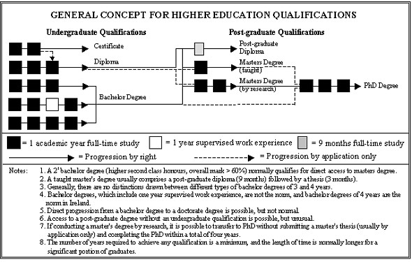
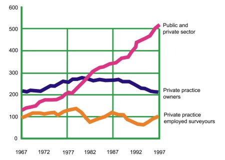
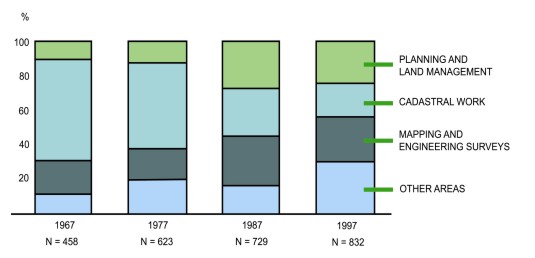
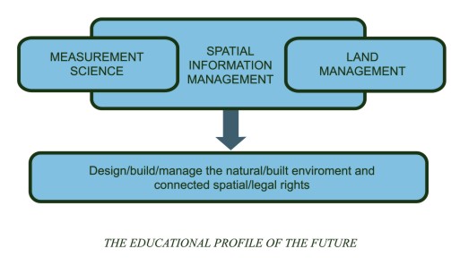
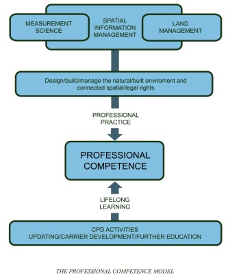
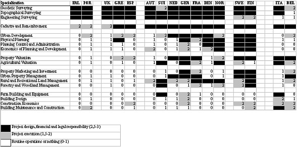

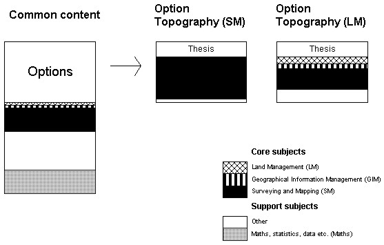
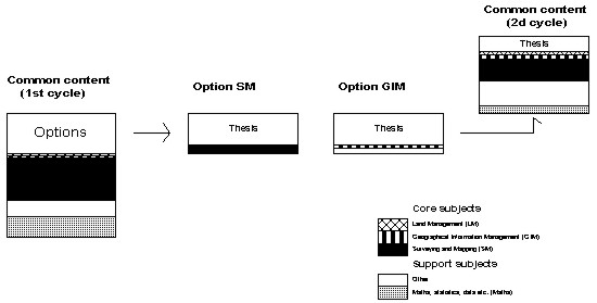
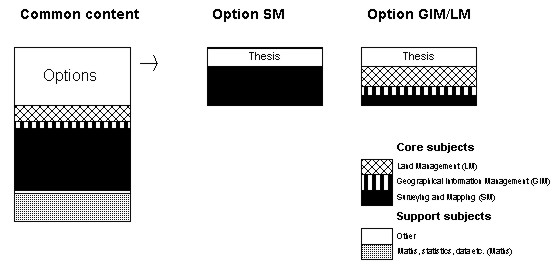
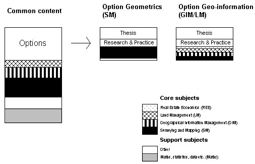
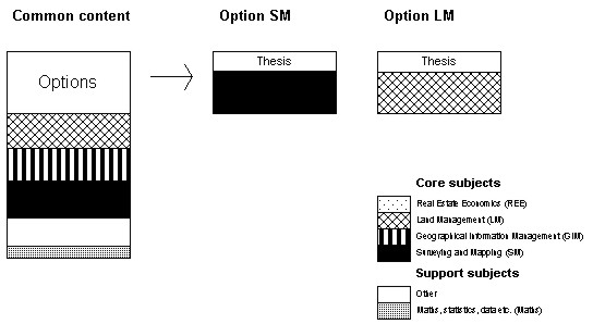
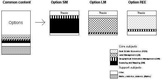
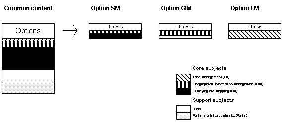
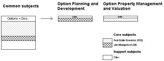
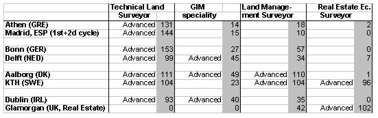
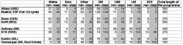

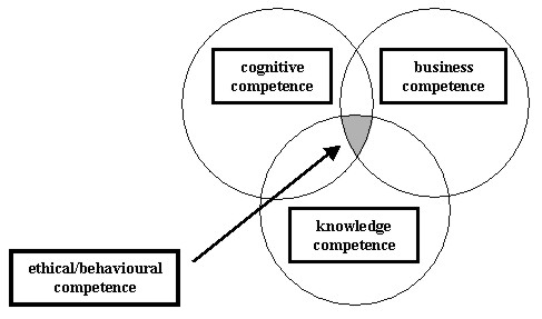
| Australia | Williamson, Ian | TU Delft / The University of Melbourne |
| Austria | Steinkellner, Gert | Österreichische Gesellschaft für Vermessung und Geoinformation - OVG |
| Belgium | Derwael, Jean-Jacques | Hogeschool Antwerp |
|
Czech Republic |
Zimová, Ružena | Czech Technical University in Prague |
| Denmark | Andersen, Jens Bruun | Den danske Landinspektørforening |
| Elmstrøm, Henning | Den danske Landinspektørforening | |
| Enemark, Stig | University of Aalborg | |
| Sørensen, Esben Munk | Danish Forest & Landscape Research Institute | |
Finland |
Rantanen, Matti | Espoo Vantaa Institute of Technology |
| Virrantaus, Kirsi | Helsinki University of Technology | |
| France | Bailly, André | Association Francaise de Topographie - AFT |
| Bour, Bernard | OGE, CEPLIS | |
| Kasser, Michel | ESGT - Le Mans | |
| Radier, André | Ordre des Géomètres-Experts - OGE | |
Germany |
Witte, Bertold | Geodätisches Institut der Universität Bonn |
| Schwenk, Walter | Bund der Offentlich bestellen Vermessungsingenieure | |
| Kohlstock, Peter | Bund der Offentlich bestellen Vermessungsingenieure | |
| Rürup, Klaus | Vice President, CLGE | |
| Greece | Billiris, Harilaos | National Technical University of Athens |
| Patias, Petros | Aristotle University of Thessaloniki | |
| Stavros, Christos | Technical Chamber of Greece | |
| Ireland | Murray, Helen | The Society of Chartered Surveyors |
| Prendergast, Paddy | President, CLGE | |
| Prendergast, Frank | Dublin Institute of Technology | |
| Norway | Leiknes, Arve | Høgskolen i Bergen |
| Revhaug, Inge | Agricultural University of Norway | |
| The Netherlands | Anneveld, Jos C | Nederlandse Vereiniging voor Geodesie - NVG |
| Bilagher, Moritz | Delft University of Technology | |
| Bogaerts, Theo | Delft University of Technology | |
| Fendel, Elfriede M | Delft University of Technology | |
| Kenselaar, Frank | Delft University of Technology | |
| Molen, Paul van der | NVG, ITC, FIG Commission 7 | |
| Molenaar, Martien | ITC | |
| Ormel, Jan W | Hogeschool van Utrecht | |
| Vosselman, George | Delft University of Technology | |
| Wijngaarde, Mark | Dutch Group in CLGE | |
| Klijn-Wuisman, Maria | Delft University of Technology | |
| Slovak Republic | Kopácic, Alojz | Slovak University of Technology Bratislava |
| Spain | Cavero, Pedro J | Universidad Politecnica de Madrid |
| Sweden | Mattsson, Hans | Royal Institute of Technology Stockholm |
| Switzerland | Sonney, René | Société suisse des mensurations et améliorations foncières - SSMAF |
| United Kingdom | Kavanagh, James | Royal Institute of Chartered Surveyors |
| Ledger, Rob | Royal Institute of Chartered Surveyors | |
| Plimmer, Frances | University of Glamorgan, Wales | |
| Rodgers, David | Institute of Civil Engineering Surveyors |
Appendix B
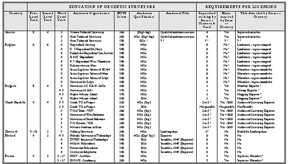
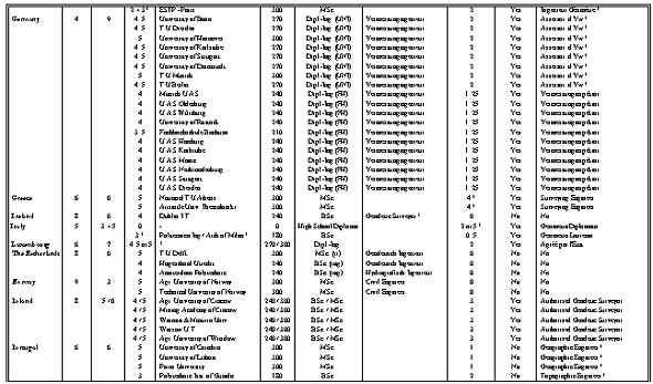
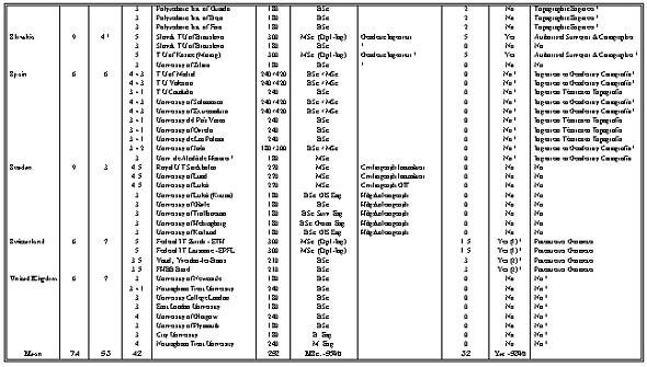
Appendix C
Educational Profiles at Universities Investigated
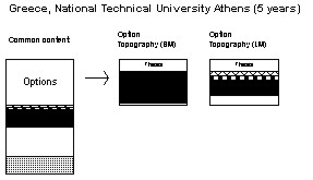
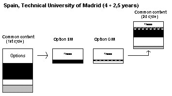
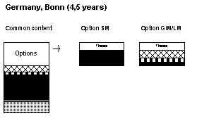
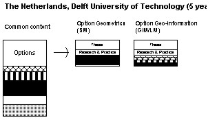
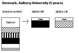
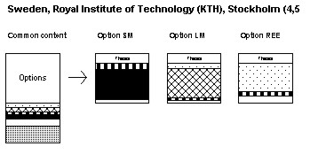

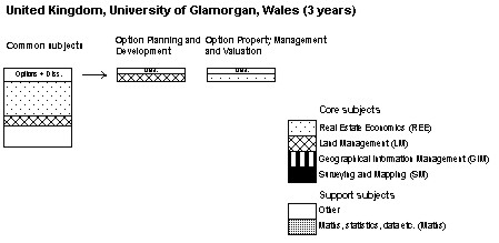
Appendix D
FIG Definition of "Surveyor"
At its General Assembly in Helsinki, Finland on 11 June 1990, FIG adopted the following definition of the surveyors' activities.
A surveyor is a professional person with the academic qualifications and technical expertise to practice the science of measurement; to assemble and assess land and geographic related information; to use that information for the purpose of planning and implementing the efficient administration of the land, the sea and structures thereon; and to instigate the advancement and development of such practices.
Practice of the surveyor's profession may involve one or more of the following activities which may occur either on, above or below the surface of the land or the sea and may be carried out in association with other professionals.
1. The determination of the size and shape of the earth and the measurement of all data needed to define the size position, shape and contour of any part of the earth's surface.
2. The positioning of objects in space and the positioning and monitoring of physical features, structures and engineering works on, above or below the surface of the earth.
3. The determination of the position of the boundaries of public or private land, including national and international boundaries, and the registration of those lands with the appropriate authorities.
4. The design, establishment and administration of land and geographic information systems and the collection, storage, analysis and management of data within those systems.
5. The study of the natural and social environment, the measurement of land and marine resources and the use of the data in the planning of development in urban, rural and regional areas.
6. The planning, development and redevelopment of property, whether urban or rural and whether land or buildings.
7. The assessment of value and the management of property, whether urban or rural and whether land or buildings.
8. The planning, measurement and management of construction works, including the estimation of costs.
9. The production of plans, maps, files, charts and reports.
In the application of the foregoing activities surveyors take into account the relevant legal, economic, environmental and social aspects affecting each project.
(FIG, 1991 p. 9)
Appendix E
Questionnaire
This research is commissioned and funded by the Comité de Liaison des Géomètres Européens (Council of European Geodetic Surveyors (CLGE)) and the Fédération International des Géomètres (International Federation of Geometers (FIG)). The objective of this Questionnaire is to seek information on which to develop threshold standards of professional competence for the different areas of surveying practised in Europe.
FIG has agreed the following definition of "surveyor". For one separate and recognised profession of "surveyor", please (a) give the title used by that kind of surveyor e.g. land surveyor and (b) tick the appropriate box(es) to indicate what surveying activities are included in each profession.
1. Country in which you practice . . . . . . . . . . . . . . . . . . . . . . . . . . . . . . . . . . . . . . . . . . . . . . .
2. Title used by the professional surveyor in this country: . . . . . . . . . . . . . . . . . . . . . . . . .
. . . . . . . . . . . . . . . . . . . . . . . . . . . . . . . . . . . . . . . . . . . . . . . . . . . . . . . . . . . . . . . . . . . . . . . . . . . .
3. Please tick appropriate box(es) to indicated what surveying activities are included in this profession.
A surveyor is a professional person with the academic qualifications and technical expertise to practice:
__ the science of measurement;
__ to assemble and assess land and geographic related information;
__ to use that information for the purpose of planning and implementing the efficient administration of the land, the sea and structures thereon; and
__ to instigate the advancement and development of such practices.
__ Practice of the surveyor's profession may involve one or more of the following activities which may occur either on, above or below the surface of the land or the sea and may be carried out in association with other professionals.
__ The determination of the size and shape of the earth and the measurement of all data needed to define the size position, shape and contour of any part of the earth's surface.
__ The positioning of objects in space and the positioning and monitoring of physical features, structures and engineering works on, above or below the surface of the earth.
__ The determination of the position of the boundaries of public or private land, including national and international boundaries, and the registration of those lands with the appropriate authorities.
__ The design, establishment and administration of land and geographic information systems and the collection, storage, analysis and management of data within those systems.
__ The study of the natural and social environment, the measurement of land and marine resources and the use of the data in the planning of development in urban, rural and regional areas.
__ The planning development and redevelopment of, whether urban or rural and whether land or buildings.
__ The assessment of value and the management of property, whether urban or rural and whether land or buildings.
__ The planning, measurement and management of construction works, including the estimation of costs.
__ The production of plans, maps, files, charts and reports.
In the application of the foregoing activities surveyors take into account the relevant legal, economic, environmental, and social aspects affecting each project.
__ Are any other activities involved? Please list them . . . . . . . . . . . . . . . . . . . . . . . . . . . . . .
. . . . . . . . . . . . . . . . . . . . . . . . . . . . . . . . . . . . . . . . . . . . . . . . . . . . . . . . . . . . . . . .
4. Please give the name(s) of the organisation(s) which regulate and/or licence the above surveying profession, if any.
Regulatory Organisation(s): . . . . . . . . . . . . . . . . . . . . . . . . . . . . . . . . . . . . . . . . . . . . . . . .
Regulatory Organisation(s): . . . . . . . . . . . . . . . . . . . . . . . . . . . . . . . . . . . . . . . . . . . . . . . .
Regulatory Organisation(s): . . . . . . . . . . . . . . . . . . . . . . . . . . . . . . . . . . . . . . . . . . . . . . . .
Licensing Organisation(s): . . . . . . . . . . . . . . . . . . . . . . . . . . . . . . . . . . . . . . . . . . . . . . . . .
Licensing Organisation(s): . . . . . . . . . . . . . . . . . . . . . . . . . . . . . . . . . . . . . . . . . . . . . . . . .
__ No regulatory or licensing organisations are involved
5. Please indicate the level of academic education required from University or other post-bac education prior to qualification in the profession.
__ baccalaureate plus 1 year;
__ baccalaureate plus 2 years;
__ baccalaureate plus 3 years (bachelors);
__ baccalaureate plus 4 years;
__ baccalaureate plus 5 years (masters);
__ baccalaureate plus more than 5 years.
6. Please give the title(s) of academic programmes which applicants to the profession would follow and the names of the Universities which offer such programmes.
. . . . . . . . . . . . . . . . . . . . . . . . . . . . . . . . . . . . . . . . . . . . . . . . . . . . . . . . . . . . . . . . . . . . . . . . . .
7. What additional requirements are imposed on an applicant with an appropriate diploma prior to the status of a surveying professional? (e.g. a period of supervised work experience; a practising certificate; award of a license; membership of a professional organisation)
. . . . . . . . . . . . . . . . . . . . . . . . . . . . . . . . . . . . . . . . . . . . . . . . . . . . . . . . . . . . . . . . . . . . . . . . . .
8. Are limitations imposed on the kind of work which an applicant with an appropriate diploma prior to the status of a surveying professional can undertake? Yes / No
If Yes, what are these limitations?
. . . . . . . . . . . . . . . . . . . . . . . . . . . . . . . . . . . . . . . . . . . . . . . . . . . . . . . . . . . . . . . . . . . . . . . . . .
9. Have threshold standards for entry into this profession been identified by any organisation(s) (e.g. the requirement to hold a licence, or demonstrate specified levels of skills)? Yes / No
If Yes, which organisation(s) has (have) identified threshold standards?
. . . . . . . . . . . . . . . . . . . . . . . . . . . . . . . . . . . . . . . . . . . . . . . . . . . . . . . . . . . . . . . . . . . . . . . . . .
10. If you are aware of the details, please list the threshold standards which are applied to applicants to this profession.
. . . . . . . . . . . . . . . . . . . . . . . . . . . . . . . . . . . . . . . . . . . . . . . . . . . . . . . . . . . . . . . . . . . . . . . . . .
If you are prepared to take part in a further in-depth interview, please staple your business card to this questionnaire.
Please return this questionnaire to:
Dr. Frances Plimmer, Reader in Applied Valuation, School of Technology, University of Glamorgan, Rhondda Cynon Taff, Wales, CF37 1DL, United Kingdom.
Thank you very much for completing and returning this questionnaire.
Appendix F
Joint CLGE /FIG Seminar at TU Delft, 3rd November 2000
"Enhancing Professional Competence of Geodetic Surveyors in
Europe"
Programme
Chaired by Prof. Kirsi Virrantaus, Chairperson FIG Commission 2 - Professional Education
| 09.30 | Registration & Coffee |
| 10.00 | Introduction - Prof. Stig Enemark, Aalborg University, Denmark & Mr Paddy Prendergast, Dublin Institute of Technology, Ireland |
| 10.30 | Methodology to Assess Professional Competence for the Different Areas of Surveying - Dr Frances Plimmer, University of Glamorgan, United Kingdom |
| 11.00 | Coffee |
| 11.30 | The idea of a Core Syllabus, input versus output approach? - Rob Ledger, Royal Institution of Chartered Surveyors, United Kingdom |
| 12.00 | Methodology to compare Curricula Content and Curricula Delivery - Prof. Hans Mattsson, Stockholm Technical University, Sweden |
| 12.30 | Lunch |
| 14.00 |
Two Breakout sessions Comparison of Curricula Content Models - Moderator Mr. Paddy Prendergast and Rapporteur Prof. Kirsi Virrantaus Assessment of Professional Competence - Moderator Prof. Stig Enemark and Rapporteur Prof. Frank Kenselaar |
| 15.30 | Plenary Session |
| 16.00 | End |
Enhancing Professional Competence of Surveyors in Europe
Stig Enemark and Paddy Prendergast (Ed.)
Printed in English
Copenhagen, Denmark
May 2001
ISBN 87-90907-11-6
Published by
The International Federation of Surveyors (FIG)
Lindevangs Allé 4
DK-2000 Frederiksberg
DENMARK
Tel. + 45 38 86 10 81
Fax + 45 38 86 02 52
Email: fig@fig.net
Web site: www.fig.net
and
The Council of European Geodetic Surveyors (CLGE)
BEV c/o VA Innsbruck
Bürgerstrasse 34
A-6010 Innsbruck
AUSTRIA
Tel. + 43 512 588 948 60
Fax + 43 512 588 411 61
Email: gerda.schennach@bev.gv.at
Web site: www.clge.org
![]()
This page is maintained by the
FIG Office. Last revised on 15-08-11.