ITEMS OF CADASTRAL COMPUTATIONS IN THE PBLIS OF KCSCProf. Byung-Guk KIM, Kwang-Seok KWON and Donghoon JEONG, KoreaKey words: LIS, Cadastral Computations, PBLIS, KCSC. AbstractThe surveying computations in the public land survey has been done in the manual manner and recorded in the given formats until now. PBLIS (Parcel Based Land Information Systems) is in the beginning stage of development as the progress of digitization of the cadastral records and the cadastral maps. Two modules are completed as parts of the PBLIS, the survey assistant module and the survey computation module. In this paper, the items of computations frequently used by the KCSC surveyors are selected, categorized, and listed according to the functional roles in the surveying computations. The system design, development and some main screens are shown and demonstrated. 1. INTRODUCTIONPublic land surveying (cadastral surveying) in Korea is performed exclusively by the KCSC(Korea Cadastral Survey Corporation). The KCSC deals with 31,331,000 parcels of land and 3,420,000 parcels of forest (or forestry land) as of the year of 2000. The total of 34,751,000 parcels are recorded and maintained in the forms of "cadastral records" and "cadastral maps", and also are registered in the local registry offices, which is under the local courts. (Cadastral records consist of 'land records', 'house records', and 'forest records'; Cadastral maps consist of 'land maps' and 'forest maps') And The KCSC is in charge of managing the records and the maps as well as surveying and updating the parcel maps. The records and maps have been written and drawn in the manual manner and stored in the paper forms, then photocopied for the public users until 1990. The land records and house records in text forms have been typed in from 1982 and completed in 1991 and began to be provided to the users through the nation-wide networks from 1991. The digitalization of the maps began in 1999 after a success of a pilot project of the 'digitalization of cadastral maps in Yusung-gu, Taejeon', conducted in 1997, of which the area were 176 km2 and 75,000 parcels. The total number of map sheets to be digitized is about 750,000, which hold about 34,700,000 parcels. About 182,000 map sheets have been digitized as of the end of year 2000, and the rest are scheduled to be complete through 2003. The KCSC is encouraged to develop a Parcel Based Land Information Systems (PBLIS) using the digitized records and the digitized maps. The project began in 1997 and parts of the system (the land surveying session assistant module and the land surveying computation module) came into being existence, and the test version of the system is out to the users for debugging purpose. (Figure 2) In this paper, the items necessary for land surveying measurements and computations are collected and implemented for the perspective PBLIS. The screens for the data input, computations, and display are also developed.
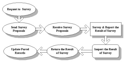
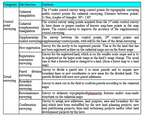
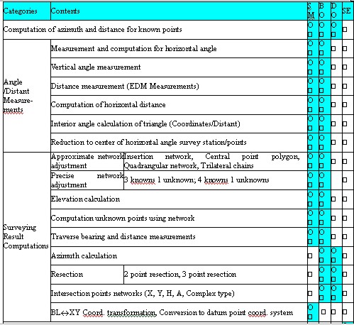
Figure 1. The Process of Cadastral Survey 2. ITEM DEVELOPMENTSComputation items were developed after interviewing the surveyors in the KCSC. Almost all the computation items they use in preparation, in field work, in office work, and in recording and map making are believed to be identified including the frequently used items, time consuming ones and complex ones. The job procedure for the surveyors is shown in Figure 1. In the job procedure, "field surveying and recording" is the one this paper is focused on. The field surveying can be classified in two categories, control point surveying and detail surveying, and each of which has 3 and 6 sub-categories respectively, as in Table 1. For the surveys listed in the Table 1, the computational functions selected to accomplish the purpose of the surveys are shown in Table 2. A computation function can be used in SM(Cadastral Triangulation), BO(Cadastral Complementary Triangulation), DO(Supplementary Control Surveying), and/or SE(Detail Surveying). In the case of complementary triangulation, it uses most of functions for the triangulation and the supplementary control surveying, but the computational accuracy differs a little. Table 1. Surveying categories and the contents
Table 2. Computational functions
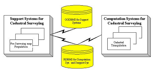
3. SYSTEM DESIGNBased upon the requirements of the field surveyors, the system has been designed as in the Figure 2. The computational module is combined with the surveying assistant module, and the two modules use the same database. While the survey assistant module and the graphical part of the computational module adopted a tool named 'Gothic' by Laser Co, Inc., which is an Object Oriented DBMS and will be the engine of the final PBLIS, the attribute part of the survey computation module used the 'Oracle' relational DBMS. All the queries can be placed in the standard SQL.
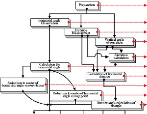
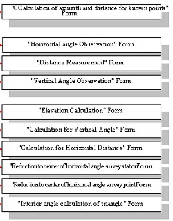
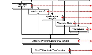
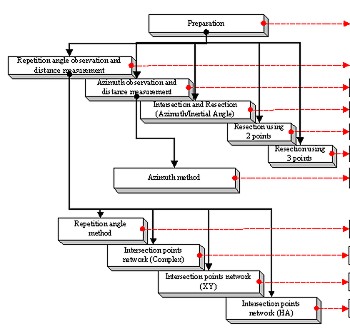
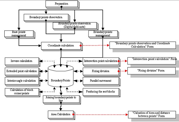
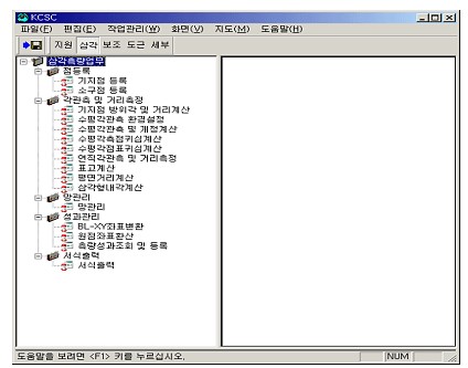
Figure 2. System Configuration The survey computation module consists of 4 sub-modules: Triangulation Module, complementary control point surveying module, supplementary control point surveying module, and detail surveying module. Each module has routines to print out the computation results in the forms designated by the KCSC. In Figures 3, 4, and 5, the flow of computational menus implemented in the system can be seen, and also the name of output formats for every calculation. The lines in the figure imply the flow of the data, that is, the previous steps have to be completed and the resulting data are necessary to perform the job in the current step. The final products (output formats) are shown in the right most boxes.
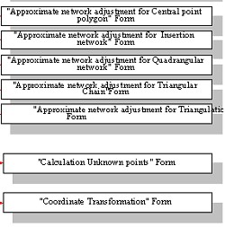
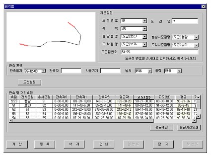
Figure 3. Triagulation Module
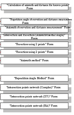
Figure 4. Supplementary Control Point Surveying Module
Figure 5. Detail Surveying Module 4. SYSTEM DEVELOPMENTThe survey computation program has to be operated with the main execution file, output format file, and reference drawing control file. The execution file works with the Win32S environment, and output format file uses the 'Enhanced Metafile' format. The reference drawing control file is produced in 'ActiveX Control' and uses the OpenGL library provided with the operating systems. The requirements for the operation of the system are as follows;
Data can be handled in both the project files and the DB. That is, the system can be operated in stand-alone mode (without DBMS) because the data are collected in field condition and some computations have to be done in field to check the data.
5. PROGRAM DESCRIPTIONSSome screens are shown here. In the 2nd tool bar in Figure 6, there are 5 buttons, saying, assistant, triangulation, complementary, supplementary and the detail. By pressing a button, for example, 'triangulation' button in the figure, the screen shows the sub-routines for any computations as a menu tree.
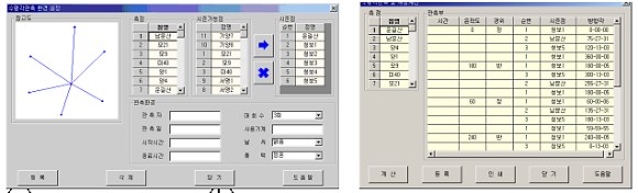
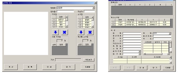
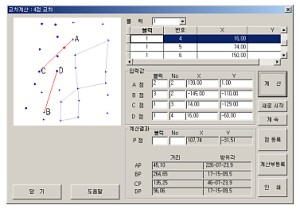
Figure 6. Main View Some sub-menu screens under the 'triangulation' button are shown in Figure 7. (a) shows the selection of known points from the DB and inputting windows for unknown points. (b) shows some data collected by the horizontal angle measurements. (c) shows the network adjustment setting, and (d) shows the results of the adjustment.
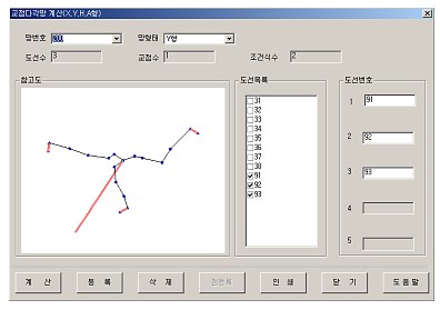
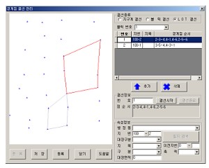
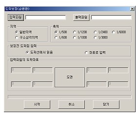
Figure 7. Dialog boxes for Triangulations Figure 8 is the screens of sub-modules under the 'supplementary' button
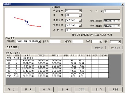
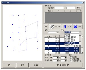
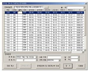
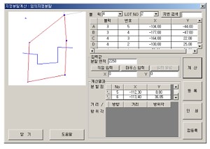
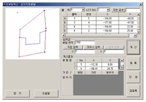
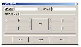
Figure 8. Dialog boxes for Supplementary Control Point Surveying 'Detail' button has screens as in Figure 9.
Figure 9. Dialog boxes for Detail Surveying 6. CONCLUSIONSItems of cadastral survey computations, as parts of the PBLIS, are developed and modules are implemented for inputting data, computation and adjustment, and outputting in certain formats. The process adopted in the development is resembling the process currently being used by the KCSC surveyors in the manual manner. It is found to be necessary to revise the way of data collection, input and output formats (by revising the provisions of laws) because there are many cases that the old method are no longer valid in the new era of computers and DB environment. The cases are: logarithm calculations for the trigonometric al functions, repeated steps and writings of the calculations, rounding offs after every calculations and significant figures problem, and the provisions of sketch maps. Also, GPS data collection and process must be considered and included in the modules. 7. REFERENCESPaul R. Wolf, Charles D. Ghilani, 1997, ADJUSTMENT COMPUTATIONS : Statistics and Least squares in Surveying and GIS, New York : John wiley & Sons, Inc. Richard L. Burden, J. Douglas Faires, Numerical Analysis, 1997, Pacific Grove : Brooks/Cole Publishing Company. Stephen C. Guptill And Joel L. Morrison, 1995, Elements of Spatial Data Quality, Oxford : Pergamon. National Computerization Agency, 1993, A Building Plan of Korea Comprehensive Land Information Systems, Seoul. National Computerization Agency, 1994, A Building Work of Korea Comprehensive Land Information Systems, Seoul. BIOGRAPICAL NOTEAssociate Professor Byung-Guk Kim works at the Department of Geoinformatic Engineering at the University of Inha. His positions held include:
His academic Awards and distinctions are:
He is a member of the following associations: Korean Society of Civil Engineers, Regular Member (1990-), Geographic Information System Association of Korea, Regular Member (1993-), Korean Society of Geodesy, Photogrammetry and Cartography, Regular Member (1990-), Korea Open Geographic Information Systems Research Society, Regular Member (1998-), Korean Society of Remote Sensing, Regular Member (1998-), Korean Association of Surveying & Mapping, Member (1998-), Korean Society of Transportation, Regular Member (1994-), ASPRS (American Society for Photogrammetry and Remote Sensing), active member(1984-). CONTACTAssoc. Prof. Byungguk Kim, Ph.D. PE Kwang-Seok Kwon Donghoon Jeong 11 April 2001 This page is maintained by the FIG Office. Last revised on 15-03-16. |
||||||||||||||||||||||||||||||||||||||