STUDY ON URGENT ESTABLISHMENT OF TOPOGRAPHIC
MAPPING IN EAST TIMOR - CREATION OF TOPOGRAPHIC INFORMATION FOR
ESTABLISHMENT OF CADASTRE IN EAST TIMOR
Toru WATANABE, Japan
Key words:
- The first digital topographic mapping in East Timor after the
violence following the independence vote in September 1999.
- Cadastral and other necessary data for mapping were lost
during the violence.
- Many houses and buildings were destroyed or burned out.
- Complications in land ownership and use of public facilities
and buildings.
- Public facilities data using GIS.
1. BACKGROUND OF THE PROJECT
In response to a request from the United Nations Transitional
Administration in East Timor (UNTAET), the Government of Japan decided
to conduct a "Study on the Urgent Establishment of Topographic
Mapping in East Timor" ("the Study").
This Study was carried out by the Japan International Cooperation
Agency, the official agency responsible for the implementation of the
technical cooperation programs of the Government of Japan. Asia Air
Survey Co., Ltd. sent a Study Team to East Timor under contract with
JICA and carried out field work in East Timor and office work in
Japan.
The Study area covers Dili City and its surrounding area in East
Timor. The total study area is 107 square km for 1:2,000 scale digital
topographic mapping and digital GIS data preparation. The Study was
started in February 2000 and ended September 2000, and was the first
digital topographic mapping carried out in East Timor after the
violence following the independence vote in September 1999.
Location Map of East Timor
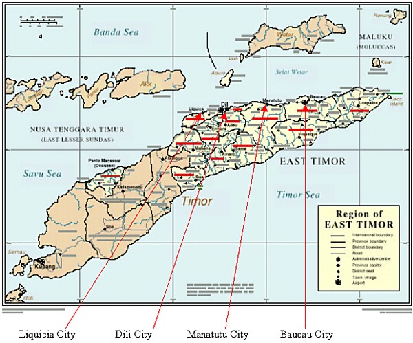
The Study Area
1. Aerial photography area |
1) Dili City
2) Manatutu City
3) Baucau City
4) Liquicia City |
107 square km
50 square km
72 square km
28 square km |
| 2. Digital topographic mapping and
GIS data preparation area |
| 1) Dili City |
107 square km (83 sheets) |
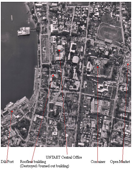
Aerial Photo of the Center of Dili City
Field Photo
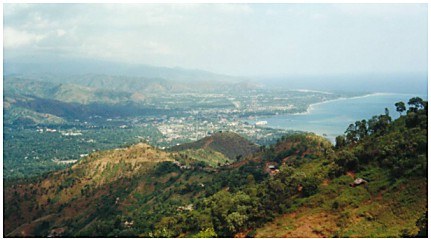
Panoramic view of Dili City
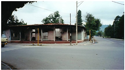
Houses destroyed / burnt in September 1999 in Dili
City
2. PROBLEMS IN EAST TIMOR
East Timor and Dili City have the following serious problems
related to topographic maps at present.
- The only available topographic maps of East Timor were basically
the 1:25,000 scale topographic maps put together by BAKOSURTANAL
(Indonesian Survey and Mapping Authority) of the Republic of
Indonesia in the 1990's (aerial photos taken in the 1980's and
1990's were used for 1:25,000 scale topographic mapping). In
addition, other partial topographic maps of larger scale were also
available, but those maps had been expanded and compiled from the
1:25,000 scale topographic maps.
- The leveling network and GPS points network had been established
by BAKOSURTANAL during the Indonesian period. The concrete
monuments of benchmarks and GPS points still exist in East Timor.
However, documentary descriptions of benchmarks and GPS points,
coordinates lists etc., were lost during the violence following
the independence vote in September 1999.
- The Indonesian Government's documents (statistic data, land
registration data, resident registration data etc.,) were also
lost during the violence following the independence vote in
September 1999.
- Since land use data were destroyed during the violence after
September 1999, many disputes have arisen in connection with land
ownership within Dili City. In order to settle these disputes,
there is an urgent need to develop large scale topographic maps,
to conduct a land-use survey and to build a database system
ensuring that the results of the land use survey are properly
arranged on the newly developed large scale topographic maps.
- The facilities and buildings owned by the former Indonesian
Government will belong to East Timor after its independence, but
what facilities and buildings exist in which areas is not
accurately known, because of the loss of the Indonesian Government
data. Therefore, it is necessary for these facilities and
buildings to be clearly defined as the national property of East
Timor, before UNTAET turns over the reins to the future Government
of East Timor.
- A number of public facilities, buildings and houses within Dili
City were damaged / burned out during the violence after September
1999. Therefore, it is necessary for a survey to be carried out to
determine what level of damage buildings and houses in each area
were subjected to, and to prepare a survey report so that planning
for the reconstruction of Dili City can begin promptly.
3. USE OF PUBLIC FACILITIES AND BUILDINGS
Many houses and buildings in Dili City were destroyed / burned out
during the violence following the independence vote in 1999, and most
of them remained damaged at the time of map creation.
There were over 450 public facilities and buildings and
approximately 50 schools in the mapping area. Most of the facilities
and buildings were owned by the Indonesian Administration. Some of
them were burnt / destroyed and closed down, while others were not
burnt but simply closed down, or used for other purposes.
The ownership and use of public facilities and buildings is a
complicated matter compared with other areas. The use of public
facilities and buildings is classified into three types, as follows:
- Public facilities and buildings from the Indonesian period that
remain damaged and unused after being damaged during the violence
following the independence vote of September 1999.
Example:
Indonesian Period: Office of Ministry of Public Works of Indonesia
Present time: Remains damaged and abandoned
- Public facilities and buildings from the Indonesian period that
were damaged or undamaged, but that have been restored by a UN
organization and are now in use.
Example:
Indonesian Period: Indonesian Provincial Government Office
Present time: Central Office of UNTAET
- Public facilities and buildings from the Indonesian period that
were damaged or undamaged, but are now used for the same purposes
as during the Indonesian period.
Example:
Indonesian Period: Elementary school
Present time: Still used as an elementary school.
4. CHARACTARISTICS OF DIGITAL TOPOGRAPHIC MAPS
In view of the background described above, the Study Team
determined that the 1:2,000 scale digital topographic maps to be
created under this Study should be different from the general
topographic maps for other areas, and decided to create these maps by
the following method:
- Method used for creation of 1:2,000 scale digital topographic
maps
- Damaged and undamaged buildings and houses
It is necessary to classify the damaged and undamaged
buildings and houses on the 1:2,000 scale digital topographic maps
to be created. For this purpose, the following methods were
applied
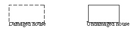
a) Ordinary houses
Ordinary houses are classified by photo interpretation in
plotting, based on whether the house has a roof or not, as follows:
Example:
Ordinary house with roof:
Undamaged house - drawn in unbroken lines
Ordinary house without roof: Damaged house -
drawn in broken lines
b) Public facilities and buildings
Damaged or undamaged public facilities and buildings are
determined basically in the same way as ordinary houses, using photo
interpretation in plotting. However, many of those public facilities
and buildings have been restored and are now being used by UNTAET or
PKF.
Therefore, in addition to the ordinary field identification,
further detailed data and information were required for 1:2,000
scale digital topographic maps. Inventory study data sheets were
prepared to verify each of the public facilities and buildings on
the spot and check whether it has a roof or not, whether it is burnt
or not, its restored status and whether it is in use or unused.
These inventory data sheets were attached to each public facility
and building as attribute data on the 1:2,000 scale digital
topographic maps, using GIS.
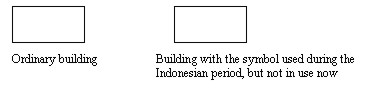
- Representation of symbols for public facilities and buildings
As mentioned previously, ownership and use of public
facilities and buildings takes three forms. Therefore, it is
necessary for the form of ownership / use of the facility or
building to be represented on the map. In the 1:2,000 digital
topographic maps, the following symbols were adopted in
representing public facilities and buildings.
a) If the current ownership and use of a public facility or
building is the same as during the Indonesian period, the symbol for
the current use is adopted.
Example:
Indonesian Period: Elementary school
Present time: Elementary school - Use the symbol for elementary
school
b) If the current ownership and use of a public facility or
building is different from what it was during the Indonesian period,
the symbol for the currently use of the public facility or building
is adopted.
Example:
Indonesian Period: Indonesian Government Office
Present time: UNTAET - Use the symbol for UNTAET
c) If a public facility or building from the Indonesian period
remains damaged and unused, the symbol for the public facility or
building during the Indonesian period is used. However, bold lines
are used to represent the building, to indicate that it is not
classified according to its present ownership and use.
Example:
Indonesian Period: Office of the Ministry of Public Works of
Indonesia - Use the symbol for Government office.
Present time: Unused and abandoned
d) For buildings and facilities owned by or connected with the
Indonesian military, symbols for Indonesian military facilities were
created.
5. CONCLUSION
One of the important objectives in the creation of 1:2,000 scale
topographic maps in this Study was that the maps should be prepared as
soon as possible so that they may be used in preparation for the
soon-to-be-commenced reconstruction of urban facilities in Dili City
and in tackling the problems (especially land ownership disputes)
faced by Dili City, the largest city in East Timor.
However, most of the materials necessary for the creation of
digital topographic maps were lost during the violence after September
1999. Thus, the Study Team had to collect through field identification
the various types of information necessary for the creation of digital
topographic maps.
In addition, many of the urban facilities, buildings and ordinary
houses had been damaged during the violence after September 1999 in
the areas to be covered in the digital topographic maps created in
this Study. Some of the governmental facilities and buildings used in
the Indonesian period are now used by UNTAET and PKF, but others have
been abandoned.
Therefore, the specific circumstances in which Dili City is
currently placed, and many other conditions, had to be considered with
regard to the application of the topographic maps to be created. The
Study also involved much trial and error in determining how the
information regarding these new conditions should be represented on
the digital topographic maps.
As described above, in comparison with work for other areas the
Study faced many difficulties in the creation of digital topographic
maps, in terms of the time required and the content of the work. It is
also anticipated that the topographic maps will be subject to on-going
changes as progress is made in the reconstruction of Dili City.
Dili City is undergoing rapid restoration after the troubles of
September 1999, thanks to assistance from many countries and
investment by the private sector. However, the 1:2,000 digital
topographic maps created in the Study are based on information from
aerial photos taken over a short period of time, from the beginning to
the end of April 2000 and the results of the field survey carried out
over a period lasting from the middle of April to the end of May 2000.
The restoration of Dili City is now proceeding at a faster pace
than it was at the time the Study Team started the Study in East
Timor. Therefore, the digital topographic maps will soon contain many
discrepancies from actual conditions unless they are modified
continuously.
In particular, the following data should be modified continuously:
1) Symbols for public facilities, etc.
The buildings and facilities marked with symbols indicating that they
are the facilities of UN organizations such as UNTAET and PKT will
have to be modified when use of UNTAET or PKF, etc. terminates.
2) Symbols for damaged buildings and houses
As the damaged buildings and houses are represented by broken lines,
the representations of these buildings and houses should be changed
into the symbol (unbroken lines) for undamaged buildings and houses
when they are repaired or rebuilt.
3) Symbols for facilities and buildings of the Indonesian
military
Facilities and buildings of the Indonesian military are marked with
the symbol (?) on the topographic maps. The basic principle of
topographic maps is that the current purpose or status of use of the
facilities and buildings should be represented on the maps.
On the topographic maps created in the Study, facilities and buildings
used by the Indonesian military are marked with the symbol (?).
However, these facilities and buildings will be used for other
purposes in future, and the symbol for those facilities will have to
be changed accordingly.
4) Representation and symbols for governmental facilities and
buildings from the Indonesian period that are not currently used
Governmental facilities and buildings from the Indonesian period that
are not currently in use are represented with bold lines and marked
with symbols indicating their use during the Indonesian period. The
representations and symbols for these facilities and buildings will
also have to be changed if they come to be used for other purposes.
REFERENCES
WATANABE Toru, August 2000, Final Report for the Study on Urgent
Establishment of Topographic Mapping in East Timor, Tokyo, Japan
International Cooperation Agency
WATANABE Toru, August 2000, Summary of Final Report for the Study
on Urgent Establishment of Topographic Mapping in East Timor, Tokyo,
Japan International Cooperation Agency
BIOGRAPHICAL NOTE
Toru Watanabe (born 1951)
Position and employer
Manager, Survey and Mapping Expert
Overseas Operation Division, Asia Air Survey Co., Ltd.
Projects undertaken recently
1. Study of National Topographic Mapping of the Kita Area in the
Republic of Mali (December 2000 - March 2001)
2. Way Sekampong Irrigation Project in the Republic of Indonesia (July
2000)
3. Study on Urgent Establishment of Topographic Mapping in East Timor
(February 2000 - September 2000)
4. Detailed Design of the Gilirang Irrigation Project in the Republic
of Indonesia (May 1999 - January 2000)
5. Yangze River Civilization Project in China (October 1998 - November
1998)
6. Development Study on the Nationwide Ferry Service Routes in the
Republic of Indonesia Phase II (April 1997 - March 1998)
7. Contact Mission for National GIS Project in Angora (December 1996)
8. Scope of Work Mission for Topographic Mapping, Angkor
Archaeological Area in the Siem Reap Region in Cambodia (September
1996 - October 2000)
9. Project Formation Mission in the Kingdom of Cambodia (February 1996
- March 1996)
10. Detailed Design on the Batang Hari Irrigation Project in the
Republic of Indonesia (January 1995 - May 1995)
CONTACT
Toru Watanabe
Overseas Operation Division
Asia Air Survey Co., Ltd.
Shinjuku-Kofu Bldg. 2-18
Shinjuku-4
Shinjuku-ku
Tokyo 160-0022
JAPAN
Tel. + 81 3 5379 2891
Fax + 81 3 5379 2890
E-mail: Aaswatanabe@aol.com
30 April 2001
This page is maintained by the
FIG Office. Last revised on 15-03-16.
|