TWO STANDARDS ON DIGITAL MAPS AS PART OF THE HUNGARIAN NSDIDr. Szabolcs MIHÁLY, HungaryKey words: digital map, map standards, cadastral map, topographic map, base map, structural standard, content standard, instruction, DAT, DITAB. 1. INTRODUCTIONBased on the standardisation of geoinformation in frame of CEN TC 287 and partly ISO TC 221 and taking into account the Hungarian conventions as well as the Hungarian Law on Surveying and Mapping (1996) two standards on digital maps has been issued in Hungary last 4 years. The first standard is the conceptual model on digital basic map (on multicadaster map) issued by the Hungarian Board of Standards nomenclatured as MSZ 7772-1:1997. The standard has been realised in life using also the digital base map instructions. The MSZ 7772-1:1997 standard and its instructions has been applied and proved fully appropriate for the practice during 3 years of surveying practise in the frame of the National Cadastre Program. The second standard is the conceptual model of Digital Topographic Data Base. The Hungarian Board of Standards issue number is MSZ 7772-2:2000. Recently the connected digital topographic data base instructions are elaborated in draft. Next year digital cartographic database conceptual model is expected to be issued. 2. ANTICEDENTS TO HUNGARIAN MAP STANDARDSIn Hungary the cadastral maps have been functioning from the middle of 19th century. Beginning with 1950s the, so called, multicadastral maps become practical with both legal and technical features on it, called surveying maps. In 1970-s the cadastral maps have been integrated with the land registry data as well as a unique projection system EOV (Egységes Országos Vetület, Unique Hungarian Projection) introduced with scales 1:1000 and 1:2000 for built-in areas and 1:4000 for rural ones. Till now the country is covered with these surveying base maps, sometimes mixed with the earlier 1:1440 and 1:2880 scale cadastral ones. They are continuously maintained by the civilian Mapping Agency as the land registry data are changing. Another type of the maps - the topographic ones with large, medium and small scales have been covering all the country from a long time ago. Till the middle of 20th century these topographic maps have been maintained by the Hungarian Defence and then divided also for the civilian Mapping Agency. Naturally, for both the large scale surveying base maps and the topographic maps of different scales well functioning instructions were elaborated and used. They reflected the wishes and purposes of the data owner/provider and the technical possibilities and means of the age by data capture organisations. They have been agreed with the ministries of interest (as summit or centralised, rather than user-oriented) but these instructions did not get a national-wide effective standard level, as well as no law but ministry order level on surveying and mapping was in effect which would provide right accommodation of the instructions in the economic life of the country. First time in surveying history of Hungary in 1996 the Law on Surveying and Mapping (LSM) has been legislated. This LSM prescribes to use the state base map for any GI database in Hungary as mandatory. The LSM divides the state obligation task of the geodetic control networks, of the state surveying base maps and the state topographic maps of 1:10 000 scale to the civilian Mapping Agency, and the state topographic maps of the scales smaller than 1:10 000 to the Hungarian Defence Forces. Meanwhile, end of 1980s the era of computers and information society started. Digital base map became necessary for geographic information. The same time a world-wide GI standardisation has been began mainly from a structural point of view of the GI data bases, first in dominant mapping agencies of the world, second in the frame of international standard organisations (CEN, ISO, OGC). It becomes necessary to convert the analogue maps into digital ones. After some years of trying to do that in sporadic ways with different methods, commercial software and approaches the surveyors and GI professionals established in frame of Hungarian Board of Standards the Technical Committee 818 on GI-standardisation. A series of digital map standards have been started to develop. The first in the series was the digital base map (likely a digital version of the state surveying base map), and the second was the digital topographic map standard. 3. REQUIREMENTS TO MAP DATABASE STANDARDISATIONRequirements for these (and further) map standards have been formulated as
The international GI structural standard used too derive the Hungarian map data base content standards were those of CEN and ISO which got readiness to be used and which have been coincidancing to each other, namely: prestandards on spatial schema, quality, metadata and position. 4. TWO HUNGARIAN STANDARDS ON MAP DATA BASESBased on selected international structural GI prestandards two Hungarian content standards on map databases have been defined as it follows in chapters 4.1.and 4.2. 4.1. Standard on Digital Base MapIn process of standardization from 1995-96 the Institute of Geodesy, Cartography and Remote Sensing (FÖMI) developed the standard on digital base map. By its content it is built such that providing a well-harmonized continuity with respect to the earlier large scale map prescription. During development of the DAT-standard all the user-types, data capture organizations and the institutions of data owner Land and Mapping Agency organization network represented themselves in 10 nation-wide meetings, altogether 450 persons. These meetings have been managed by FÖMI with help of the National Commitee on Technological Developments (OMFB) and the GI-standardization committee TC-818 of the Hungarian Body of Standards (MSzT) as well as supported by Lands and Mapping Department (LMD) of the Ministry of Agriculture (MoA). The MoA/LMD (as national mapping agency headquarters for Hungarian Lands and Mapping activity) accepted the standard preparation results and the MSzT issued the first volume of map data base standard series at the beginning of 1997: MSZ 7772-1:1997 Digital Maps: Part one: Digital Base Map Conceptual Model This standard is referred to in Hungarian as "DAT-Standard" by its Nick-name. The DAT-Standard gives prescription of the following main groups of information:
Prescriptions are formulated as adequate to resolution available in scale band 1:1000-1:4000. The data handling unit is the settlement. 4.2. Standard on digital topographic data baseLater, in 1999-70 the FÖMI and Topographic Office of the Hungarian Defence Forces (MH TÉHI) prepared the standard on digital topographic data base fulfilling the requirements as given in chapter 3. During development all the data owners represented themselves in 3 nation-wide panel discussions, altogether 180 persons. As a result the second volume of map data base standard has been elaborated, discussed, accepted and issued by the GI-standardisation committee TC-818 of the Hungarian Body of Standards: MSZ 7772-2:2000 Digital Maps: Part two: Definition of Digital Topographic Data Base. This standard is referred to in Hungarian as "DITAB-Standard" by its Nick-name. The DITAB Standard gives prescription of the 1:10 000 scale/resolution classical topographic, providing data base for later cartographic portrayal (the cartographic portrayal will be later standardised as "Digital Cartographic Data Base", DIKAB for different smaller scales). The data handling unit is the 1:10 000 scale map sheet. 4.3. Description of the conceptual model of the standardsThe following chapters of DAT- and DITAB-Standards are describing conceptual model:
In case of DAT-Standard the following annexes are given:
In case of DITAB-Standard the following annexes are given:
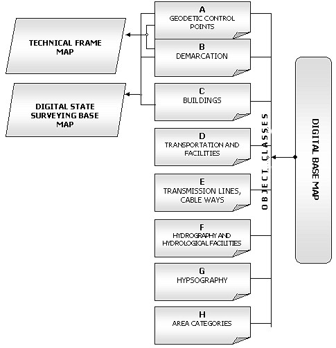
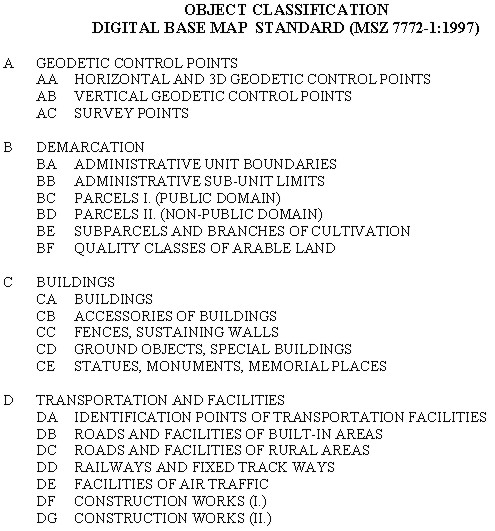
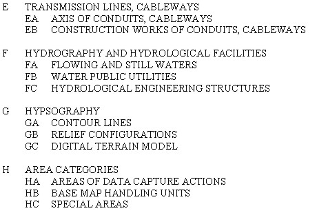
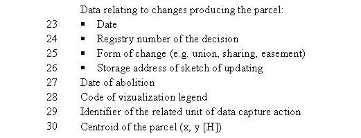
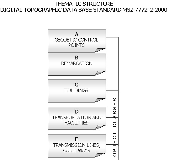
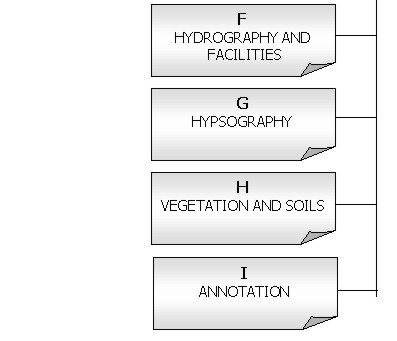
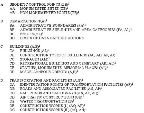
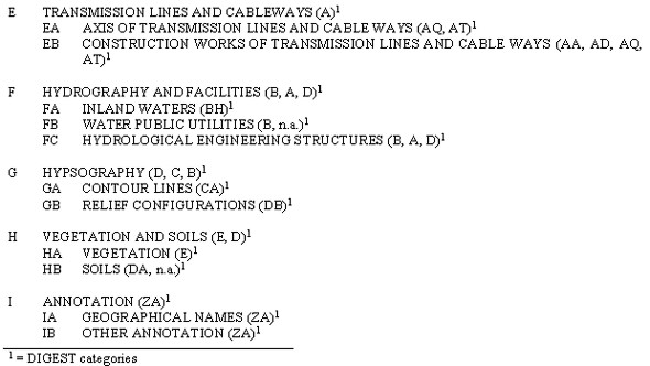
4.4. Structure and Object Classification of Map Database StandardsThe digital maps are represented in object-oriented relational database. The specific objects are described by their attributes, relations and data quality parameters. At conceptual model level the specific objects are represented by their generic objects. Those objects for which the attributes are common are grouped into one object group. The object groups having common attributes at higher level are grouped into one object classes. Three object types are distinguished by its geometry: point, line, surface objects. The objects are managed by full-topology requirement. The topology elements distinguished are: node, edge and face. The nodes are divided into more specific types. By geometry, the digital base map databases are 2-dimensional with planimetric coordinates. The hights are or can be given as attributes. The attributes, relations and quality parameters are defined in the standard as generic. Their values are given in supplementary instructions. The "Thematic Structure", the "Object Classification" and the "Example Attribute Table" are annexed, for the DAT-Standard and for the DITAB-Standard. In the DITAB-Standard the objects and attributes are harmonised with the DAT-Standard as well as with the DIGEST standard for NATO-compatible actions of the Hungarian Defence Forces. 4.5. Physical Model to the Standards4.5.1. Physical model of the digital base map Based on the DAT-Standard a series of instructions has been elaborated for physical model of Digital Base Map which are detailed prescriptions of how to develop the map itself. During the elaboration by FÖMI, the instructions have been critically discussed by representatives of land offices, MoA/LMD and data capture organizations. Finally, end of 1996 the following DAT-Instructions have been issued by MoA/LMD: DAT1. Instruction on "Planning, producing, renewing, documenting, checking, quality-checking, certifying and state acceptance of Digital Base Maps". Budapest, 1996. DAT1-M2. Supplement Instruction on "Structure, data tables, exchange format and handling rules of Digital Base Maps". Budapest, 1996. DAT1-M2. Supplement Instruction on "Legends for printing the Digital Base Maps". DAT1-M3. Supplement Instruction on "Checking and certifying the inner consistency of data of Digital Base Maps". Budapest, 1996. DAT2. Instruction on "Digitizing the multipurpose analog cadastral maps and its quality checking." Budapest, 1996. DAT2-M1. Supplement Instruction on "Transformation between different projection systems used in Hungary, with special emphasis on transformation to the regular projection system EOV." Budapest, 1996. 4.5.2. Physical model of the digital topographic data base Based on the DITAB-Standard a series of draft instructions has been elaborated for physical model of Digital Topographic Data Base which are detailed descriptions of how to develop the data base itself. The instructions have been elaborated by the civilian FÖMI and the MH TÉHI of the Defence Forces. The instructions are:
5. EXPERIENCES5.1. Experiences of Using the DAT-Standard and -InstructionsDuring 1997-2000 the DAT-Standard and -instructions have been experienced in the National Cadastre Program of Hungary.
5.2. Experiences of Using the DITAB-Standard and -InstructionsThe DITAB-Standard has been issued just at the end of 2000 as well as the DITAB-Instructions have only been prepared in draft version. Finalisation and issue of DITAB-Instructions are expected in 2001 by the Ministries concerned. As a consequence, no experiences have been obtained with the DITAB. This year a pilot is planned to be surveyed and handled in the digital topographic data base.
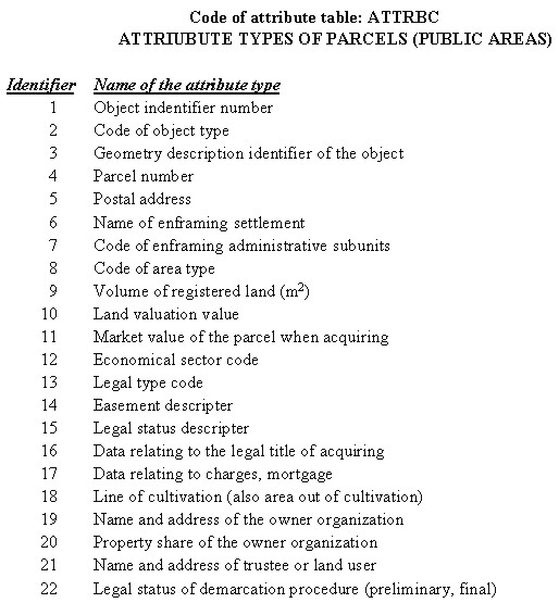
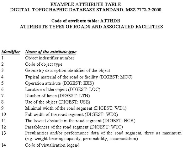
EXAMPLE ATTRIBUTE TABLE
|
 |
 |
 |
 |
|
|
 |
 |

BIOGRAPHICAL NOTE
Szabolcs Mihály
Academic experience: Dipl. Photogrammeter-Surveyor (Institute of
Geodesy, Ariel Survey and Cartography, Moscow, 1967), Doctor Tech.
(Budapest Technical University, 1982), Ph.D. degree (Hungarian Academy
of Sciences, 1981)
Practical experience: Satellite geodetic techniques and GPS,
elaboration of satellite geodetic adjustment software systems,
elaboration and nationwide harmonisation of the Hungarian
"Digital base map" standard and "Digital topographic
map database" standard, coordination and successful realization
of numerous national and international R+D project, database modelling,
National Spatial Data Infrastructure, coordinate system
transformation.
Publications: lecture notes, monographs, more than 90 papers published
in proceedings and registered journals, similar amount of internal
reports, a big part of it on GIS and digital cadastre.
Recent membership: Geodetic Scientific Committee of HAS (subcommission
chairman), Chairman of GI Standard's WG of Hungarian Office of
Standars, Representative to Eurogeographics, Hungarian representative
to FIG Commission 3.
Recent position: Director, Institute of Geodesy Cartography and Remote
Sensing, Hungary.
CONTACT
Dr. Szabolcs Mihály
Institute of Geodesy, Cartography and Remote Sensing, Hungary
Bosnyák tér 5
H-1149 Budapest
HUNGARY
Tel. + 36 1 222 5111
Fax + 36 1 222 5112
Email: szabo@fomigate.fomi.hu
21 April 2001
This page is maintained by the FIG Office. Last revised on 15-03-16.