|
|
||||||||||||||||||||||||||||||||||||||||||||||||||||||||||||||||||||||||||||||||||||||||||||||||||||||||||||||||||||||||||||||||||||||||||||||||||||||||||||||||||||||||||||||||||||||||||||||||||||||||||||||||||||||||||||||||||||||||||||||||||||||||||||||||||||||||||||||||||||||||||||||||||||||||||||||||||||||||||||||||||||||||||||||||||
|
Scenario
|
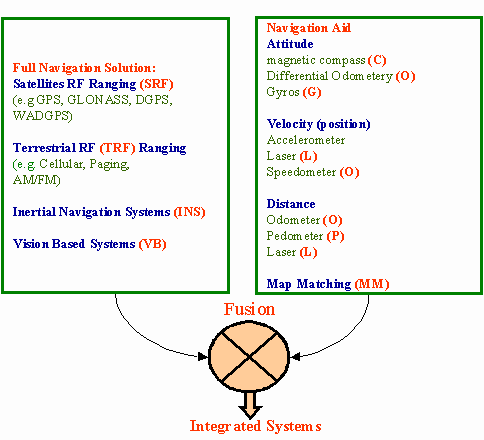
Navigation Systems |
Navigation Aids (navaids) |
Application |
|||||||||||
|
Vehicle |
Backpack |
|||||||||||||
|
SRF |
TRF |
VB |
INS |
MM |
L |
O |
P |
C |
G |
A |
||||
|
Current Systems |
1 |
Ö |
Ö |
Ö |
Ö |
|||||||||
|
2 |
Ö |
Ö |
Ö |
Ö |
||||||||||
|
3 |
Ö |
Ö |
Ö |
Ö |
||||||||||
|
4 |
Ö |
Ö |
Ö |
|||||||||||
|
5 |
Ö |
Ö |
Ö |
Ö |
||||||||||
|
6 |
Ö |
Ö |
Ö |
Ö |
Ö |
|||||||||
|
7 |
Ö |
Ö |
Ö |
Ö |
Ö |
|||||||||
|
Possible Systems |
8 |
Ö |
Ö |
Ö |
Ö |
|||||||||
|
9 |
Ö |
Ö |
Ö |
Ö |
Ö |
|||||||||
|
10* |
Ö |
Ö |
Ö |
|||||||||||
|
11 |
Ö |
Ö |
Ö |
Ö |
||||||||||
|
12 |
Ö |
Ö |
Ö |
|||||||||||
|
13 |
Ö |
Ö |
Ö |
Ö |
||||||||||
|
14 |
Ö |
Ö |
Ö |
Ö |
Ö |
|||||||||
Table 2: Characteristics, Limitations, and Applications of Systems Scenarios
|
Scenario |
Navigation State |
Characteristics/Current Limitations |
Applications |
|||
|
r(t) |
v(t) |
R(t) |
||||
|
Vehicle |
Backpack |
|||||
|
1 |
Ö |
Ö |
|
Car navigation |
Hikers |
|
|
2 |
Ö |
Ö |
Ö |
|
Military Navigation |
Seismic Applications |
|
3 |
Ö |
Ö |
Ö |
|
Highway inventory systems |
|
|
4 |
Ö |
Ö |
|
Car navigation |
||
|
5 |
Ö |
Ö |
Ö * |
|
Car navigation |
|
|
6 |
Ö |
Ö |
|
Navigation |
||
|
7 |
Ö |
Ö |
Ö * |
|
Mapping applications |
Mapping applications |
|
8 |
Ö |
Ö |
Ö * |
|
Mapping applications Target tracking |
|
|
9 |
Ö |
Ö |
Ö * |
|
||
|
10 |
Ö |
Ö |
|
Car navigation |
||
|
11 |
Ö |
Ö |
Ö * |
|
Targeting tracking |
|
|
12 |
Ö |
|
Car navigation |
|||
|
13 |
Ö |
Ö * |
|
Car navigation |
||
|
14 |
Ö |
Ö |
Ö * |
|
Navigation |
|
Provides heading only
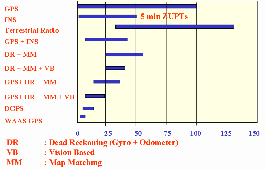
Figure 3: Performance Comparisons of Various Integrated Systems
3. FUTURE TRENDS
The trend towards integrated systems in positioning and navigation is fuelled by the demand for high accuracy, lightweight, low cost, and by technological developments which satisfy this demand. Three developments are especially important in this context: the progress in MEMS based INS systems, future enhancement to GPS, and future trends of vision-based systems and map matching. There is no question that that GPS will be part of any future integrated system, if GPS signals can be received for at least part of the time
The Progress in MEMS Technology: The Progress in MEMS Technology will enable in the near future complete inertial navigation units on a chip, composed of multiple integrated MEMS accelerometers and gyroscopes. In addition to single-chip inertial navigation units, there are many opportunities for MEMS insertion into low-power, high-resolution, small-area displays and mass data storage devices for storage densities of terabytes per square centimeter. These opportunities are essential if vision based systems are to be fully integrated into a backpack integrated navigation system.
Figure (4) relates the predicted development of MEMS-based inertial sensors to three major performance parameters - bias, scale factor and noise. These parameters are usually considered when judging system accuracy. They show that, for the medium term, two conclusions are possible at this time. First, MEMS-based inertial sensors will in general reach higher performance levels than the MEMS-based IMU-on-a-chip. This simply indicates that performance is dependent on the physical dimensions of the sensor or system. Second, it appears possible that MEMS-based tactical IMUs will become a reality within a ten year time frame, but that navigation-grade systems are rather unlikely during that period. For more details see Schwarz and El-Sheimy (1999), Barbour (1996), and Allen et. al. (1998).
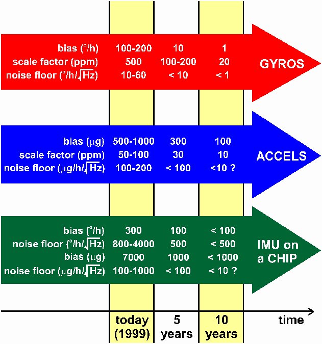
Figure 4: Predicted Development of MEMS-Based Inertial Sensors
The Future Enhancement of GPS: The proposed enhancements to GPS have the common goal of increasing both the capability and robustness of the system. The possible major modifications to the system include the removal of the intentional degradation of the signals (SA), the introduction of new signals, improvements in the control segment functions and increases in the size of the GPS constellation. The potential effects of these have been lumped together and are shown in Figure (4). It is estimated that they will improve the 2DRMS to about 9.5m. These are long term goals and no firm commitments have yet been made.
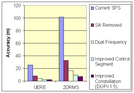
Figure 5: Improvements in GPS Single Point Accuracy Due to Potential Improvements (Average DOP = 2.0 Unless Otherwise Marked).
Figure (5) shows the following (for more details see Schwarz and El-Sheimy, 1999 and NAPA/NRC, 1995 report):
- Removal of SA: the removal of SA will improve the 2DRMS accuracy from 101.4 to 32.5m.
- New signals: under conditions of no SA, dual frequency corrections improve the 2DRMS from 32.5m to 16.6m.
- Increasing the Size of the GPS Constellation: this would result in an improvement of the 2DRMS from 9.5m to 7.1m, assuming that all of the other potential improvements named above have been implemented.
- Increasing the Size of the GPS Constellation: this would result in an improvement of the 2DRMS from 9.5m to 7.1m, assuming that all of the other potential improvements named above have been implemented.
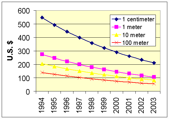
Future Trends of Vision-Based Systems and Map Matching Techniques: Conceptually, the vision-based concept is very attractive. Current experimental systems are limited in range and are oriented towards robotics applications. Figure (6) shows the future trend in digital cameras prices, resolution, and weight. The price and weight are going down while the resolution is going up. VBS hardware (digital cameras, storage devices, portable computers) could currently support the development of an autonomous VBS at the level of 10K US$ and a weight less than 2 kg. This indicates that low-cost and lightweight systems based on digital cameras are feasible. The major challenges are algorithms and software that make their use in unstructured environments possible. Smart image matching and 3D modeling of the VBS environment are not at a stage to support such a development. What complicates the problem is that the currently market demand for a stand-alone VBS is limited.
Because of these problems, its not expected VBS will be implemented as stand-lone navigation system in the next 5 years that but rather as a component of an integrated system. Possible scenarios include GPS and INS. The integration of GPS/INS with vision systems has been used in a number of post-mission mapping applications (El-Sheimy, 1996, and Schwarz, 1998). The current limitation for their implementation as autonomous navigation systems for land and backpack systems is mainly due the size, weight, and cost of GPS and INS. The integration of VBS with MEMS-based tactical-grade IMU and a GPS chip can be seen as one solution to this problem. The exterior orientation parameters can in this case be determined by a combination of GPS and INS. The result is a series of georeferenced images, i.e. of images with their six parameters of exterior orientation 'stamped' on them. Once, this stamp has been put on the image, the time dependence has been eliminated, i.e. each image has a unique position and orientation in space. Therefore, the major part of image matching and modeling the 3D environments around the system is rather simple. Whether a prototype system can be built in the next 5 years will mainly depend on the cost of the MEMS-based tactical grade IMU. In a 10-year period such scenario will be more feasible as the cost of MEMS-based tactical-grade IMU will be at the level of $500-$1000. The second scenario is a navaid-based backpack system, which if foreseen to happen within the next 5 years. It will ingrate a VBS with navaid such as pedometers and compass (Judd, 1997). Current backpack systems that integrate GPS, pedometer, altimeter, and compass already exist. Their cost is about $2000 and their weight less than 3 oz.
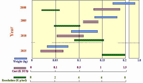
Figure 6: The Trend in Digital Cameras Prices, Resolution, and Weight
Although there are some problems with map matching, it has a number of advantages and is used in 25% of systems surveyed by Krakiwsky (1996). The map matching system is relatively inexpensive as it only requires cheap sensors, such as the odometer and/or the ABS (Anti-lock Braking System) pulses. There is no external infrastructure required and the accuracy of the system is fundamentally limited by the accuracy of the digital maps and the matching algorithm. Successful map matching is reliant upon maps that are complete and accurate to better than 30m absolute. This is becoming less of a problem as companies such as Navtech/EGT and Etak in the USA, Teleatlas in Europe, the Japan Digital Road Map Association, and Geographic Technologies (Telstra) in Australia have accurately mapped or plan to map the major cities, urban areas, and major highways in their region of interest. Finally, the development of portable navigation systems that are map-based should increase with the availability of less expensive, more intelligent digital road maps. A map-based personal navigation assistant (PNA) that supports path finding and route guidance for backpack applications is another development that may not be too far away.
ACKNOWLEDGMENT
The material presented in this paper has been part of a study performed under the Scientific Services Agreement with Batelle, Columbus Division and Topographic Engineering Center, Fort Belvoir, VA, USA. The principle investigators for this study were Drs. Klaus Peter Schwarz and Naser El-Sheimy, faculty members at the Department of Geomatics Engineering, The University of Calgary, Calgary, Alberta, Canada. In preparing this paper, I would like to specifically acknowledge the contributions of Mr. Alex Bruton, Ph.D., a candidate at the same institution for his contribution to the MEMS aspects of this paper.
REFERENCES
Allen, J.J, R.D. Kinney, J. Sarsfield, M.R. Daily, J.R. Ellis, J.H. Smith, S. Montague, R.T. Howe, B.E. Boser, R. Horowitz, A.P. Pisano, M.A. Lemkin and A.C.T. Juneau (1998): "Integrated Micro-Electro-Mechanical Sensor Development for Inertial Applications", Proceeedings of IEEE PLANS 1998, pp. 9-16.
Barbour, N. (1996): "Status of Inertial Systems", Paper presented at ION National Technical Meeting January 22-24, 1996, California.
Charting the Future (1995): A report jointly sponsored by the National Academy of Public Administration (NAPA) and the US National Research Council (NRC).
DARPA (1998): "Microelectromechanical Systems (MEMS) ", Electronics Technology Office, DARPA, http://web-ext2.darpa.mil/eto/mems/index.
Judd, T., (1997): "A personal Dead Reckoning Module", ION GPS’97 meeting, Kansas City, MO, USA.
Krakiwsky, E. J., (1996): "Assessment of Positioning and Navigation Technologies for Intelligent Transportation Systems", A report prepared for TRANSPORT CANADA and INDUSTRY CANADA, Aerospace and Defense Branch, by Intelligent Databases International Ltd., Calgary, Canada
Nexus Market Analysis Task Force Issues Market Study Report on MEMS/MST (1998), Micromachine Devices Magazine, Vol. 3, No. 10, October 1998, pp 1-5.
Schwarz, K.P. (1998): "Mobile Multi-Sensor Systems - Modelling and Estimation", Proc. of the Int. Symp. on Geodesy for Geotechnical and Structural Engineering, Eisenstadt, Austria, April 20-22, 1998, pp 347-360.
Schwarz, K.P. and El-Sheimy, N. (1999): "Future Positioning and Navigation Technologies" Study performed under the Scientific Services Agreement with Batelle, Columbus Division and Topographic Engineering Center, Fort Belvoir, VA, USA.
U.S. D.o.D. (1995): "Microelectromechanical Systems Opportunities", A Department of Defense Dual-Use Technology Industrial Assessment.
Biographical NOTE
 |
Dr. Naser El-Sheimy – is an Assistant Professor at the Department of Geomatics Engineering of the University of Calgary. He holds a B.Sc. and M.Sc. from Egypt, two post-graduate Diplomas in Photogrammetry and Remote Sensing from ITC, the Netherlands, and a Ph.D. from the University of Calgary. His area of expertise is the integration of GPS/INS/imaging sensors for mapping and GIS applications with special emphasis on the use of multi-sensor in Mobile Mapping Systems. He is now the chairman of the special study group for Mobile Multi-Sensor Systems of the International Association of Geodesy and the chairman of The International Federation of Surveyors (FIG) working group C5.3 on "kinematic and Integrated Positioning Systems" |
Dr Naser El-Sheimy
Assistant Professor
Chair FIG C5 WG 1: Kinematic and Integrated Positioning Systems
Department of Geomatics Engineering
The University of Calgary
E-mail: naser@geomatics.ucalgary.ca
Web: http://www.geomatics.ucalgary.ca/~nel-shei/
24 April 2000
![]()
This page is maintained by the
FIG Office. Last revised on 15-09-04.