News in 2013
|
Reference Frame in Practice
21-22 June 2013, Manila, Philippine
FIG Commission 5 in South East Asia,
Manila – Philippines
FIG Commission 5 actively participated in 2 events in this unique region to
represent our membership and to raise the profile of the Commission. The two
events held in Manila where –
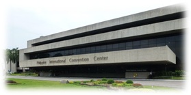
SEASC was held at the Philippine International Convention Centre
(PICC). It attracted 665 guests comprising of local surveyors, international
registrants from different countries in the Asia Pacific region, corporate
sponsors and administrative / technical support. There were 15 plenaries and 85
technical presentations all of which were related to the theme “Geospatial
Cooperation Towards a Sustainable Future”. The National Mapping and Resource
Information Authority (NMARIA), and Philippine Engineering and Geomatics Society
(PhilGEGS) organised this congress for the ASEAN Federation of Land Surveying
and Geomatics.
SEASC was held at the Philippine
International Convention Centre (PICC). It attracted 665 guests comprising of
local surveyors, international registrants from different countries in the Asia
Pacific region, corporate sponsors and administrative / technical support. There
were 15 plenaries and 85 technical presentations all of which were related to
the theme “Geospatial Cooperation Towards a Sustainable Future”. The National
Mapping and Resource Information Authority (NMARIA), and Philippine Engineering
and Geomatics Society (PhilGEGS) organised this congress for the ASEAN
Federation of Land Surveying and Geomatics.
It is to be noted that FIG President Teo CheeHai, and Young Surveyors Network
Chair Kate Fairlie were also present at SEASC, thus their impressions and
findings should also be read in conjunction with this report.
 |
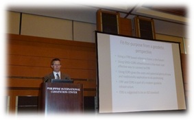 |
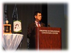
FIG Commission 5 Chair, Mikael Lilje, was heavily involved in the SEASC
program. Mikael delivered several presentations, and with Vice Chair of
Administration Rob Sarib both were actively involved in subsequent discussion
forums on behalf of FIG and Commission 5. These were –
- A plenary presentation about the contributions, roles and functions of
Commission 5 towards geospatial co-operations for a sustainable future in
the region.
- An overview presentation of Commission 5 and its activities to the
Philippine Young Surveyors Forum
- Technical input into the round table discussions on Strengthening
Disaster Risk Reduction Management in the ASEAN Region by highlighting the
technical papers and publications previously done by FIG on disaster
management.
- A technical presentation at the round table discussion on the Adoption
of Common Reference System for the ASEAN Region. The presentation delivered
at this forum focused on hierarchical arrangement and initiatives associated
with the international reference frame, regional reference frames,
applications and services, and the involvement of our sister organisations
International Association of Geodesy (IAG), and United Nations Global
Geospatial Information Management – Asia Pacific (UN GGIM-AP) on such
issues.
The Commission 5 “take home messages” from SEASC proceedings, and our
involvement in various forums pertaining to this region were as follows –
- Geo -spatial data infrastructure (SDI) needs to be “fit for purpose” and
“maintainable”.
- The importance of developing fundamental SDI framework components, such
as institutional, legal, technical, data accessibility and timeliness, data
quality and accuracy, are re-emerging as key drivers or justification for
geospatial action.
- The increasing use of “cloud” technology for accessing data, integrating
data, computations, crowd sourcing and engaging users / citizens of
geo-spatial information.
- The need for smarter data collection / gathering / management techniques
for the large quantities or “mass” amounts of data / information that is
coming in the future.
- The need for up to date specifications, uniform practices and standards
for new measurement techniques and mass data from sources such as laser
scanners, digital cameras, LIDAR, INSAR, IFSAR, digital imagery etc.
- The ongoing need for building the capacity of not just young surveyors
but also the mature or present surveyors.
- Education of geo-spatial data users.
- More promotion of FIG and sister organisation initiatives and our role /
function so as to avoid duplication and the wasting of the precious industry
“time and limited resources”. For example the better use of International
GNSS Service (IGS) services and expertise, and the Asia Pacific Reference
Frame (APREF) and its frameworks, services, and intellectual network.
- 70% of the world’s wealth is associated with land related activities and
as FIG has an important role in this industry this needs to be emphasised at
all levels of SDI organisations.
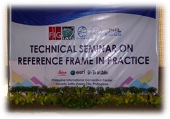
The RFIP technical seminar was an important event for not only FIG
Commission 5 but also to IAG and UNGGIM – AP. The objectives were to –
- Facilitate a regional forum for geodetic agencies but focussed on the
needs of Asia and the Pacific.
- Build the geodetic capability of the Asia Pacific through technical
agency-to-agency exchange.
- Improved data sharing and international participation in the APREF
initiative and IGS.
 |
 |
The RFIP event was organised with local surveying organisation PhilGEGS
(Philippine Geodetic Engineering and Geomatics Society) and it was co-sponsored
by the IAG, UN GGIM-AP and the UN-International Committee on GNSS (ICG), with
generous corporate support provided by ESRI, Trimble and Leica Geosystems. There
were over 40 participants who were primarily from the region and the Pacific
islands. Four participants were provided financial assistance from the UN Office
for Outer Space Affairs (UNOOSA). The technical seminar was also convened at the
PICC.
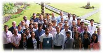
The 2 day seminar consisted of 20 technical presentations and these speakers
were from Australia, New Zealand, Japan, Korea, Philippines, Singapore,
Indonesia, Fiji, PNG, and Sweden. The event secured the presentation services of
experts such as Prof. Chris Rizos from the IAG, Dr. John Dawson from GeoScience
Australia, and numerous geodetic specialists from the UN GGIM – AP working group
such as Prof. Kwon Jay-hyoun and Mr Tetsuro Imakiire. The organisation and
administration of the technical program was controlled by Commission 5, and
presentations were specifically aimed at reference frame, geodetic and
positioning issues and infrastructure. The general topics were –
- The Status and Issues of Geodetic Infrastructure from Countries in the
Region
- IGS Services and Other Initiatives
- APREF Status and Determination
- Reference Frame Infrastructure
- Gravity and WHS
- Multi-GNSS Environment
- Going GeoCentric
- Dynamic Datums
- The Role of Manufacturers in Geodetic Infrastructure
For the more detailed information about the presentations navigate to our
Commission 5 website -
http://www.fig.net/commission5/index.htm.
From a FIG Commission 5 perspective this event was a success. It brought to the
attention of various geospatial / geodetic agencies and users in the region the
opportunities, benefits and efficiencies to be gained by utilising APREF and the
services from IGS. Further discussions highlighted the way forward for APREF and
revealed the primary issues that are hindering participation of countries, such
as the lack of resources (funding), knowledge and experience, and prohibitive
data exchange or sharing policies. The event also enabled participants to expand
their professional network and to actively pursue operational assistance with
their specific agency issues with experts or specialists in the related fields /
disciplines.
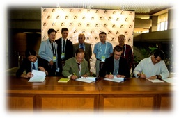
The profile of FIG Commission 5 was also enhanced in this
region. FIG’s ability to connect with operational surveyors is a well-respected
asset in this region, and this was clearly demonstrated by the elaborate
ceremonial signing of the RFIP TS Manila agreement with the President of
PhilGEGS – Avelino L San Buenaventura, and dignitaries. Many participants also
commented on how valuable the information was to their agency and that they
(including presenters) would like to participate in similar technical seminars
in the future. From a PhilGEGS perspective this event was very important to
their regional profile and the geodetic community as they are developing
strategies and implementation plans to modernise their geodetic framework by
adopting an ITRF based “geocentric datum”. In fact, an additional outcome from
this event was a proposal from PhilGEGS to hold a 3 day workshop on this
specific geodetic subject. This event is proposed for early June 2014 on the
Philippine island of Boracay, and would be seeking possible FIG, IAG and UN
GGIM-AP support and assistance.
For FIG Council’s information and interest, a technical manual on “Reference
Frames in Practice”, that uses specific information from this event and the RFIP
seminar held previously in Rome, is currently under preparation. It is
anticipated that it will be ready for FIG publication and be officially released
at our Congress next year in Kuala Lumpur. Achieving this will fulfil part of
Commission 5’s work plan commitments but it will also further consolidate joint
IAG – FIG – UN GGIM AP activities and serve as foundations for the years to
come.
FIG Commission 5 wishes to acknowledge local hosts Mr. Randolf Vicente, Ms.
Charisma Victoria Cayapan, and other PhilGEGS representatives for their generous
assistance and great hospitality.
Finally FIG Commission 5 recommends that this report be noted and then
circulated to the other FIG Commission Chairs for their information, as this may
help them prepare technical programs for their activities in the region and also
the Congress.
Further information:
Mikael Lilje and Rob Sarib
June 2013
|
