News in 2019
|

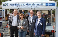
The top representatives of the four geodetic scientific societies, all of which are currently from Germany, in front of the Leibniz University Hannover booth at the Day of Geodesy: (from left) Prof. Rudolf Staiger (President FIG), Prof. Monika Sester (Vice President ICA), Prof. Harald Schuh (President IAG ) and Prof. Christian Heipke (President ISPRS).
During the Day of the Geodesy on 24 May, 2019, the leaders of the four international scientific societies in the field of geodesy and geoinformatics met for talks in Hanover. Prof. Monika Sester (Leibniz University Hannover) represented the International Cartographic Association (ICA) as its Vice President; the other three societies were represented by their presidents: Prof. Harald Schuh (GeoForschungszentrum Potsdam) participated in the meeting for the International Association of Geodesy (IAG), Prof. Rudolf Staiger (University of Bochum) for the International Federation of Surveyors (FIG ) and Prof. Christian Heipke (Leibniz University Hannover) for the International Society for Photogrammetry and Remote Sensing (ISPRS). What is remarkable about this meeting is that all four representatives come from Germany. This constellation, which has been unprecedented in the more than 100-year history of the societies, impressively documents the importance of German science in international geodesy and geoinformatics.
After a presentation of the international organizations to an interested
professional audience in the rooms of the Leibniz University in the
morning, the four representatives met in the afternoon for a 45-minute
public panel discussion, in which they highlighted the role of geodesy
and geoinformatics for society at large. In addition to the classical
task of surveying and mapping of the earth's surface the documenting the
legal boundaries of land property, the main topic was the role of
geodesy in the age of digitization and climate change, e.g. for mobility
and autonomous driving, for sustainable urban and rural development,
earth observation and natural hazards, but also in robotics and
navigation. Without the often less visible geodetic contributions,
reliable data would not be available in the required quality, neither
for sea level rise nor for high-precision positioning in real-time or in
disaster management.
The full range of geodesy is also expected to make significant
contributions to achieving the United Nations' Sustainable Development
Goals (SDGs). According to estimates by the World Bank, only about 30%
of the land is registered worldwide, which is why experts in cadastre
and land management are in great demand.
In addition to these all speakers emphasized the broad field of activity
and the high attractiveness of geodesy - in which full employment is
virtually guaranteed today. Against this background, the subject of
geodesy and geoinformatics can be highly recommended to prospective
students.
Following the public discussion, the representatives of the scientific societies met for an internal exchange of ideas in which possibilities for closer cooperation were discussed. An improved exchange of information, a common representation at scientific and professional meetings and events of outreach and further education were agreed, especially in areas where interfaces exist. Cooperation is also to be intensified in areas relating to geodesy and geoinformatics in general, such as education and recruitment, scientific publications, and the visibility of the subject in politics, administration and the society at large on a national and international level.
Further information about the scientific societies can be found here:
FIG: International Federation
of Surveyors www.fig.net
IAG: International Association of
Geodesy www.iag-aig.org
ICA: International
Cartographic Association icaci.org
ISPRS: International Society for Photogrammetry and Remote
Sensing
www.isprs.org
Rudolf Staiger
June 2019