AUSTRIA AND SWITZERLAND
1. Introduction
In the Federal Republic of Germany, in Austria and Switzerland high sophisticated systems to guarantee the security of land tenure have been established. With a long history of land registration in these states it is a proven fact that a good working system of security of land tenure is very important for a developed society. The consequences of a land registration system badly maintained or even not existing can be demonstrated with the experiences in the new states of Germany after the unification. Investments in land and buildings have been very difficult or even not been possible before re establishing a land registration system like in the rest of the country. The German system of land registration is a dual one, land registration and cadastre are established in different organisations. This paper describes the contents and the interactions of both systems to secure land tenure putting the main emphasis on the German situation. The cadastral systems in these countries with their additional contents in maps and records are a basic Land Information System.
2. Historical Review
2.1 Germany
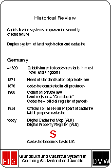
Security of land tenure in Germany has a tradition of some centuries. The forms of land registration in former centuries had great variety because of the great number of independent states on the territory of the present Federal Republic of Germany. The basic laws have been quite different as well, because since the end of the 30 years war in 1648 states like Prussia or Saxonia have been completely independent.At the beginning of the 19th century in some of the kingdoms cadastral systems have been established for taxation purposes. In some of the western provinces the establishment of cadastral systems for taxation purposes are based on the cadastres that were established by Napoleon in the occupied areas left of the river Rhine. Until 1876 the cadastre in Prussia was completed. Although the main purpose for the establishing of a cadastre was taxation of land, the idea of using maps and records for further purposes of governmental activities was implemented in the cadastral systems from the beginning.
After the German Reich was founded in 1871, the need of standardisation of the private law was evident. Since January, 1 1900 the common private law exists for the whole country. In connection with this law the land registration system for the whole country has been established. This land registration system (in German terms called "Grundbuch") contents all rights of ownership and other rights on land and buildings. With establishing this system the importance of good working cadastral system grew very fast. The description of the land parcels (parcel identifier and cadastral maps) became the official and legal register of parcels as a part of the land register. Cadastre developed from a system for taxation of land to a register to guarantee the right of land tenure.
After 1934 the results of the official soil assessment are recorded in the cadastre. This was the first step into the direction of a multi-purposed cadastre.
The constitution of the Federal Republic of Germany accords responsibility for legislation around the land register to the Federal Republic whereas the states make the laws concerning the property cadastre. Interstate bodies (working group of state survey agencies) ensure uniformity of the property cadastre.
In these days the cadastre fulfills all legal demands and demands of administration and the private sector. It is a basic Land Information System (LIS) of great variety and flexibility in planning, environmental protection etc. Maps and cadastral records in most parts of Germany are stored in computer systems. Although cadastre in Germany is in the responsibility of the 16 states the computerised systems are unique with some small exceptions. These systems are the automated cadastral map (ALK) and the automated property register (ALB).
2.2 Austria
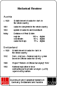
Like in Germany cadastre started in the early 19th century for taxation purposes. The establishment of the cadastre for the whole state of Austria was completed in 1861. Since 1883 cadastre and Grundbuch are updated bringing both systems into line.Like in Germany both systems are held in separate organisations, Grundbuch is part of the local courts and cadastral offices are under the administration of the Ministry for Building and Technic.
The changes of the cadastre in direction to a multi-purposed cadastre follow the same developments like in Germany.
In these days the information about legal ownership of parcels and other titles is contained in the Austrian "database of real estates" which is the official register of all Austrian real estates together with all technical and legal information concerning them. It consists of three parts: the real estate register (100% digital), the database of coordinates (approx. 60% digital) and the cadastral map (approx. 15% digital).
2.3 Switzerland
Similar to France and some western and southern parts of Germany the cadastral system in Switzerland is based on the Code Napoleon.The Swiss Civil Law from 1912 constitutes the basis for the "Federal registry system". This Grundbuch-system has to be based on an official cadastral surveying. Like in Germany the land register is the legal system, the cadastral part is maintenance of control points, cadastral mapping, general mapping at scales 1:5000 and 1:10.000.
Switzerland has a federative political system. According to this system, cadastre is delegated to the Cantons. The Confederation is supervising and subsidizing the Cantons. The Cantons themselves are contracting out the actual work to private surveyors and are limiting their work in supervision of these private surveyors, about 270 private offices are involved in this business.
In the early 1980`s a project was started, called "Reform of Official Surveying" in order to emphasize the enlarged user community by minimizing the federal regulations, increasing actuality, liberalising data acquisition methods and so to improve the cadastral services. Since 1993 a new national legislation has been put to force. The realisation has been started by legislation on cantonal level and the necessary organisational and financial dispositions.
3. Land Register
3.1 Material and formal laws
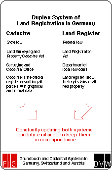
Laws on the field of land tenure in Germany are separated in a material and a formal part. The material right contents the regulations for changing rights on a piece of land, selling and buying, regulations of the relationship from person to person and from person to land. The material law is part of the private law (in German "Bürgerliches Gesetzbuch, BGB").The formal law (in German "Grundbuchordnung, GBO") contents the regulations for the land registration, the offices and the rules how to register the different forms of land tenure. Both laws are federal laws.
3.2 Organisation of the land register
The land registration offices are part of the administration of justice in the 16 German states. The jurisdiction of the land registry officials, the form of establishing and maintaining the land register are manifested in the GBO and in additional orders of the federal minister of justice. The regulations of the organisation of the land registry are given by the states` ministries of justice.The land registries are part of the local courts. They are responsible for the land registration of the properties of land in their district. These districts are manifested by law. Land registry officials are
* the district court judge as a land register judge,
* the administrators of justice,
* the nominated official of the land registration office, and
* the official for certifications of the land registration office.
The administrator of justice is responsible for all external business of the land register. He is able to decide independent, his decisions are regulated and restricted only by law. The official for certifications has to register the contents of the administrator of justice in the register and countersign the records in the register.
3.3 Contents of the land register
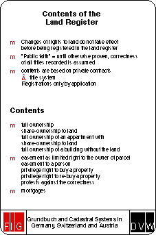
The land register shows the legal status of all real property. In its documentation and publication role it functions as the statutory basis for property conveyancing, in particular to ensure unequivocal status of ownership and other titles, as well as for mortgage loans. The land register is characterised by two important legal principles:* Changes of rights to land do not take effect before being registered in the land register.
* Until otherwise proven, the correctness of all titles recorded on the register is assumed. The land register enjoys the "public faith", in other words, the details registered may be presumed correct by anyone acquiring a legal title with regard to property unless an appeal against the correctness is recorded or the person acquiring the title is aware of the entry being incorrect.
Registrations therefor play an important legal role. They are in force until the evidence of the reverse. So do some contents of the cadastre, like the parcel-identifier in maps and records.
The contents of the land register are based on private contracts certified by public notaries. It is not a deed system, but the contracts are stored in the files belonging to each record.
Registrations are done only by application. So normally the land registry does not become active on their own.
Rights on land being able to register are
1. land tenure
* ownership,
* share-ownership of a property,
* ownership of a building without ownership of the land (long term lease),
* full ownership of an apartment in combination with part-ownership to the land,
* easement as a limited right for an owner of one parcel to use or prevent use of some kind of a neighbouring parcel. The right is connected to a parcel, like rights-of-ways,
* easement as a limited right for a person or the community, like the right for the municipality to build a gas pipe on private ground,
* mortgages in different forms to secure loans,
* the privilege right for a person to buy a property,
* the privilege right to re-buy a property.
2. Protests against the correctness of records and other restrictions
3.4 Formal structure of land records
There are two ways of register land tenure,* the real folio, in which each parcel is registered in a special folio,
* the personal folio, in which all parcels of an owner are registered in one folio.
The personal folio is the common one in these days.
Generally each parcel has to be registered in the land register, except parcels in state ownership which are not part of a normal land market, e.g. streets.
A folio has a structure described as follows (enclosure 1):
1. title
* responsible district court,
* district,
* number of folio.
2. List of properties
* numbers of properties,
* numbers of parcels (a property may be separated in a number of parcels),
* description of parcels (area, land use, location),
* rights of the owner to other parcels (leaseholds),
* share-ownership.
3. part I
* name of the land owners,
* number of properties.
4. part II
* all forms of easement, protests and other restrictions,
* ranking of rights.
5. part III
* all forms of mortgages.
Beside this official register there are files containing contracts and other documents related to the folio.
Any person has the right of access to the land register and getting extracts of it. This right is limited to a special interest to a special folio which has to be declared to the officials in order to follow the data protection regulations in Germany.
4. Cadastre
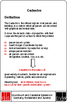
4.1 Definition
The cadastre in Germany is defined as the official register of all parcels and buildings in a state, in which all parcels are described with graphical and textual data. The real property cadastre is designed to show the de facto status of property. As far as legal property titles are concerned, the cadastre shows their scope and the part of the surface to which they extend. All relevant facts, such as designation, location, size and use, plus the boundaries as surveyed by authorised government agencies and licensed surveyors are therefor described.The cadastre therefor is the only register in which all parcels and buildings in a state are described. In addition it contains additional information, like the results of the official soil assessment. With some parts of its contents the cadastre enjoys the "public faith" of the land register, like parcel-identifier in maps and records.
The cadastre in Germany is a parcel-based system, i.e. information is geographically referenced to unique, well-defined units of land. These units are defined by formal boundaries marking the extent of land. Each parcel is given a unique parcel-number.
The cadastre, based on cadastral surveying, shows the division of the ground in form of parcels and contains information about the de facto status of property (location, size, use etc.). The land register contains the describing parts of the cadastre. Therefor only both systems in combination are able to give a complete overview about legal and de facto land tenure. Both registers must be constantly updated and kept in correspondence with each other.
4.2 Organisation
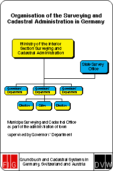
With respect to the federal constitution of Germany the responsibility for legislation in the field of cadastre is in the hand of the states. The states have passed various, basically uniform, laws in the field of surveying. The ministry responsible for surveying varies from state to state, normally it is placed in the ministry of the interior, but in some states as well in the ministry of finance, trade and commerce, or building and construction.In the majority of German states the surveying and cadastral services have a three-tier structure:
* supreme surveying and cadastral authority (state government ministry), dealing with principles, preparing legislation and issues administrative rules and guidelines for a uniform implementation of the tasks as the top supervisory body;
* higher surveying and cadastral authority, duties at this level are carried out by the governors` departments (administrative subdivisions of the state governments) covering the territory of several shires and unincorporated cities. They supervise the local cadastral and surveying agencies as well as the licensed surveyors, issue general and specific directives and provide assistance wherever the local services need it;
* lower surveying and cadastral agencies, their jurisdiction covers the territory of a shire or an unincorporated city. They are tasked to maintain and update the real property cadastre. The organisation of a cadastral agency varies when these offices have taken over more communal tasks like land valuation, planning etc. An organisational chart is enclosed.
4.3 Tasks of the surveying and cadastral agencies
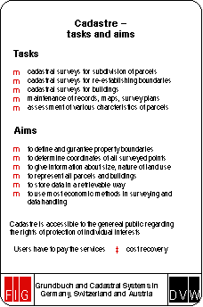
The main task of the surveying and cadastral agencies is the maintenance and the updating of the real property cadastre. Since the development to a multi-purposed cadastre the task grew constantly. In these days the cadastre is the basic parcel-based land information system for an increasing number of private and public users in land development, urban and rural planning, land management and environmental monitoring.In maintaining and updating the cadastre, there are a number of legal, technical, and operational issues that must be resolved according to the needs and constraints of each jurisdiction.
Main tasks are
* cadastral surveys for subdivisions of parcels,
* cadastral surveys for re-establishment of boundaries,
* cadastral surveys for buildings,
* maintaining the cadastral records, maps and survey plans,
* assessment of other characteristics of the parcels, like land use, area, additional information for different users, e.g. curbs, trees and other topographical information in maps and textual records like the soil assessment.
It is the aim of the cadastral survey
* to define and guarantee property boundaries,
* to determine coordinates of all surveyed points,
* to give information concerning the size and the nature of land use,
* to represent buildings or other constructions.
All information have to be stored in a way that they are retrievable and have to be maintained and updated by using the most economic methods in surveying and storing the data.
The cadastre is accessible to the general public in accordance to the rights of protection of individual interests. Person-related information can be given away to those users that have a special interest e.g. in buying a parcel. Not person-related information are accessible to the general public without any restrictions.
The users of the cadastre have to pay the services offered by the cadastral agencies. The provision of information from the system is more or less based on cost recovery.
The formerly parcel register in most parts of Germany is operated in a digital system called Automated Property Register (ALB). The cadastral maps are digitised in most parts of Germany. This project is called Automated Property Map (ALK). These systems are more or less unique in all states, so that a nation-wide user can have access to the same structure of data across the whole nation. Both information systems, ALB and ALK define the basic Land Information System.
The surveying and cadastral agencies are working as well in the field of maintaining the nation-wide grid of revision points and height control points.
Additional tasks linked to the cadastre are the valuation of land and buildings, the maintenance and updating of the collection of purchase prices, giving expertise on the market value of any kind of land property and the publication of standard values for different kinds of land prices.
Further tasks in most states are land management activities, like formal procedures for (re)organising building land in course of development planning.
4.4 Contents of the cadastre
Stored details for each parcel in ALB are* name, date of birth, address, shares of the land owner,
* location of the parcel, like street-name, house number, center-coordinates,
* district and parcel-number,
* area of the parcel,
* type of land use,
* results from official soil assessment,
* internal information about year of creation of the parcel, year of maintenance, number of cadastral map, number of survey plans,
* number of folio and property in the land register,
* additional details about the parcel, like parcel is part of a consolidation project, polluted soil, historical monuments, parcel is part of a nature reserve or a water reserve etc.
The analog cadastral maps exists generally in form of grid-maps scale 1:1000 based on Gauß-Krüger-coordinates. Most of these analog maps are now replaced by digital maps (ALK) containing geographical information about
* parcel boundaries and corner point markings,
* numbering of parcels,
* boundaries of districts,
* survey control points,
* outlines of houses and buildings,
* house numbers,
* street names,
* results from official soil assessment,
* type of land use,
* topographical details like kerbs, cycle tracks, trees, embankments, walls etc.
As an example of an official extract of ALB and ALK see enclosure 1. Because ALB and ALK are held in digital form extracts can be put together individually following the requests of the user in analog listings, plots or digital in well defined formats (e.g. DXF).
While ALB contains person-related information about the land owner the access to these data is restricted to persons with special interest access to ALK is unlimited to everyone. As an example the price for an extract shown in enclosure 1 is about 50 DM.
The cadastral maps must be suitable as a basis for development plans and for the revision of the official map series. According to the legal tasks of the cadastral maps the contents are based on terrestrial surveys (boundaries, houses and buildings). Topographical details sometimes may be put into the maps by photogrammetry. In areas with a high accurate cadastre it is possible to create new legal boundaries from existing plans by calculating without surveying in the field. To assist minor control point surveys and cadastral surveys commercial digital tacheometers are in use. So a complete data flow from survey to mapping may be possible. The major principle of surveying boundaries and buildings is controlling the work by an independent second measurement.
Final result of this work will be Gauß-Krüger-coordinates for all surveyed boundaries respectively corner points of parcels and buildings and control points. These coordinates are stored in a point file indicating nature of point, status, accuracy and reliability.
Respecting the legal importance of the boundary surveys requirements to accuracy are high. The maximum difference between the actual measurement according to older ones is different from terrain with low prices to regions in densely populated areas. E.g. in Hamburg the maximum difference between two measurements in an area with coordinates is 5 cm.
Parcel boundaries will be established (restored) either on application or ex officio. Established boundaries should be marked. The same applies to newly constructed parcel boundaries or boundaries settled by arrangement or judgment. Establishing and marking of boundaries proceedings involve the hearing of concerned land owners, who are to be notified in due course about date and location of the procedure. A record of the proceedings is to be taken (Demarcation Record) a copy of which may be forwarded to the owners involved.
Land owners and long-term leaseholders are obliged to inform the competent authorities about relevant changes pertaining their land; this applies especially to the construction of new buildings or changes to the exterior plan of existing buildings. Any necessary surveyings are at the expense of the owner.
Access to survey plans and point file is allowed only to persons who guarantee a proper use of the data.
The cadastre is permanently updated by the local cadastral office on the basis of
* applicated surveys carried out by the office itself,
* applicated surveys carried out by licensed surveyors and submitted to the office for the purpose of takeover into the cadastre,
* surveys carried out by other authorities,
* surveys to maintain the cadastre carried out by the office itself,
* notifications about changes from the land registry and the tax offices,
* notifications from different authorities about changes to the great number of additional information
Besides ALB and ALK in some states data about houses and buildings are held by the cadastral offices generally in digital form containing
* parcel identifier and identifier of building,
* central coordinate,
* house number,
* function of the building,
* number of floors, height of the building,
* area of building
* form of the roof.
The results of the official soil assessment carried out by the tax authorities are stored in the cadastre containing data about land used for agricultural purposes like
* farming
* gardening,
* grazing.
Exact descriptions of the soil and numbers indicating the value in comparison to an ideal soil of the value 100. So for taxation purposes indicators for the agricultural yield out of the land can be calculated very easy.
5. Cooperation of Land Register and Cadastre
How land register and cadastre work together shall be described with three examples.* Purchase of parcel
Purchaser and seller meet each other at the notaries office to fix the deed. The notary submits the deed to the land register. The land register registers the new land owner and notifies this to the cadastral office which takes over these changes.
* Purchase of part of a parcel
Purchaser and Seller meet each other at the notaries office to fix the deed. The deed includes the description of the part of parcel which is object to be purchased. This will be marked in the land register by application of the notary. Approvals for the subdivision are necessary. The subdivision of the parcel will be applicated at the cadastral office or a licensed surveyor. The subdivision will be overtaken into the cadastre. The cadastral office notifies the new parcel identifier in form of an extract of ALB and ALK to the land registry which overtakes the two new parcels into the register, the one to be purchased together with the new owner under a new number of folio and new property-number. The land registry notifies this to the cadastral office which registers the change.
* Maintenance of the cadastre
For reasons of maintaining an old cadastre in a somehow defined area there will be changes in the area or land use of a parcel which is surveyed in more accurate way than it was before. These changes will be notified to the land registry which overtakes these changes.
In a city like Hamburg (population 1.7 Million) 35.000 updates are registered, 20.000 originally from the land register, 15.000 originally from the cadastre.
In these days a project has been created to computerise the land register. For more synergy, an electronic data link will therefor be established between land register and cadastre for sending update-files, but without changing previous responsibilities.
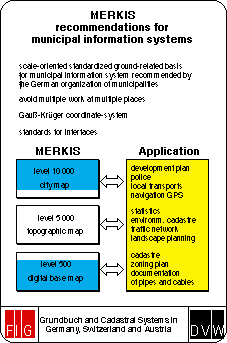
6. MERKIS, Recommendations for Municipal Information Systems
For the requirements of planning, environmental protection and a lot more of municipal aspects the German organization of municipalities (DST) published recommendations for a scale oriented standardised ground-related basis for municipal information systems (MERKIS).Standardised means
* to avoid multiple work in developing and updating of basic information by different institutions
* basic coordinate-system is Gauß-Krüger-system
* standards for interfaces have to be respected.
Integration means
* all decentral special information systems have to use one basic LIS
* the basic LIS is established and updated by only one office.
Because of a wide variety of municipal requirements for digital geometric data DST recommends three scale-levels:
level 500 digital base map 1:500 ... 1:2.500, integration of cadastral map
level 5000 not generalized topographical map 1:2.500 ... 1:10.000
level 10.000 town map (generalized) for giving an overview 1:10.000 ... 1:50.000.
7. Personnel Matters
The tasks in the field of cadastre and land registration are done by experts of different professions.1. Surveying and cadastre
* Geodesy and Cadastral Survey
* Cartography
* Computer science
* Agriculture
2. Land registration
* Jurisprudence.
In surveying and cadastre experts with a surveying profession in different levels are the majority (85%). The part of the Chartered Surveyors varies from state to state (0% to 80%).
In the land register are working almost exclusively jurist experts in different levels (98%).
8. Financing
Land registration and cadastre are subject to the public sector. Therefor these systems are financed through governmental funding. Part of the costs are covered by income from selling the information and using the services of these institutions.A distinction is made between the cost of establishing and maintaining the cadastre (e.g. establishment of ALK and ALB) as a "one off" cost which is borne by governmental funding. The costs for updating according to applications by or the provision of information from the system for the users is more often based on cost recovery.
Speaker: Dr.-Ing. Winfried Hawerk Tel. +49-40-34913-2133
c/o Freie und
Hansestadt Hamburg Fax +49-40-34913-2943
Postfach 30 05 80
D-20302
Hamburg
GERMANY
Maintainer : David Mercer - webmaster@fig7.org.uk Last Modified: September 1996.